Southeast Utah contains the greatest number and variety of trails in the state, including the narrow canyons of the San Rafael Swell, the stone sculptures of Arches National Park, the vast wilderness of Canyonlands National Park, the canyons around Lake Powell and the Anasazi ruins of Cedar Mesa.
Map shows trailhead locations
1. Arch Canyon, Cedar Mesa, Grand Gulch and Comb Ridge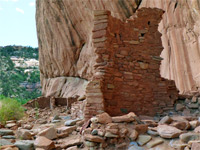 Length 2.5 miles (4 km); to the first high-level ruin Elevation change 170 feet (52 meters) Difficulty Easy Rating (1-5) ★★★★★ Northeastern Cedar Mesa canyon containing a large cliff dwelling ruin near its lower end, with pictographs and petroglyphs, while upstream are several smaller ancient sites, mostly high above the streambed. The canyon extends 14 miles in total, and has several arches in its upper reaches |
2. Aztec Butte Trail, Canyonlands National Park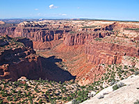 Length 1 mile (1.6 km) Elevation change 200 feet (61 meters) Difficulty Easy Rating (1-5) ★★★★★ Aztec Butte rises 200 feet above the plateau right at the center of the Island district, just north of Willow Flat campground. The easy trail to the top passes a cliff dwelling and several ancient Anasazi granaries, some reached by short spur paths, and also has good views over Trail Canyon that starts just to the north. |
3. Balanced Rock Trail, Arches National Park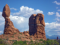 Length 0.4 miles (0.6 km); (loop) Elevation change 0 feet (0 meters) Difficulty Easy Rating (1-5) ★★★★★ Balanced Rock is a sandstone boulder perched on a column of softer rock, beside the turn-off for the road to the Windows section. Although easily seen from the highway, a short trail loops around the formation for a closer view. |
4. Baptist Draw Length 7 miles (11.3 km); round trip, to see the accessible upper parts of both canyons Elevation change 600 feet (183 meters) Difficulty Strenuous - dryfalls, chokestones, logjams, pools Rating (1-5) ★★★★★ Long, deep and narrow slot canyons, perhaps the best in the Swell, through colorful, nicely eroded rocks; equal in beauty and extent to the Navajo canyons of Page. Many obstacles make the passages quite difficult to explore, and ropes are needed at some points, but a fair amount can be seen by hiking and scrambling. The conditions can change dramatically after floods. |
5. Bell Canyon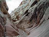 Length 1.8 miles (2.9 km); to the end of the enclosed section, 7.8 miles for the complete loop Elevation change 200 feet (61 meters) Difficulty Easy Rating (1-5) ★★★★★ Short ravine, not very narrow or enclosed, but bordered by nicely eroded rocks, with a great variety of textures and colors. Often hiked as part of a loop with adjacent Little Wild Horse Canyon. |
6. Blue John Canyon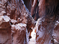 Length 8 miles (12.9 km); round trip Elevation change 600 feet (183 meters) Difficulty Moderate Rating (1-5) ★★★★★ Deep, branched slots in a remote but scenic region near the Green River and Canyonlands NP. Some parts require rappelling and/or difficult downclimbing, to pass dryfalls of up to 70 feet, but most can be seen by hiking and scrambling. The suggested trip, for hikers, is down the west fork, up the main fork to the steep part, then back cross-country to the start. Several other routes possible. |
7. Broken Arch Trail, Arches National Park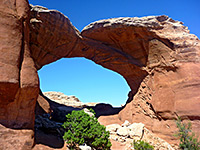 Length 1.4 miles (2.3 km); loop; level overall Elevation change 0 feet (0 meters) Difficulty Easy Rating (1-5) ★★★★★ Starting from Devils Garden campground (site number 40) near the north end of the scenic drive, the loop path to Broken Arch also passes close to Tapestry Arch, and encounters varied scenery of rock, sand and bushes. Both spans may also been seen via a longer (2.5 mile) loop hike starting from the trailhead for Sand Dune Arch. |
8. Bullet Canyon, Cedar Mesa, Grand Gulch and Comb Ridge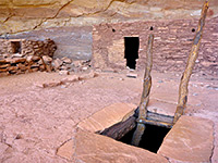 Length 6.7 miles (10.8 km); to Grand Gulch Elevation change 900 feet (274 meters) Difficulty Moderate - a few steep and rocky places Rating (1-5) ★★★★★ Large Grand Gulch tributary sheltering two significant Anasazi sites, Perfect Kiva Ruins and Jailhouse Ruins, together with several granaries. The lower end contains a flowing stream and has many good places for camping. |
9. Bullfrog Bay Canyon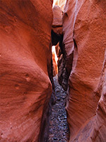 Length 0.5 miles (0.8 km) Elevation change 50 feet (15 meters) Difficulty Easy to moderate; a few dryfalls and other obstacles Rating (1-5) ★★★★★ Short, shallow, pebble-floored canyon leading to Bullfrog Bay on the north side of Lake Powell. Forms some pretty, narrow passageways through richly colored sandstone. |
10. Butler Canyon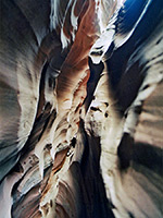 Length 4 miles (6.4 km); to explore the easy parts of the left and middle branches of the West Fork Elevation change 300 feet (91 meters) Difficulty Moderate to strenuous Rating (1-5) ★★★★★ Major tributary of North Wash with at least five upper forks that form very dark, narrow slot canyons, explorable from the top. The passages angle downwards quite steeply, requiring difficult downclimbing, and rappelling in some places, though as usual much can be seen without. These are however quite difficult canyons to traverse. |
11. Cave Spring Trail, Canyonlands National Park Length 0.6 miles (1 km); (loop) Elevation change 80 feet (24 meters) Difficulty Easy Rating (1-5) ★★★★★ The Cave Spring trail starts at the end of a spur road close to the Needles visitor center, and winds around a white sandstone plateau above the wide, bushy valley of Salt Creek. The easy route passes the spring, some pictographs, and various relics of an old cowboy camp that was inhabited from the late 1800s to about 1960. |
12. Cheesebox Canyon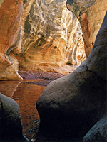 Length 8.5 miles (13.7 km); to see the upper slots, if walking from UT 95 Elevation change 1000 feet (305 meters) Difficulty Easy to moderate, depending how much of the upper narrows is explored Rating (1-5) ★★★★★ Lengthy White Canyon tributary leading deep into the wilderness; two forks totaling 15 miles, containing long slots with pools and drop offs, mostly in the upper sections. Further downstream are shorter narrows between wider passageways. |
13. Chesler Park Trail, Canyonlands National Park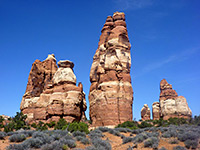 Length 3 miles (4.8 km); level overall Elevation change 0 feet (0 meters) Difficulty Moderate Rating (1-5) ★★★★★ This path passes varied terrain, across Elephant Canyon to the edge of Chesler Park - an unspoilt meadow ringed by the colorful, jagged rocks of the Needles. The first viewpoint is reached after 3 miles, from where another trail circles the edge of the meadow. One of several other routes radiating from the park is the Joint Trail, which winds southwards through cool, narrow passages between vertical rocks. |
14. Cistern and Ramp Canyons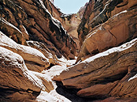 Length 8.1 miles (13 km); round trip, for the full loop Elevation change 500 feet (152 meters) Difficulty Moderate to strenuous - several chokestones to pass, one of which may need a rope Rating (1-5) ★★★★★ Pair of deep canyons through the steeply-angled rocks at the southwest edge of the Swell, forming short narrows sections containing a few pools and chokestones. The passageways are not very enclosed but quite dramatic. |
15. Comb Ridge and Butler Wash, Cedar Mesa, Grand Gulch and Comb Ridge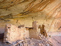 Length 0.2 miles (0.3 km); and upwards; many short hikes Elevation change 0 feet (0 meters) Difficulty Easy Rating (1-5) ★★★★★ Numerous petroglyphs, pictographs and Anasazi ruins, in short canyons on the east side of Comb Ridge, an exposed monocline. More sites are found along nearby Butler Wash, which parallels the ridge to the east |
16. Confluence Overlook Trail, Canyonlands National Park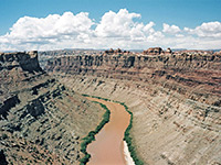 Length 5.5 miles (8.8 km) Elevation change 200 feet (61 meters) Difficulty Moderate Rating (1-5) ★★★★★ This excellent hike crosses several shallow canyons then traverses more open country, ending at a viewpoint of the junction of the Green and Colorado Rivers. The route is rather more strenuous than the average maintained NPS trail. |
17. Corona Arch Trail, Potash Road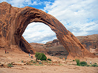 Length 1.5 miles (2.4 km) Elevation change 400 feet (122 meters) Difficulty Easy to moderate Rating (1-5) ★★★★★ Two contrasting sandstone arches are visited by this quite popular trail - enclosed, circular Bowtie Arch (a former pothole) and large, graceful, free-standing Corona Arch. The path also has good views over the Colorado River. |
18. Crack Canyon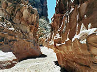 Length 2.3 miles (3.7 km); to the end of the narrows Elevation change 400 feet (122 meters) Difficulty Easy to moderate; several dryfalls to climb down Rating (1-5) ★★★★★ Three sections of angular narrows between more open sections, all likely to contain pools and mud. The surrounding rock is unusually varied in texture and color. Explorable as a short one-way hike or a longer loop through adjacent Chute Canyon, which has some less good narrows. |
19. Crawford Draw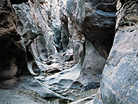 Length 1.5 miles (2.4 km); to the end of the best narrows Elevation change 200 feet (61 meters) Difficulty Easy to moderate - pools and dryfalls. Various entry/exit routes if needed Rating (1-5) ★★★★★ Upper tributary of Eardley Canyon, starting (via its own tributary, Reid Nelson Draw) with a photogenic section through fine stratified rock filled with long, semi-permanent pools, then a deeper stretch enclosed by spooky greyish rocks, followed by curvy potholes and then a gradually wider gorge that extends for many miles. |
20. Death Canyon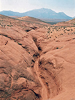 Length 1 mile (1.6 km) Elevation change 150 feet (46 meters) Difficulty Easy Rating (1-5) ★★★★★ Minor drainage joining the shallow upper part of North Wash, containing two dryfalls and a pool, above which are some shallow narrows. A good place to learn rappelling techniques, but most can easily be seen by regular hiking. |
21. Deer Canyon, Natural Bridges National Monument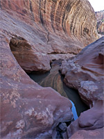 Length 3 miles (4.8 km); or longer Elevation change 500 feet (152 meters) Difficulty Moderate to strenuous Rating (1-5) ★★★★★ Deep, enclosed, west-side tributary of White Canyon containing pools, boulders, streaked cliffs and short sections of narrows; explorable by an off-trail hike |
22. Delicate Arch Trail, Arches National Park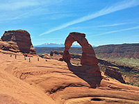 Length 1.5 miles (2.4 km) Elevation change 480 feet (146 meters) Difficulty Easy to moderate Rating (1-5) ★★★★★ The most famous feature in the park is reached by a popular trail that starts over sandy ground then climbs more steeply up rocky slopes to the edge of a sandstone bowl next to the arch. The base of the arch can be reached by walking a short distance over the slickrock. |
23. Delicate Arch Viewpoint, Arches National Park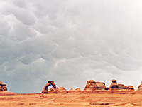 Length 0.25 miles (0.4 km) Elevation change 200 feet (61 meters) Difficulty Easy Rating (1-5) ★★★★★ For those not hiking all the way to Delicate Arch, a path to the south starts at the end of Wolfe Ranch Road and ascends moderately steeply to a viewpoint at the edge of the canyon of Winter Camp Wash, on the far side of which is the arch - about half a mile away above a sheer sandstone cliff streaked with desert varnish. |
24. Devils Canyon Length 4.8 miles (7.7 km); to the 3rd interesting tributary Elevation change 500 feet (152 meters) Difficulty Easy; only minor obstacles Rating (1-5) ★★★★★ Deep canyon with a few slot sections and miles of medium-width passageways through dull-colored sandstone, joined many narrow, branched but fairly shallow tributaries. In a little-visited region yet close to Interstate 70. |
25. Devils Garden Trail, Arches National Park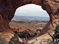 Length 7.5 miles (12.1 km); loop; level overall Elevation change 0 feet (0 meters) Difficulty Moderate Rating (1-5) ★★★★★ The longest trail in Arches National Park winds across slickrock and sand dunes through the largest area of arches situated away from the main road. The first 0.8 miles is graveled, and passes several large arches including Landscape, which has the widest span of all. Beyond here the route is a little rougher, and much less traveled. |
26. Ding and Dang Canyons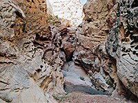 Length 6 miles (9.7 km); for the loop through both canyons Elevation change 500 feet (152 meters) Difficulty Easy to moderate - various chokestones to climb (one about 12 feet), and pools to wade Rating (1-5) ★★★★★ Two short ravines through the San Rafael Reef; quite narrow, though V-shaped and not enclosed, containing a selection of pools and chokestones. A good variety of rock textures en route. |
27. Double Arch Trail, Arches National Park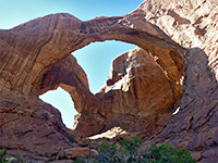 Length 0.25 miles (0.4 km) Elevation change 0 feet (0 meters) Difficulty Easy Rating (1-5) ★★★★★ As with most paths in the national park, the trail to the twin spans of Double Arch in the Windows section is quick and easy, starting from the parking area at the end of the spur road, and reaching the arch after a level walk through bushy, sandy land beneath the cliffs. |
28. Druid Arch Trail, Canyonlands National Park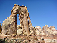 Length 5.4 miles (8.7 km) Elevation change 650 feet (198 meters) Difficulty Moderate Rating (1-5) ★★★★★ The double span of Druid Arch is a popular hiking destination, and is reached by the southernmost trail in the Needles, starting like several others from Elephant Hill. The route is south and later west across an open plateau, past one junction with an alternative approach from Squaw Flat, then through a narrow gap into the wide streambed of Elephant Canyon. Turning south (downstream), the trail passes three more junctions (west to Chesler Park, east to upper Squaw Canyon and west to the Joint Trail) and ends by climbing a short ladder right at the far end of the canyon, directly below the arch. |
29. Eardley Canyon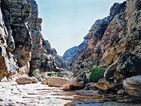 Length 5 miles (8 km); from Cliff Dweller Flat to the end of the enclosed section Elevation change 800 feet (244 meters) Difficulty Easy - no major obstacles before the potholes, but a long hike Rating (1-5) ★★★★★ Spectacular, hidden ravine; an upper narrows section through inclined limestone of many thin layers, becoming much deeper downstream - initially a dark, sheer-walled gorge then a larger, V-shaped canyon. Towards the lower end are several huge potholes that need ropes to pass, though they can be avoided by rim-walking. |
30. East Sevenmile Canyon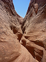 Length 3 miles (4.8 km); round trip, from the 4WD parking Elevation change 450 feet (137 meters) Difficulty Moderate - route finding, downclimbing Rating (1-5) ★★★★★ Short, branched ravine in a remote location on the north side of Lake Powell, near Bullfrog Marina - two forks with generally shallow narrows, both dropping steeply down to the water. As well as the narrows, the place is also notable for good views of the lake, here less than a quarter of a mile wide, enclosed by sheer cliffs and surrounded by vast expenses of slickrock. |
31. Farnsworth Canyon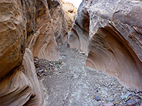 Length 2.7 miles (4.3 km); to the end of the narrows; 0.7 miles if driving the 4WD track Elevation change 80 feet (24 meters) Difficulty Easy Rating (1-5) ★★★★★ Short, moderately narrow drainage through angled, thin-layered rocks. No obstructions, so easily explored; reached by a dirt track off the road to Goblin Valley. |
32. Fisher Towers Trail, Fisher Towers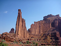 Length 2.2 miles (3.5 km) Elevation change 600 feet (183 meters) Difficulty Easy to moderate Rating (1-5) ★★★★★ The Fisher Towers are a series of vertical cliffs and pinnacles of red sandstone, eroded and grooved, rising above a landscape of hoodoos, terraces and narrow ravines. They may be explored by a winding trail around the base, ending at a fine viewpoint. |
33. Forgotten Canyon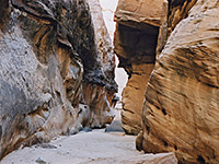 Length 1.8 miles (2.9 km); to the head of the narrows Elevation change 300 feet (91 meters) Difficulty Easy to moderate. Boulder piles and dryfalls to climb over Rating (1-5) ★★★★★ Short, moderately narrow but quite pretty slot towards the lower end of a much longer ravine, a tributary of Eagle Canyon on the west side of the Swell - a rarely visited region with pristine scenery. |
34. Fortknocker Canyon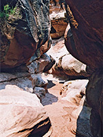 Length 4.4 miles (7.1 km); to the dryfall near White Canyon Elevation change 400 feet (122 meters) Difficulty Easy; a few chokestones and pools Rating (1-5) ★★★★★ Fairly shallow but scenic and colorful narrows in a rarely-visited east side tributary of White Canyon. The surrounding rocks often contain thin wide bands that form subtle, wavy patterns in the canyon walls. |
35. Fry Canyon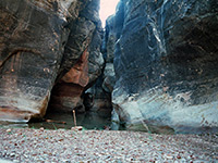 Length 1.8 miles (2.9 km); for the upper narrows, to the dryfall Elevation change 250 feet (76 meters) Difficulty Easy Rating (1-5) ★★★★★ The only major tributary of White Canyon on the west side; a short slot either side of the UT 95 bridge, followed by a wider section, then a dryfall into a deeper slot containing a permanent swimming pool. |
36. Gooseberry Trail and Monument Basin, Canyonlands National Park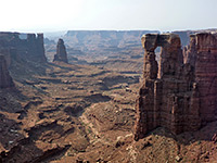 Length 4 miles (6.4 km); to Monument Basin Elevation change 1480 feet (451 meters) Difficulty Strenuous Rating (1-5) ★★★★★ Relatively short but initially very steep path, descending from the plateau near Grand View Point then following a shallow, rocky wash to the White Rim Road, at the brink of Gooseberry Canyon. A 1.3 mile continuation hike, mostly off-trail, reaches the rim of Monument Basin, for spectacular views of its red rock buttes and spires. |
37. Grand View Trail, Canyonlands National Park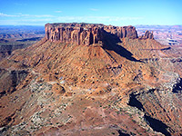 Length 1 mile (1.6 km) Elevation change level feet (0 meters) Difficulty Easy Rating (1-5) ★★★★★ The Grand View Trail leads from the carpark at the end of the park road to the very southern tip of the Island in the Sky plateau, at 6,265 feet, which offers a 270° panorama over the White Rim and the river canyons, the best view in the whole of Canyonlands National Park. |
38. Grandstaff Canyon, Moab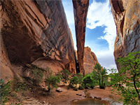 Length 2.6 miles (4.2 km) Elevation change 300 feet (91 meters) Difficulty Moderate Rating (1-5) ★★★★★ Popular route along a riparian, tree-lined, red rock ravine to a huge natural bridge - Morning Glory Arch - at the end of a short, narrow side canyon |
39. Gravel Canyon Length 3.9 miles (6.3 km); from Gravel Crossing upstream to the first big dryfall Elevation change 200 feet (61 meters) Difficulty Easy Rating (1-5) ★★★★★ The longest tributary of White Canyon - a relatively wide, sheer-walled gorge through grey-white sandstone, interrupted by many short narrow sections containing pools and drop offs. Most of the canyon is difficult to access by road but the lower few miles are reachable by hiking from UT 95 |
40. Herdina Park, Arches National Park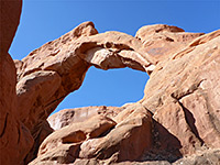 Length 4 miles (6.4 km); loop, circling all around the formations Elevation change 250 feet (76 meters) Difficulty Moderate Rating (1-5) ★★★★★ Isolated group of fins and ravines containing two major arches (Leaping Arch and Eye of the Whale), reached by a 4WD track. An unofficial, half mile trail leads to the arches, while more of the area can be seen by cross-country hiking, walking all around the edge of the formations. |
41. Hidden Valley Trail, Moab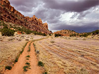 Length 2.5 miles (4 km) Elevation change 700 feet (213 meters) Difficulty Moderate; steep at the start Rating (1-5) ★★★★★ Path up a steep, boulder-covered slope with great views of Moab and the La Sal Mountains, then along the flat, grassy floor of a sheltered valley below red rock cliffs, to a major petroglyph site |
42. Hog Canyon Length 6 miles (9.7 km); round trip, to see the lower ends of the three upper forks Elevation change 500 feet (152 meters) Difficulty Easy Rating (1-5) ★★★★★ North Wash tributary containing a permanent stream, flowing mostly through a wide Wingate sandstone gorge, but three upper forks form very tight slots; as usual these can be seen fully if rappelling from the top, or partly by hiking from below. |
43. Holeman Slot Length 5.5 miles (8.8 km); via the Wilhite Trail Elevation change 1600 feet (488 meters) Difficulty Easy, after a long approach hike Rating (1-5) ★★★★★ Short narrows in Canyonlands National Park; a tributary of the Green River that forms 600 feet of pretty, light-colored, medium depth passageways, above an unclimbable dryfall and a wider lower gorge. |
44. Horseshoe Canyon Trail, Canyonlands National Park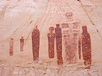 Length 3.25 miles (5.2 km) Elevation change 600 feet (183 meters) Difficulty Moderate Rating (1-5) ★★★★★ The remote Horseshoe Canyon section of Canyonlands National Park features four ancient Indian pictograph panels including the Great Gallery, a collection of several dozen figures reckoned to be the best rock art of its type anywhere on the Colorado Plateau. They may be visited by a moderately difficult trail. |
45. Joint Trail, Canyonlands National Park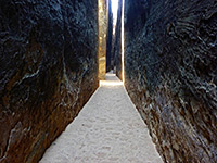 Length 4 miles (6.4 km); from the Elephant Hill Trailhead Elevation change 0 feet (0 meters) Difficulty Moderate Rating (1-5) ★★★★★ Unusual trail through a deep, narrow, vertical crevice, on the south side of Chesler Park. |
46. Kachina Bridge Trail, Natural Bridges National Monument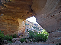 Length 0.7 miles (1.1 km) Elevation change 400 feet (122 meters) Difficulty Easy Rating (1-5) ★★★★★ The most geologically recent of the three natural bridges is Kachina, characterized by a relatively small opening beneath a very thick span, making the arch difficult to spot from the highway. The path to the bridge is the longest of the three so not as many people make the hike, despite it being quite easy. |
47. Lime Canyon, Cedar Mesa, Grand Gulch and Comb Ridge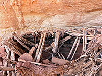 Length 8.7 miles (14 km); round trip, from Hwy 261 Elevation change 650 feet (198 meters) Difficulty Moderate; a few obstacles in the main canyon, and a traverse of steep slopes in the tributary Rating (1-5) ★★★★★ Major ravine on the east side of Cedar Mesa containing several Ancestral Puebloan ruins. Most are rather inaccessible, but one site in a tributary ravine is more easily reached and has several ancient structures, including a complete kiva |
48. Little Egypt, Little Egypt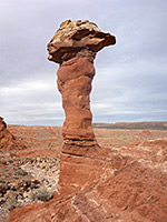 Length 1 mile (1.6 km); or less Elevation change 50 feet (15 meters) Difficulty Easy Rating (1-5) ★★★★★ Narrow band of eroded formations of red and white Entrada sandstone; a small-scale version of the more famous Goblin Valley to the north. The ridges and hoodoos extend about one mile along the base of a low mesa, easily viewed by a short hike from the access track. |
49. Little Ruin Canyon, Hovenweep National Monument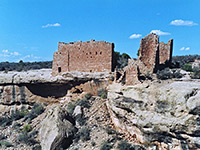 Length 1.5 miles (2.4 km); (loop) Elevation change 100 feet (30 meters) Difficulty Easy Rating (1-5) ★★★★★ The main trail in Hovenweep National Monument winds up and down two forks of a shallow, sheer-walled canyon of Dakota sandstone, passing at least ten ruins. Most impressive is Hovenweep Castle, which has several rooms and D-shaped towers built right on the canyon rim. |
50. Little Wild Horse Canyon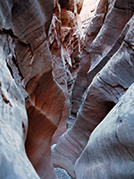 Length 1.8 miles (2.9 km); to the upper end of the narrows Elevation change 400 feet (122 meters) Difficulty Easy to moderate - small potholes and a few chokestones Rating (1-5) ★★★★★ Most visited location in the Swell - a long, very narrow slot canyon through nicely colored rocks, easily accessed and not difficult to explore. One hour is enough to see the best sections along its lower end, although the usual plan is to combine a tour with neighboring Bell Canyon, for a 8 mile loop that in addition to the two narrow gorges also passes high, colorful cliffs and much interesting exposed, eroded rock. |
51. Long Canyon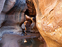 Length 5.3 miles (8.5 km); from Gravel Crossing to the first slot canyon tributary Elevation change 400 feet (122 meters) Difficulty Easy to moderate; pools and dryfalls Rating (1-5) ★★★★★ East side White Canyon tributary extending for ten miles across a sandstone plateau, and containing short slots with pools and dryfalls, between more extensive, less enclosed sections, but often still with water and minor obstacles. Several forks also have narrows. The lower end is suitable for day hiking. |
52. Loop Trail, Dead Horse Point State Park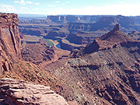 Length 5.5 miles (8.8 km); (loop) Elevation change 160 feet (49 meters) Difficulty Easy to moderate; lacks shade Rating (1-5) ★★★★★ The only extended hike in the state park; a combination of the East Rim and West Rim trails, visiting four named overlooks, of Shafer Canyon and the Colorado River. All of the route is essentially flat, though generally lacking shade so the hike can be quite testing during the heat of summer, despite the gentle terrain. |
53. Lower Big Spring Canyon, Canyonlands National Park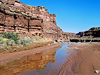 Length 5 miles (8 km) Elevation change 500 feet (152 meters) Difficulty Moderate Rating (1-5) ★★★★★ Cross country route down a scenic canyon to a viewpoint of the Colorado River - initially along the streambed, until it descends via some sheer dryfalls, then on a bench on the south side. |
54. Lower Elephant Canyon, Canyonlands National Park Length 5 miles (8 km) Elevation change 800 feet (244 meters) Difficulty Moderate Rating (1-5) ★★★★★ Narrow, deepening canyon that provides a route to the Colorado River; hike is along the Confluence Trail for a mile, then down the streambed, and finally across sloping terrain to a viewpoint high above the river. |
55. Lower Fish Creek, Cedar Mesa, Grand Gulch and Comb Ridge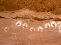 Length 5 miles (8 km); to the tenth site Elevation change 250 feet (76 meters) Difficulty Easy to moderate - thick undergrowth in a few places, some stream crossings Rating (1-5) ★★★★★ East-side Cedar Mesa canyon with a permanent stream draining into Comb Wash, containing about ten ancient sites including granaries, ruined settlements, pictographs and petroglyphs. Quite overgrown and not often visited |
56. Lower Mule Canyon, Cedar Mesa, Grand Gulch and Comb Ridge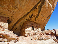 Length 1 mile (1.6 km) Elevation change 100 feet (30 meters) Difficulty Easy Rating (1-5) ★★★★★ Downstream end of a long drainage on the east side of Cedar Mesa, containing several groups of Anasazi ruins, easily accessed from Comb Wash Road. The sites are small but attractively situated in sandstone alcoves. |
57. Maidenwater Canyon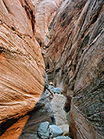 Length 2.8 miles (4.5 km); downstream to Trachyte Creek; ca 1 mile to hike up the lower end of the slot west of the highway Elevation change 350 feet (107 meters) Difficulty Moderate - various obstacles in the lower canyon; pools and upclimbing in the upper slot Rating (1-5) ★★★★★ Maidenwater Canyon is a Trachyte Creek tributary that forms mostly shallow narrows downstream (east of UT 276), containing pools, chokestones and running water, while upstream (west of UT 276) is a much deeper and tighter slot, the lower end of which can be seen by hiking. Ropes are needed to go all the way through. |
58. Manns Peak Trail, La Sal Mountains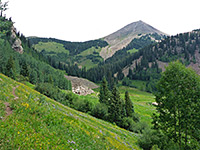 Length 3.7 miles (6 km); from Geyser Pass Elevation change 1830 feet (558 meters) Difficulty Moderate Rating (1-5) ★★★★★ Varied trail to the fifth highest summit in the La Sal Mountains, encountering meadows, aspen groves, pine woodland, scree and tundra; wide-ranging views along the latter stages. |
59. Mesa Arch Trail, Canyonlands National Park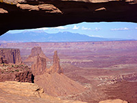 Length 0.6 miles (1 km); (loop) Elevation change level feet (0 meters) Difficulty Easy Rating (1-5) ★★★★★ A short, easy route through pine-juniper woodland to Mesa Arch, perched on the east rim of the plateau high above the middle fork of Buck Canyon. The view through the arch, looking out towards the distant and often snow-covered La Sal Mountains, is one of the most photographed in the park, especially at sunrise. |
60. Moonshine Wash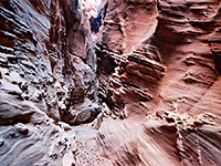 Length 7 miles (11.3 km); round trip, down the main fork and partly back up the west fork Elevation change 300 feet (91 meters) Difficulty Moderate - chokestones and muddy pools Rating (1-5) ★★★★★ Beautiful, extensive narrows through colorful, thin-layered, nicely eroded sandstone, in a remote area of the San Rafael Desert. The gorge becomes a box canyon below the slot, and eventually joins the San Rafael River. |
61. Mount Ellsworth, Henry Mountains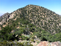 Length 3.4 miles (5.5 km) Elevation change 2870 feet (875 meters) Difficulty Strenuous Rating (1-5) ★★★★★ Higher of the two peaks in the Little Rockies, the southern component of the Henry Mountains, reached by a sparsely cairned, off-trail route up ridges and steep slopes on the northwest side. Spectacular views from the summit |
62. Muddy Creek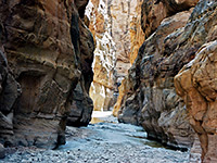 Length 9 miles (14.5 km); from the north, to the end of the narrows Elevation change 450 feet (137 meters) Difficulty Easy to moderate; no obstructions, but a long hike, often through sticky mud Rating (1-5) ★★★★★ Deepest canyon in the Swell, containing a stream most of the year, flowing through 3 miles of narrows ('The Chute'), resembling some of the canyons in Zion National Park. |
63. Murphy Point Trail, Canyonlands National Park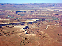 Length 1.7 miles (2.7 km) Elevation change 0 feet (0 meters) Difficulty Easy Rating (1-5) ★★★★★ Murphy Point is a narrow mesa on the west side of the Island in the Sky, and can be reached by an old vehicle track, now for foot travel only, that leaves the park road a little way north of Buck Canyon Overlook. The western edge looks out over a vast area of canyons and mesas, including Soda Springs Basin, the White Rim, and Murphy Hogback - a westwards continuation of the main mesa 1,000 feet lower down. Along the track begins the 10 mile Murphy Loop Trail, which descends steeply down the south side of the point and follows the hogback, meeting a primitive campsite beside the White Rim road and returning via a parallel ravine a short distance to the south. |
64. Music Canyon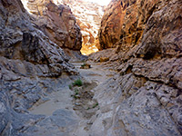 Length 4 miles (6.4 km); to the first unclimbable dryfall Elevation change 1000 feet (305 meters) Difficulty Easy, to the dryfall Rating (1-5) ★★★★★ East side tributary of Muddy Creek, deep and enclosed for just over a mile, and containing three sheer drops where ropes are needed. The upper narrows are moderately scenic, reached by quite a long hike. |
65. Neck Spring Trail, Canyonlands National Park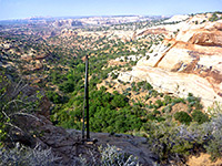 Length 5 miles (8 km); (loop) Elevation change 260 feet (79 meters) Difficulty Moderate - a few short, steep sections Rating (1-5) ★★★★★ The well used, 5 mile trail past Neck Spring starts just south of the visitor center, opposite Shafer Canyon overlook, and winds around some upper tributaries of Taylor Canyon, also passing Cabin Spring and various old cattle ranching relics. The trail has good views westwards, towards the Green River. |
66. North Fork of Iron Wash Length 10.5 miles (16.9 km); for a loop to both ends of the narrows Elevation change 600 feet (183 meters) Difficulty Moderate; cross country hiking, potholes in the slot Rating (1-5) ★★★★★ Remote, scenic, technical slot, the upper end of which can be seen without rappelling, though it still contains some deep potholes, and needs a long cross-country walk to reach. Another possible hike is to the enclosed chamber at the lower end of the slot. |
67. North Fork of Maidenwater Canyon Length 2.5 miles (4 km); to the lower end of the slot Elevation change 600 feet (183 meters) Difficulty Easy to see the upper and lower parts; strenuous downclimbing in the middle Rating (1-5) ★★★★★ Minor tributary joining the north side of Maidenwater Canyon, near the junction with Trachyte Creek; shallowish slots in the middle, with several sloping dryfalls. Also a short, tight side canyon. |
68. North Fork of Mule Canyon, Cedar Mesa, Grand Gulch and Comb Ridge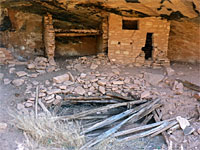 Length 2.8 miles (4.5 km); to the fourth site Elevation change 200 feet (61 meters) Difficulty Easy to moderate Rating (1-5) ★★★★★ Relatively shallow and lightly vegetated canyon containing at least four groups of ancient ruins, some with rock art. Two are close to the streambed; the other pair are high above, and harder to reach |
69. North Trachyte Point Canyon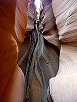 Length 8 miles (12.9 km); round trip, if starting from UT 276 Elevation change 300 feet (91 meters) Difficulty Easy to moderate; cross-country navigation, and stemming in the narrows Rating (1-5) ★★★★★ East-side tributary of Trachyte Creek, not generally narrow apart from one short section near the lower end, but some of the enclosed passages are quite colorful, with pretty rock textures. Known as Munchkin Canyon. Accessed either from Hwy 276 or by driving along a rough track towards Trachyte Point. |
70. North Wash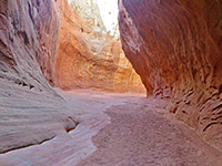 Length 6 miles (9.7 km); for four separate hikes into the accessible parts of the lower ends of the canyons Elevation change 200 feet (61 meters) Difficulty Moderate - tight narrows, muddy pools, chokestones Rating (1-5) ★★★★★ Four popular slot canyon tributaries on the northeast side of North Wash, easily accessed by short walks from UT 95, and increasing in difficulty from west to east. All need rappelling to descend fully but parts of the westernmost three are explorable by regular hiking. |
71. Owachomo Bridge Trail, Natural Bridges National Monument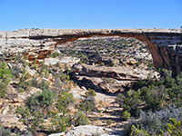 Length 0.2 miles (0.3 km) Elevation change 90 feet (27 meters) Difficulty Easy Rating (1-5) ★★★★★ Owachomo Bridge may be viewed by a quick hike along an easy trail down a fairly gentle slope starting at the roadside viewpoint, ending at a slickrock bowl directly beneath, at the edge of Armstrong Canyon which runs past on the north side. |
72. Park Avenue Trail, Arches National Park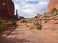 Length 1 mile (1.6 km) Elevation change 320 feet (98 meters) Difficulty Easy Rating (1-5) ★★★★★ A popular route through a short canyon framed by red sandstone fins and pinnacles, containing a rocky streambed that may have pools or even flowing water. Passes close to several famous landmarks including The Organ and the Three Gossips. Each end of the route has a parking area, adjacent to the park road. |
73. Peekaboo Trail, Canyonlands National Park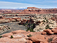 Length 5 miles (8 km) Elevation change 270 feet (82 meters) Difficulty Moderate; relatively long, but most is fairly level Rating (1-5) ★★★★★ Path over grassy flats, two canyons (Squaw and Lost) and high sandstone benches, ending with a descent to the larger drainage of Salt Creek, meeting the 4WD route through that canyon, beside a spring and pictograph panel |
74. Pothole Point Trail, Canyonlands National Park Length 0.6 miles (1 km); loop Elevation change level feet (0 meters) Difficulty Easy Rating (1-5) ★★★★★ Pothole Point is renowned for its pretty reflective pools that form after rainfall, filling depressions in the flat Cedar Mesa sandstone rock. The easy, cairned path circles around a small mesa and also has good views over the Needles formations and Big Spring Canyon. If hiking right after rains there will be hundreds of potholes and pools, the largest up to 10 meters across. The holes form because of slightly softer patches in the rock, and enlarge due to erosion and acid in the accumulated rainwater. |
75. Professor Creek Length 4 miles (6.4 km); to the 15 foot chokestone Elevation change 600 feet (183 meters) Difficulty Easy to the chokestone; moderate if exploring above Rating (1-5) ★★★★★ Permanent stream flowing along a shallow but pretty canyon, narrow for nearly 2 miles, through colorful reddish rocks. The walls have interesting textures and colors, different to most true slot canyons as the sandstone is darker, harder and less striated. The hike upstream is an easy walk, and very pleasant in summer as much of the journey involves paddling in the cool, shallow water. |
76. Red Lake Canyon Trail, Canyonlands National Park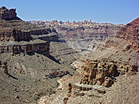 Length 9.5 miles (15.3 km) Elevation change 1600 feet (488 meters) Difficulty Strenuous Rating (1-5) ★★★★★ The only direct route to the Colorado River in the Needles is along Lower Red Lake Canyon, 2 miles south of the confluence with the Green River. The path begins along the Devils Lane road, just east of Cyclone Canyon, a point reached either by hiking from Big Spring Canyon Overlook, or (slightly shorter) by 4WD vehicle or on foot starting from the Elephant Hill trailhead. Lower Red Lake is a deep, overgrown, rocky but quite short canyon, without any obstructions, that meets the Colorado just upstream of the start of the rapids in Cataract Canyon. The round trip to the river is normally done over 2 days. |
77. Rock Canyon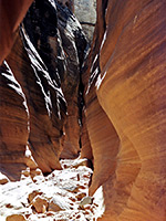 Length 5 miles (8 km); to see the upper and lower narrows Elevation change 300 feet (91 meters) Difficulty Easy to moderate; at least one dryfall to climb Rating (1-5) ★★★★★ Fairly short, north-side tributary of the Colorado River/upper Lake Powell; a good deep slot giving way to shallower, less enclosed narrows, before a high dryfall near the river. |
78. Sand Dune Arch Trail, Arches National Park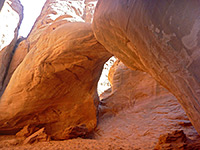 Length 0.2 miles (0.3 km) Elevation change 0 feet (0 meters) Difficulty Easy Rating (1-5) ★★★★★ Sand Dune is a somewhat hidden arch at the north edge of the Fiery Furnace region, reached by a short spur trail leading off the loop path to Broken Arch. |
79. Sheiks Canyon, Cedar Mesa, Grand Gulch and Comb Ridge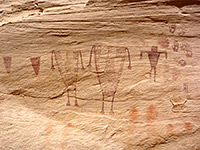 Length 3 miles (4.8 km); to Grand Gulch Elevation change 800 feet (244 meters) Difficulty Moderate - a few steep and rocky places Rating (1-5) ★★★★★ Short tributary of Grand Gulch containing several Anasazi dwellings including Yellow House Ruins and Green Mask Ruins, plus pictographs, petroglyphs, carvings, and fine canyon scenery. |
80. Sipapu Bridge Trail, Natural Bridges National Monument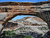 Length 0.6 miles (1 km) Elevation change 500 feet (152 meters) Difficulty Easy to moderate Rating (1-5) ★★★★★ Sipapu is the biggest bridge in terms of height and span, and the most impressive when viewed from below. The path descends steeply to the canyon floor; the half mile journey is somewhat strenuous, and has some parts where ladders are installed to traverse vertical cliffs, yet the trail is popular since the bridge is the first along the park road, and arguably the best. One mile downstream, a continuation path reaches the Anasazi dwellings of Horse Collar Ruin. |
81. Skyline Arch Trail, Arches National Park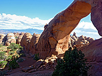 Length 0.2 miles (0.3 km) Elevation change 0 feet (0 meters) Difficulty Easy Rating (1-5) ★★★★★ Situated on top of a ridge near the north end of the scenic drive, Skyline Arch can easily be seen from the road, but the short, easy trail leading to its base offers much better views. A different, higher elevation perspective is from behind the arch, via another short path starting from Devils Garden Campground. |
82. Slickhorn Canyon, Cedar Mesa, Grand Gulch and Comb Ridge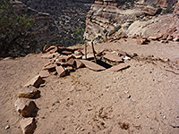 Length 2.5 miles (4 km); to Perfect Kiva Elevation change 800 feet (244 meters) Difficulty Moderate - a few steep and rocky places Rating (1-5) ★★★★★ San Juan River tributary with four relatively short upper forks, all containing Anasazi ruins and pictographs, explorable on day hikes. Most famous site is Perfect Kiva Ruin, featuring an intact kiva with undamaged roof. |
83. Slickrock Foot Trail, Canyonlands National Park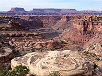 Length 2.4 miles (3.9 km); (loop) Elevation change 80 feet (24 meters) Difficulty Easy Rating (1-5) ★★★★★ Starting near the end of the scenic drive at Big Spring Canyon, the mostly level Slickrock Foot Trail loops around a sandstone plateau, with 4 short spurs to overlooks of Big and Little Spring canyons and excellent views across the whole Needles area towards distant mountains. |
84. Smith Fork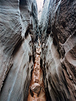 Length 7.5 miles (12.1 km); to Lake Powell (less 3 miles if driving to the end of the track) Elevation change 500 feet (152 meters) Difficulty Easy to moderate in the main canyon - several obstructions to climb over Rating (1-5) ★★★★★ Good narrows through Navajo sandstone, in a secluded, rarely visited drainage leading to Lake Powell. Six east-side tributaries also form short slots, some very testing to explore. The lower end of the canyon opens out into a cliff-bound, cottonwood-lined wash and eventually meets the lake. |
85. South Fork of Mule Canyon, Cedar Mesa, Grand Gulch and Comb Ridge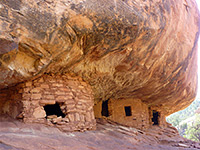 Length 4.3 miles (6.9 km) Elevation change 250 feet (76 meters) Difficulty Easy Rating (1-5) ★★★★★ Fairly shallow, level and easily explored canyon close to UT 95, containing at least eight groups of ruins, some quite large and intricate. A path runs most of the way, merging with the streambed towards the upper end. |
86. Squaw Canyon and Lost Canyon, Canyonlands National Park Length 8.7 miles (14 km); (loop) Elevation change 400 feet (122 meters) Difficulty Moderate Rating (1-5) ★★★★★ This loop hike explores two adjacent canyons that are quite different in character. If walking clockwise, the first part is the same route used to reach Peekaboo Spring, as far as Lost Canyon, where a right turn leads along this densely-vegetated, watery drainage to its upper end, then over a high ridge on the west side into Squaw Canyon, which has no stream so is much more arid and open. The Peekaboo Trail is rejoined after a 1.6 mile walk down this ravine, then the trailhead is 1.1 miles further. |
87. Steer Gulch, Cedar Mesa, Grand Gulch and Comb Ridge Length 8 miles (12.9 km); round trip Elevation change 400 feet (122 meters) Difficulty Easy to moderate; a few obstacles to pass Rating (1-5) ★★★★★ Long, treeless, mostly shallow canyon with occasional pools, narrow passageways and fluted slickrock channels. Two forks towards the upper end may be explored by a cross-country loop hike starting from Hwy 276 |
88. Sundance Trail, Dark Canyon Length 3 miles (4.8 km) Elevation change 1120 feet (341 meters) Difficulty Moderate to strenuous Rating (1-5) ★★★★★ The easiest Dark Canyon entry route, descending via a steep-sided ravine into one of the deepest sections of the gorge towards the lower end, opposite Lean-To Canyon. This lengthy, deep, branched canyon complex has otherwise difficult access, and extends from desert-like land beside the Colorado River to the wooded slopes of the Abajo Mountains at over 8,000 feet. |
89. Swett Creek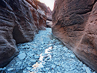 Length 7.4 miles (11.9 km); to Trachyte Creek Elevation change 800 feet (244 meters) Difficulty Easy; no major obstructions Rating (1-5) ★★★★★ The southernmost Trachyte Creek tributary; a long drainage that forms shallow narrows in the upper section, giving way to a deeper gorge lower down, also containing a few slot-like passages. |
90. Syncline Loop Trail, Canyonlands National Park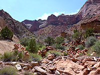 Length 8 miles (12.9 km); (loop) Elevation change 1460 feet (445 meters) Difficulty Strenuous Rating (1-5) ★★★★★ Varied circuit of the two curving canyons either side of Upheaval Dome - the steep, exposed Upheaval Valley to the south and the longer, more overgrown Syncline Valley to the north, which contains a few springs. The dome itself can be seen via a separate hike, mostly along a stony streambed - up to another 4 miles. |
91. Todie Canyon, Cedar Mesa, Grand Gulch and Comb Ridge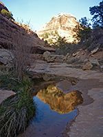 Length 2 miles (3.2 km); to the Grand Gulch confluence Elevation change 600 feet (183 meters) Difficulty Moderate to strenuous; steep, rocky and overgrown Rating (1-5) ★★★★★ Relatively short but steeply sloping ravine used as a route to Grand Gulch; contains a shallow stream towards the lower end and a few inaccessible ruins, high up on benches. |
92. Trachyte Creek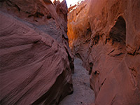 Length 6 miles (9.7 km); round trip; down the north fork and up the main canyon Elevation change 300 feet (91 meters) Difficulty Easy Rating (1-5) ★★★★★ Long, branched drainage holding a permanent stream; a section of the upper canyon has an enclosed section with waterfalls, while a north fork forms shallow narrows through nicely colored rocks. |
93. Trachyte Point Canyon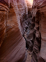 Length 10 miles (16.1 km); round trip, starting from UT 276 Elevation change 600 feet (183 meters) Difficulty Moderate; downclimbing and cross-country navigation Rating (1-5) ★★★★★ One of over a dozen east side tributaries of Trachyte Creek, south of Trachyte Point, including half a mile of colorful narrows, interrupted by a few high falls that need rappelling, but easily explorable above and below. Known as Witches Cauldron, or Trachyotomy |
94. Trail Canyon Length 0.6 miles (1 km); to the unclimbable narrows Elevation change 200 feet (61 meters) Difficulty Easy to moderate; a few lesser obstacles in the lower canyon Rating (1-5) ★★★★★ Tributary of Trachyte Creek; the upper north fork forms tight narrows through smooth, orange-red rocks, containing several sheer drops where ropes are needed (when exploring from the top), but a reasonable amount of the lower end is accessible by hiking. |
95. Tributaries of Poison Spring Canyon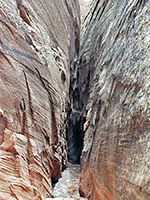 Length 7 miles (11.3 km); round trip, to explore the various branches from the lower ends Elevation change 400 feet (122 meters) Difficulty Easy, for the walk-in sections Rating (1-5) ★★★★★ Branched canyon, generally quite wide, with several upper forks that form short, deep, steeply-sloping slots though the Navajo sandstone of Cedar Point. Ropes are needed to explore the narrows fully, but some parts are easily accessible. There are also a few potentially interesting tributaries on the north side of the main ravine, and others further downstream. |
96. Tuwa Canyon, Natural Bridges National Monument Length 6.5 miles (10.5 km); round trip Elevation change 560 feet (171 meters) Difficulty Moderate; various pools and dryfalls to pass Rating (1-5) ★★★★★ Relatively shallow tributary of Armstrong Canyon, joining just below Owochomo Bridge; upstream it splits into two forks, extending outside the national monument. Both contain pools and pour-offs, and may be explored via an off-trail hike |
97. Upheaval Dome Overlook Trail, Canyonlands National Park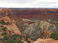 Length 1 mile (1.6 km) Elevation change 200 feet (61 meters) Difficulty Easy Rating (1-5) ★★★★★ Upheaval Dome is a large crater at the west side of the plateau, thought to result from meteoric impact. An easy trail leads to two viewpoints along the south rim, and a nearby cross-country route descends Upheaval Canyon to the Green River. |
98. West Fork Johns Canyon, Cedar Mesa, Grand Gulch and Comb Ridge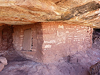 Length 4 miles (6.4 km); or more; round trip Elevation change 400 feet (122 meters) Difficulty Moderate; some climbing needed to reach the ruins Rating (1-5) ★★★★★ Johns Canyon is a large, branched drainage on the south side of Cedar Mesa. The main West Fork contains two groups of ruins near its upper end, in alcoves high above the canyon floor. Walking through the canyon is relatively straightforward as it is not particularly steep or overgrown, but the two groups are high above the floor, close to the mesa rim, and the routes up may not be obvious. |
99. White Canyon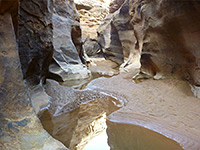 Length 5 miles (8 km); between the two trailheads (plus another 1.5 miles along the road) Elevation change 400 feet (122 meters) Difficulty Easy to moderate for most of the canyon; strenuous if swimming through the Black Hole Rating (1-5) ★★★★★ Major drainage running for over 30 miles alongside UT 95; moderately narrow for most of its length and forming several slot sections, in particular the permanently flooded Black Hole. May have long pools in many other places, as the canyon channels a great amount of water after rainfall. |
100. White Canyon, Natural Bridges National Monument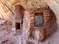 Length 3.6 miles (5.8 km) Elevation change 500 feet (152 meters) Difficulty Moderate Rating (1-5) ★★★★★ Hike upstream along White Canyon, starting at Sipapu Bridge, alongside a near-permanent stream with pools and cascades, to four groups of Ancestral Puebloan ruins, including rock art panels. The ruins are not much publicized and as a result are infrequently visited, yet they are easy enough to reach, if not always straightforward to locate, and some time is necessary is to see all sections, hence the hike takes a relatively long time. |
101. White Rim Overlook Trail, Canyonlands National Park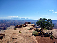 Length 0.9 miles (1.4 km) Elevation change 140 feet (43 meters) Difficulty Easy Rating (1-5) ★★★★★ The White Rim can be seen from every high elevation viewpoint in the Island in the Sky, but best of all from the end of a very narrow promontory that projects eastwards, off the main plateau, a mile north of Grand View Point. The largest, flattest area of the rim is far below just to the east, while also in fine view are Monument Basin and Gooseberry Canyon. |
102. Wildcat Trail, Monument Valley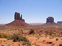 Length 3.2 miles (5.1 km); round trip Elevation change 350 feet (107 meters) Difficulty Easy Rating (1-5) ★★★★★ Rare opportunity to hike in Monument Valley; a mostly level loop all around West Mitten Butte, across sand dunes and along dry washes, with good views of the neighboring cliffs and pinnacles. |
103. Wilhite Trail, Canyonlands National Park Length 5 miles (8 km) Elevation change 1600 feet (488 meters) Difficulty Moderate to strenuous Rating (1-5) ★★★★★ The Wilhite Trail is another that descends the sheer Wingate Cliffs that encircle the Island-in-the Sky, then follows a shallow, red rock canyon to the White Rim road. The route begins half way along the spur road to Upheaval Dome, at first crossing brush-covered flat land at the edge of the mesa, before descending 1,000 feet quite steeply down a narrow ravine into Holeman Spring Basin. The path then follows a streamway through the wide, open basin, joining the White Rim road about half a mile from the Green River. On the far side of the road the Holeman Spring drainage forms a short slot canyon, though a sheer pour-off prevents continuing all the way to the river. |
All Contents © Copyright The American Southwest | Comments and Questions | Contribute | Affiliate Marketing Disclosure | Site Map