Arch Canyon
Northeastern Cedar Mesa canyon containing a large cliff dwelling ruin near its lower end, with pictographs and petroglyphs, while upstream are several smaller ancient sites, mostly high above the streambed. The canyon extends 14 miles in total, and has several arches in its upper reaches
Length: 0.4 miles to the large ruin, 2.5 miles to the first high-level ruin
Elevation change: 170 feet, to the high level ruin
Difficulty: Easy
Type: One way, along a 4WD track
Usage: Low
Season: Spring, summer, fall; affected by snow in the winter
Trailhead: 2.5 miles along a dirt track, off Hwy 95. 4WD vehicles can drive closer
Rating (1-5): ★★★★★
Elevation change: 170 feet, to the high level ruin
Difficulty: Easy
Type: One way, along a 4WD track
Usage: Low
Season: Spring, summer, fall; affected by snow in the winter
Trailhead: 2.5 miles along a dirt track, off Hwy 95. 4WD vehicles can drive closer
Rating (1-5): ★★★★★

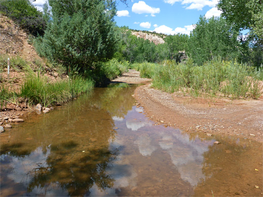
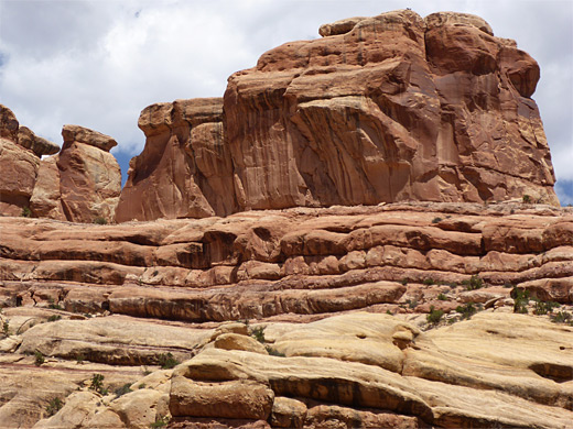
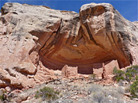
Arch Canyon is one of the northernmost of the Cedar Mesa canyons, on the north side of Hwy 95; it begins in the Abajo Mountain foothills below South Elk Ridge, elevation around 7,000 feet, within the La Sal National Forest. Ponderosa pines grow in the upper reaches, which contain several arches, but the lower end is desert-like, more typical of this region, and the elevation has dropped by 2,000 feet at the point where the canyon opens out, and its small but permanent stream meets Comb Wash, below the steep west face of Comb Ridge.
The drainage is 14 miles in length, and largely free of obstructions, allowing a 4WD track to follow the creekbed for 8 miles upstream, as far as the junction with Texas Canyon, from where trails continue, up these two branches and also into another tributary (Butts Canyon), so several days could be spent exploring, but most people see only the lowest section, as here are found several ancient ruins of which the first is by far the largest, set at the foot of a tall cliff streaked with desert varnish and adorned with much rock art. Other ruins, less visited, are scattered upcanyon for another five miles or so but apart from a small structure also close the streambed, they are high on inaccessible benches, glimpsed only from a distance.
Guidelines for visiting archaeological sites
Map of Cedar Mesa, Grand Gulch and Comb Ridge.
25 views of Arch Canyon.
The mouth of Arch Canyon is reached by (unpaved) road 229, forking northwards off Hwy 95; on the opposite side, a short distance along another track, is a primitive camping area, useful since camping is not permitted on the canyon road as it enters part of the Ute Reservation. This track crosses bushy terrain, guarded by fences and No Trespassing notices, past three much smaller canyons and, after turning right at a minor junction, fords the Arch Canyon streambed. 2WD vehicles should be parked here while 4WD may continue up the canyon along a sandy track which branches off to the northwest, just before the wash crossing. Also nearby, on the south side of the first junction, is a corral and a few iron relics, marking the site of an abandoned homestead, Perkins Ranch.
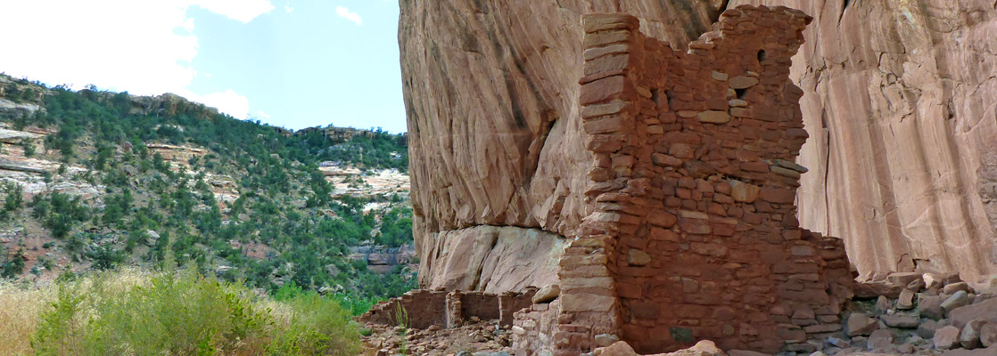
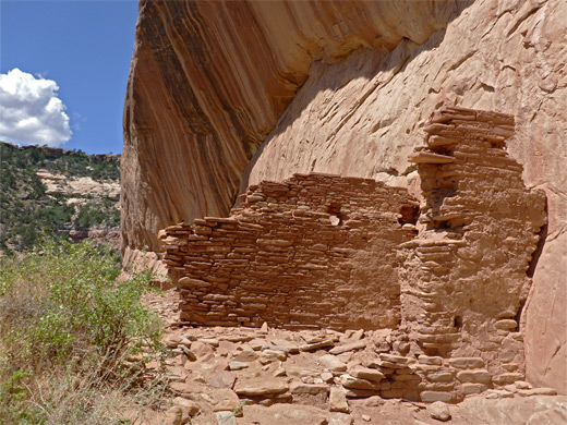
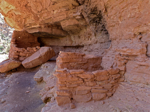
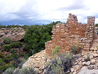
The sandy track follows the creek towards the mouth of the canyon, through an overgrown riparian corridor with reeds and grass up to eight feet tall, alongside a low cliff and into a more open area, then over the stream for the first time to the main ruin, 0.4 miles from the 2WD trailhead. The canyon walls have risen quickly, becoming 500 feet high in less than a quarter of a mile. The site is enclosed by a fence, perhaps to keep animals away, with an entrance on the right side, next to an old sign and a more recent BLM notice. The ruin lies at the foot of a tall, streaked, slightly overhanging, south-facing cliff of Cedar Mesa Sandstone and is in full sun much of the day, not shaded like many other ruins hereabouts.
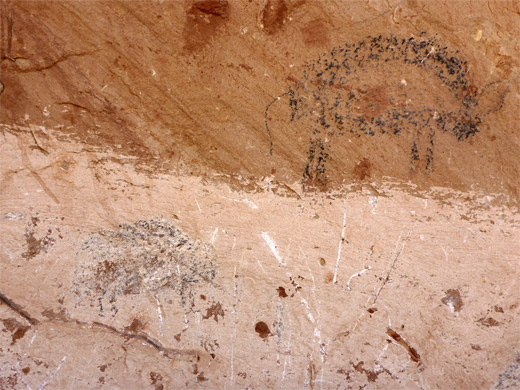
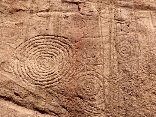
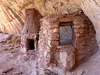
The pueblo consists of one large structure and several smaller rooms, together extending over 300 feet, while on the cliff are a small number of pictographs, including some black bison, and many petroglyphs, mostly spirals and other geometric figures. Many of the designs are rather faint, though for some this is due to surface coatings, presumably deposited by rainwater washing down the cliffs, rather than weathering. Post holes and rock art some distance above ground indicates existence of high-level rooms, on two or even three stories. Several smaller structures, and more petroglyphs, can be found beyond the fenced-off area, around a corner, where the cliff bends to the north.
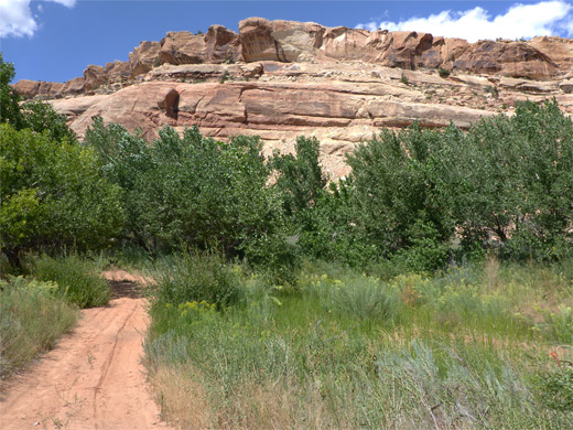
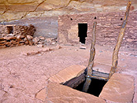
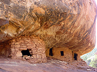
The continuation track is much less used by vehicles. It passes back to the south side of the stream, later followed by two more crossings in quick succession, after which the vegetation lessens somewhat and the canyon becomes more open, the stream more likely to be dry. The next ruin, 1.3 miles from the start, is also on the north side, overlooking the tree-lined junction of a minor tributary; this structure has two components, one incorporating a neat doorway, and is built on a shady ledge around 30 feet above the streambed. There are no more ruins for about a mile, by which time, after several bends, the canyon opens out and is fairly straight, then just after a projecting ridge topped with several pinnacles is a high level group of ruins on the north side along an extensive bench at the foot of a big cliff, seemingly impossible to reach from creek level. This location is just before the junction of a much bigger north-side tributary and it seems a suitable turnaround place, for a half day hike. The canyon does have other ancient sites, over the next few miles, but all seem to be high up and out of reach.
The drainage is 14 miles in length, and largely free of obstructions, allowing a 4WD track to follow the creekbed for 8 miles upstream, as far as the junction with Texas Canyon, from where trails continue, up these two branches and also into another tributary (Butts Canyon), so several days could be spent exploring, but most people see only the lowest section, as here are found several ancient ruins of which the first is by far the largest, set at the foot of a tall cliff streaked with desert varnish and adorned with much rock art. Other ruins, less visited, are scattered upcanyon for another five miles or so but apart from a small structure also close the streambed, they are high on inaccessible benches, glimpsed only from a distance.
Guidelines for visiting archaeological sites
Location
Map of Cedar Mesa, Grand Gulch and Comb Ridge.
Photographs
25 views of Arch Canyon.

Access to Arch Canyon
The mouth of Arch Canyon is reached by (unpaved) road 229, forking northwards off Hwy 95; on the opposite side, a short distance along another track, is a primitive camping area, useful since camping is not permitted on the canyon road as it enters part of the Ute Reservation. This track crosses bushy terrain, guarded by fences and No Trespassing notices, past three much smaller canyons and, after turning right at a minor junction, fords the Arch Canyon streambed. 2WD vehicles should be parked here while 4WD may continue up the canyon along a sandy track which branches off to the northwest, just before the wash crossing. Also nearby, on the south side of the first junction, is a corral and a few iron relics, marking the site of an abandoned homestead, Perkins Ranch.
Start of the Track
The sandy track follows the creek towards the mouth of the canyon, through an overgrown riparian corridor with reeds and grass up to eight feet tall, alongside a low cliff and into a more open area, then over the stream for the first time to the main ruin, 0.4 miles from the 2WD trailhead. The canyon walls have risen quickly, becoming 500 feet high in less than a quarter of a mile. The site is enclosed by a fence, perhaps to keep animals away, with an entrance on the right side, next to an old sign and a more recent BLM notice. The ruin lies at the foot of a tall, streaked, slightly overhanging, south-facing cliff of Cedar Mesa Sandstone and is in full sun much of the day, not shaded like many other ruins hereabouts.
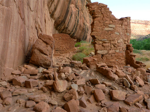
The Main Ruin
The pueblo consists of one large structure and several smaller rooms, together extending over 300 feet, while on the cliff are a small number of pictographs, including some black bison, and many petroglyphs, mostly spirals and other geometric figures. Many of the designs are rather faint, though for some this is due to surface coatings, presumably deposited by rainwater washing down the cliffs, rather than weathering. Post holes and rock art some distance above ground indicates existence of high-level rooms, on two or even three stories. Several smaller structures, and more petroglyphs, can be found beyond the fenced-off area, around a corner, where the cliff bends to the north.
More Ruins
The continuation track is much less used by vehicles. It passes back to the south side of the stream, later followed by two more crossings in quick succession, after which the vegetation lessens somewhat and the canyon becomes more open, the stream more likely to be dry. The next ruin, 1.3 miles from the start, is also on the north side, overlooking the tree-lined junction of a minor tributary; this structure has two components, one incorporating a neat doorway, and is built on a shady ledge around 30 feet above the streambed. There are no more ruins for about a mile, by which time, after several bends, the canyon opens out and is fairly straight, then just after a projecting ridge topped with several pinnacles is a high level group of ruins on the north side along an extensive bench at the foot of a big cliff, seemingly impossible to reach from creek level. This location is just before the junction of a much bigger north-side tributary and it seems a suitable turnaround place, for a half day hike. The canyon does have other ancient sites, over the next few miles, but all seem to be high up and out of reach.
Lower Arch Canyon - Similar Hikes
All Contents © Copyright The American Southwest | Comments and Questions | Contribute | Affiliate Marketing Disclosure | Site Map