
Highlights:
Hundreds of Anasazi ruins, pictographs and petroglyphs in the mesa and canyon country of southeast Utah, north of the San Juan River; reachable by dayhikes or backpacking trips
Management:
BLM
Location:
37.524, -109.895 (Kane Gulch ranger station)
Rating (1-5):
★★★★★
Seasons:
Spring and fall are best; summers are hot, while winters can be cold and snowy

Ceda Mesa is part of the Indian Lands itinerary
The most numerous and varied collections of ancient ruins in Utah are found in the southeast corner of the state, spread throughout a large, rather remote area of 30 by 25 miles (see map), consisting of a wooded plateau over 6,500 feet elevation, split by dozens of branched canyons through Cedar Mesa sandstone and including, to the east, part of the 110 mile long monocline of Comb Ridge. All is public land, managed by the BLM, and for many years it had no special protection other than around the largest drainage (Grand Gulch), which is designated a wilderness study area, formerly a primitive area. Since December 2016, Comb Ridge and adjacent lands to the north are part of the Shash Jaa unit of Bears Ears National Monument.
Known generally as Grand Gulch or Cedar Mesa (the central plateau), this comparatively little known district is bordered by the San Juan River to the south, the foothills of the Abajo Mountains to the north and Red House Cliffs to the west. To the east, beyond Comb Ridge, the region merges with other, more scattered areas of ruins including Montezuma Canyon and Hovenweep National Monument.
Known generally as Grand Gulch or Cedar Mesa (the central plateau), this comparatively little known district is bordered by the San Juan River to the south, the foothills of the Abajo Mountains to the north and Red House Cliffs to the west. To the east, beyond Comb Ridge, the region merges with other, more scattered areas of ruins including Montezuma Canyon and Hovenweep National Monument.
Cedar Mesa Table of Contents
- Map of Cedar Mesa
- Photographs
- The canyons
- Ruins on Cedar Mesa
- Grand Gulch locations
- Featured Cedar Mesa canyons
- Nearby places
- Similar places
Location
Map of Cedar Mesa, showing all canyons and the locations of major ruins in Grand Gulch, Cedar Mesa and Comb Ridge.

Photographs
All Cedar Mesa photographs.
The Canyons
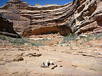
Main roads through the area are US 163 across the south and UT 276/UT 95 in the north, linked by UT 276 which traverses the highest part of Cedar Mesa and crosses the upper end of Kane Gulch, a Grand Gulch tributary, next to which is a BLM ranger station that provides a focal point for visitors - nearby are a campground and several major trailheads. The mesa is quite lightly regulated, and free, vehicle-based camping is allowed anywhere along the side tracks branching off the paved routes, though reservations and permits are needed for any overnight stays down in the canyons, since although numerous ruins are within reach of a long or short day hike, many more remote places need at least one night camping. The canyons are somewhat popular just as a quiet, unspoilt backpacking destination, for people not especially interested in ancient ruins, yet are not particularly scenic - there are no very narrow sections as are found in the White Canyon system to the north, instead the ravines are rather wide, often quite overgrown and boulder-filled, enclosed by dull-colored rocks, either reddish or grey/white. The deepest and most spectacular section is the middle part of Grand Gulch, where the sheer sandstone cliffs reach up to 800 feet high.
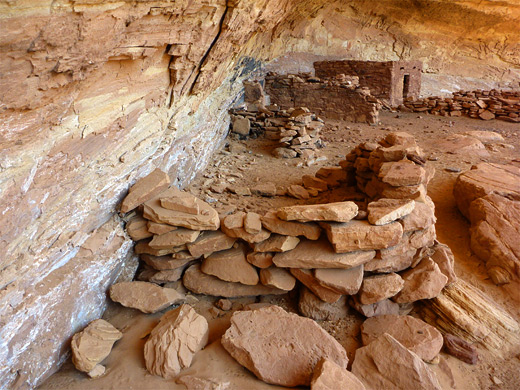
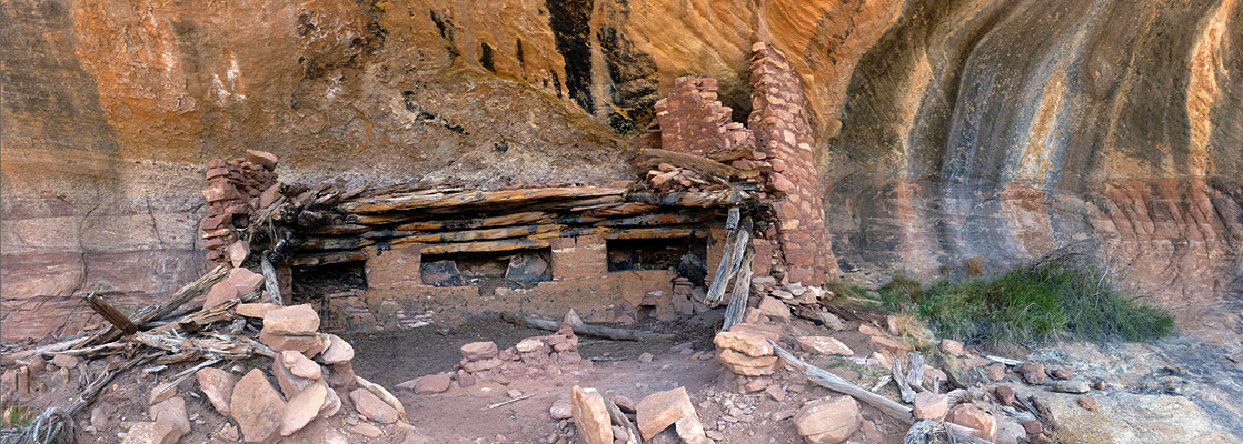
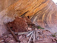
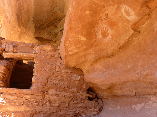
Cedar Mesa Ruins
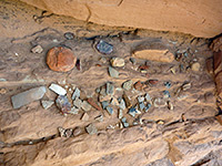
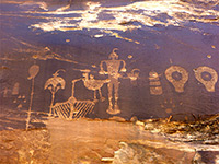
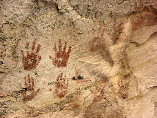
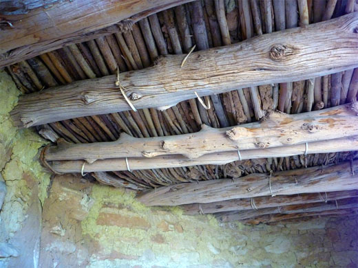
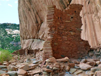
Besides hundreds of ruins, mostly cliff dwellings, the Cedar Mesa region also has many petroglyphs and pictographs, all between 2,000 and 800 years old, from the Anasazi or Ancestral Pueblo culture; these peoples typically farmed and hunted on the mesa tops, while inhabiting the more sheltered confines of the canyons, where water was more easily acquired and conditions were cooler in the long summer months. Although all ruins will have been studied and recorded in recent times, the vast majority are unreconstructed and unprotected, and many still have visible artefacts on the surface, hence must be visited with care and responsibility. Fortunately most sites are far from main roads so need some determination to reach, and won't be seen by the casual visitor.
Grand Gulch Locations
The greatest concentration of ruins is in Grand Gulch itself, or at least the upper four fifths of it (40 miles), plus several tributaries, principally Step Canyon, Sheiks Canyon and Bullet Canyon. Further south, the upper forks of Slickrock Canyon and Johns Canyon have many sites, all within reach of a day hike. North of UT 95, two of the most concentrated groups of ruins are in the north and south forks of Mule Canyon, both easily accessed from the highway, while nearby Arch Canyon also has one large ruin, just 0.4 miles from the trailhead. South of UT 95 and east of UT 261 the canyons are a little harder to get to, requiring longer drives on unpaved roads, but contain equally extensive, well preserved ruins - major drainages are Fish Creek, Owl Creek, McCloud Canyon, Road Canyon (north and south) and Lime Canyon. The easternmost ruins in the Cedar Mesa area are found on the less steep east side of Comb Ridge, close to Butler Wash which like the good quality access track runs parallel to the monocline for over 20 miles. At least a dozen of the small canyons cutting into the ridge have ruins and petroglyphs towards the upper ends, each within reach of a hike of an hour or so. Besides all these backcountry locations are several developed, roadside sites such as the Sand Island pictograph panel a few miles west of Bluff, Mule Canyon mesa top ruins and Butler Wash ruins, these latter both along UT 95, either side of Comb Ridge.
Featured Cedar Mesa Canyons
Arch Canyon
★★★★★
★★★★★
2.5 miles, 170 feet
Deep canyon containing a ruin with plentiful rock art near the lower end, and other ancient sites upstream, plus several arches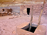
Bullet Canyon
★★★★★
★★★★★
6.7 miles, 900 feet
Large Grand Gulch tributary sheltering two significant Anasazi sites, Perfect Kiva Ruins and Jailhouse Ruins, together with several granaries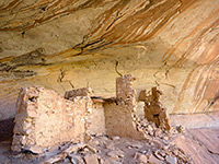
Comb Ridge and Butler Wash
★★★★★
★★★★★
0.2 to 2 miles; various hikes
Numerous petroglyphs, pictographs and Anasazi ruins, in short canyons on the east side of Comb Ridge, an exposed monocline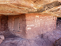
Johns Canyon, West Fork
★★★★★
★★★★★
3 miles, 400 feet (loop), or longer
Two main ruins plus several lesser sites, in the upper end of a relatively little-visited canyon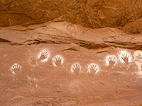
Lower Fish Creek
★★★★★
★★★★★
5 miles, 250 feet
East-side Cedar Mesa canyon with a permanent stream draining into Comb Wash, containing about ten ancient sites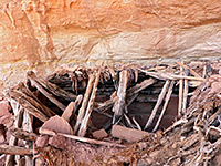
Lime Canyon
★★★★★
★★★★★
6 miles, 650 feet (round trip)
Several ruins along the upper end of a major canyon, one containing a complete kiva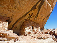
Lower Mule Canyon
★★★★★
★★★★★
1 mile, 100 feet
Downstream end of a long drainage on the east side of Cedar Mesa, containing several groups of ruins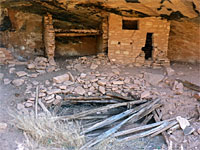
Mule Canyon, North Fork
★★★★★
★★★★★
2.8 miles, 200 feet
Four groups of ancient structures in a relatively shallow canyon, not so often explored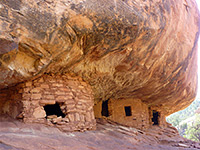
Mule Canyon, South Fork
★★★★★
★★★★★
4.3 miles, 250 feet
Fairly shallow, level and easily explored canyon close to UT 95, containing at least eight groups of ruins (including House on Fire), some quite large and intricate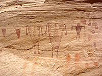
Sheiks Canyon
★★★★★
★★★★★
3 miles, 800 feet
Short tributary of Grand Gulch containing several Anasazi dwellings including Yellow House Ruins and Green Mask Ruins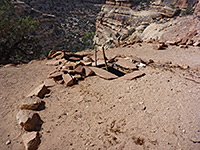
Slickhorn Canyon
★★★★★
★★★★★
2.5 miles, 800 feet
San Juan River tributary with four relatively short upper forks, all containing Anasazi ruins and pictographs, explorable on day hikes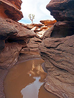
Steer Gulch
★★★★★
★★★★★
8 miles, 400 feet (loop)
Treeless, mostly shallow canyon with occasional pools and narrow channels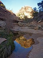
Todie Canyon
★★★★★
★★★★★
2 miles, 600 feet
Relatively short but steeply sloping ravine used as a route to Grand Gulch; contains a shallow stream and a few inaccessible ruinsCedar Mesa - Nearby Places
- Goosenecks State Park - deep meanders of the San Juan River
- Natural Bridges National Monument - three large natural bridges
Cedar Mesa - Similar Places
- Horseshoe Canyon, Canyonlands National Park, Utah - pictographs in a remote canyon
- Nine Mile Canyon, Utah - thousands of ancient petroglyphs
- Mesa Verde National Park, Colorado - the Southwest's largest collection of ancient ruins
All Contents © Copyright The American Southwest | Comments and Questions | Contribute | Affiliate Marketing Disclosure | Site Map