Todie Canyon
Relatively short but steeply sloping ravine used as a route to Grand Gulch; contains a shallow stream towards the lower end and a few inaccessible ruins, high up on benches
Length: 2 miles, to the Grand Gulch confluence
Elevation change: 600 feet
Difficulty: Moderate to strenuous; steep, rocky and overgrown
Type: One way, along an official trail
Usage: Low
Season: Spring, summer, fall
Trailhead: Parking area at the end of a short track west of UT 261
Rating (1-5): ★★★★★
Elevation change: 600 feet
Difficulty: Moderate to strenuous; steep, rocky and overgrown
Type: One way, along an official trail
Usage: Low
Season: Spring, summer, fall
Trailhead: Parking area at the end of a short track west of UT 261
Rating (1-5): ★★★★★

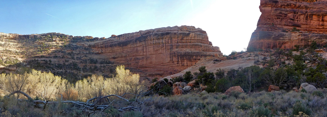
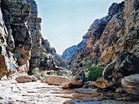
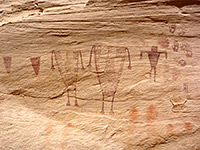
Todie Canyon is an east-side tributary of Grand Gulch in the middle of Cedar Mesa, and like most canyons hereabouts it contains Anasazi ruins, though the sites are rather inaccessible and distant, located in high alcoves near the lower end of the drainage, where the cliffs are 500 feet tall. The canyon is enclosed for about 2 miles, and receives most use as an entry/exit route to and from the gulch; the distance to the confluence from more usual approach, starting at Kane Gulch Ranger station on Hwy 261, is over three times as long.
Once in Grand Gulch, many more ruins can be viewed, mostly downstream, and people commonly spend several days exploring them. But a trip just down Todie Canyon to the gulch and back is an interesting half day hike, albeit rather strenuous as the canyon slopes down steeply and is quite overgrown in some parts. The route down, although rough, is via an official trail.
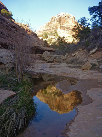
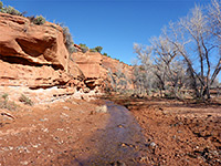
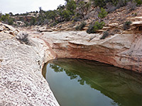
The ravine is moderately scenic, especially the lower end, where a shallow creek flows through pools and over little cascades, and the gorge is bordered by dramatic cliffs of rich, red/orange Cedar Mesa sandstone. The grassy banks beside the stream provide good places for primitive camping. The trailhead is also a good location for overnight stays, being just one mile from the highway, quiet and peaceful. A $2 fee is charged to park here.
Guidelines for visiting archaeological sites
The 1.2 mile road to the upper end of Todie Canyon leaves Hwy 261 (west side) 3.5 miles south of Kane Gulch and 29 miles north of Mexican Hat. This smooth dirt track crosses an open, grassy plain (Todie Flat), passes an old corral, and ends at a small, rocky parking area. Another track forks off nearby, towards designated camping places.
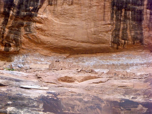
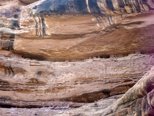
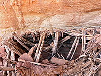
The trail leads northwestwards, through bushes and trees and over slickrock bordering the southern canyon rim to the head of a short, steep gully, which provides a quick route to the canyon floor, already 200 feet below the plateau. The next mile or so is directly along the streambed, descending steadily through jumbles of big boulders and groups of trees, and down a few pour-overs. The path is marked by cairns in places and is easy enough to locate but rather tiring to follow, especially when returning. A large tributary joins from the north, as the cliffs on both sides become very high and sheer. Just before the second and last major tributary, also on the north side, is a line of about 25 Anasazi granaries, well preserved but high up and difficult to reach, as are the next set of ruins - several rooms on another high ledge, shortly before the junction with Grand Gulch. One room retains some of the original roof timbers. At the confluence, the gulch is fairly wide, bushy and steep-walled, and contains its own permanent stream, mostly flowing along little channels eroded through the sediment that covers the canyon floor. The round-trip to this place takes from two and half hours.
Once in Grand Gulch, many more ruins can be viewed, mostly downstream, and people commonly spend several days exploring them. But a trip just down Todie Canyon to the gulch and back is an interesting half day hike, albeit rather strenuous as the canyon slopes down steeply and is quite overgrown in some parts. The route down, although rough, is via an official trail.
The ravine is moderately scenic, especially the lower end, where a shallow creek flows through pools and over little cascades, and the gorge is bordered by dramatic cliffs of rich, red/orange Cedar Mesa sandstone. The grassy banks beside the stream provide good places for primitive camping. The trailhead is also a good location for overnight stays, being just one mile from the highway, quiet and peaceful. A $2 fee is charged to park here.
Guidelines for visiting archaeological sites
Todie Canyon Trailhead
The 1.2 mile road to the upper end of Todie Canyon leaves Hwy 261 (west side) 3.5 miles south of Kane Gulch and 29 miles north of Mexican Hat. This smooth dirt track crosses an open, grassy plain (Todie Flat), passes an old corral, and ends at a small, rocky parking area. Another track forks off nearby, towards designated camping places.
The Canyon
The trail leads northwestwards, through bushes and trees and over slickrock bordering the southern canyon rim to the head of a short, steep gully, which provides a quick route to the canyon floor, already 200 feet below the plateau. The next mile or so is directly along the streambed, descending steadily through jumbles of big boulders and groups of trees, and down a few pour-overs. The path is marked by cairns in places and is easy enough to locate but rather tiring to follow, especially when returning. A large tributary joins from the north, as the cliffs on both sides become very high and sheer. Just before the second and last major tributary, also on the north side, is a line of about 25 Anasazi granaries, well preserved but high up and difficult to reach, as are the next set of ruins - several rooms on another high ledge, shortly before the junction with Grand Gulch. One room retains some of the original roof timbers. At the confluence, the gulch is fairly wide, bushy and steep-walled, and contains its own permanent stream, mostly flowing along little channels eroded through the sediment that covers the canyon floor. The round-trip to this place takes from two and half hours.
Todie Canyon - Similar Hikes
All Contents © Copyright The American Southwest | Comments and Questions | Contribute | Affiliate Marketing Disclosure | Site Map