Lime Canyon
Major ravine on the east side of Cedar Mesa containing several Ancestral Puebloan ruins. Most are rather inaccessible, but one site in a tributary ravine is more easily reached and has several ancient structures, including a complete kiva
Length: 6 miles, round trip, starting at the 4WD parking area, or 8.7 miles round trip from Hwy 261
Elevation change: 650 feet
Difficulty: Moderate; a few obstacles in the main canyon, and a traverse of steep slopes in the tributary
Type: Off trail loop
Usage: Low
Season: Spring and fall - winters are cold and potentially snowy, while summers are very hot
Trailhead: 1.7 miles along a dirt track (4WD), or at the junction along Hwy 261 (2WD)
Rating (1-5): ★★★★★

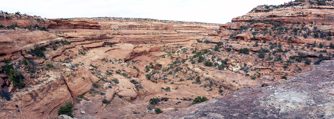
Lime Canyon is a major drainage of two forks, cutting across the southeast corner of Cedar Mesa, eventually meeting the San Juan River after winding through the red formations of the Valley of the Gods. Both branches of the canyon contain Ancestral Puebloan ruins, but the most visited and easiest reached are those in the east, or main fork, the upper end of which is accessed by driving 1.7 miles along a rough track, starting from Hwy 261, 6.5 miles north of the Moki Dugway.
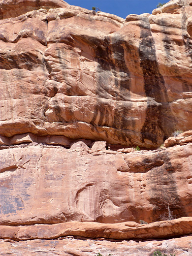
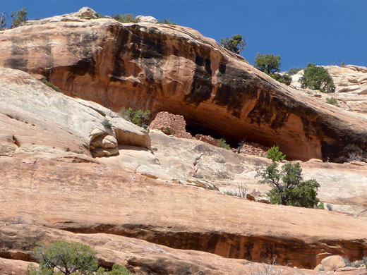
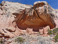
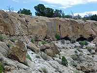
This ravine deepens steadily, though lacks any major dryfalls or other obstructions, and has at least ten groups of ancient structures along the first four miles, however unlike some other Cedar Mesa canyons most are inaccessible, since they are located high up, usually at the base of the uppermost section of cliffs, protected from access below by several other sheer bands of rock. Gaining entry from rim level would potentially be easier, but only if an exact approach route has been identified, as the ruins are not visible from above.
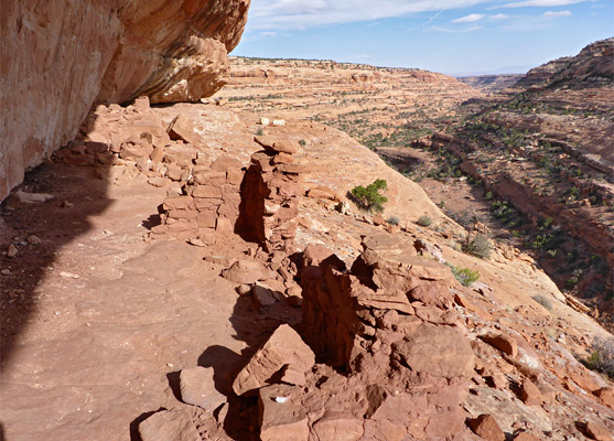
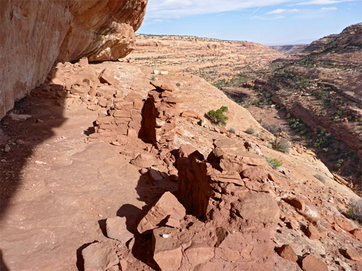
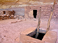
The one main exception is a site on the south side, up a tributary ravine; known as Little Citadel, this is positioned for commanding views downstream, and consists of several structures, including a fine kiva, complete with (collapsed) roof, intact pillars and benches. This, the best site in the whole canyon, may be seen along a 6 mile loop hike - following the drainage downstream, up the tributary to the ruin then further climbing to the rim, returning via a rather monotonous walk along a sandy track. The access road is sandy, bumpy and/or rocky in places so may require a 4WD vehicle; walking from the start point, along Hwy 261, adds another 2.7 miles to the round trip hike.
Guidelines for visiting archaeological sites
Map of Cedar Mesa, Grand Gulch and Comb Ridge.
20 views of Lime Canyon.
The track to Lime Canyon is marked only with a generic sign, though a trailhead register is reached after a few hundred feet. A small amount of parking is available at the junction, for non-high clearance vehicles. The track is straight, narrow and uneven, crossing a few rock patches but mostly sandy earth. It bends slightly after about a mile, passes over a low brow, soon followed by a sign marking the edge of the Road Canyon Wilderness Study Area, then arrives at a junction, just before a rocky knoll, which has a small ruin on top. Turning left (northwest), the track descends a rocky slope and becomes rougher as the canyon comes into view. Parking is on slickrock patches near the rim. A small ruin is visible from the rim, high up on the far side, the canyon at this point being about 150 feet deep.
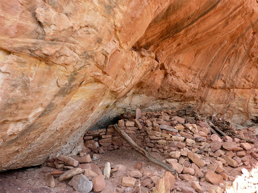
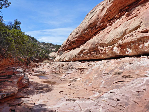
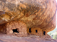
The streambed is reached by a quick climb down benches and slopes, and it deepens relatively slowly, via little drops between long, flatter stretches. One dryfall is slightly bigger, a U-shaped drop, followed by a little tributary on the left. The pinkish red canyon sides are formed of many cliffs, benches and ledges, all quite thin - there is no single, thick rock layer, and so plenty of potential climb out routes. Another tributary joins from the south, and opposite here a ruin is visible to the north, also high above the creekbed, seemingly difficult to enter even from above because of a continuous, slightly overhanging cliff. Shortly after is a pair of prominent hoodoos, on the north side, another minor tributary to the south, and a bend to the left, after which another ruin is glimpsed, to the north; a room, with two wall fragments one bench lower, and two tiny, adjacent granaries.
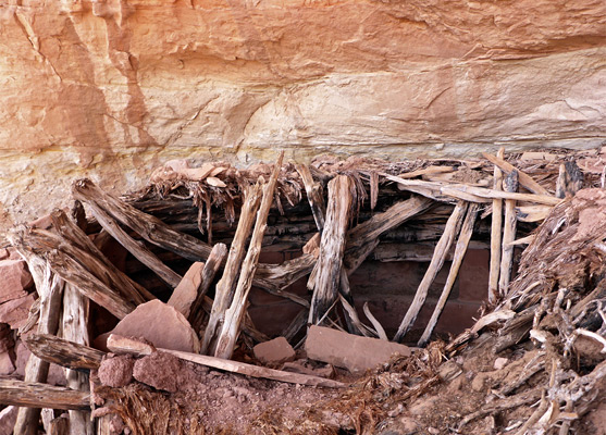
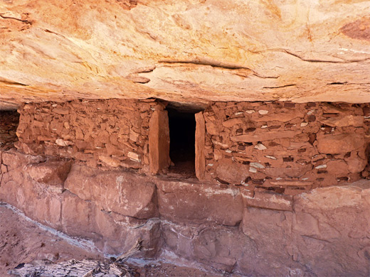
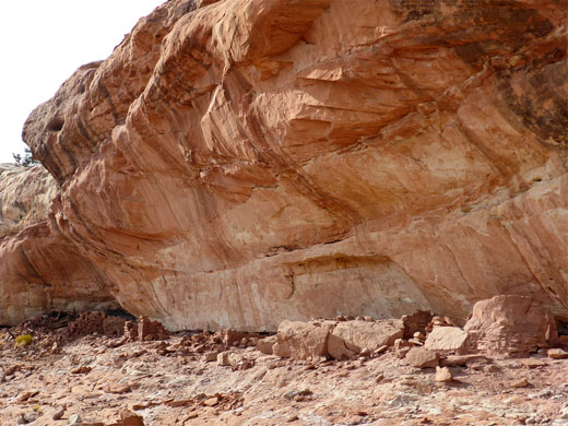
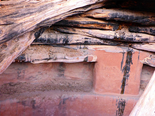
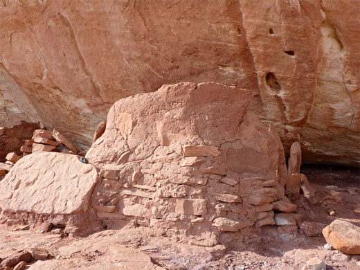
All these ruins are inaccessible but there is, after a couple of minor bends, one structure close to the streambed, though out of sight from it, up in an alcove along the first bench - a neat granary with fragments of a rectangular wall below and a ruined enclosure to the right. This is about 600 feet before the confluence with the larger, southwest-trending tributary containing the Little Citadel. The ruins here are about 250 feet up on the northwest side, about half way along the drainage. The easiest way to reach them seems to be to stay in or near the streambed until nearly underneath, then climb the benches and slopes. This site consists of adobe wall fragments, two partial rectangular rooms, some lesser foundations, an intact room adjoining a granary (still full of grains) and the kiva, the wooden beams of which have carvings from early travellers and are blackened with soot and tar.
The return route, partially cairned, leads further southwest along the edge of the canyon, staying at the same level as the ruin, curving beneath a dryfall in the little west fork, crossing a divide and entering the little south fork, where the gradient lessens, allowing scrambling up to the rim. A short walk southwards through featureless pinyon/juniper woodland intersects a sandy track, which is followed for 2.7 miles westwards, back to the junction near the 4WD trailhead. The track initially offers no views, but later climbs slightly, passing several pinkish/white sandstone outcrops, becoming high enough to see a long way across the mesa, in all directions.
This ravine deepens steadily, though lacks any major dryfalls or other obstructions, and has at least ten groups of ancient structures along the first four miles, however unlike some other Cedar Mesa canyons most are inaccessible, since they are located high up, usually at the base of the uppermost section of cliffs, protected from access below by several other sheer bands of rock. Gaining entry from rim level would potentially be easier, but only if an exact approach route has been identified, as the ruins are not visible from above.
The one main exception is a site on the south side, up a tributary ravine; known as Little Citadel, this is positioned for commanding views downstream, and consists of several structures, including a fine kiva, complete with (collapsed) roof, intact pillars and benches. This, the best site in the whole canyon, may be seen along a 6 mile loop hike - following the drainage downstream, up the tributary to the ruin then further climbing to the rim, returning via a rather monotonous walk along a sandy track. The access road is sandy, bumpy and/or rocky in places so may require a 4WD vehicle; walking from the start point, along Hwy 261, adds another 2.7 miles to the round trip hike.
Guidelines for visiting archaeological sites
Location
Map of Cedar Mesa, Grand Gulch and Comb Ridge.
Photographs
20 views of Lime Canyon.
Track to Lime Canyon
The track to Lime Canyon is marked only with a generic sign, though a trailhead register is reached after a few hundred feet. A small amount of parking is available at the junction, for non-high clearance vehicles. The track is straight, narrow and uneven, crossing a few rock patches but mostly sandy earth. It bends slightly after about a mile, passes over a low brow, soon followed by a sign marking the edge of the Road Canyon Wilderness Study Area, then arrives at a junction, just before a rocky knoll, which has a small ruin on top. Turning left (northwest), the track descends a rocky slope and becomes rougher as the canyon comes into view. Parking is on slickrock patches near the rim. A small ruin is visible from the rim, high up on the far side, the canyon at this point being about 150 feet deep.
Inaccessible Ruins
The streambed is reached by a quick climb down benches and slopes, and it deepens relatively slowly, via little drops between long, flatter stretches. One dryfall is slightly bigger, a U-shaped drop, followed by a little tributary on the left. The pinkish red canyon sides are formed of many cliffs, benches and ledges, all quite thin - there is no single, thick rock layer, and so plenty of potential climb out routes. Another tributary joins from the south, and opposite here a ruin is visible to the north, also high above the creekbed, seemingly difficult to enter even from above because of a continuous, slightly overhanging cliff. Shortly after is a pair of prominent hoodoos, on the north side, another minor tributary to the south, and a bend to the left, after which another ruin is glimpsed, to the north; a room, with two wall fragments one bench lower, and two tiny, adjacent granaries.
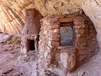
Granary and the Little Citadel
All these ruins are inaccessible but there is, after a couple of minor bends, one structure close to the streambed, though out of sight from it, up in an alcove along the first bench - a neat granary with fragments of a rectangular wall below and a ruined enclosure to the right. This is about 600 feet before the confluence with the larger, southwest-trending tributary containing the Little Citadel. The ruins here are about 250 feet up on the northwest side, about half way along the drainage. The easiest way to reach them seems to be to stay in or near the streambed until nearly underneath, then climb the benches and slopes. This site consists of adobe wall fragments, two partial rectangular rooms, some lesser foundations, an intact room adjoining a granary (still full of grains) and the kiva, the wooden beams of which have carvings from early travellers and are blackened with soot and tar.
Return Route
The return route, partially cairned, leads further southwest along the edge of the canyon, staying at the same level as the ruin, curving beneath a dryfall in the little west fork, crossing a divide and entering the little south fork, where the gradient lessens, allowing scrambling up to the rim. A short walk southwards through featureless pinyon/juniper woodland intersects a sandy track, which is followed for 2.7 miles westwards, back to the junction near the 4WD trailhead. The track initially offers no views, but later climbs slightly, passing several pinkish/white sandstone outcrops, becoming high enough to see a long way across the mesa, in all directions.
Lime Canyon - Similar Hikes
All Contents © Copyright The American Southwest | Comments and Questions | Contribute | Affiliate Marketing Disclosure | Site Map