Tsankawi Trail, Bandelier National Monument
New Mexico > Bandelier National Monument > Hiking > Tsankawi Trail
Tsankawi Trail
Loop around a mesa in a detached section of the national monument, visiting ruins, cave dwellings, petroglyphs and ancient pathways
Length: 1.5 miles (loop)
Elevation change: 200 feet
Difficulty: Easy to moderate; a few steep sections, with ladders in some places
Type: Partial loop
Usage: Medium
Season: All year, though icy in winter
Trailhead: Pull-out along Hwy 4
Rating (1-5): ★★★★★
Elevation change: 200 feet
Difficulty: Easy to moderate; a few steep sections, with ladders in some places
Type: Partial loop
Usage: Medium
Season: All year, though icy in winter
Trailhead: Pull-out along Hwy 4
Rating (1-5): ★★★★★

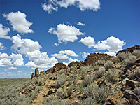
Tsankawi is a detached section of Bandelier National Monument, 11 miles by road north of the main entrance, bordered by the San Ildefonso Indian Reservation to the east and the city of Los Alamos to the west. Although small, the site receives a steady stream of visitors, partly as it lies just off busy highway 502, the main route between Los Alamos and Santa Fe. Tsankawi is centered on a narrow mesa composed of solidified volcanic ash, nearly a mile across but just a few hundred feet wide, in the middle of which are the unexcavated remains of an ancient pueblo, at its peak consisting of around 300 rooms, on several storeys, built around a circular plaza.
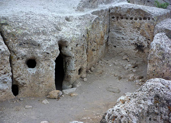
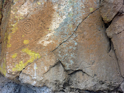
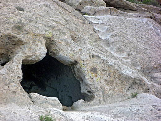
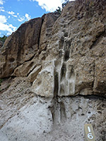
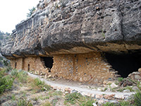
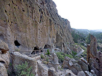
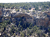
The whole site is overgrown and barely recognizable as a former village, however much more interesting are a series of pictographs and cave dwellings on the south side of the mesa - like at Frijoles Canyon, the ancient tribes enlarged and augmented natural cavities in the volcanic rocks to form larger dwellings, known as cavates. These are linked by original pathways and staircases, easily carved from the soft bedrock, and part of the 1.5 mile trail across the mesa follows the same ancient trails, some worn down to depths of two feet or more. A few steep places make the hike just a little strenuous, but the site can be toured in just an hour or so. The pathways are unique, the best feature of the site; the cavates are generally smaller and less complete than in Frijoles Canyon, and the petroglyphs, although numerous, are mostly quite faded.
Tsankawi was occupied during the fifteenth and sixteenth centuries, by the Ancestral Pueblo peoples, one possible reason for its abandonment being a sustained drought. Today, their descendants inhabit the adjacent Indian reservation.
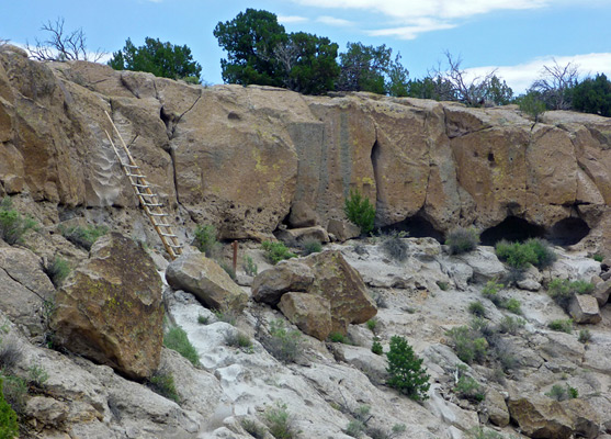
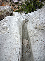
Parking for the trail is at a long pullout beside busy, noisy highway 4, just south of the Hwy 502 intersection and opposite the junction with Jemez Road, the alternative, southern approach to Los Alamos. From this rather unpromising beginning, the well used path climbs gently up a dry, sandy, bushy hillside sparsely covered with pinyon and juniper pines, up to the base of the mesa, ascending one intermediate rock layer via a 12 foot wooden ladder (first of three on the route), then following below a band of small cliffs formed of holey, orange-grey tuff, the start of a one mile loop section. The final part of the climb to the mesa is along a grooved path, worn or cut into the ashen rocks, here colored a lighter shade of grey.
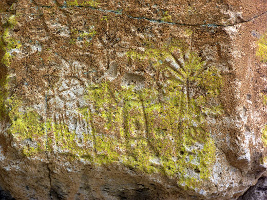
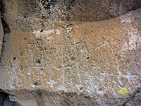
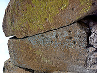
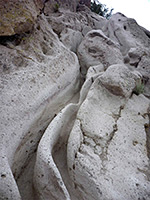
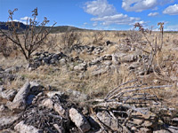
The first of many petroglyphs come into view, all rather faded, partly covered by lichen and hence not very legible, as the light brown surface patina is little different to the greyish color of the underlying rocks. The trail proceeds eastwards along the narrow mesa top, which widens towards the middle, at the location of the unexcavated pueblo, but this has little of interest to see apart from the occasional pot fragment. Steps take the path down a little to a bench just below the rim, where the route turns back west, through the most interesting part of the loop. The next half mile passes many cavates (some of which may be entered), petroglyphs and post holes from long since disappeared dwellings known as talus pueblos, plus other pathways; the trail follows one such route but many more branch off in all directions, including a number of staircases, ascending to the mesa top. The ceilings of some of the caves are blackened with soot from fires five centuries ago. Not all the rock carvings were made by the Ancestral Puebloans; some are from later Spanish explorers. Views to the south encompass a succession of canyons and mesas, some holding other unexcavated ruins.
The whole site is overgrown and barely recognizable as a former village, however much more interesting are a series of pictographs and cave dwellings on the south side of the mesa - like at Frijoles Canyon, the ancient tribes enlarged and augmented natural cavities in the volcanic rocks to form larger dwellings, known as cavates. These are linked by original pathways and staircases, easily carved from the soft bedrock, and part of the 1.5 mile trail across the mesa follows the same ancient trails, some worn down to depths of two feet or more. A few steep places make the hike just a little strenuous, but the site can be toured in just an hour or so. The pathways are unique, the best feature of the site; the cavates are generally smaller and less complete than in Frijoles Canyon, and the petroglyphs, although numerous, are mostly quite faded.
Tsankawi was occupied during the fifteenth and sixteenth centuries, by the Ancestral Pueblo peoples, one possible reason for its abandonment being a sustained drought. Today, their descendants inhabit the adjacent Indian reservation.
Trail to the Mesatop
Parking for the trail is at a long pullout beside busy, noisy highway 4, just south of the Hwy 502 intersection and opposite the junction with Jemez Road, the alternative, southern approach to Los Alamos. From this rather unpromising beginning, the well used path climbs gently up a dry, sandy, bushy hillside sparsely covered with pinyon and juniper pines, up to the base of the mesa, ascending one intermediate rock layer via a 12 foot wooden ladder (first of three on the route), then following below a band of small cliffs formed of holey, orange-grey tuff, the start of a one mile loop section. The final part of the climb to the mesa is along a grooved path, worn or cut into the ashen rocks, here colored a lighter shade of grey.
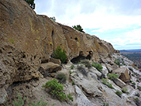
Cavates and Pathways
The first of many petroglyphs come into view, all rather faded, partly covered by lichen and hence not very legible, as the light brown surface patina is little different to the greyish color of the underlying rocks. The trail proceeds eastwards along the narrow mesa top, which widens towards the middle, at the location of the unexcavated pueblo, but this has little of interest to see apart from the occasional pot fragment. Steps take the path down a little to a bench just below the rim, where the route turns back west, through the most interesting part of the loop. The next half mile passes many cavates (some of which may be entered), petroglyphs and post holes from long since disappeared dwellings known as talus pueblos, plus other pathways; the trail follows one such route but many more branch off in all directions, including a number of staircases, ascending to the mesa top. The ceilings of some of the caves are blackened with soot from fires five centuries ago. Not all the rock carvings were made by the Ancestral Puebloans; some are from later Spanish explorers. Views to the south encompass a succession of canyons and mesas, some holding other unexcavated ruins.
Tsankawi Trail - Similar Hikes
All Contents © Copyright The American Southwest | Comments and Questions | Contribute | Affiliate Marketing Disclosure | Site Map