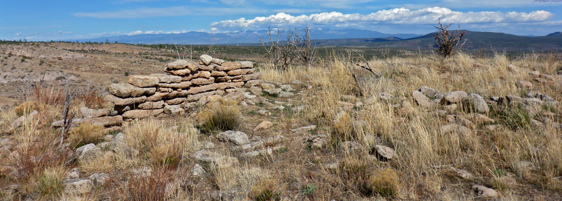

| Alamo Boundary Trail Length 1.3 miles (2.1 km) Elevation change 400 feet (122 meters) Difficulty Easy Type One way Usage Low Season Spring, summer, fall Trailhead 1.7 miles along St Peters Dome Road (FR 289). Also reached from Hwy 4 Rating (1-5) ★★★★★ In the northeast corner of the national monument, the Alamo Boundary Trail climbs a lightly wooded valley to a saddle between two volcanic peaks then has a shorter but slightly steeper descent on the far side, down to an alternative trailhead along Hwy 4 (for the Coyote Call Trail, within Valles Caldera National Preserve). |
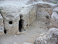
| Alcove House Length 1.1 miles (1.8 km) Elevation change 400 feet (122 meters) Difficulty Easy, but a steep climb at the end, up ladders Type One way Usage Medium Season All year Trailhead Parking area by the visitor center Rating (1-5) ★★★★★ Formerly known as Ceremonial Cave, Alcove House is another cliff dwelling in Frijoles Canyon, reached by a continuation trail that branches off the main loop, follows the streambed to the base of the ruins then climbs 140 feet via four long ladders. The site includes a reconstructed kiva. |
| Burnt Mesa Trail Length 2.5 miles (4 km) Elevation change 370 feet (113 meters) Difficulty Easy Type One way Usage Low Season Spring, summer, fall Trailhead Pull-out on the south side of Hwy 4 Rating (1-5) ★★★★★ There are no ruins along the Burnt Mesa Trail; instead, the attractions are the abundant summer wildflowers and, towards the end, the views of Frijoles Canyon. Most of the surroundings are open and grassy, with just occasional trees and bushes. The route follows an old vehicle track, so is wide and easy to follow. |
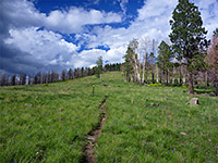
| Cerro Grande Trail Length 2 miles (3.2 km) Elevation change 1250 feet (381 meters) Difficulty Moderate Type One way Usage Low Season Late spring, summer, fall Trailhead Parking area along Hwy 4 Rating (1-5) ★★★★★ The volcanic summit of Cerro Grande (10,200 feet) lies just beyond the northern tip of Bandelier National Monument, and may be reached by a hike over smooth slopes, covered by grass or open woodland. The marked trail is steep but not too difficult, during calm weather. The hillsides bear many wildflowers in mid to late summer. The views from the peak extend across the adjacent Valles Caldera National Preserve. |
| Falls Trail Length 1.5 miles (2.4 km) Elevation change 400 feet (122 meters) Difficulty Easy Type One way Usage Medium Season All year Trailhead Backpacker/overflow parking area Rating (1-5) ★★★★★ Path downstream along Frijoles Canyon, from wooded surroundings around the visitor center into more desert-like terrain, ending at the brink of the Upper Falls. The trail once continued another mile to the Rio Grande, but flood damage has rendered this section inaccessible. |
| Frey Trail Length 1.5 miles (2.4 km) Elevation change 600 feet (183 meters) Difficulty Moderate Type One way Usage Low Season All year; hot and exposed in summer Trailhead Juniper Campground Rating (1-5) ★★★★★ The Frey Trail links Juniper Campground with the visitor center, following the original entrance route into Frijoles Canyon, prior to construction of the current road in the 1930s. Most is close to the rim of the canyon; the descent is towards the end, as the path curves down a side ravine, giving good views of Tyuonyi Ruin below. |
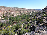
| Frijolito Loop Trail Length 2.5 miles (4 km), loop Elevation change 520 feet (158 meters) Difficulty Moderate Type Loop Usage Low Season All year, unless snow-covered in winter Trailhead Parking area by the visitor center Rating (1-5) ★★★★★ An unexcavated mesa top ruin (Frijolito) is visited by this lightly used loop trail which starts by switchbacking steeply up the south side of Frijoles Canyon to the wooded plateau above, and reaches the archeological site soon after. It continues northwest a little way further, close to the canyon rim, then returns via a section of the Long Trail. |
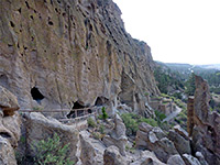
| Main Loop Trail Length 1.2 miles (1.9 km) Elevation change 200 feet (61 meters) Difficulty Easy Type Loop trail Usage High Season All year Trailhead Parking area by the visitor center Rating (1-5) ★★★★★ This is the most popular path in Bandelier National Monument; a loop trail, partly paved, passing many ruins along the north side of Frijoles Canyon, the three main sites being Tyuonyi Pueblo, Talus House and Long House. The return is through woodland on the south side of the canyon - pretty surroundings with plentiful flowers, and the chance of glimpsing lizards, snakes and other wildlife. |
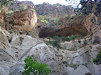
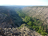
| Painted Cave Length 11 miles (17.7 km) Difficulty Strenuous Type One-way, or partial loop Usage Very low Season Spring, summer, fall Trailhead By the visitor center. Also accessed from the Dome Trailhead, for which 4WD is usually necessary; hike distance is then 7 miles Rating (1-5) ★★★★★ The most remote hiking destination in Bandelier is the Painted Cave, a large alcove adorned with dozens of well preserved pictographs, situated on the east side of Capulin Canyon, 2.3 miles from the Rio Grande confluence. From the visitor center, the route crosses a long succession of canyons and ridges, with a cumulative elevation change of over 6,000 feet. This cave is usually visited on overnight trips. |
| Tsankawi Trail Length 1.5 miles (2.4 km), round trip Elevation change 200 feet (61 meters) Difficulty Easy to moderate; a few steep sections, with ladders in some places Type Loop Usage Medium Season All year, though icy in winter Trailhead Pull-out along Hwy 4 Rating (1-5) ★★★★★ The detached Tsankawi section of Bandelier National Monument (12 miles northeast along Hwy 4), can be explored by a short loop trail that climbs to the top of a grassy mesa, passing through an overgrown pueblo site, then returns along ledges a little way below the rim, within sight of many alcove ruins, petroglyphs and other ancient structures. Parts of the route follow ancient pathways, chiseled out of the soft volcanic bedrock. |
| Tyuonyi Overlook Trail Length 1.1 miles (1.8 km) Elevation change 140 feet (43 meters) Difficulty Easy Type One way Usage Medium Season All year Trailhead Juniper Campground Rating (1-5) ★★★★★ From the national monument campground, this easy trail heads southeast across the pinyon-juniper plateau on the north side of Frijoles Canyon, out to the tip of a narrow promontory above Tyuonyi Ruin. There are several small unexcavated sites along the way. Views are extensive, all along the lower section of the canyon, both east and west. |
| Yapashi Pueblo Trail Length 6 miles (9.7 km) Elevation change 800 feet (243 meters) Difficulty Strenuous Type One way Usage Very low Season Spring and fall are best Trailhead Parking area by the visitor center Rating (1-5) ★★★★★ Yapashi is one of Bandelier's backcountry ruins; a remote location on a spur of land between Hondo and Alamo canyons. Including Frijoles Canyon at the start, the rarely-traveled path to the ruins climbs up and down six ravines, Alamo being the deepest. |

All Contents © Copyright The American Southwest | Comments and Questions | Contribute | Affiliate Marketing Disclosure | Site Map