New Mexico Hiking Trails
Other NPS units with one or more extended trails are Bandelier, El Malpais and White Sands.
Map shows trailhead locations
1. Alcove House, Bandelier National Monument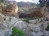 Length 1.1 miles (1.8 km) Elevation change 400 feet (122 meters) Difficulty Easy, but a steep climb at the end, up ladders Rating (1-5) ★★★★★ Formerly known as Ceremonial Cave, Alcove House is another cliff dwelling in Frijoles Canyon, reached by a continuation trail that branches off the main loop, follows the streambed to the base of the ruins then climbs 140 feet via four long ladders. The site includes a reconstructed kiva. |
2. Alkali Flat Trail, White Sands National Park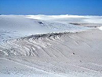 Length 4.6 miles (7.4 km) Elevation change 0 feet (0 meters) Difficulty Easy to moderate Rating (1-5) ★★★★★ Loop path across large dunes, completely lacking any vegetation, to a dry lake bed (Alkali Flat) at the edge of the sands. The return path, a little way north, encounters similar surroundings. Route is indicated only by footprints and marker posts. |
3. Bernalillito Mesa Trail, Ojito Wilderness Area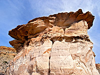 Length 1.4 miles (2.3 km) Elevation change 120 feet (37 meters) Difficulty Easy Rating (1-5) ★★★★★ Ojito is an isolated, little visited wilderness area, and it has one main trail, along the base of Bernalillito Mesa. En route are a number of localized but pretty erosional features, most striking being a beautiful outcrop of teepee-shaped mounds of yellow Dakota sandstone, crossed by thin, delicate pinkish-red layers. One U-shaped passage between two of the cones is reminiscent of the Wave in Arizona |
4. Big Tubes, El Malpais National Monument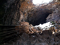 Length 2 miles (3.2 km); (round trip) Elevation change 0 feet (0 meters) Difficulty Easy; moderate in the caves Rating (1-5) ★★★★★ Remote part of the El Malpais lava flow with several caves (containing ice deposits most of the year), a series of lava bridges and a long section of collapsed cave. The caves are currently closed to prevent spread of a fungal disease affecting the resident bats. |
5. Boca Negra Canyon Trails, Petroglyph National Monument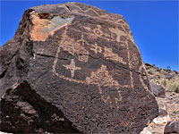 Length 0.8 miles (1.3 km); (round trip) Elevation change 140 feet (43 meters) Difficulty Easy Rating (1-5) ★★★★★ The smallest section of Petroglyph National Monument, comprising a small basin lined to the north by a curving lava slope. Three short, linked trails, visiting around 150 petroglyphs; one path climbs to the top of the mesa, for good views over the city |
6. Canyon Trail, Kasha-Katuwe Tent Rocks National Monument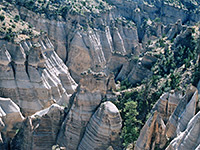 Length 1.5 miles (2.4 km) Elevation change 600 feet (183 meters) Difficulty Moderate - steep, especially towards the upper end Rating (1-5) ★★★★★ One of the best short hiking paths in the state, the Canyon Trail follows a stony wash into a short but beautiful slot canyon, climbs through a large group of the Tent Rocks formations, and ends at a fine, elevated viewpoint. The most spectacular rocks are all around the last part of the trail, where they rise up to 90 feet, pure white, and altogether very impressive. |
7. Ceja Pelon Mesa, Ceja Pelon Mesa Length 2 miles (3.2 km); or more Elevation change 200 feet (61 meters) Difficulty Easy Rating (1-5) ★★★★★ Low, partly wooded mesa, the south edge of which is lined by grey-black badlands, branched ravines, pinnacles, balanced rocks and many pieces of petrified wood; explored by cross-country hiking |
8. Cerro Grande Trail, Bandelier National Monument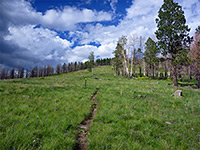 Length 2 miles (3.2 km) Elevation change 1250 feet (381 meters) Difficulty Moderate Rating (1-5) ★★★★★ The volcanic summit of Cerro Grande (10,200 feet) lies just beyond the northern tip of Bandelier National Monument, and may be reached by a hike over smooth slopes, covered by grass or open woodland. The marked trail is steep but not too difficult, during calm weather. The hillsides bear many wildflowers in mid to late summer. The views from the peak extend across the adjacent Valles Caldera National Preserve. |
9. Crater Rim Trail, Capulin Volcano National Monument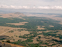 Length 1 mile (1.6 km) Elevation change 300 feet (91 meters) Difficulty Easy, though steep in places Rating (1-5) ★★★★★ The one mile Crater Rim Trail is steep in parts, though short, but often more difficult than might be expected due to frequent strong winds and the high elevation. The rim offers good views of distant lands in all directions, including various lava flows, now mostly grass-covered and difficult to identify from ground level. Another short trail descends into the shallow crater. |
10. Dog Canyon Trail, Oliver Lee Memorial State Park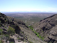 Length 5.5 miles (8.8 km) Elevation change 3140 feet (957 meters) Difficulty Moderate to strenuous Rating (1-5) ★★★★★ The Dog Canyon Trail climbs a cactus-filled ravine high into the Sacramento Mountains; it starts within the state park and has expansive views across Tularosa Valley but soon exits into the adjacent Lincoln National Forest and becomes more confined, within the canyon. The last section rises steeply as the surroundings become partly forested. |
11. Dune Life Trail, White Sands National Park Length 1 mile (1.6 km) Elevation change 50 feet (15 meters) Difficulty Easy Rating (1-5) ★★★★★ The short Dune Life Trail loops for one mile around an area just inside the southeast edge of the dunes, and has notices about how plants and animals have adapted to life in this sandy environment; one endemic species that may be spotted here is the bleached earless lizard. |
12. El Calderon, El Malpais National Monument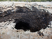 Length 3 miles (4.8 km); (round trip) Elevation change 200 feet (61 meters) Difficulty Easy Rating (1-5) ★★★★★ Selection of easily-explored volcanic features, close to Hwy 53: two lava caves, several collapses from other lava tubes, a lava trench and a crater. |
13. Falls Trail, Bandelier National Monument Length 1.5 miles (2.4 km) Elevation change 400 feet (122 meters) Difficulty Easy Rating (1-5) ★★★★★ Path downstream along Frijoles Canyon, from wooded surroundings around the visitor center into more desert-like terrain, ending at the brink of the Upper Falls. The trail once continued another mile to the Rio Grande, but flood damage has rendered this section inaccessible. |
14. Frijolito Loop Trail, Bandelier National Monument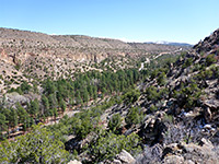 Length 2.5 miles (4 km); (loop) Elevation change 520 feet (158 meters) Difficulty Moderate Rating (1-5) ★★★★★ An unexcavated mesa top ruin (Frijolito) is visited by this lightly used loop trail which starts by switchbacking steeply up the south side of Frijoles Canyon to the wooded plateau above, and reaches the archeological site soon after. It continues northwest a little way further, close to the canyon rim, then returns via a section of the Long Trail. |
15. Headland Trail, El Morro National Monument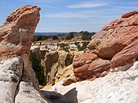 Length 2 miles (3.2 km); (round trip) Elevation change 210 feet (64 meters) Difficulty Moderate - steep ascent and descent Rating (1-5) ★★★★★ The Headland Trail starts with a paved portion (the Inscription Trail), along the base of the sandstone cliff bearing thousands of historical signatures and etchings, then ascends a little over 200 feet to the plateau above. It runs along the rim of a deep box canyon and past a reconstructed pueblo before descending back to the visitor center. |
16. La Junta Trail, Wild Rivers Recreation Area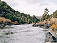 Length 1.2 miles (1.9 km) Elevation change 800 feet (244 meters) Difficulty Moderate Rating (1-5) ★★★★★ La Junta Trail is the best of the small number of paths in Wild Rivers Recreation Area; a steep, rocky route to the confluence of the Rio Grande and Red River, starting at the southern tip of the plateau between the two rivers. The far end has several shelters for primitive camping, before the trail meets the river's edge. Stairs and a short ladder help the steepest section of the descent. |
17. Las Conchas Trail, Jemez Mountains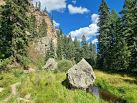 Length 1.8 miles (2.9 km) Elevation change 60 feet (18 meters) Difficulty Easy Rating (1-5) ★★★★★ Scenic path through a pretty section of the shallow canyon of the East Fork Jemez River, past floral meadows and ponderosa pine woodland, beneath colorful volcanic cliffs |
18. Lava Falls Trail, El Malpais National Monument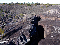 Length 1 mile (1.6 km); (loop) Elevation change 50 feet (15 meters) Difficulty Easy Rating (1-5) ★★★★★ This cairned loop path penetrates a little way into the most recent lava flow in the national monument. A trail guide is available, describing nine points of interest along the way. |
19. Main Loop Trail, Bandelier National Monument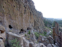 Length 1.2 miles (1.9 km) Elevation change 200 feet (61 meters) Difficulty Easy Rating (1-5) ★★★★★ This is the most popular path in Bandelier National Monument; a loop trail, partly paved, passing many ruins along the north side of Frijoles Canyon, the three main sites being Tyuonyi Pueblo, Talus House and Long House. The return is through woodland on the south side of the canyon - pretty surroundings with plentiful flowers, and the chance of glimpsing lizards, snakes and other wildlife. |
20. Penistaja Mesa, Penistaja Mesa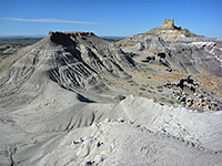 Length 4 miles (6.4 km); (round trip) Elevation change 200 feet (61 meters) Difficulty Easy Rating (1-5) ★★★★★ Little-visited region of grey badlands, eroded rock formations, petrified wood and varied plant life, 20 miles west of Cuba; no official trail, but explorable by easy cross-country walking, across slopes, ridges and ravines |
21. Piedras Marcadas Canyon Trail, Petroglyph National Monument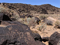 Length 1 mile (1.6 km) Elevation change 30 feet (9 meters) Difficulty Easy Rating (1-5) ★★★★★ Path into the least-visited section of Petroglyph National Monument, along a wide, branched valley containing several hundred petroglyphs on the north side |
22. Pine Tree Trail, Aguirre Spring Recreation Area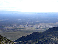 Length 4 miles (6.4 km); (loop) Elevation change 1100 feet (335 meters) Difficulty Moderate Rating (1-5) ★★★★★ Clockwise is the best direction for hiking the Pine Tree Trail; the path crosses several streamways and ridges while climbing high into the granite peaks of the Organ Mountains, for spectacular views of Tularosa Valley far below. The surface is rather stony and some of the steeper sections can be slippery, though overall the trail is well used and easy to follow. |
23. Pueblo Alto Trail, Chaco Culture National Historical Park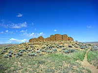 Length 5.1 miles (8.2 km); (loop) Elevation change 270 feet (82 meters) Difficulty Easy to moderate; steep at the beginning Rating (1-5) ★★★★★ This varied loop hike passes two lesser-known ruins (Kin Kletso and Pueblo Alto), the latter on the plateau on the north side of Chaco Wash. To reach here the path has a two-stage climb from the valley floor; it later turns east, then south along a narrowing promontory before returning to the trailhead right along the edge of the cliffs, giving good views of Chetro Ketl and Pueblo Bonito. |
24. Rinconada Canyon Trail, Petroglyph National Monument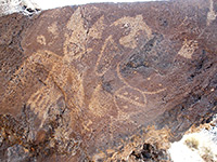 Length 2.2 miles (3.5 km); (round trip) Elevation change 100 feet (30 meters) Difficulty Easy Rating (1-5) ★★★★★ The popular loop path to the largest collection of petroglyphs in the national monument leads westwards along the north edge of Rinconada Canyon all the way to its upper end, then returns through grass and sagebrush in the middle. The ground is quite sandy underfoot so the walk can be slow, and hot in summer (up to 95°F), though there is no significant elevation change. |
25. Ruins Trail, Gila Cliff Dwellings National Monument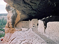 Length 1 mile (1.6 km); (loop) Elevation change 180 feet (55 meters) Difficulty Easy; just a few steep places Rating (1-5) ★★★★★ The five caves containing ancient ruins in Gila Cliff Dwellings National Monument may be viewed along a one mile loop trail, easy except for one short steep ascent. The path follows a narrow, overgrown, tree-lined streambed, crossing several times on wooden bridges and after 0.25 miles reaches a viewpoint of the dwellings, built quite high in the south-facing canyon wall. It then climbs 180 feet, above the trees and back across the base of the cliffs to the caves. |
26. South Mesa Trail, Chaco Culture National Historical Park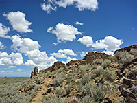 Length 4.4 miles (7.1 km); (loop) Elevation change 450 feet (137 meters) Difficulty Easy to moderate; some steep terrain Rating (1-5) ★★★★★ A crumbling backcountry ruin (Tsin Kletsin) is reached by this 4.4 mile loop trail that starts by climbing the cliffs on the south side of Chaco Wash then crosses the flat plateau beyond, to the ancient settlement. From here the route is west, down a side valley that leads to the larger South Gap, and finally north along an old vehicle track back to the trailhead. |
27. Tsankawi Trail, Bandelier National Monument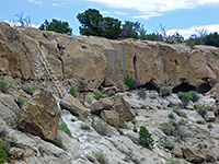 Length 1.5 miles (2.4 km); round trip Elevation change 200 feet (61 meters) Difficulty Easy to moderate; a few steep sections, with ladders in some places Rating (1-5) ★★★★★ The detached Tsankawi section of Bandelier National Monument (12 miles northwest along Hwy 4), can be explored by a short loop trail that climbs to the top of a grassy mesa, passing through an overgrown pueblo site, then returns along ledges a little way below the rim, within sight of many alcove ruins, petroglyphs and other ancient structures. Parts of the route follow ancient pathways, chiseled out of the soft volcanic bedrock. |
28. Tyuonyi Overlook Trail, Bandelier National Monument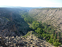 Length 1.1 miles (1.8 km) Elevation change 140 feet (43 meters) Difficulty Easy Rating (1-5) ★★★★★ From the national monument campground, this easy trail heads southeast across the pinyon-juniper plateau on the north side of Frijoles Canyon, out to the tip of a narrow promontory above Tyuonyi Ruin. There are several small unexcavated sites along the way. Views are extensive, all along the lower section of the canyon, both east and west. |
29. Wijiji Trail, Chaco Culture National Historical Park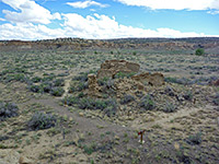 Length 1.5 miles (2.4 km) Elevation change 20 feet (6 meters) Difficulty Easy Rating (1-5) ★★★★★ Wijiji is a multi-room settlement along Chaco Wash, east of the park road, and may be viewed by a level trail along an old vehicle track, once the main park access route. The ruin dates from around 1100, later than many of the pueblos further west. Petroglyphs, pictographs and handprints may be viewed on the cliffs just north of the ruin. |
30. Yapashi Pueblo, Bandelier National Monument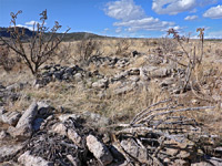 Length 6 miles (9.7 km) Elevation change 800 feet (244 meters) Difficulty Moderate to strenuous Rating (1-5) ★★★★★ Long, little-used path across grassy mesas and wooded ravines, including Alamo and Lummis canyons, to an unexcavated backcountry ruin, consisting of low walls and overgrown piles of stones, with many pottery fragments |
31. Zuni-Acoma Trail, El Malpais National Monument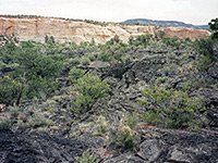 Length 7 miles (11.3 km) Elevation change 70 feet (21 meters) Difficulty Moderate Rating (1-5) ★★★★★ The Zuni-Acoma Trail is an ancient Indian route which crosses the vast lava field between NM 117 and NM 53, marked by cairns at closely-spaced intervals. The rock is very sharp and brittle so walking off trail needs care as the lava often has fissures several feet deep as well being generally unstable. Below the generally black surface, the rock has lighter, reddish-grey colors, due to a longer cooling time and less exposure |
All Contents © Copyright The American Southwest | Comments and Questions | Contribute | Affiliate Marketing Disclosure | Site Map