Highlights:
Multicolored sandstone cliffs concealing a deep pool that holds water all year; for many centuries an important location for cross-country travelers, who have left thousands of inscriptions on the surrounding rocks. Monument also has a reconstructed mesa top ruin
Nearby town:
Grants, 41 miles
Management:
Location:
Seasons:
Open all year. Trail to the mesa top closed by snow during winter and spring
Rating (1-5):
★★★★★

El Morro NM is part of the New Mexico Highlights itinerary
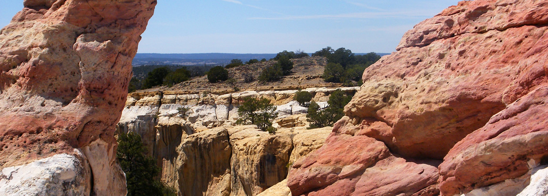
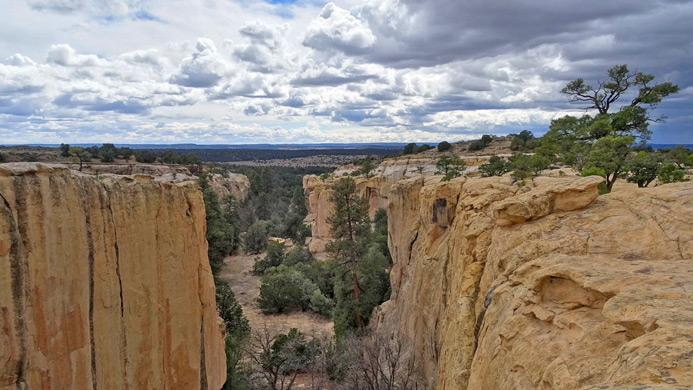
El Morro is one of New Mexico's smaller national monuments, hidden away in forested, high elevation, little-traveled land towards the northwest of the state, reached by NM 53 between Grants and Ramah. Some of the surroundings are volcanic, including nearby El Malpais National Monument on the far side of the continental divide, and other parts are featureless grassy plains, but El Morro is centered on a conspicuous, vertical-sided mesa of light-colored sandstone at the base of which sits a deep pour-over pool that provides a reliable, year-round source of drinking water and so has long been a focal point for cross country travelers in this otherwise rather arid and desolate country.
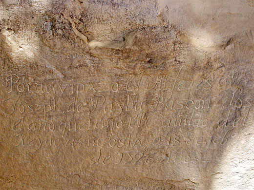
Over 2,000 drawings, signatures and messages have been inscribed in the soft sandstone cliffs (known as Inscription Rock) beside the pool, from three distinct periods - Ancestral Puebloans of up to 1,000 years ago, Spanish conquistadors from 1605 to around 1800, and American settlers after this time.
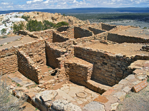
A paved, half mile trail leads to the inscriptions, many of which are crisp and easily legible due to varying degrees of preservation, and links with a longer loop along the mesa top, passing the ruins of an ancient pueblo, while giving fine, elevated views over the forested landscape. A campsite and visitor center complete the list of attractions, and although all can be seen in just a couple of hours, El Morro is an unusual and evocative place, well worth a detour to visit.
Over 2,000 drawings, signatures and messages have been inscribed in the soft sandstone cliffs (known as Inscription Rock) beside the pool, from three distinct periods - Ancestral Puebloans of up to 1,000 years ago, Spanish conquistadors from 1605 to around 1800, and American settlers after this time.
A paved, half mile trail leads to the inscriptions, many of which are crisp and easily legible due to varying degrees of preservation, and links with a longer loop along the mesa top, passing the ruins of an ancient pueblo, while giving fine, elevated views over the forested landscape. A campsite and visitor center complete the list of attractions, and although all can be seen in just a couple of hours, El Morro is an unusual and evocative place, well worth a detour to visit.
El Morro Table of Contents
Photographs
16 views of El Morro.
Features of the National Monument
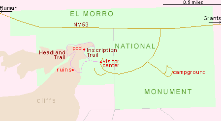
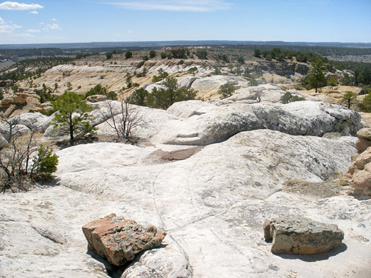
El Morro National Monument is small in extent, enclosing the mesa, the cliffs and a few square miles of woods and fields either side, including the nine site campground (no hookups). The short side road to the visitor center forks off NM 53, 42 miles west of Grants and 11 miles east of Ramah. The main trail, to the pool and inscriptions, is paved and starts from the visitor center, climbing slightly through pinyon pine woods to the foot of the Zuni sandstone cliffs, beside the waterhole, which is located in a sheltered, east-facing alcove. This is not a spring, instead being fed by run-off from rainfall and snowmelt on the slickrock plateau above, yet the hole is deep enough (ten feet or more) and sufficiently protected from the sun to hold water all year, even during summer droughts. The path turns east and runs right along the base of the mesa for 500 feet, past all the historical inscriptions. The cliffs are sheer, nearly 200 feet tall and unusually colorful, displaying an enchanting mixture of muted shades of orange, red, grey and white.
Inscriptions at El Morro
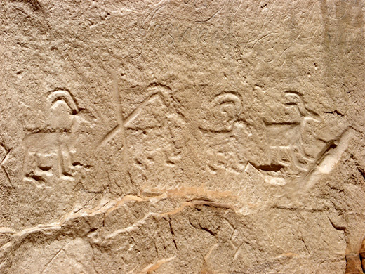
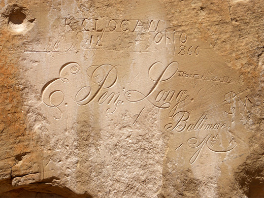
Oldest and least numerous of the inscriptions are the petroglyphs, from the Ancestral Puebloan (Anasazi) peoples of ca 1000 to 1400; the majority are now faded and indistinct but some are still prominent, such as a neat row of bighorn sheep. Spanish carvings start with Jean de Onate in 1605 and continue for the next 200 years - other notable Hispanic travelers are Don Feliz Martinez, Pedro Romero and Ramon Garcia Jurado. The American inscriptions range from the initial settlement of the West to the railroad building of the late 19th century; most stop soon after 1900 (the monument was created in 1906), and subsequent protection efforts have been successful, unlike some similar sites (Independence Rock, Hueco Tanks), where modern graffiti has been added. Some of the earliest writings at El Morro are still clear and easy to read since various methods of preservation have been employed, some now disapproved for example coloring with a black pencil, or chiseling drainage channels above. The greatest concentration of inscriptions, mostly fairly recent, is on the east corner of the rock, where dozens of signatures have been added, many within neat, polished rectangles and some quite high up; a lot of these are from the railroad builders. All the rock face is loosely fenced off for protection but it is easy to step across for a closer look. There are numerous faint, indecipherable inscriptions between the featured ones, some of which have elaborate, ornate script styles.
Headland Trail
| El Morro - one of the 20 least visited national monuments in the West |
El Morro - Nearby Places
- El Malpais National Monument (15 miles) - extensive deposits of black, twisted lava, and other volcanic formations
- Route 66 (41 miles to Grants) - long stretch of the famous old road
El Morro - Similar Places
- Hovenweep National Monument - cliff top pueblo ruins in southeast Utah
- Independence Rock State Historic Site, Wyoming - granite outcrop with pioneer inscriptions
All Contents © Copyright The American Southwest | Comments and Questions | Contribute | Affiliate Marketing Disclosure | Site Map