Other Activities in Carlsbad Caverns National Park
New Mexico > Carlsbad Caverns National Park > Other Activities
Highlights:
Activities away from the main caverns - hiking trails, backcountry caves and a scenic drive, plus a picnic area at Rattlesnake Springs

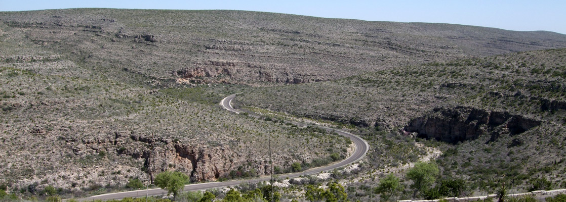
The Desert Loop Drive is a one-way route starting near the visitor center and rejoining the park road lower down Walnut Canyon; it is maintained and not too narrow yet is not open to vehicles longer than 20 feet. Along the way are numbered stops corresponding to particular points of interest, described in a tour guide available for purchase at the visitor center.
Carlsbad Caverns Table of Contents
Map
Map of Carlsbad Caverns National Park.
Rattlesnake Springs
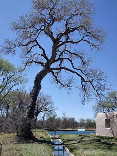
The other principal access point for the park backcountry is along a road starting along US 62/180, 5.5 miles south of Whites City, and crossing flattish, scrub-covered land for 11 miles, as far as a parking area and trailhead at the mouth of Slaughter Canyon. En route is a short track to Rattlesnake Springs, a detached section of the national park containing a group of natural springs that sustain a cool, moist area with large cottonwood trees and other vegetation, fed by a network of concrete irrigation channels, regulated by iron drawbridges. The NPS maintain a pleasant if little-used picnic area here (no camping, however), and the wetlands hereabouts are a good location for bird watching.
Backcountry Caverns
The latter part of the road to Slaughter Canyon is unpaved though still in good condition. This valley is the location of many of the backcountry caves - the national park contains over 110, of which most are not open to the public, and their locations are kept secret. Even trailhead directions for the few which are open are difficult to obtain, but most are found along the lower 2.5 miles of Slaughter Canyon, before it splits into West, Middle and North forks. One for which guided tours are provided is Slaughter Canyon Cave (formerly known as New Cave), reached by a half mile trail from the parking area, climbing 500 feet up the west side of the valley. Tours are available daily, lasting 2 hours and costing $15 per person. Apart from Carlsbad Cavern itself, the only other cave with a regular guided tour is the narrow Spider Cave, near the visitor center, while those open for self-exploration by qualified cavers include Chimney Cave (reached by a short trail along the Desert View Drive), Deep Cave (in the far southwest, reached by a 4WD track across the Lincoln National Forest), and a group in Slaughter Canyon: Christmas Tree, Goat, Helen, Ogle, Wen and Lake. There is definitely no public entry to the beautiful, recently discovered (1986) Lechuguilla Cave owing to its delicate formations, extreme environment and rare geology, but continuing investigations by NPS-approved explorers have taken the length of the known passages to over 120 miles, and to depths of 1,600 feet - making Lechuguilla the deepest cave in the USA and the fifth longest in the world.
Trails of Carlsbad Caverns National Park
|
Canyon Overlook Length 0.1 miles (0.2 km) Elevation change level Trailhead Along the park entrance road Rating (1-5) ★★★★★ Starting along the park entrance road one mile before the visitor center, this very short path leads to an overlook of Walnut Canyon, past examples of desert plants such as acacia, juniper, opuntia and cholla. |
|
Chihuahuan Desert Length 0.5 miles (.8 km) (loop) Elevation change level Trailhead East side of the main parking area Rating (1-5) ★★★★★ The Chihuahuan Desert Nature Trail loops around the plateau top just east of the visitor center, passing many examples of the local plants. A spur leads to a fenced-off shaft that provides an alternative natural entrance to Carlsbad Cavern. |
|
Guadalupe Ridge Length 12 miles (19.3 km) Elevation change 2000 feet (610 meters) Trailhead Half way along the one-way Desert Loop Drive Rating (1-5) ★★★★★ Carlsbad's longest trail (an old vehicle track) begins along the Desert Loop Drive, leading up the far end of Walnut Canyon for a mile or so then ascending to Guadalupe Ridge, a high, narrow escarpment that is followed all the way to the western park boundary, and on into the adjacent Lincoln National Forest. |
|
Guano Road Length 3.7 miles (6 km) Elevation change 700 feet (213 meters) Trailhead Whites City campground Rating (1-5) ★★★★★ An old road once used by bat guano miners in the early 1900s now provides hikers with an alternative route between Whites City and Carlsbad Cavern; beginning at the Whites City campground, the path climbs quite steeply up a ravine, then becomes fairly level, traversing the top of the plateau and eventually meeting the paved path to the Natural Entrance. |
|
Juniper Ridge Length 3 miles (4.8 km) Elevation change 800 feet (244 meters) Trailhead Along the one-way Desert Loop Drive Rating (1-5) ★★★★★ About 8.5 miles down the one-way Desert Loop Drive, a trail forks off to the north, climbing fairly gently over open ground to a ridge on the northern park boundary. Walking east along here leads to a viewpoint of several twisting canyons. |
|
Rattlesnake Canyon Length 3 miles (4.8 km) Elevation change 650 feet (198 meters) Trailhead Half way along the one-way Desert Loop Drive Rating (1-5) ★★★★★ Rattlesnake Canyon is a large drainage in the center of the national park, accessed by a trail starting at the westernmost tip of the Desert Loop Drive. The path descends a side ravine to the wide, stony wash running through the main gorge; downstream, the route passes an old homestead and reaches the edge of the mountains, where it intersects a vehicle track that enters private land. |
|
Slaughter Canyon Length 5.3 miles (8.5 km) Elevation change 1850 feet (564 meters) Trailhead Slaughter Canyon Road Rating (1-5) ★★★★★ The first couple of miles of the Slaughter Canyon Trail give access to many of Carlsbad's backcountry caves; the route goes up the canyon, past the junction with the West Fork, then turns right, up the North Fork towards Goat Cave. The final section climbs the hillside to the west, and ends at a junction with the Guadalupe Ridge Trail. Parking for the hike is at the end of an 11 mile road, partly unpaved, that forks off Hwy 62/180 5.5 miles south of Whites City. |
|
Yucca Canyon Length 7.7 miles (12.4 km) Elevation change 1500 feet (457 meters) Trailhead End of a track forking west off Slaughter Canyon Road Rating (1-5) ★★★★★ Accessed by a rather rough 2 mile track forking west off the road to Slaughter Canyon as it crosses the park boundary, the Yucca Canyon Trail climbs a short but steep ravine to the partly wooded plateau top then stays fairly level for the next 5 miles as it follows the ridge westwards, meeting another path (Double Trail) that continues into the Lincoln National Forest. |
All Contents © Copyright The American Southwest | Comments and Questions | Contribute | Affiliate Marketing Disclosure | Site Map