Falls Trail, Bandelier National Monument
New Mexico > Bandelier National Monument > Hiking > Falls Trail
Falls Trail
Path downstream along Frijoles Canyon, from wooded surroundings around the visitor center into more desert-like terrain, ending at the brink of the Upper Falls. The trail once continued another mile to the Rio Grande, but flood damage has rendered this section inaccessible
Length: 1.5 miles
Elevation change: 400 feet
Difficulty: Easy
Type: One way
Usage: Medium
Season: All year
Trailhead: Backpacker/ overflow parking area
Rating (1-5): ★★★★★
Elevation change: 400 feet
Difficulty: Easy
Type: One way
Usage: Medium
Season: All year
Trailhead: Backpacker/ overflow parking area
Rating (1-5): ★★★★★

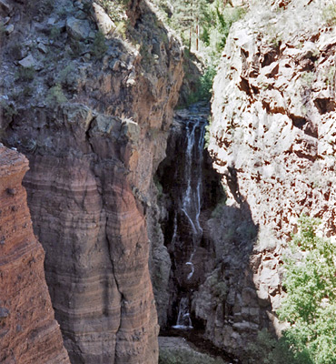
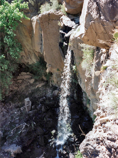
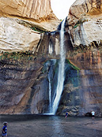
From cool, shady woodland around the Bandelier National Monument visitor center, the 1.5 mile Falls Trail follows Frijoles Canyon downstream, descending gently by 400 feet, to the more desert-like conditions at the brink of the Upper Falls, a 90 foot waterfall on Frijoles Creek.
Varied scenery and wildlife make this a popular route, even though the hike has been significantly shortened following a huge flash flood in August 2011; the path used to continue a further mile, descending another 300 feet, past a second waterfall, to grassy flats bordering the Rio Grande. The flood washed away a short section of the path where it traversed a sheer cliff face just below the Upper Falls, and because of the high cost of repair it was decided not to proceed, so the lower end of the canyon, and the Rio Grande, will remain permanently inaccessible.
Map of Bandelier National Monument.
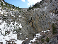
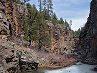
The Falls Trail begins at the south end of the backpackers parking lot and follows the south side of Frijoles Creek, soon arriving at the Tent Rocks - curious pointed columns of tuff that formed around volcanic vents. Around here, bushes and agaves start to replace the pine trees as the canyon deepens and the temperature rises; this effect is particularly noticeable at one point after about one mile where the path rounds a bend and changes direction; there is an abrupt switch to open country with many cacti and other desert plants. By this stage, the canyon has eroded through the light-colored tuff layers, in which the Anasazi dwellings upstream were carved, into the much darker and harder layers of underlying basalt. For the most part, the path stays generally quite far above the creek, which becomes enclosed in several deep, narrow channels. Many whiptail lizards inhabit the canyon; other commonly-spotted wildlife include snakes, deer and several types of brightly-colored birds.
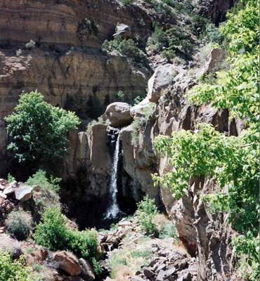
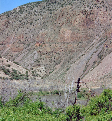
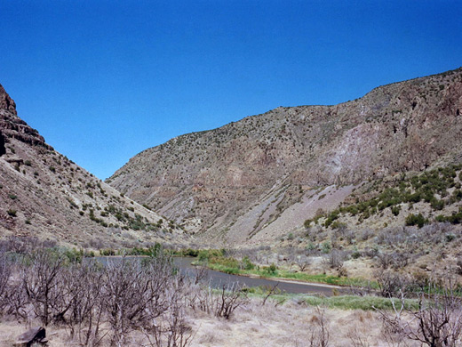
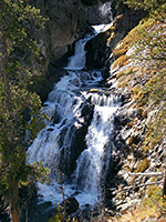
After about 1.4 miles the trail reaches a viewpoint of the Upper Falls, which are somewhat hidden and in shadow for most of the day. Here the hike ends; the now-closed continuation path can be seen descending the basalt walls on the east side of the canyon, heavily undercut at first, then completely missing lower down. Beyond, the former route continued descending and crossed the stream shortly above the Lower Falls then ran close to the creek, through bushes and long grass, before the confluence with the Rio Grande. The river hereabouts is slow moving, flowing through a V-shaped canyon with sparse vegetation and unusual, differently colored rock walls; generally the area around the junction is quite barren-looking and has a great feeling of remoteness. A rough path follows the Rio Grande south though White Rock Canyon eventually leading to Cochiti Lake after 14 miles. Nearby is the Cochiti pueblo, whose inhabitants claim descent from the Anasazi cave-dwellers of Frijoles Canyon.
Varied scenery and wildlife make this a popular route, even though the hike has been significantly shortened following a huge flash flood in August 2011; the path used to continue a further mile, descending another 300 feet, past a second waterfall, to grassy flats bordering the Rio Grande. The flood washed away a short section of the path where it traversed a sheer cliff face just below the Upper Falls, and because of the high cost of repair it was decided not to proceed, so the lower end of the canyon, and the Rio Grande, will remain permanently inaccessible.
Location
Map of Bandelier National Monument.
The Trail
The Falls Trail begins at the south end of the backpackers parking lot and follows the south side of Frijoles Creek, soon arriving at the Tent Rocks - curious pointed columns of tuff that formed around volcanic vents. Around here, bushes and agaves start to replace the pine trees as the canyon deepens and the temperature rises; this effect is particularly noticeable at one point after about one mile where the path rounds a bend and changes direction; there is an abrupt switch to open country with many cacti and other desert plants. By this stage, the canyon has eroded through the light-colored tuff layers, in which the Anasazi dwellings upstream were carved, into the much darker and harder layers of underlying basalt. For the most part, the path stays generally quite far above the creek, which becomes enclosed in several deep, narrow channels. Many whiptail lizards inhabit the canyon; other commonly-spotted wildlife include snakes, deer and several types of brightly-colored birds.
Upper Frijoles Falls
After about 1.4 miles the trail reaches a viewpoint of the Upper Falls, which are somewhat hidden and in shadow for most of the day. Here the hike ends; the now-closed continuation path can be seen descending the basalt walls on the east side of the canyon, heavily undercut at first, then completely missing lower down. Beyond, the former route continued descending and crossed the stream shortly above the Lower Falls then ran close to the creek, through bushes and long grass, before the confluence with the Rio Grande. The river hereabouts is slow moving, flowing through a V-shaped canyon with sparse vegetation and unusual, differently colored rock walls; generally the area around the junction is quite barren-looking and has a great feeling of remoteness. A rough path follows the Rio Grande south though White Rock Canyon eventually leading to Cochiti Lake after 14 miles. Nearby is the Cochiti pueblo, whose inhabitants claim descent from the Anasazi cave-dwellers of Frijoles Canyon.
Falls Trail - Similar Hikes
All Contents © Copyright The American Southwest | Comments and Questions | Contribute | Affiliate Marketing Disclosure | Site Map