Lower Calf Creek Falls, Grand Staircase-Escalante National Monument
Utah > Grand Staircase-Escalante National Monument > Lower Calf Creek Falls

Lower Calf Creek Falls
Popular path that follows a sheer-walled riparian canyon, either close to the stream or across more arid land above, to a dramatic waterfall in a sheltered alcove
Length: 2.75 miles
Elevation change: 200 feet
Difficulty: Easy
Type: One way, maintained trail
Usage: High
Season: All year
Trailhead: Calf Creek Recreation Area;
Rating (1-5): ★★★★★
Elevation change: 200 feet
Difficulty: Easy
Type: One way, maintained trail
Usage: High
Season: All year
Trailhead: Calf Creek Recreation Area;
Rating (1-5): ★★★★★

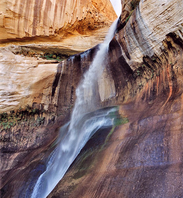
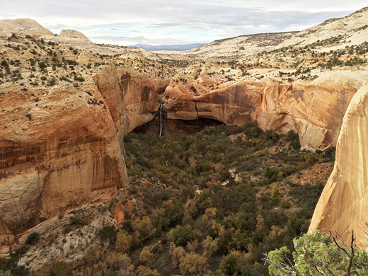
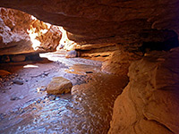
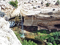
The lower falls of Calf Creek were for many years one of the hidden, little visited attractions of south Utah but since the creation of Grand Staircase-Escalante National Monument they have become quite well known. At the falls, the creek emerges from a V-shaped channel at the end of upper Calf Creek Canyon and cascades over a near-vertical cliff face into a large pool several feet deep, enclosed on three sides by sheer Navajo sandstone walls. Rocks closest to the water are covered in delicate patches of blue and green algae, all the nearby cliffs have long streaks of desert varnish and the whole scene is extremely beautiful.
Although the falls are just 300 meters from UT 12, they can be viewed at this point only by a rather difficult climb down a steep gradient into the upper canyon. The usual access is along a 2.75 mile path that starts from the popular campsite at the BLM-managed Calf Creek Recreation Area - the first place where the canyon walls become less steep allowing the main road to descend to creek level, where it remains for the next one mile south until Calf Creek meets the Escalante River. In summer, the campground and parking area may fill up by early afternoon, necessitating a drive along the main road to the nearest lay-by, and consequently a longer hike.
8 views along the Lower Calf Creek Falls Trail.
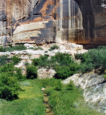
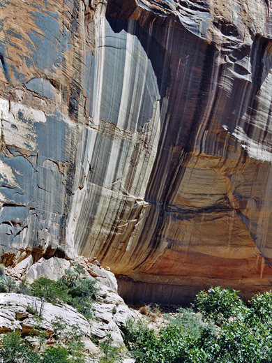
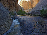
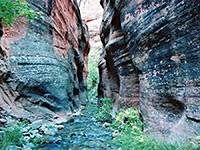
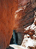
There is little overall elevation change along the path but it has some short, steep sections, is often unshaded and has a surface of mostly soft sand so the journey can be quite strenuous, and quite a few who set out turn back before reaching the waterfall. The round trip takes 3-4 hours according to the trailguide (a useful, illustrated pamphlet describing 24 points of interest), but under 2 hours if walking quickly. The route is along the west side of the creek, generally above the canyon floor which is covered by large areas of reeds and thick grass. It passes three Indian petroglyph sites and two ruined stone-built granaries, tucked away in alcoves in cliffs at the far side. After rounding the end of a side canyon at mile 1.8, the path descends closer to the stream and is more shaded, as the canyon walls become steeper and the route passes through woodland. One section of the cliffs has especially pretty streaks of desert varnish - the colorful patination formed by gradual deposition of iron-containing minerals by evaporating rainfall.
Calf Creek Falls are heard some distance away but are hidden from view until right near the end. Either side of the main cascade, an elongated seep between two rock layers sustains a band of greenery, and there are other small pools nearby plus a large marshy area; these moist, sheltered conditions support a variety of fish and other wildlife, including beaver and quite numerous grass snakes. The falls face southeast and are quite enclosed so are in shadow for most of the day - the best time to arrive is mid morning.
Although the falls are just 300 meters from UT 12, they can be viewed at this point only by a rather difficult climb down a steep gradient into the upper canyon. The usual access is along a 2.75 mile path that starts from the popular campsite at the BLM-managed Calf Creek Recreation Area - the first place where the canyon walls become less steep allowing the main road to descend to creek level, where it remains for the next one mile south until Calf Creek meets the Escalante River. In summer, the campground and parking area may fill up by early afternoon, necessitating a drive along the main road to the nearest lay-by, and consequently a longer hike.
Photographs
8 views along the Lower Calf Creek Falls Trail.
Trail to the Falls
There is little overall elevation change along the path but it has some short, steep sections, is often unshaded and has a surface of mostly soft sand so the journey can be quite strenuous, and quite a few who set out turn back before reaching the waterfall. The round trip takes 3-4 hours according to the trailguide (a useful, illustrated pamphlet describing 24 points of interest), but under 2 hours if walking quickly. The route is along the west side of the creek, generally above the canyon floor which is covered by large areas of reeds and thick grass. It passes three Indian petroglyph sites and two ruined stone-built granaries, tucked away in alcoves in cliffs at the far side. After rounding the end of a side canyon at mile 1.8, the path descends closer to the stream and is more shaded, as the canyon walls become steeper and the route passes through woodland. One section of the cliffs has especially pretty streaks of desert varnish - the colorful patination formed by gradual deposition of iron-containing minerals by evaporating rainfall.
The Falls
Calf Creek Falls are heard some distance away but are hidden from view until right near the end. Either side of the main cascade, an elongated seep between two rock layers sustains a band of greenery, and there are other small pools nearby plus a large marshy area; these moist, sheltered conditions support a variety of fish and other wildlife, including beaver and quite numerous grass snakes. The falls face southeast and are quite enclosed so are in shadow for most of the day - the best time to arrive is mid morning.
Lower Calf Creek Falls - Similar Hikes
All Contents © Copyright The American Southwest | Comments and Questions | Contribute | Affiliate Marketing Disclosure | Site Map