Death Hollow, Grand Staircase-Escalante National Monument
Utah > Grand Staircase-Escalante National Monument > Death Hollow
Death Hollow
Off trail hike into the lower end of Death Hollow, a deep canyon through sheer Navajo sandstone cliffs, containing a permanent stream. The route is down steep cliffs into the larger Escalante River canyon, then upstream a way to the confluence with the target drainage
Length: 2 miles to the lower end of the canyon, which can be followed for many miles northwards
Elevation change: 600 feet
Difficulty: Moderate; steep descent over slickrock to reach the Escalante, then wading in the canyons
Type: One way, off trail
Usage: Low
Season: Late spring, summer, fall - when water levels are low
Trailhead: End of a 1.6 mile dirt track forking north off UT 12
Rating (1-5): ★★★★★

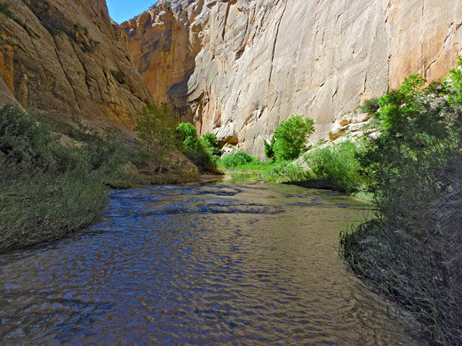
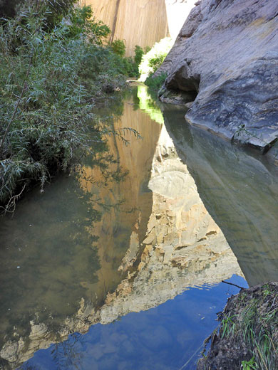
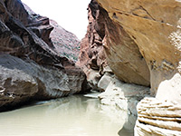
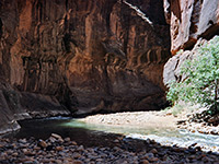
At over 20 miles, Death Hollow is one of the longest Escalante River tributaries; a permanent stream flowing through a deep, richly colored Navajo sandstone canyon containing innumerable pools, cascades and small waterfalls, and for most of its length is quite enclosed, by vertical cliffs up to 500 feet tall. The drainage starts high on the forested slopes of Boulder Mountain at 9,000 feet elevation, descends steeply in the upper stretches then more gently lower down, joining the Escalante River at 5,400 feet, at a point half way between the town of Escalante and the UT 12 highway crossing.
A trip into Death Hollow can begin from either of the two locations along the Escalante River, or from two places further north - one is reached via the unpaved Hell's Backbone Road, usually passable between May and October, which crosses the very upper end of the canyon, after a drive of 23.5 miles from Escalante or 15.5 miles from UT 12. The other is via the Boulder Mail Trail - prior to the highway construction this was the main route between Escalante and Boulder, traversing much open slickrock while descending in and out of three major drainages including Death Hollow, which is reached after a walk of 8.2 miles from Escalante or 5.6 miles from a trailhead west of UT 12.
All these routes involve a long hike of one or more days, and/or a car shuttle, but a shorter option is a there-and-back hike into the lowest, deepest part of Death Hollow, accessed by descending into the Escalante River canyon just downstream of the confluence, after driving 1.6 miles along a dirt track that forks northwards off UT 12; this is the hike described below. Note there is another canyon in the Escalante area with a similar name, but quite a different character; Little Death Hollow is a much narrower drainage, a tight slot for a mile or so, and usually dry.
Topographic map of lower Death Hollow.
21 views of Death Hollow.
Scenes in the canyon (mp4; 0:50 min; 16 mb).
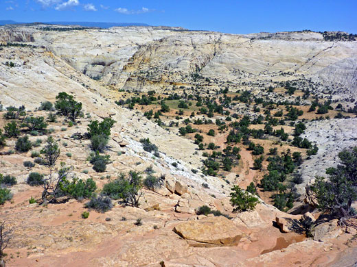
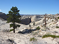
The unsignposted track leading towards the Escalante River leaves UT 12 between mileposts 66 and 67 in the middle of Big Flat, a sandy plateau covered by grass and scattered trees. The 1.6 mile road is level but narrow, and the surface is soft, so the track is subject to washouts after heavy rain, and is liable to be deeply rutted at any time. Keeping right at two junctions, the track ends at a rocky area on the rim of a short side ravine, with the Escalante River canyon visible beyond, enclosed by huge white domes and cliffs. This is a scenic and peaceful place to spend the night.
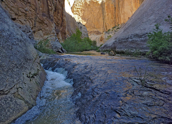
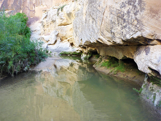
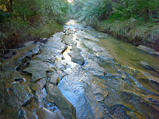
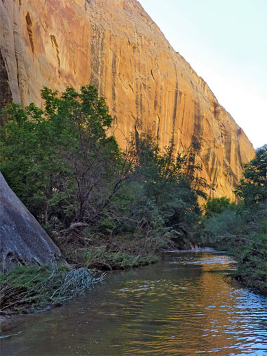
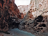
Most parts of the 700 foot deep Escalante River canyon are too sheer to climb down, but the route used to reach the lower end of Death Hollow is relatively easy - a steep walk down a slickrock slope, requiring use of hands in just a few places. The directions are to head northwards along the west rim of the side drainage, descending in and out of a ravine then along flat benches and out to a white rock promontory overlooking the Escalante River and the lower end of the side drainage (which forms a short, very narrow slot canyon). Next is a traverse westwards for a few hundred feet until the slope below becomes less steep, centered on a long vertical fault in the sandstone, which provides good footholds when descending. This leads most of the way down the cliffs, to a sandy gully, then the route is completed by climbing over a low ridge and walking down a sandy, boulder-strewn hill to the river, here flowing through a shady corridor of trees and bushes. Death Hollow joins the Escalante just half a mile upstream, and walking is easiest in the water, usually just a few inches deep, flowing over bare rock or pebbles.
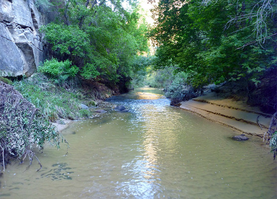
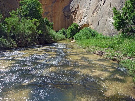
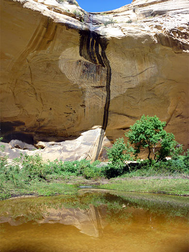
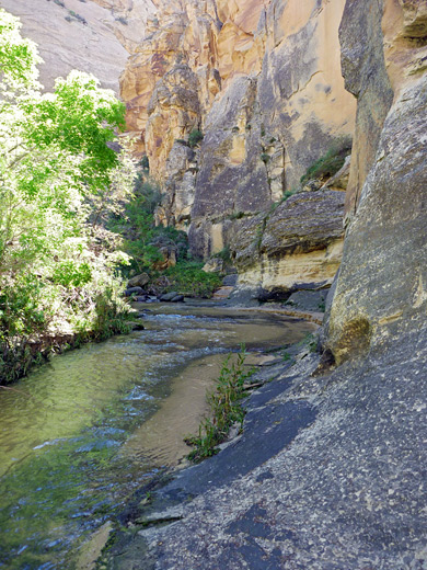
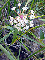
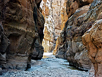
The clear water in Death Hollow is a little deeper than in the Escalante upstream of the confluence, and faster-moving, but still (for most of the year) presents no problems when hiking up the canyon. Although the lower reaches are quite overgrown, with willow, cottonwood, oak, bamboo and poison ivy, plus a multitude of summer wildflowers, there are paths across the sand banks at either side of the streamway, so progress is relatively fast. Some parts of the creekbed are soft and sandy, separated by long stretches where the water flows over the bedrock, occasionally forming small cascades and waterfalls, sometimes with sheer , overhanging cliffs at one side. A small drainage joins from the west after 0.7 miles, flowing over a streaked cliff into a large pool, but otherwise there are no major landmarks in the lower canyon, which starts to curve around some sharp bends, whilst gaining height only slightly, hence lacking any deeper pools or bigger falls. These lower stretches are not particularly narrow though the canyon does constrict somewhat after about 2 miles, and for a short distance the creek is enclosed within a subway-like channel with potholes and cascades.
A trip into Death Hollow can begin from either of the two locations along the Escalante River, or from two places further north - one is reached via the unpaved Hell's Backbone Road, usually passable between May and October, which crosses the very upper end of the canyon, after a drive of 23.5 miles from Escalante or 15.5 miles from UT 12. The other is via the Boulder Mail Trail - prior to the highway construction this was the main route between Escalante and Boulder, traversing much open slickrock while descending in and out of three major drainages including Death Hollow, which is reached after a walk of 8.2 miles from Escalante or 5.6 miles from a trailhead west of UT 12.
All these routes involve a long hike of one or more days, and/or a car shuttle, but a shorter option is a there-and-back hike into the lowest, deepest part of Death Hollow, accessed by descending into the Escalante River canyon just downstream of the confluence, after driving 1.6 miles along a dirt track that forks northwards off UT 12; this is the hike described below. Note there is another canyon in the Escalante area with a similar name, but quite a different character; Little Death Hollow is a much narrower drainage, a tight slot for a mile or so, and usually dry.
Map
Topographic map of lower Death Hollow.
Photographs
21 views of Death Hollow.
Video
Scenes in the canyon (mp4; 0:50 min; 16 mb).
Big Flat Access
The unsignposted track leading towards the Escalante River leaves UT 12 between mileposts 66 and 67 in the middle of Big Flat, a sandy plateau covered by grass and scattered trees. The 1.6 mile road is level but narrow, and the surface is soft, so the track is subject to washouts after heavy rain, and is liable to be deeply rutted at any time. Keeping right at two junctions, the track ends at a rocky area on the rim of a short side ravine, with the Escalante River canyon visible beyond, enclosed by huge white domes and cliffs. This is a scenic and peaceful place to spend the night.
Route to Death Hollow
Most parts of the 700 foot deep Escalante River canyon are too sheer to climb down, but the route used to reach the lower end of Death Hollow is relatively easy - a steep walk down a slickrock slope, requiring use of hands in just a few places. The directions are to head northwards along the west rim of the side drainage, descending in and out of a ravine then along flat benches and out to a white rock promontory overlooking the Escalante River and the lower end of the side drainage (which forms a short, very narrow slot canyon). Next is a traverse westwards for a few hundred feet until the slope below becomes less steep, centered on a long vertical fault in the sandstone, which provides good footholds when descending. This leads most of the way down the cliffs, to a sandy gully, then the route is completed by climbing over a low ridge and walking down a sandy, boulder-strewn hill to the river, here flowing through a shady corridor of trees and bushes. Death Hollow joins the Escalante just half a mile upstream, and walking is easiest in the water, usually just a few inches deep, flowing over bare rock or pebbles.
The Canyon
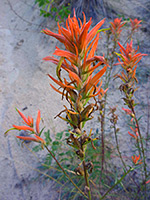
The clear water in Death Hollow is a little deeper than in the Escalante upstream of the confluence, and faster-moving, but still (for most of the year) presents no problems when hiking up the canyon. Although the lower reaches are quite overgrown, with willow, cottonwood, oak, bamboo and poison ivy, plus a multitude of summer wildflowers, there are paths across the sand banks at either side of the streamway, so progress is relatively fast. Some parts of the creekbed are soft and sandy, separated by long stretches where the water flows over the bedrock, occasionally forming small cascades and waterfalls, sometimes with sheer , overhanging cliffs at one side. A small drainage joins from the west after 0.7 miles, flowing over a streaked cliff into a large pool, but otherwise there are no major landmarks in the lower canyon, which starts to curve around some sharp bends, whilst gaining height only slightly, hence lacking any deeper pools or bigger falls. These lower stretches are not particularly narrow though the canyon does constrict somewhat after about 2 miles, and for a short distance the creek is enclosed within a subway-like channel with potholes and cascades.

Death Hollow - Similar Hikes
All Contents © Copyright The American Southwest | Comments and Questions | Contribute | Affiliate Marketing Disclosure | Site Map