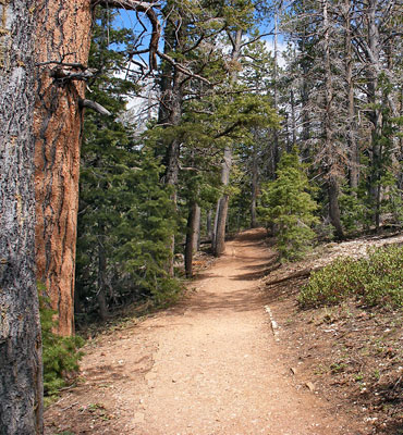
Trails and Hikes in Utah

 For details of all Utah trails featured on this website, see the listings pages:
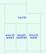
North (12), including Uinta Mountains and Dinosaur National Monument
South Central (75), including Bryce Canyon, Capitol Reef and Grand Staircase-Escalante National Monument
Southeast (89), including Arches, Canyonlands, Cedar Mesa, Lake Powell and the San Rafael Swell
Southwest (48), including Snow Canyon State Park and Zion National Park
Top Ten Trails
Below are suggestions for the top ten hikes in Utah, in alphabetical order. Five are from Zion National Park, two in Canyonlands National Park, one in Bryce Canyon National Park; the others are two narrow canyons (Buckskin Gulch and the Paria River).
 Length 13.5 miles (21.7 km), elevation change 900 feet (274 meters); Wire Pass entrance to the Paria confluence Difficulty Moderate; few major obstacles apart from long muddy pools, but the full hike is long and tiring. High flash flood danger Rating 1-5) ★★★★★ Longest and deepest slot canyon in the Southwest - intimidating, sheer-walled narrows that extend for 12 miles, meeting the Paria River in the middle of its own lengthy enclosed section. The whole canyon can be hiked in one day, though camping en route for one night is more common. |
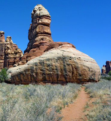
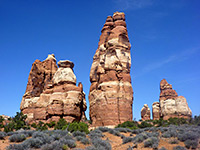 Length 3 miles (4.8 km), elevation change 0 feet (0 meters); level overall Difficulty Moderate Rating 1-5) ★★★★★ This path passes varied terrain, across Elephant Canyon to the edge of Chesler Park - an unspoilt meadow ringed by the colorful, jagged rocks of the Needles. The first viewpoint is reached after 3 miles, from where another trail circles the edge of the meadow. One of several other routes radiating from the park is the Joint Trail, which winds southwards through cool, narrow passages between vertical rocks. |
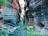 Length 2.9 miles (4.7 km), elevation change 800 feet (244 meters); to the upper end of the narrows Difficulty Moderate; some deep pools to wade and several large chokestones to climb, using improvised ladders Rating 1-5) ★★★★★ Beautiful, deep and narrow red rock canyon containing a permanent stream, fairly shallow for most of the year, forming pretty pools, waterfalls and flooded channels. |
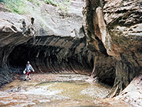 Length 3.4 miles (5.5 km), elevation change 1200 feet (366 meters); to the Subway Difficulty Easy to moderate; obstacles begin just above the Subway Rating 1-5) ★★★★★ Popular, oft-visited narrow canyon that includes The Subway, where the creek flows through a long, tubular passage with only a narrow opening above. Further upstream are deep pools and drop-offs that may be seen (with use of ropes) if starting from an alternative trailhead, but most just explore the lower narrows. |
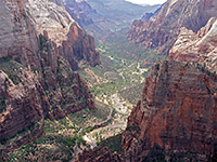 Length 4 miles (6.4 km), elevation change 2150 feet (655 meters) Difficulty Strenuous Rating 1-5) ★★★★★ The actual Observation Point Trail is only 0.25 miles long - a spur off the East Mesa Trail - though the hike to the viewpoint is a 4 mile trip beginning at Weeping Rock on the floor of Zion Canyon. The first part of the route is the same as for Echo Canyon, followed by an steep ascent above the canyon to the plateau (on the East Mesa Trail), then the short walk west to the 6,508 foot viewpoint. This rivals Angels Landing on the opposite side of the canyon for the best views in the park. |
 Length 8.4 miles (13.5 km), elevation change 1700 feet (518 meters); to Zion Canyon Difficulty Moderate - pools and chokestones towards the lower end Rating 1-5) ★★★★★ Spectacular, long and very deep gorge joining the Zion Narrows. The lower 3 miles are most impressive, and part contains a permanent stream, with pools, waterfalls and several huge chokestones. |
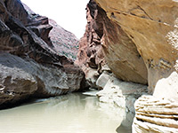 Length 7 miles (11.3 km), elevation change 300 feet (91 meters); to the Buckskin Gulch confluence Difficulty Easy, but long; no significant obstructions. High flash flood danger Rating 1-5) ★★★★★ Rival of the Zion Narrows to be the best narrow, water-filled canyon in the Southwest - a usually shallow river flowing through miles of enclosed passageways between sheer cliffs up to 1,000 feet high. The wider gorge below the narrows has other interesting sites including arches and petroglyphs. |
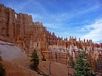 Length 5.5 miles (8.8 km), elevation change 900 feet (274 meters); (loop) Difficulty Moderate; many short, steep ascents and descents Rating 1-5) ★★★★★ Starting from Bryce Point, the Peekaboo Loop Trail is one of the longer routes through the largest area of hoodoos in the national park, around the upper end of Bryce Canyon; it drops down very steeply from the plateau edge then winds amongst innumerable colorful formations. The path is shared by horses, which can sometimes cause delays for hikers. The route may also be accessed from Sunset Point via the Navajo Trail, or by a longer walk from Sunrise Point along the Queens Garden Trail. |
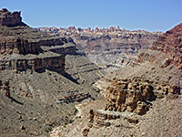 Length 9.5 miles (15.3 km), elevation change 1600 feet (488 meters) Difficulty Strenuous Rating 1-5) ★★★★★ The only direct route to the Colorado River in the Needles is along Lower Red Lake Canyon, 2 miles south of the confluence with the Green River. The path begins along the Devils Lane road, just east of Cyclone Canyon, a point reached either by hiking from Big Spring Canyon Overlook, or (slightly shorter) by 4WD vehicle or on foot starting from the Elephant Hill trailhead. Lower Red Lake is a deep, overgrown, rocky but quite short canyon, without any obstructions, that meets the Colorado just upstream of the start of the rapids in Cataract Canyon. The round trip to the river is normally done over 2 days. |
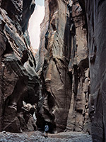
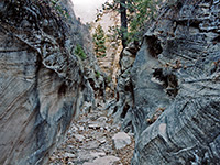
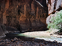 Length 15.6 miles (25.1 km), elevation change 1200 feet (366 meters); for the whole canyon Difficulty Moderate; no great obstacles, but miles of wading in the river Rating 1-5) ★★★★★ The most famous narrow canyon hike in the Southwest, following the North Fork of the Virgin River past near vertical walls up to 2,000 feet high. Generally passable only during late summer and fall, as the water is too deep and fast flowing at other times. The full canyon is best explored from the top (perhaps with one night camping en route), but most people start at the lower end and hike just a short distance upstream. |
Location of the Top Ten Hikes
All Contents © Copyright The American Southwest | Comments and Questions | Contribute | Affiliate Marketing Disclosure | Site Map