NPS units in north Utah are limited to Dinosaur, Golden Spike and Timpanogos Cave, and only the former has many trails. The most popular hiking location is probably the Uinta Mountains in the northeast.
Map shows trailhead locations
1. Bald Mountain Trail, Uinta Mountains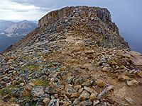 Length 1.4 miles (2.3 km) Elevation change 1180 feet (360 meters) Difficulty Easy to moderate; steep and rocky in places Rating (1-5) ★★★★★ Flat-topped summit overlooking the high point of Mirror Lake Highway, reached by a steep but popular trail over mostly treeless slopes. |
2. Big Fill Trail, Golden Spike National Historic Park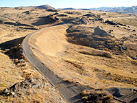 Length 1.5 miles (2.4 km); (loop) Elevation change 20 feet (6 meters) Difficulty Easy Rating (1-5) ★★★★★ This unusual trail follows short sections of two parallel railroad grades, long disused; both cross a barren, grassy hillside, past rocky outcrops, through several small cuts and over a few fills. The two rail lines were built by competing companies in the 1860s. |
3. Box Canyon Trail, Dinosaur National Monument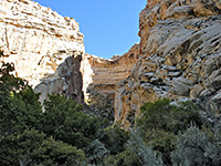 Length 0.4 miles (0.6 km) Elevation change 0 feet (0 meters) Difficulty Easy Rating (1-5) ★★★★★ Two paths begin next to Josie Morris Cabin, a historic ranch at the end of Cub Creek Road, 9.5 miles east of the visitor center; the shortest winds through the lower end of Box Canyon, a sheer walled gorge once used as a corral for pigs. The canyon is cool, shady, moist, and quite overgrown, containing patches of trees, bushes, wildflowers and long grass; the floor stays level for 0.4 miles, as far as a steep rocky slope which marks the end of the trail. |
4. Cascade Springs, Mount Timpanogos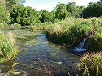 Length 0.7 miles (1.1 km); loop Elevation change 60 feet (18 meters) Difficulty Easy Rating (1-5) ★★★★★ Powerful, year-round springs creating pools, cascades and travertine formations, lined by lush vegetation and toured by a boardwalk loop trail; in the valley of Provo Deer Creek, on the east side of the Wasatch Mountains. |
5. Desert Voices Trail, Dinosaur National Monument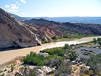 Length 1.5 miles (2.4 km); (loop) Elevation change 160 feet (49 meters) Difficulty Easy Rating (1-5) ★★★★★ The Desert Voices Trail starts along the short side road to Split Mountain campground/boat launch, beside the Green River; it follows a usually dry streambed (Cottonwood Wash), away from the river, climbing gently up to a viewpoint at the upper end of the ravine, then loops back along the south side. There are many interpretive notices along the way (produced by local children), which describe the wildlife and geology of the area, though the views are somewhat limited for much of the way and the immediate landscape is not so interesting - just bushes and sandy mounds |
6. Fossil Discovery Trail, Dinosaur National Monument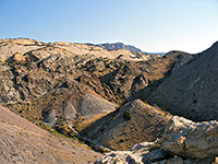 Length 1.4 miles (2.3 km); (loop) Elevation change 200 feet (61 meters) Difficulty Easy Rating (1-5) ★★★★★ Starting next to the Dinosaur National Monument visitor center, the Fossil Discovery Trail runs alongside the highway at the base of layered cliffs, passes an NPS employee residence/maintenance area then turns north, up a shallow ravine that cuts through jagged, colorful, upturned strata. A very short spur on the left leads to a viewpoint on top of one of the ridges, then soon after another path forks off on the right side towards several fossil sites - single, isolated dinosaur bones still securely embedded in the rock. |
7. Hog Canyon Trail, Dinosaur National Monument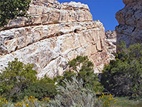 Length 0.8 miles (1.3 km) Elevation change 40 feet (12 meters) Difficulty Easy Rating (1-5) ★★★★★ Hog Canyon Trail is the longer of two easy paths leading from Josie Morris Cabin into narrow canyons at the edge of the Yampa Plateau. At first the route is quite shaded, passing trees and a small pond near the cabin; it later turns north, following a small trickling stream across an open area into the mouth of the canyon, where the cliffs close in and the surroundings become quite cool and sheltered. |
8. Lofty Lake Loop, Uinta Mountains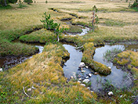 Length 4 miles (6.4 km); round trip Elevation change 900 feet (274 meters) Difficulty Easy to moderate Rating (1-5) ★★★★★ Enjoyable hike passing four lakes and a floral meadow, with a mixture of wooded and rocky surroundings. Contrasting views across different parts of the Uinta Mountains. |
9. Naturalist Basin, Uinta Mountains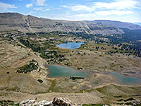 Length 14.5 miles (23.3 km); round trip to the ridge east of Mount Agassiz Elevation change 1800 feet (549 meters) Difficulty Moderate - long but not difficult Rating (1-5) ★★★★★ Beautiful, high elevation region with many lakes and meadows, surrounded by dramatic cliffs. A popular backpacking region but within range of a day hike, most of which is through thick woodland. An optional, off trail climb reaches a ridge east of Mount Agassiz, for even more spectacular views. |
10. Notch Mountain Trail, Uinta Mountains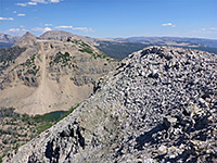 Length 6 miles (9.7 km); round trip, including the western summit Elevation change 1200 feet (366 meters) Difficulty Strenuous Rating (1-5) ★★★★★ Path through woods, past several lakes and ponds, up to the Notch, a gap between the twin peaks of an elongated mountain. An off-trail extension reaches the western summit, returning via another path that encounters even more lakes, and makes a 6 mile loop. For shorter hikes, the main destination is Wall Lake along the eastern trail, reached after one mile. |
11. Timpanogos Cave Trail, Timpanogos Cave National Monument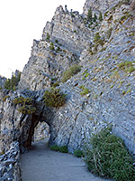 Length 1.5 miles (2.4 km) Elevation change 1100 feet (335 meters) Difficulty Moderate Rating (1-5) ★★★★★ The path to Timpanogos Cave is consistently steep from the beginning, climbing the crumbing igneous rocks of American Fork Canyon. There are various numbered points of interest along the route, mostly rocks and plants. The path offers grand views of the surrounding mountains, especially to the southwest - towards Provo and the desert beyond. The cave itself may be viewed as part of a ranger-led tour. |
12. Timpooneke Trail, Mount Timpanogos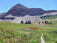 Length 6.5 miles (10.5 km) Elevation change 4380 feet (1335 meters) Difficulty Strenuous; steep, and often exposed, so quite hot in summer Rating (1-5) ★★★★★ Tiring but spectacular trail to the top of Mount Timpanogos; one of the best hikes in all Utah. The path climbs a succession of basins and steep slopes, then follows a ridge to the summit. Another branch crosses a pass to pretty Emerald Lake, then descends to an alternative start point at Aspen Grove. |
All Contents © Copyright The American Southwest | Comments and Questions | Contribute | Affiliate Marketing Disclosure | Site Map