Highlights:
Hundreds of fossilized dinosaur bones, embedded in a steep rock face near the Green River. Away from here, the vast park backcountry contains many canyons, ridges, mesas and grassy plains. Most trails are short. The main regions are Deerlodge Park, Dinosaur Quarry, Gates of Lodore and Harpers Corner
Nearby town:
Vernal, 19 miles
Management:
Location:
40.440, -109.300 (the dinosaur quarry)
Seasons:
All year
Rating (1-5):
★★★★★
Weather:


Dinosaur NM is part of the Yellowstone and North Utah itinerary
Featured Hotel
Holiday Inn Express Vernal
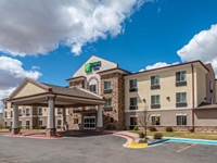 20 miles from the dinosaur quarry on the west edge of Vernal; a modern hotel with a quiet, countryside setting, offering free hot breakfast and an indoor pool
Check Rates
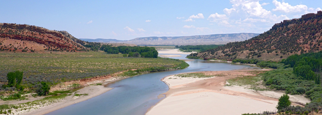
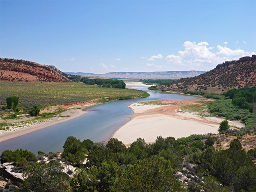
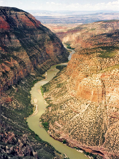
The Uinta Basin is a large depression in remote northeast Utah, encircled by several mountain ranges and bisected by the Green River - the basin extends approximately from Vernal in the north to the town of Green River in the south and is largely inaccessible by road. Habitation in this area is restricted to the Uintah/Ouray Indian Reservation, reached only by several long dirt tracks. North of the basin, the Green River crosses from Utah into Colorado and is joined by the Yampa River, and for many miles both rivers flow through deep twisting canyons and gorges cut through the sandstone mountains.
The canyons around the river junction form the centerpiece of Dinosaur National Monument, although almost all visitors come for the other main attraction - a steep cliff face, now enclosed within a large building, covered by hundreds of large fossilized dinosaur bones. This dinosaur quarry is located close to the Green River, 6 miles from US 40 near Vernal, and was reopened fall 2011 after being shut for 5 years due to subsidence. A few dinosaur bones can also be viewed in situ on a nearby trail.
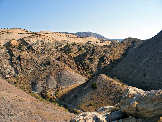
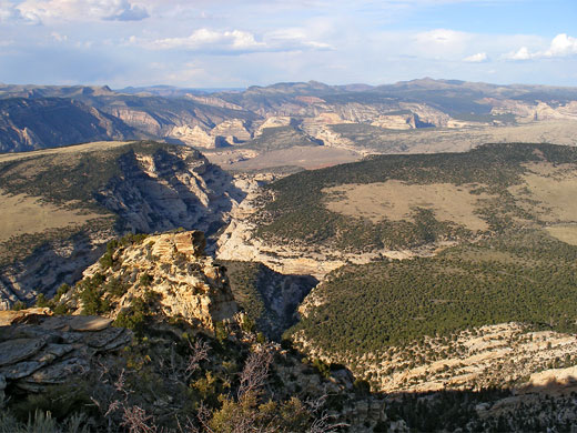
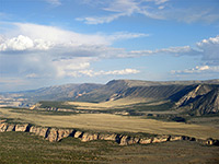
For 50 miles north and east, the land becomes mountainous, and a large area of colorful canyons and ridges is protected within the monument boundary, viewable from various overlooks, maintained paths, or extended off trail hiking; the main access route is the 30 mile Harpers Corner Road.
The canyons around the river junction form the centerpiece of Dinosaur National Monument, although almost all visitors come for the other main attraction - a steep cliff face, now enclosed within a large building, covered by hundreds of large fossilized dinosaur bones. This dinosaur quarry is located close to the Green River, 6 miles from US 40 near Vernal, and was reopened fall 2011 after being shut for 5 years due to subsidence. A few dinosaur bones can also be viewed in situ on a nearby trail.
For 50 miles north and east, the land becomes mountainous, and a large area of colorful canyons and ridges is protected within the monument boundary, viewable from various overlooks, maintained paths, or extended off trail hiking; the main access route is the 30 mile Harpers Corner Road.
Dinosaur Table of Contents
- Map of the national monument
- Photographs
- The dinosaur quarry area
- Scenic drive - Tour of the Tilted Rocks
- The canyons
- Regions of the national monument
- Hiking at Dinosaur NM
- Wildflowers of Dinosaur NM
- Nearby places
- Similar places
Location
Map of Dinosaur National Monument.
Photographs
The west, the east.
Southwest - the Dinosaur Quarry Area
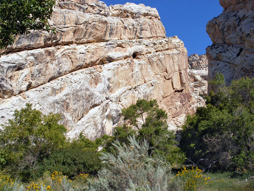
The approach to Dinosaur National Monument from the southwest is dominated by Split Mountain, a rocky sandstone ridge that really does look as if it has been recently cleaved by some great force, exposing many twisted strata. At Jensen, a turn off (country route 149) from US 40 leads across a belt of farmland into the west section of the monument, by far the most visited area. The famous quarry building is located a quarter of a mile from the entrance road at the edge of the Split Mountain foothills; this protects the source of the largest single collection of bones from the Jurassic period ever found. The July 2006 closure was a result of many years of gradual damage to the building caused by movement of the underlying soft soils. The visitor center is located downhill from the quarry along the main road; this has various exhibits, examples of native plants, a bookstore, and one fiberglass dinosaur. The Fossil Discovery Trail starts outside and leads to a number of unexcavated fossil dinosaur bones in the surrounding hills - see hiking guide. There are no other fossils on display elsewhere in the monument, and although they may possibly be found by casual prospectors, it is illegal to remover specimens, and discoveries should instead be reported to the authorities.
Scenic Drive - Tour of the Tilted Rocks
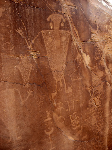
Past the visitor center turn-off, road 149 continues for ten miles, crossing the Green River, and passing two nature trails, many panels of ancient Indian petroglyphs, two campsites, a historic log cabin and two shady box canyons. The first group of petroglyphs is reached after one mile - at the base of the reddish cliffs lining the road, though most of the pictures are rather faded. Not far beyond, route 149 passes the trailhead for the Sound of Silence nature trail, and then a side road that descends to the shores of the Green River just as it emerges from Split Mountain Canyon, and leads to a picnic area, boat launch ramp and campsite, plus another trailhead, for the Desert Voices loop path. There is no trail into the canyon though walking upstream is quite easy, along beaches and sand banks on the west side of the river. The largest park campground (Green River) is a mile south, offering 88 tent or RV sites, with drinking water but no hook-ups. The main road then crosses the Green River on a slender bridge and enters private land for a few miles (Chew Ranch), passing fields and crops, before re-entering the monument where it becomes narrow and unpaved, and meets a turn-off for a rougher track to the Blue Mountain/Cliff Ridge area. The scenic drive continues a further 1.5 miles, running along the shallow canyon of Cub Creek, through red rocks bearing many more petroglyphs, most in good, crisp condition. Some are signposted but the majority are unmarked. The road ends at a clearing in a patch of woodland beside a log cabin built by pioneer Josie Morris, who lived here from 1914 to 1963. The roof is a modern replacement but most of the rest of the structure is genuine, and the site includes various other relics such as livestock enclosures, drainage ditches and corrals. Two short trails start here, to Box Canyon and Hog Canyon (see hiking guide).
East - the Canyons
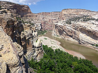
Most of the 200,000 acres of Dinosaur National Monument lie in Colorado and contain colorful ridges, plateaus and canyons surrounding the Green and Yampa rivers, which form an approximately inverted T-shape (see map). This rocky and hostile area was not part of the original monument established in 1915, but was added in 1932 once the need to protect the land was realized. The canyons are different in character to others of the Colorado river system such as Canyonlands, Glen Canyon or the Grand Canyon, with their eroded flat layers, since here many of the strata have been twisted by geological forces and the rocks are usually white and grey, not the dominant red found further south. Apart from road 149 to the dinosaur quarry and Split Mountain, there are only four other paved routes leading into the wilderness area around the rivers:
Harpers Corner Road
The road to Harpers Corner is the main access route and gives the most spectacular views of the canyon country. It starts near the town of Dinosaur on US 40 and leads north for 30 miles, ending at a high ridge far above the confluence point of the two rivers.Deerlodge Park Road
From the dinosaur quarry, the monument extends 40 miles to the east, well into Colorado, to include all the canyons formed by the Yampa River. Deerlodge Park is a flat area just within the eastern boundary, west of which the river begins to descend and soon becomes inaccessible between high sandstone cliffs as it flows towards the Green River. The Yampa is the only major river in the southwest which has not been restricted by a dam. A 12.5 mile paved road links this section of park with US 40; facilities include a seven-site campground, a ranger station and a half mile trail.Road 34
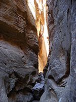
To the north, a short drive southwest off CO 318 along county road 34 reaches the Tolkienesque-sounding Gates of Lodore, where striking reddish rock formations mark the start of the Canyon of Lodore. Within here the Green River flows south over many rapids and cascades before eventually emerging near the dinosaur quarry and passing more sedately into the Uinta Basin. Again there is a campsite, and only one short nature trail - the best way to see the canyon below this point is by boat.Jones Hole Road
Starting from Vernal, the narrow Jones Hole Road leads to a national fish hatchery (open daily to the public) on Jones Creek after 40 miles across the high Diamond Mountain Plateau. Beyond, an easy foot trail follows the creek down for 4 miles until it meets the very steep-sided Whirlpool Canyon of the Green River.
Regions of Dinosaur National Monument
Easternmost section of the park; grassy flats at the mouth of the Yampa River canyon, which is viewable by a short trail. More can be seen by off-trail hiking
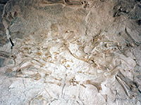
Location of the major fossil discoveries; an excavated cliff face displaying hundreds of bones, contained within a recently rebuilt, glass-walled building
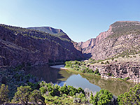
Remote, peaceful stretch of the Green River as it enters a deep, inaccessible, red-walled canyon, viewable along a short trail. Also a campground and boat launch ramp
Main road into the canyon country that makes up most of the national monument, centered on the confluence of the Green and Yampa rivers
Hiking at Dinosaur National Monument
All Dinosaur NM trails; the relatively few maintained paths in the national monument, mostly visiting overlooks and narrow canyons
Featured Hike
Buckwater Draw
★★★★★
★★★★★
3 miles, 800 feet
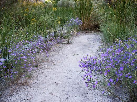
Dryfalls and short slots through attractive, light-colored sandstone, near Harpers Corner RoadDinosaur National Monument Wildflowers
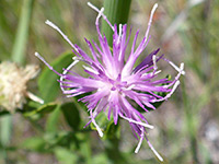
Photographs and descriptions of flowering plants found in the national monument
Dinosaur - Nearby Places
- Fantasy Canyon (40 miles) - strangely eroded sandstone layers either side of a shallow ravine, in the Uinta Basin
- Flaming Gorge National Recreational Area (58 miles) - large lake on the Green River, upstream from Dinosaur NM, with more deep canyons
- McConkie Ranch Petroglyphs (28 miles) - famous rock art site
Dinosaur - Similar Places
- Florissant Fossil Beds National Monument, Colorado - petrified sequoia logs and other fossils, in the Rocky Mountains
- Fossil Butte National Monument, Wyoming - a smaller scale fossil quarry
All Contents © Copyright The American Southwest | Comments and Questions | Contribute | Affiliate Marketing Disclosure | Site Map