Bald Mountain
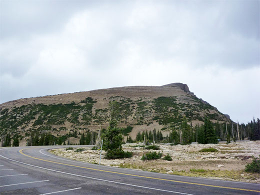
Flat-topped summit overlooking the high point of Mirror Lake Highway, reached by a steep but popular trail over mostly treeless slopes
Length: 1.4 miles
Elevation change: 1,180 feet
Difficulty: Easy to moderate; steep and rocky in places
Type: One way
Usage: Medium
Season: Summer, early fall
Trailhead: Side road near Bald Mountain Pass, along Hwy 150
Rating (1-5): ★★★★★
Elevation change: 1,180 feet
Difficulty: Easy to moderate; steep and rocky in places
Type: One way
Usage: Medium
Season: Summer, early fall
Trailhead: Side road near Bald Mountain Pass, along Hwy 150
Rating (1-5): ★★★★★

That the Bald Mountain Trail is the most popular summit hike in the Uinta Mountains is not surprising given the vast majority of peaks are miles from any road and no others have an official path to the top, but the views are still very good, comparable to many of the harder-to-reach summits, due in part to be relatively high elevation (11,943 feet).
The trail gains a modest 1,180 feet, and it has a elevated starting point at Bald Mountain Pass, the highest place along Mirror Lake Highway (UT 150); the distance to the summit is just 1.4 miles so the round-trip can be done in little more than one hour. The slopes are mostly free of trees - just a few patches of stunted pines about half way up, so the surrounding landscape is in full view all the way. The only occasional problem is lightening, from the thunderstorms that build up quite frequently on summer afternoons, but a typical fine day may see many dozen people on the trail.
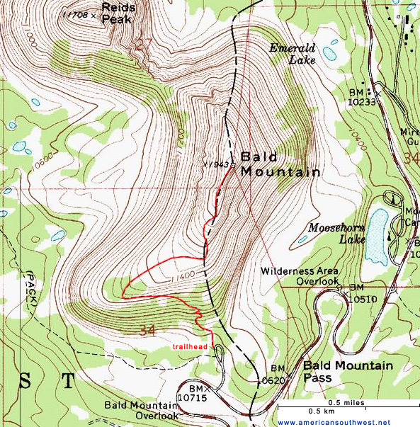
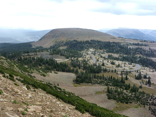
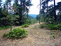
The trailhead is shared with parking for a picnic area, at the end of a little spur road on the north side of UT 150 near Bald Mountain Pass. The longer Notch Mountain Trail also starts here, heading west past several lakes and entering the upper end of Weber River Canyon, but almost all hikers are here for the shorter trek up Bald Mountain. Like all trailheads along the highway, all parked vehicles must display a pass, cost $3.
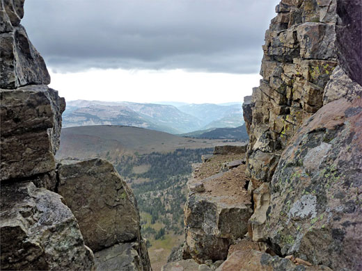
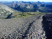
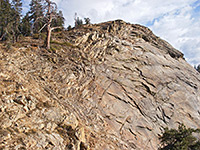
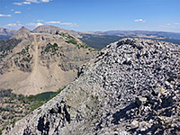
The path winds briefly through a patch of tall trees then begins the first part of the climb, up a steeply-sloping hillside via a few switchbacks, cutting across natural ledges in the rocks, which are attractively colored in shades of orange and grey. Next is a longer uphill straight, moving due west and into a grove of dwarf pines, then turning back northeast, the gradient now less steep, across a wide, stony, treeless expanse. The trail moves close to the east edge of the mountain, zig-zagging up a slanted ridgeline, initially over angular bedrock and then through big boulders and scree, as the surroundings become ever more rugged and colorful. Towards the summit the ground is split by ravines and narrow cracks, some going down 20 feet or more. The east face of the mountain is especially dramatic and jagged, dropping down near vertically in series of cliffs and vertical fractures.
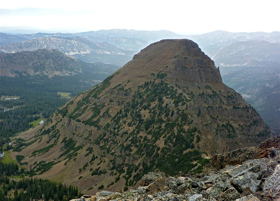
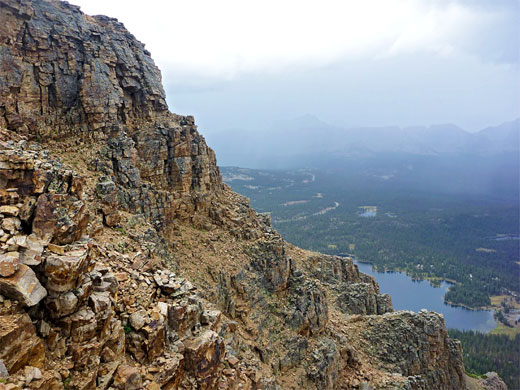
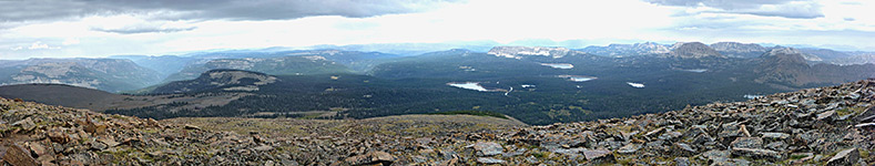
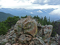
The top of Bald Mountain is fairly flat overall, with the highest point towards the far (north) side, overlooking the Mirror Lake area. The similarly shaped Reids Peak rises to the northwest, a little less tall. The panorama from the summit of Bald Mountain is unobstructed as there are no higher peaks nearby; other features in view include Moosehorn Lake directly below to the east, Murdock Mountain to the southeast, Emerald Lake to the north and Lost Lake to the southwest. The exposed slopes have a scattering of mostly small wildflowers, such as sulphurflower buckwheat, Gordon's mousetail, yarrow and moss campion. The summit rocks are naturally angular and colorful - reds, yellows and grays, and their appearance is enhanced by a mottled covering of orange and green lichen.
The trail gains a modest 1,180 feet, and it has a elevated starting point at Bald Mountain Pass, the highest place along Mirror Lake Highway (UT 150); the distance to the summit is just 1.4 miles so the round-trip can be done in little more than one hour. The slopes are mostly free of trees - just a few patches of stunted pines about half way up, so the surrounding landscape is in full view all the way. The only occasional problem is lightening, from the thunderstorms that build up quite frequently on summer afternoons, but a typical fine day may see many dozen people on the trail.
Bald Mountain Trailhead
The trailhead is shared with parking for a picnic area, at the end of a little spur road on the north side of UT 150 near Bald Mountain Pass. The longer Notch Mountain Trail also starts here, heading west past several lakes and entering the upper end of Weber River Canyon, but almost all hikers are here for the shorter trek up Bald Mountain. Like all trailheads along the highway, all parked vehicles must display a pass, cost $3.
The Trail
The path winds briefly through a patch of tall trees then begins the first part of the climb, up a steeply-sloping hillside via a few switchbacks, cutting across natural ledges in the rocks, which are attractively colored in shades of orange and grey. Next is a longer uphill straight, moving due west and into a grove of dwarf pines, then turning back northeast, the gradient now less steep, across a wide, stony, treeless expanse. The trail moves close to the east edge of the mountain, zig-zagging up a slanted ridgeline, initially over angular bedrock and then through big boulders and scree, as the surroundings become ever more rugged and colorful. Towards the summit the ground is split by ravines and narrow cracks, some going down 20 feet or more. The east face of the mountain is especially dramatic and jagged, dropping down near vertically in series of cliffs and vertical fractures.
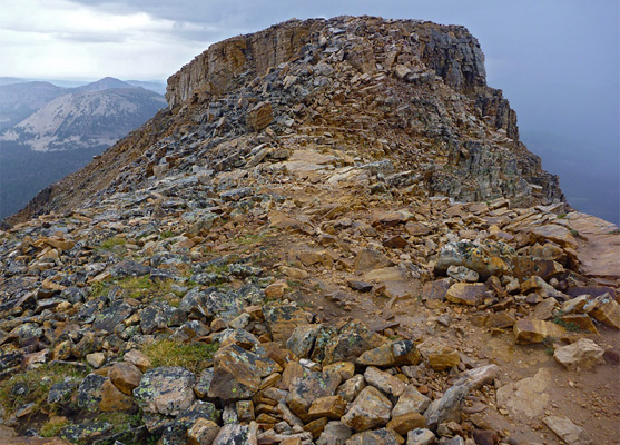
Bald Mountain Summit
The top of Bald Mountain is fairly flat overall, with the highest point towards the far (north) side, overlooking the Mirror Lake area. The similarly shaped Reids Peak rises to the northwest, a little less tall. The panorama from the summit of Bald Mountain is unobstructed as there are no higher peaks nearby; other features in view include Moosehorn Lake directly below to the east, Murdock Mountain to the southeast, Emerald Lake to the north and Lost Lake to the southwest. The exposed slopes have a scattering of mostly small wildflowers, such as sulphurflower buckwheat, Gordon's mousetail, yarrow and moss campion. The summit rocks are naturally angular and colorful - reds, yellows and grays, and their appearance is enhanced by a mottled covering of orange and green lichen.
Topo Map of Bald Mountain
Bald Mountain Trail - Similar Hikes
All Contents © Copyright The American Southwest | Comments and Questions | Contribute | Affiliate Marketing Disclosure | Site Map