Timpooneke Trail
Tiring but spectacular trail to the top of Mount Timpanogos; one of the best hikes in all Utah. The path climbs a succession of basins and steep slopes, then follows a ridge to the summit. Another branch crosses a pass to pretty Emerald Lake, then descends to an alternative start point at Aspen Grove
Length: 4.4 miles to the junction in Timpanogos Basin, then Emerald Lake 5.6 miles, or the summit 6.5 miles
Elevation change: 2,830 feet, 3,110 feet, 4,380 feet
Difficulty: Strenuous; steep, and often exposed, so quite hot in summer
Type: One way
Usage: Medium to high
Season: Late spring, summer, fall
Trailhead: Timpooneke, along a short side road, or Aspen Grove, on the Alpine Loop
Rating (1-5): ★★★★★
Elevation change: 2,830 feet, 3,110 feet, 4,380 feet
Difficulty: Strenuous; steep, and often exposed, so quite hot in summer
Type: One way
Usage: Medium to high
Season: Late spring, summer, fall
Trailhead: Timpooneke, along a short side road, or Aspen Grove, on the Alpine Loop
Rating (1-5): ★★★★★

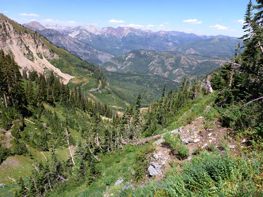
Mount Timpanogos is the second highest peak in the 160 mile long Wasatch Range - a prominent, 11,752 foot summit behind only Mount Nebo, which is 176 feet higher. The mountain dominates the skyline west of the cities of Orem, Pleasant Grove and American Fork, and can be viewed from the east via the scenic Alpine Loop Road, along which are two trailheads for paths to the summit. Both routes are long, strenuous and steep, gaining over 4,000 feet, yet the summit is a very popular destination, in part due to the proximity to major cities, and is reached by dozens of people each day during busier times of the year.
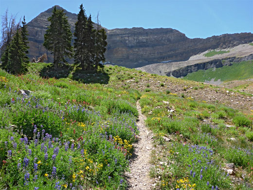
Melting snow usually allows ice-free access by late spring, and the slopes remain clear until November. The hike is one of the best in all Utah, owing to the grand views, the abundant wildflowers and the varied scenery, which includes woodland, riparian valleys, grassy basins, limestone ridges, tundra slopes and a glacial lake.
The most popular route to the summit is the Timpooneke Trail, starting along a short, paved side road to the Timpooneke Campground, at elevation 7,370 feet. This path climbs the Grand Staircase, a major canyon that gains height via a series of flat benches and steep slopes, ending at Timpanogos Basin, a sheltered, grassy bowl home to numerous wildflowers in summer, and a herd of mountain goats. Here (after 4.4 miles) the path splits, and one branch ascends further, up and along a ridge to the summit (6.5 miles), while the other crosses the basin to a junction with the Mount Timpanogos Trail, which to the east climbs over a low pass, descends past scenic Emerald Lake and continues down another big valley to the alternative trailhead at Aspen Grove, 6.5 miles further south along the Alpine Loop. In the other direction, this path reaches the summit in 1.5 miles, a total of 6.9 miles from Aspen Grove. The link path across the basin allows hikers on the Timpooneke Trail to visit both the summit and the lake, a 5 mile partial loop after the lower, one-way section.
Comparing the two routes to the summit, the Timpooneke Trail is busier, 0.4 miles shorter, generally less steep, and encounters better scenery, though does not visit the lake, while the Mount Timpanogos Trail is a little less popular, passes less varied scenery, and is steeper in some sections.
Mount Timpanogos topographic map.
29 views along the Timpooneke Trail, to Emerald Lake.
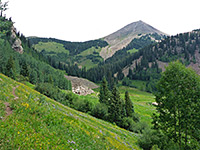
The short side road (Timpooneke Road, FR 056) is quite narrow, winding uphill through thick woods, first passing the paved, recently enlarged parking area at the trailhead, and then the shady campground. A pass is needed for all vehicles along the Alpine Loop, at a cost $6 per day (2024), paid at entrance booths at either end of the road. After the campground, the side road becomes unpaved and curves around the western slopes of the mountain for a few miles; most is for 4WD only. The trail starts beside a noticeboard, map and register, at a three-way junction, the most used path, to the peak, is the middle branch.
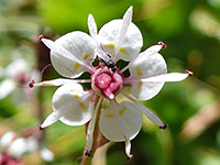
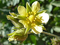
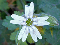
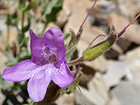
This trail ascends not too steeply, through oak and spruce woodland, moving up the west side of the wide valley. The surroundings open out for a while, giving views down to several pools along the stream that flows down the canyon, a hundred feet below, and later another treeless stretch allows the first glimpse of the peaks ahead. The gradient increases a little, as the trail enters more overgrown terrain, crossing a few tiny streams and then a larger creek, several times, as the route switchbacks up a steepening slope. A signed spur curves round a corner, beneath some larger trees to moss-lined Scout Falls, an otherwise hidden waterfall along the main watercourse through the canyon. The next section of the hike alternates between cool, wooded areas, where flowers persist all summer, and exposed, drier places where many plants have withered by the end of spring. The most abundant species in the moister patches include brook saxifrage, Columbian monkshood and seep-spring monkeyflower.
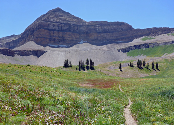
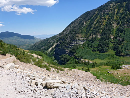
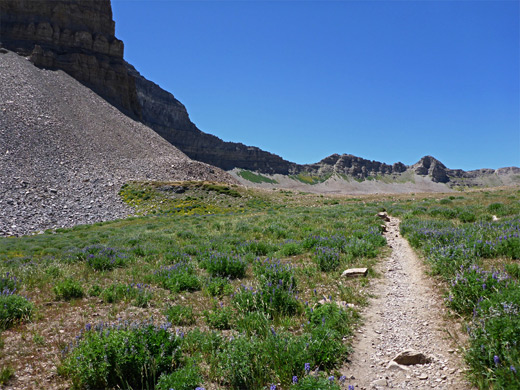
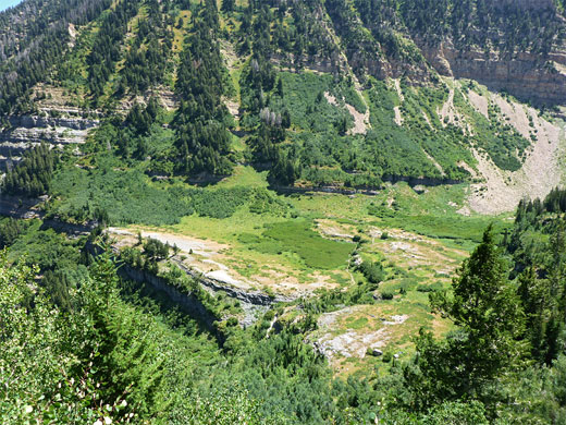
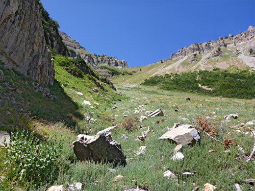
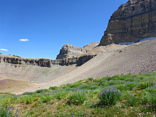
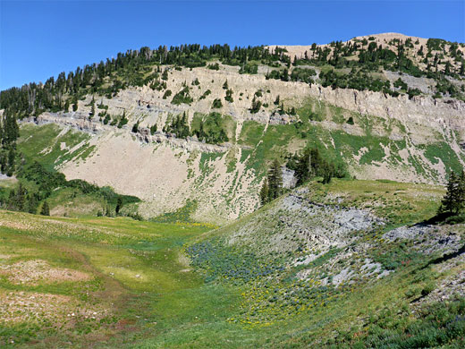
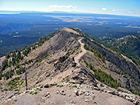
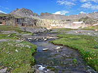
After the final stream crossing, more climbing leads to a rocky plateau and then, beyond a low ledge, to a much larger open area, the Middle Basin, its floor partly formed of flat, weathered, grey limestone. The path crosses to a shady region on the far side then runs along the base of some minor cliffs, past a few seeps. It starts climbing again over gentle, bushy or grassy slopes for the next mile, heading towards the west side of the basin and the start of a longer ascent, initially over bare talus, and then through a mix of woods, long grass and other rocky patches, sometimes straight, in other places zig-zagging. The trail moves gradually towards the east side of the valley, over several drainages and finally across another scree slope to the rim of the open expanse of Timpanogos Basin, lined by ridges on three sides, with Mount Timpanogos rising 1,500 feet above to the south.
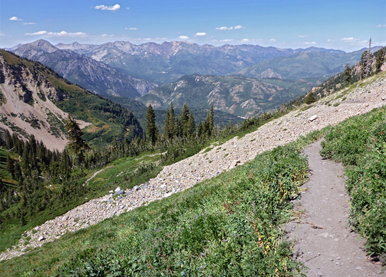
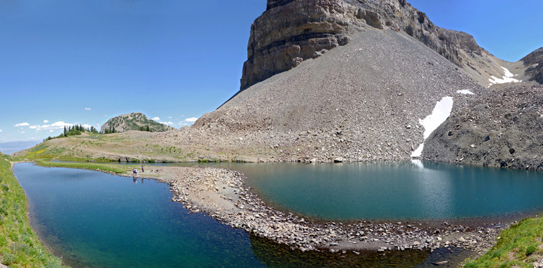
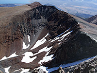
The path divides near the rim of Timpanogos Basin; right is the shortest route to the summit while left is to Emerald Lake and then the Aspen Grove trailhead. The summit path winds up a minor hill, heading west towards a dramatic ridge of exposed limestone, climbing 800 feet via several switchbacks, to the crest, where all the vast lowlands to the west are seen for the first time. From here the summit is 0.9 miles south, initially right along the ridgeline then a little way down the far side. The other route crosses Timpanogos Basin, leading to the talus-covered slopes along the south edge; it traverses the scree, across an area of bigger and sometimes loose boulders to a saddle, on a ridge extending south from 10,993 foot Roberts Horn.
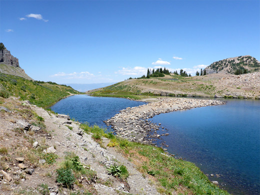
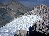
The junction with the Mount Timpanogos Trail is near the pass; this traverses back west, further up the talus slope, to an intersection with the other route, on the ridgeline. To the east, not far below, is Emerald Lake, a small but pretty feature divided by a gravel bar into two sections, with the water in the southern portion somewhat turquoise due to glacial suspension. The path descends a gentle slope, past the Emerald Lake Shelter - a hut of wood and iron construction, often staffed during the main hiking season - to the lakeshore, a popular place to rest for a while. The south side of the lake borders a steep boulder field covered with snow most of the year, sometimes used as a short-cut route when descending from the summit. Beyond the lake, the trail starts its long descent towards the eastern trailhead at Aspen Grove.
Melting snow usually allows ice-free access by late spring, and the slopes remain clear until November. The hike is one of the best in all Utah, owing to the grand views, the abundant wildflowers and the varied scenery, which includes woodland, riparian valleys, grassy basins, limestone ridges, tundra slopes and a glacial lake.
The most popular route to the summit is the Timpooneke Trail, starting along a short, paved side road to the Timpooneke Campground, at elevation 7,370 feet. This path climbs the Grand Staircase, a major canyon that gains height via a series of flat benches and steep slopes, ending at Timpanogos Basin, a sheltered, grassy bowl home to numerous wildflowers in summer, and a herd of mountain goats. Here (after 4.4 miles) the path splits, and one branch ascends further, up and along a ridge to the summit (6.5 miles), while the other crosses the basin to a junction with the Mount Timpanogos Trail, which to the east climbs over a low pass, descends past scenic Emerald Lake and continues down another big valley to the alternative trailhead at Aspen Grove, 6.5 miles further south along the Alpine Loop. In the other direction, this path reaches the summit in 1.5 miles, a total of 6.9 miles from Aspen Grove. The link path across the basin allows hikers on the Timpooneke Trail to visit both the summit and the lake, a 5 mile partial loop after the lower, one-way section.
Comparing the two routes to the summit, the Timpooneke Trail is busier, 0.4 miles shorter, generally less steep, and encounters better scenery, though does not visit the lake, while the Mount Timpanogos Trail is a little less popular, passes less varied scenery, and is steeper in some sections.
Location
Mount Timpanogos topographic map.
Photographs
29 views along the Timpooneke Trail, to Emerald Lake.

Timpooneke Trailhead
The short side road (Timpooneke Road, FR 056) is quite narrow, winding uphill through thick woods, first passing the paved, recently enlarged parking area at the trailhead, and then the shady campground. A pass is needed for all vehicles along the Alpine Loop, at a cost $6 per day (2024), paid at entrance booths at either end of the road. After the campground, the side road becomes unpaved and curves around the western slopes of the mountain for a few miles; most is for 4WD only. The trail starts beside a noticeboard, map and register, at a three-way junction, the most used path, to the peak, is the middle branch.
Start of the Trail
This trail ascends not too steeply, through oak and spruce woodland, moving up the west side of the wide valley. The surroundings open out for a while, giving views down to several pools along the stream that flows down the canyon, a hundred feet below, and later another treeless stretch allows the first glimpse of the peaks ahead. The gradient increases a little, as the trail enters more overgrown terrain, crossing a few tiny streams and then a larger creek, several times, as the route switchbacks up a steepening slope. A signed spur curves round a corner, beneath some larger trees to moss-lined Scout Falls, an otherwise hidden waterfall along the main watercourse through the canyon. The next section of the hike alternates between cool, wooded areas, where flowers persist all summer, and exposed, drier places where many plants have withered by the end of spring. The most abundant species in the moister patches include brook saxifrage, Columbian monkshood and seep-spring monkeyflower.
Middle Basin
After the final stream crossing, more climbing leads to a rocky plateau and then, beyond a low ledge, to a much larger open area, the Middle Basin, its floor partly formed of flat, weathered, grey limestone. The path crosses to a shady region on the far side then runs along the base of some minor cliffs, past a few seeps. It starts climbing again over gentle, bushy or grassy slopes for the next mile, heading towards the west side of the basin and the start of a longer ascent, initially over bare talus, and then through a mix of woods, long grass and other rocky patches, sometimes straight, in other places zig-zagging. The trail moves gradually towards the east side of the valley, over several drainages and finally across another scree slope to the rim of the open expanse of Timpanogos Basin, lined by ridges on three sides, with Mount Timpanogos rising 1,500 feet above to the south.
Timpanogos Basin
The path divides near the rim of Timpanogos Basin; right is the shortest route to the summit while left is to Emerald Lake and then the Aspen Grove trailhead. The summit path winds up a minor hill, heading west towards a dramatic ridge of exposed limestone, climbing 800 feet via several switchbacks, to the crest, where all the vast lowlands to the west are seen for the first time. From here the summit is 0.9 miles south, initially right along the ridgeline then a little way down the far side. The other route crosses Timpanogos Basin, leading to the talus-covered slopes along the south edge; it traverses the scree, across an area of bigger and sometimes loose boulders to a saddle, on a ridge extending south from 10,993 foot Roberts Horn.
Emerald Lake
The junction with the Mount Timpanogos Trail is near the pass; this traverses back west, further up the talus slope, to an intersection with the other route, on the ridgeline. To the east, not far below, is Emerald Lake, a small but pretty feature divided by a gravel bar into two sections, with the water in the southern portion somewhat turquoise due to glacial suspension. The path descends a gentle slope, past the Emerald Lake Shelter - a hut of wood and iron construction, often staffed during the main hiking season - to the lakeshore, a popular place to rest for a while. The south side of the lake borders a steep boulder field covered with snow most of the year, sometimes used as a short-cut route when descending from the summit. Beyond the lake, the trail starts its long descent towards the eastern trailhead at Aspen Grove.
Mt Timpanogos Wildflowers
More flowers along the trail
 Brook saxifrage |
 Sierran woodbeauty |
 Douglas' catchfly |
 Cord-root beardtongue |
More flowers along the trail
Timpooneke Trail - Similar Hikes
All Contents © Copyright The American Southwest | Comments and Questions | Contribute | Affiliate Marketing Disclosure | Site Map