Alpine Loop
Narrow, winding scenic drive through the Timpanogos Mountains and the Uinta-Wasatch-Cache National Forest, passing viewpoints, trailheads and campgrounds
Length: 27 miles, from Alpine to Orem

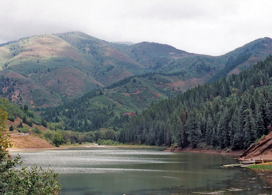
The northern approach road to the Alpine Loop, UT 92, is a long straight city street that climbs gently towards the entrance of American Fork Canyon then once inside becomes quite narrow and treelined with the rocky canyon walls rising steeply for over a vertical mile above. The road follows a fast flowing creek and passes several basic campsites, and the visitor center of Timpanogos Cave National Monument. After 5 miles, the main route leaves the creek and turns southeast, climbing deep into the mountains while a side road continues a little further beside the stream, to South Lake Flat Reservoir where many tracks radiate out into the surrounding hills - this is one of the main ATV areas.
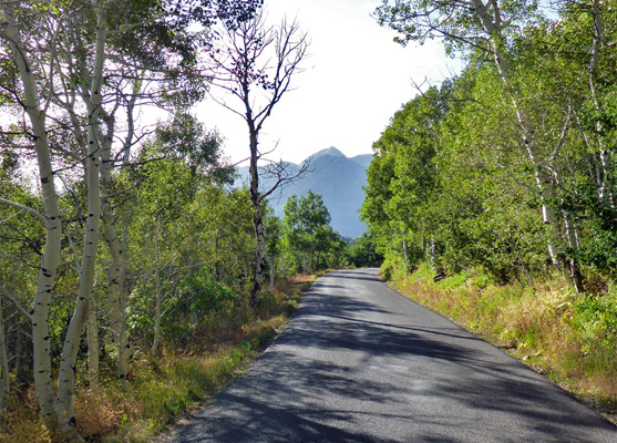
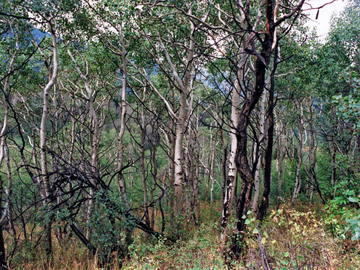
After the junction UT 92 passes through a beautiful Alpine landscape with many vistas of rocky peaks and canyons, and large expanses of dense woodland - mostly gleaming white aspen. The recently resurfaced road is very narrow and curving, with dozens of 10 mph bends and reaches a high point of 7,900 feet, high enough for snowfall to close parts of the road from November through May. Near this summit, another slightly less winding side road descends quite steeply through the forest to Cascade Springs, and links with other back-country routes.
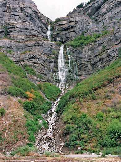
After an even more twisting downhill section, the road reaches other fee station for the Alpine Loop near the village of Aspen Grove, a major skiing center in winter, and the location of the trailheads for the two 7 mile paths to the top of 11,750 foot Mount Timpanogos. The mountains and neighbouring peaks are protected as the Mount Timpanogos Wilderness, a stark and beautiful region mostly above the treeline with several small lakes and a permanent snowfield. The road from here to the junction with US 189 through Heber Valley/Provo Canyon is straighter and busier; en route it passes the turning to Sundance, a ski resort/village/arts centre owned by actor Robert Redford. US 189 passes beneath several waterfalls, most spectacular being the 607 foot Bridal Veil Falls; this has a 2-stage drop down the side of the canyon, and is easily reached by a side road. Close by is an aerial tramway, supposedly one of the world's steepest, which is only open during summer.
Landscape
After the junction UT 92 passes through a beautiful Alpine landscape with many vistas of rocky peaks and canyons, and large expanses of dense woodland - mostly gleaming white aspen. The recently resurfaced road is very narrow and curving, with dozens of 10 mph bends and reaches a high point of 7,900 feet, high enough for snowfall to close parts of the road from November through May. Near this summit, another slightly less winding side road descends quite steeply through the forest to Cascade Springs, and links with other back-country routes.
Mount Timpanogos
After an even more twisting downhill section, the road reaches other fee station for the Alpine Loop near the village of Aspen Grove, a major skiing center in winter, and the location of the trailheads for the two 7 mile paths to the top of 11,750 foot Mount Timpanogos. The mountains and neighbouring peaks are protected as the Mount Timpanogos Wilderness, a stark and beautiful region mostly above the treeline with several small lakes and a permanent snowfield. The road from here to the junction with US 189 through Heber Valley/Provo Canyon is straighter and busier; en route it passes the turning to Sundance, a ski resort/village/arts centre owned by actor Robert Redford. US 189 passes beneath several waterfalls, most spectacular being the 607 foot Bridal Veil Falls; this has a 2-stage drop down the side of the canyon, and is easily reached by a side road. Close by is an aerial tramway, supposedly one of the world's steepest, which is only open during summer.
All Contents © Copyright The American Southwest | Comments and Questions | Contribute | Affiliate Marketing Disclosure | Site Map