Highlights:
Scenic section of the Wasatch Mountains, centered on 11,749 foot Mount Timpanogos. A narrow road (Alpine Loop) crosses part of the range, giving access to many trailheads, overlooks, campsites and forest tracks
Nearby town:
Management:
USFS - part of Uinta National Forest
Location:
40.402, -111.596 (Alpine Loop)
Seasons:
Spring, summer, fall - winter brings heavy snowfall
Rating (1-5):
★★★★★

Featured Hotel
Holiday Inn Express American Fork
 Along I-15 in American Fork, close to several restaurants, and a short drive from the Alpine Loop. Free hot breakfast and an indoor pool
Check Rates
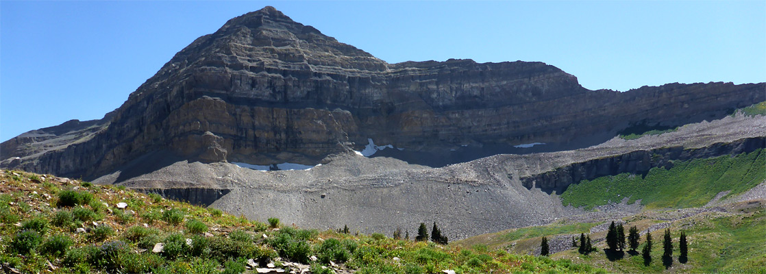
The Wasatch Range runs north-south for over 130 miles and provides an impressive backdrop for the main populated area in Utah; from Ogden through Salt Lake City to Provo and beyond, the mountains rise very steeply from the flat desert plains, with several peaks over 11,000 feet.
One of the most interesting regions is just northeast of Orem, centered on Mount Timpanogos, the second highest summit in the range; attractions in the vicinity include Timpanogos Cave National Monument, several spectacular canyons linked by a narrow, winding scenic drive (the Alpine Loop), interesting natural features like Cascade Springs and Bridal Veil Falls, and numerous opportunities for hiking, camping, climbing, fishing & ATV use.
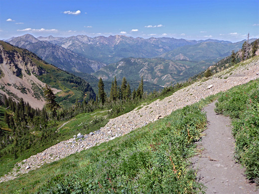
The peak itself can be climbed via two paths, both strenuous though relatively popular; from the north via the 6.5 mile Timpooneke Trail, and from the east by the Mount Timpanogos Trail, which is slightly longer and steeper.
One of the most interesting regions is just northeast of Orem, centered on Mount Timpanogos, the second highest summit in the range; attractions in the vicinity include Timpanogos Cave National Monument, several spectacular canyons linked by a narrow, winding scenic drive (the Alpine Loop), interesting natural features like Cascade Springs and Bridal Veil Falls, and numerous opportunities for hiking, camping, climbing, fishing & ATV use.
The peak itself can be climbed via two paths, both strenuous though relatively popular; from the north via the 6.5 mile Timpooneke Trail, and from the east by the Mount Timpanogos Trail, which is slightly longer and steeper.
Mount Timpanogos Table of Contents
- Map of the Mount Timpanogos Region
- Photographs
- Roads around Mount Timpanogos
- Locations; Alpine Loop, Cascade Springs, Timpanogos Cave
- Featured hike; Timpooneke Trail
- Nearby places
- Similar places
Map of the Mount Timpanogos Region
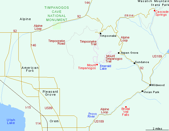
Mount Timpanogos Roads
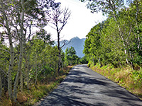
Mount Timpanogos is separated from adjacent peaks in the Wasatch Range by two deep, west-aligned canyons; American Fork and Provo, both emerging from the hills next to the correspondingly named towns. State highway 92 (known as 11000 North Street in the urban area) follows the northernmost of these, besides American Fork Creek for several miles then heads south, round the far side of the mountains through the Uinta National Forest to the Provo River where it joins US 189 between Provo and Heber City. There are two paved side roads heading further west, plus a network of unpaved tracks, ATV routes and hiking trails. An entrance charge was introduced for the Alpine Loop in 2000, and the 2020 fee is $6 per vehicle, good for three days.
Mount Timpanogos - Locations
Alpine Loop
Narrow, winding scenic drive through the Timpanogos Mountains, passing viewpoints, trailheads and campgrounds
Narrow, winding scenic drive through the Timpanogos Mountains, passing viewpoints, trailheads and campgrounds
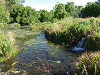
Cascade Springs
Pretty series of springs and travertine pools on the east side of the mountains, toured by an easy loop trail; in the valley of Provo Deer Creek, east of the mountains
Pretty series of springs and travertine pools on the east side of the mountains, toured by an easy loop trail; in the valley of Provo Deer Creek, east of the mountains
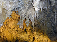
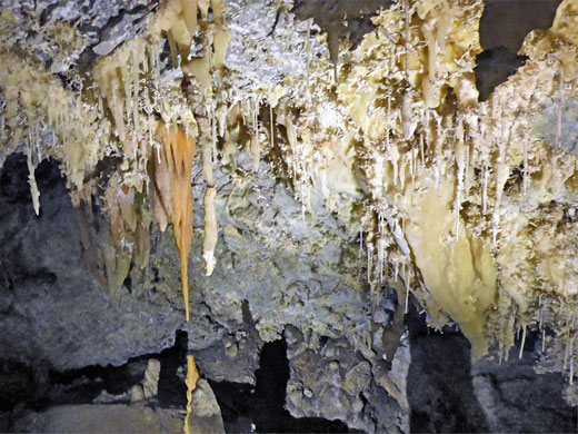
Timpanogos Cave National Monument
The most popular attraction in the area; several linked caverns high up the south side of American Fork Canyon
The most popular attraction in the area; several linked caverns high up the south side of American Fork Canyon
Mount Timpanogos - Hiking
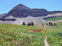
Timpooneke Trail
★★★★★
★★★★★
7 miles, 4,500 feet
Strenuous but spectacular trail to the summit of Mount Timpanogos; one of the top hikes in all UtahMount Timpanogos - Nearby Places
- Little Sahara Recreation Area (75 miles) - photogenic dunes of light-colored sand
- Wasatch Mountain State Park (20 miles) - most popular state park in Utah, on the east side of the Wasatch Range
Mount Timpanogos - Similar Places
- Nebo Loop Scenic Byway - winding road through the southern Wasatch Range
All Contents © Copyright The American Southwest | Comments and Questions | Contribute | Affiliate Marketing Disclosure | Site Map