Highlights:
Wooded hillsides, meadows, canyons and the shores of a reservoir, on the east side of the Wasatch Range. A developed park, very popular, for golf, hiking, camping and mountain biking, plus skiing in winter
Nearby town:
Heber City, 5 miles
Management:
Location:
40.533, -111.490 (visitor center)
Seasons:
All year; major center for snow-based recreation in winter
Rating (1-5):
★★★★★
Weather:


Wasatch Mountain SP is part of the Yellowstone and North Utah itinerary
Featured Hotel
Best Western Plus Heber Valley Hotel
 Well-equipped, mid range hotel with a central location in Heber City, on the east side of the US 40-US 189 intersection. Hot breakfast is complimentary
Check Rates
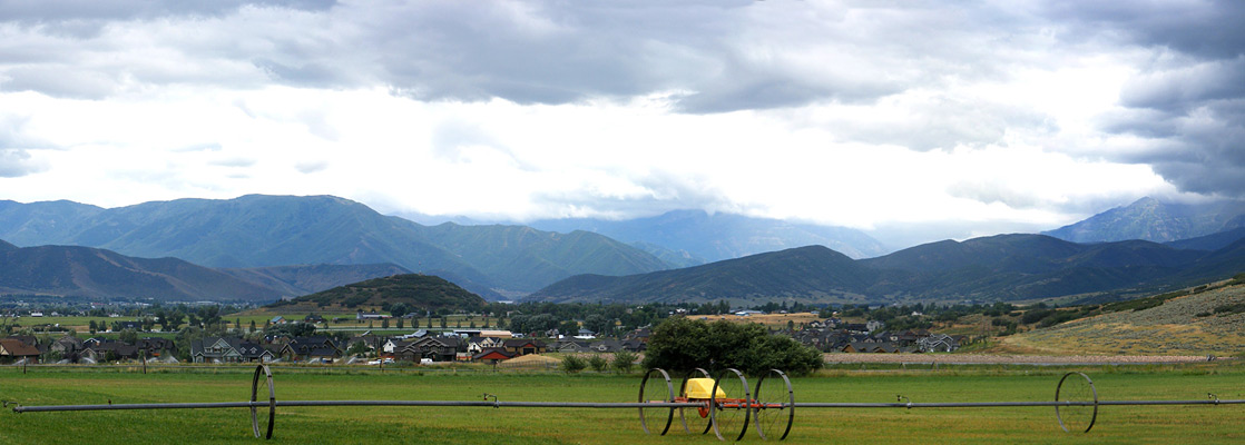
Wasatch Mountain is one of the most popular state parks in Utah, receiving 285,000 visitors in 2015, here for a wide range of recreation including golf, fishing, ATV riding, camping, hiking and horse riding, plus skiing and snowmobiling in winter, all surrounded by pleasant mountain scenery - the park lies on the east side of the Wasatch Range, centered on the small town of Midway, near Heber City.
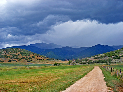
Most of the 23,000 acre preserve is wooded hillsides and canyons, snow-covered in winter and very colorful as the leaves change during fall, though not particularly spectacular overall, and not greatly different to any other part of the Wasatch foothills, which stretch for 150 miles north and south. There is no entrance station, and no fee is needed to drive through or for parking and hiking, only for certain activities like camping ($20 to $25 per night) and golf. The main approaches are from Heber City along US 40, UT 190/224 from Salt Lake City (a partly unpaved route) or US 189 from Orem.
Most of the 23,000 acre preserve is wooded hillsides and canyons, snow-covered in winter and very colorful as the leaves change during fall, though not particularly spectacular overall, and not greatly different to any other part of the Wasatch foothills, which stretch for 150 miles north and south. There is no entrance station, and no fee is needed to drive through or for parking and hiking, only for certain activities like camping ($20 to $25 per night) and golf. The main approaches are from Heber City along US 40, UT 190/224 from Salt Lake City (a partly unpaved route) or US 189 from Orem.
Wasatch Mountain Table of Contents
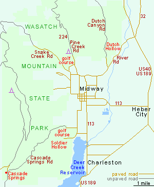
Map of Wasatch Mountain State Park
Wasatch Mountain Tours
The State Park
Approaching from the north (along River Road from US 40/189), the first section of the state park is Dutch Hollow, the main hiking area. A short side road leads to a trailhead for a network of intersecting loop paths, totalling 19 miles, over nice-looking but generally unchallenging hills, rounded in shape and covered by bushes. All routes are suitable for hiking or mountain biking, and a few are open to horses. The park headquarters and visitor center are 2 miles further west, next to the 36-hole Wasatch Mountain Golf Course, and close to various other attractions including Pine Creek Campground (136 sites, with hookups), a historic apple orchard and pioneer settlement at Huber Grove, an OHV trailhead and two nature paths. Two roads head northwards up into the hills; both soon become unpaved but are generally ok for all vehicles in dry weather. One (Pine Creek Road; UT 224) crosses a ridge and reaches Park City after 13 miles, while the other climbs up Snake Creek Canyon then turns south, over undulating, wooded hillsides then along the crest of a narrow ridge above Little Deer Creek Canyon (site of another, primitive, campground) and eventually meeting a paved road from Cascade Springs in the Mount Timpanogos region, a route which continues (now unpaved) down the hills on the south side of the state park. Also in this area is a second 36-hole golf course (Soldier Hollow), next to a winter tubing and cross-country skiing center, and the large Deer Creek Reservoir, which lies just outside the park boundary. Both the park's golf courses have restaurants, open to all visitors.
Wasatch Mountain - Nearby Places
- Timpanogos Cave National Monument (30 miles) - small cave system in American Fork Canyon
- Uinta Mountains - extensive range with much rocky terrain above the treeline
Wasatch Mountain - Similar Places
- Nebo Loop Scenic Byway - varied Wasatch Mountain scenery south of Payson

All Contents © Copyright The American Southwest | Comments and Questions | Contribute | Affiliate Marketing Disclosure | Site Map