State Parks in Utah
Other Utah listings: national parks and monuments and national forests.
Map of State Parks in Utah
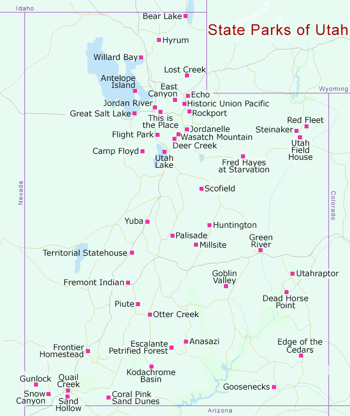
This small state park contains a museum and Ancestral Pueblo archaeological site, located in the small town of Boulder, 22 miles north of Escalante on UT 22. The excavated ruins include nearly 100 rooms and 10 pit houses, while other structures, overgrown and as yet unexplored, can be seen close by. The park also has a replica pueblo building, next to the museum, which has displays of pottery, arrowheads and other artefacts. Description |
|
Antelope is a large island on the Great Salt Lake, inhabited by a 600 strong herd of American bison, and reachable by road except at occasional times of high water when the six mile causeway may be flooded. The barren, treeless mountains in the center of the island rise over 2,000 feet above the lake, and the whole place has a stark beauty, lined by white sand flats and surrounded by reflective blue water. Description | Photographs |
|
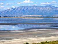
Popular park occupying several sites along the shore of Bear Lake, filled with turquoise-blue water and surrounded by barren mountains spanning the Utah-Idaho border; activities include camping, fishing, swimming, scuba diving and sailing. Description and Map |
|
| Camp Floyd Stagecoach State Park and Museum Cemetery and commissary building from Camp Floyd, a military complex near Fairfield intended as a base from which to suppress an expected Mormon rebellion. Most of the site was demolished in 1861. |
|
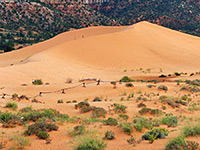
Ten miles west of Kanab, a large group of orange, crescent-shaped sand dunes has formed in a depression beneath the Moquith Mountains, and part is protected as the Coral Pink Sand Dunes State Park. The sands are open both to hikers and off road vehicles, and present an impressive scene - shapely, delicately colored dunes without any covering vegetation, backed by tall, layered cliffs to the east. Camping is available either for a fee in the park, or free of charge on the surrounding BLM land. Description |
|
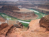
Just north of the much larger Canyonlands National Park in southeast Utah, Dead Horse Point State Park offers similar red rock scenery, containing a narrow promontory that overlooks an area of eroded cliffs and canyons enclosing the Colorado River, 30 miles from Moab. Facilities comprise a visitor center, picnic area and a well-equipped 21 site campground, plus several short trails along the edge of the promontory. Description | Panorama |
|
| Deer Creek State Park Reservoir on Deer Creek in the Wasatch Mountains - popular for the usual water-based recreation. |
|
| East Canyon State Park Medium-sized lake in a mountain canyon, 45 miles northeast of Salt Lake City adjacent to interstate 80. |
|
| Echo State Park Part of the shoreline of Echo Reservoir, near Coalville, in the Uinta Mountains of the northeast. |
|
| Edge of the Cedars State Park Museum Ruins of a ancient pueblo, and a museum with an extensive collection of Indian pottery and other artefacts. Located at the edge of Blanding, a few blocks west of US 191. |
|
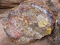
A reservoir (good for fishing), Fremont Indian relics and numerous pieces of petrified wood are the attractions of Escalante State Park, located next to the town of Escalante just off UT 12. The park has two trails through the petrified area, which contains colorful logs up to 15 feet long and 4 feet wide - not as impressive as the much more extensive deposits at Petrified Forest NP in Arizona, but still well worth the hike. Description |
|
| Flight Park State Recreation Area Mesa north of Lehi, close to interstate 15 - used as a base for hang gliding and paragliding. |
|
| Fred Hayes State Park at Starvation Fishing, boating, hiking, camping and ORV use, on and around Starvation Reservoir, in the southern foothills of the Unita Mountains. Starvation is a large, branched lake west of Duchesne, crossed by US 40. |
|
| Fremont Indian State Park and Museum Museum preserving Fremont Indian relics, from a pueblo site discovered during construction of I-70 in 1983. Park is surrounded by the Fishlake National Forest, 20 miles southwest of Richfield. |
|
| Frontier Homestead State Park Museum. Formerly known as Iron Mission State Park, this museum in Cedar City has a collection of wagons, farming equipment and many other items relating to the history of Iron County in the mid 19th century. |
|
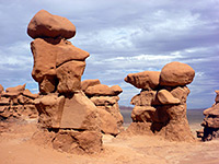
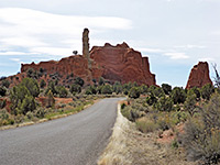
The eroded rock formations at Goblin Valley State Park are just as unusual and photogenic as those at the famous national parks further south, just on a smaller scale, and the park receives relatively few visitors. Access is via a paved road forking off UT 24, 12 miles north of Hanksville. The surrounding land has much else of interest to explore, including many narrow canyons cutting through the San Rafael Swell, an area of exposed, tilted strata. Description and Map | Photographs | Panorama - hoodoos | Panorama - cliffs |
|
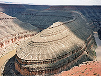
Some of the best examples of entrenched river meanders anywhere in the world can be seen in Goosenecks State Park, southeast Utah, where the San Juan River flows through a series of tight S-bends, several hundred feet below the surrounding flat lands. The park is reached by a short side road from Mexican Hat and has no facilities apart from an overlook (where camping is allowed), but the formations are well worth a visit. Description | Photographs |
|
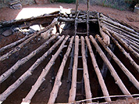
| Great Salt Lake State Park Marina and beach on the shore of the Great Salt Lake, 16 miles west of Salt Lake City via I-80. |
|
| Green River State Park Picnic area, golf course, campground and footpaths on the west bank of the Green River, just south of the namesake town, along interstate 70. |
|
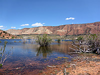
Small reservoir lined by sandy hills and red rock formations, along the Santa Clara River in the Red Mountains west of St George - offers fishing, camping and boating, plus hiking along short trails, including through a shallow slot canyon. Description and Map | Photographs |
|
| Historic Union Pacific Rail Trail Hike, ski, cycle and horse trail following course of an old railroad for 28 miles, between Park City and Echo Reservoir. |
|
| Huntington State Park Small reservoir bordered by rolling hills - just north of Huntington in Castle Valley, central Utah. |
|
| Hyrum State Park Reservoir surrounded by farmland on the south side of Hyrum, in Cache Valley, 25 miles from the border with Idaho. |
|
| Jordan River Off-Highway Vehicle State Park Venue for various kinds of motorized sports - in a residential area of Jordan next to the river, reached by I-15 or I-215. |
|
| Jordanelle State Park Sizeable lake formed by a dam across the Provo River, in a mountainous setting north of Heber City. Popular for camping, boating, fishing and swimming. |
|
Kodachrome Basin is a small state park a few miles south of UT 12 near Bryce Canyon; it contains pinnacles, arches and other eroded rock formations in various shades of red, yellow, pink, white and brown; together with the (usually) deep blue sky and occasional green vegetation this combination led the National Geographical Society to name the area, with the consent of the Kodak Film Corp. The park has a campground and several short trails. Description | Photographs | Panorama |
|
| Lost Creek State Park Centered on Lost Creek Reservoir in the eastern foothills of the Wasatch Range, offering camping, hiking and boating. Designated 2021, and still being developed. |
|
| Millsite State Park Reservoir next to a golf course with views of the nearby Wasatch Plateau. Located a few miles west of Ferron, at the edge of Castle Valley. |
|
| Otter Creek State Park Long, narrow reservoir beneath the east edge of the Sevier Plateau in central Utah, near Antimony. Boating, camping, bird watching and ORV riding are the main leisure activities. |
|
| Palisade State Park Small, lake-based park just off US 89 on the west side of the Wasatch Plateau, near Gunnison - offers swimming, camping, golf and ORV riding. |
|
| Piute State Park Artificial lake with scenic, undeveloped surroundings along the Sevier River; facilities limited to fishing and primitive camping. Reached by US 89. |
|
| Quail Creek State Park Fishing and boating on a warm-water reservoir with desert surroundings northeast of St George. Also has a campground. |
|
| Red Fleet State Park Small reservoir with the usual fishing and boating, plus a 1.25 mile trail to a set of dinosaur tracks. Park is ten miles north of Vernal, near Dinosaur National Monument. |
|
| Rockport State Park Lake along the Weber River in far north Utah, enclosed by rather barren hills; camping, fishing and boating are available. |
|
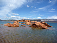
Sand Hollow State Park is based around a reservoir east of St George, lined by photogenic red rock formations and wide sandy beaches. Sand Mountain, just south of the lake, has 15,000 acres of reddish dunes, open for OHV use. The other main activies are boating, fishing, swimming and camping, either in a developed site or primitive locations along the south and east edges. Description | Photographs |
|
| Scofield State Park 2,815 acre reservoir in the mountains of the Manti-La Sal National Forest, open for ice fishing, skiing and snowmobiling in winter, or camping, hiking and boating at other times. |
|
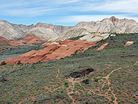
Tucked away in the low hills northwest of St George, Snow Canyon State Park features rocks of three contrasting colors - red and white Navajo sandstone, and black lava, together with other interesting volcanic relics like cinder cones and lava caves. One paved road runs through the park, passing trailheads for paths to the caves, viewpoints, side canyons, arches and other eroded rock formations. Description | Trails | Photographs | Panorama |
|
| Steinaker State Park Reservoir surrounded by low, grassy hills alongside US 191 just north of Vernal, in Utah's Dinosaurland. |
|
| Territorial Statehouse State Park Museum Museum in the statehouse at Fillmore - the oldest surviving governmental building in the state. Plus several other historical buildings. |
|
| This is the Place Heritage Park Reconstruction of a 19th century Mormon pioneer village, together with historical re-enactments and craft demonstrations. Located in northeast Salt Lake City, along Sunnyside Avenue. |
|
| Utah Field House of Natural History State Park Museum Museum in Vernal, offering many exhibits about the geology and palaeontology of northeast Utah, known as Dinosaurland. Also has a garden containing 17 full size dinosaur models. |
|
| Utah Lake State Park Marina and campground occupying a small section of the east shore of the largest freshwater lake in Utah. Reached by a 2.7 mile drive from interstate 15, near Provo. |
|
| Utahraptor State Park Open 2025, 15 miles northwest of Moab, preserving one of the largest dinosaur bone beds in the country. |
|
Utah's most popular state park, containing forested hills and valleys above Midway near Heber City, with campgrounds, golf courses and hike/bike trails. Wasatch Mountain is a center for many kinds of recreation, including during winter, when skiing, snowboarding and tubing are available. The park is quite developed but does have an unpaved scenic drive, climbing quite high into the mountains and linking with other routes into the adjacent national forest land. Description and photographs |
|
| Willard Bay State Park Wildlife watching and water-based recreation are the two main activities at Willard Bay State Park, on the northeast floodplain of the Great Salt Lake, just off interstate 15. |
|
| Yuba State Park Yuba State Park comprises two sections of the shoreline of Sevier Bridge Reservoir, and has a selection of beaches, campgrounds and boat launch points. Access is from interstate 15, 25 miles south of Nephi. |
All Contents © Copyright The American Southwest | Comments and Questions | Contribute | Affiliate Marketing Disclosure | Site Map