Highlights:
Red, yellow, pink, white and brown-colored eroded rock formations, most unusual being the tall white columns (sand pipes) rising high above the softer surrounding rocks. Park has a pleasant campground and several short, scenic trails
Nearby town:
Bryce Canyon, 19 miles
Management:
Location:
Seasons:
All year
Rating (1-5):
★★★★★
Weather:


Kodachrome Basin SP is part of the Grand Circle itinerary
Featured Hotel
Best Western Bryce Canyon
 The newest of two Best Western hotels at Bryce Canyon, offering full service facilities including an all-day restaurant. Kodachrome Basin is 20 miles southeast
Check Rates
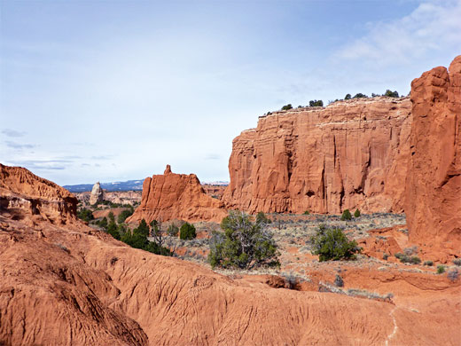
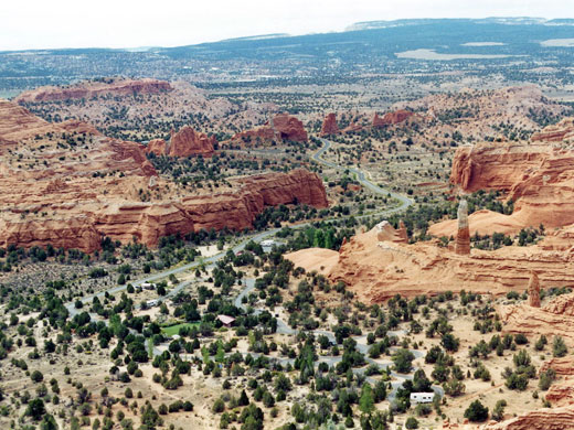
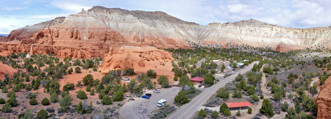
Kodachrome Basin is a small, popular state park a few miles south of UT 12 due east of Bryce Canyon, and reached by a paved road, from Cannonville. The basin contains eroded, multicolored rock formations in various shades of red, yellow, pink, white and brown; together with the (usually) deep blue sky and occasional green vegetation this combination led the National Geographical Society to name the area, in 1949, with the permission of Kodak Film Corporation.
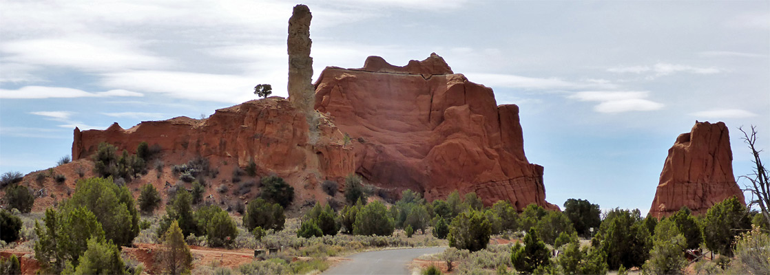
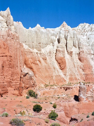
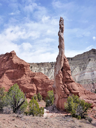
The one unique feature of the park is the presence of over 60 spires or chimneys of rock, known as sand pipes, which are thought to be solidified sediment that filled ancient springs or geysers, left standing after the softer surrounding Entrada sandstone weathered away. The tallest is 170 feet high. The Entrada layer makes up most of the red rocks in the park, while the overlying whitish strata are from the Dakota and Tropic Shale formations.
The one unique feature of the park is the presence of over 60 spires or chimneys of rock, known as sand pipes, which are thought to be solidified sediment that filled ancient springs or geysers, left standing after the softer surrounding Entrada sandstone weathered away. The tallest is 170 feet high. The Entrada layer makes up most of the red rocks in the park, while the overlying whitish strata are from the Dakota and Tropic Shale formations.
Kodachrome Basin Table of Contents
- Map of the state park
- Photographs
- Kodachrome activities and facilities
- Surroundings
- Hiking in Kodachrome Basin; 3 trails
- Nearby places
- Similar places
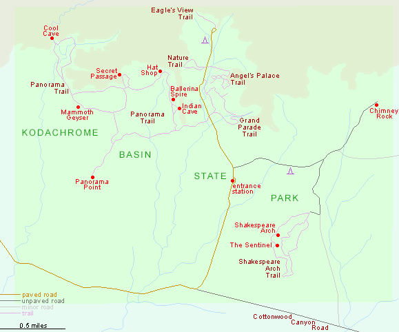
Map of Kodachrome Basin State Park
Photographs
All Kodachrome photographs.
Kodachrome Activities and Facilities
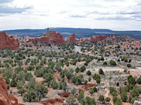
The main activities in the state park are camping and hiking, and all trails and features can be explored in one day, or at most two. The easiest place to see the sand pipes and other formations is the Grand Parade area on the east side of the park road, and two short footpaths wind through the nearby rocks, both 1.5 miles (round trip) and not too steep - the Grand Parade Trail and the Angel's Palace Trail. The road ends at a 31 site campground, where facilities include rest rooms, firepits and hot showers. Free primitive camping is available along side tracks off Cottonwood Canyon Road, a few miles southeast. The short (quarter of a mile) but rather steep and narrow Eagles View Trail begins near the park campground, climbing 460 feet to a pass at the top of the cliffs encircling the basin, and linking with another route, outside the park boundaries, that descends a valley towards Henrieville. The Eagle's View Trail offers the best overall views of the park, but because of erosion it has been closed since 2010. The longest hiking route is the Panorama Trail, a 6 mile loop past more sand pipes, an elevated viewpoint, several narrow ravines and other formations. A cut-off path allows for a shorter, 3.8 mile loop. Also starting at the campground, the half mile (loop) Nature Trail is accompanied by notices about the common plants of this arid, semi-desert region. An unpaved road forks east from near the ranger residence, past a smaller, more primitive campground to a junction; the north branch leads to Chimney Rock, the largest sand pipe in the park, while the other heads south towards (the remains of) Shakespeare Arch, reachable by a quarter mile trail that continues around a series of cliffs to make a 1.4 mile loop.
Surroundings
The surrounding country is also worth exploring, for example to see Grosvenor Arch, one of the largest of such structures in the state, which is located 10 miles southeast. Dirt tracks lead from the near the park into a large wilderness area, at the south edge of which is Lake Powell. Many colorful canyons, mesas and arches can be explored by 4WD vehicle and hiking trails; particularly notable areas are Cottonwood Canyon and the Paria River and its tributaries. All this region falls within the boundaries of Grand Staircase - Escalante National Monument.
Trails of Kodachrome Basin
Angel's Palace Trail
★★★★★
★★★★★
1.5 miles, 120 feet (loop)
Easy route that climbs a short ravine and loops around the mesatop on the east side of the park road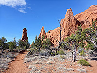
Panorama Trail
★★★★★
★★★★★
6 miles, 150 feet (loop)
The park's longest and best trail, passing a good variety of viewpoints and geological features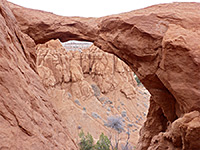
Shakespeare Arch Trail
★★★★★
★★★★★
1.4 miles, 170 feet (loop)
Loop around an isolated mesa, past a tall sand pipe and what was the only arch in the park, until it collapsed May 2019Kodachrome Basin - Nearby Places
- Bryce Canyon National Park (10 miles) - beautiful, heavily eroded cliff face with thousands of delicate hoodoos
- Willis Creek (20 miles) - short slot canyon containing a permanent stream
Kodachrome Basin - Similar Places
- Smoky Mountain Road, Glen Canyon - a scenic unpaved track that passes through the same rock layers that occur at Kodachrome Basin
All Contents © Copyright The American Southwest | Comments and Questions | Contribute | Affiliate Marketing Disclosure | Site Map