Shakespeare Arch Trail, Kodachrome Basin State Park
Utah > Kodachrome Basin State Park > Shakespeare Arch Trail
Shakespeare Arch Trail
Loop around an isolated mesa, past a tall sand pipe and what was an impressive, hidden arch until it collapased in May 2019; good views in all directions. Part of the route splits, into an easier lower section and a slightly more challenging upper section, which climbs to the top of the mesa
Length: 1.4 miles, round trip
Elevation change: upper route 170 feet, lower route 100 feet
Difficulty: Easy to moderate
Type: Loop
Usage: Low to medium
Season: All year, since the trail is relatively short, though the park is hot in summer
Trailhead: 1.5 miles along a gravel track
Rating (1-5): ★★★★★
Elevation change: upper route 170 feet, lower route 100 feet
Difficulty: Easy to moderate
Type: Loop
Usage: Low to medium
Season: All year, since the trail is relatively short, though the park is hot in summer
Trailhead: 1.5 miles along a gravel track
Rating (1-5): ★★★★★

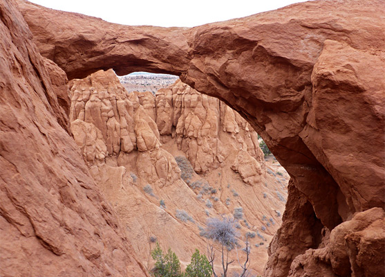
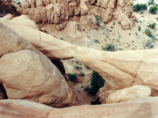
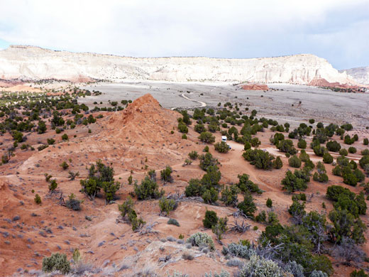
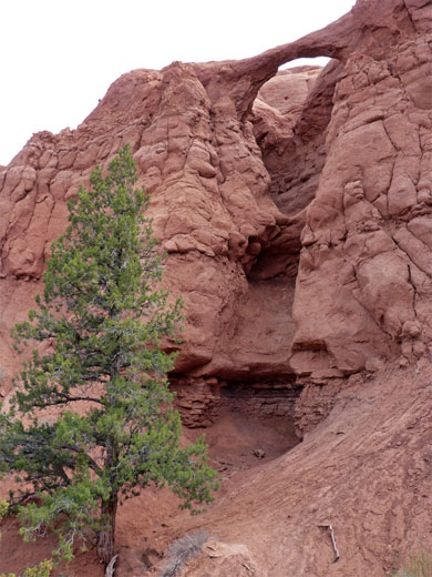
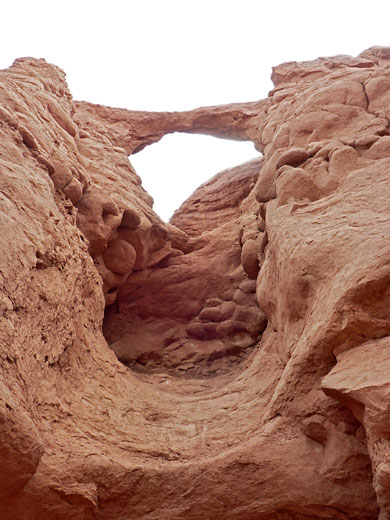
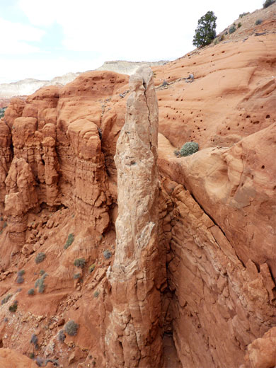
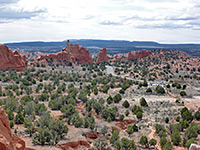
Southeast of the central area of Kodachrome Basin where most of the formations are found, several unpaved tracks cross the mostly flat surrounding land; one goes to the large sand pipe known as Chimney Rock, while another forks south to the trailhead for Shakespeare Arch, which was a concealed feature at the edge of an isolated mesa of Entrada sandstone, and the only significant arch in the park, however it collapsed in May 2019.
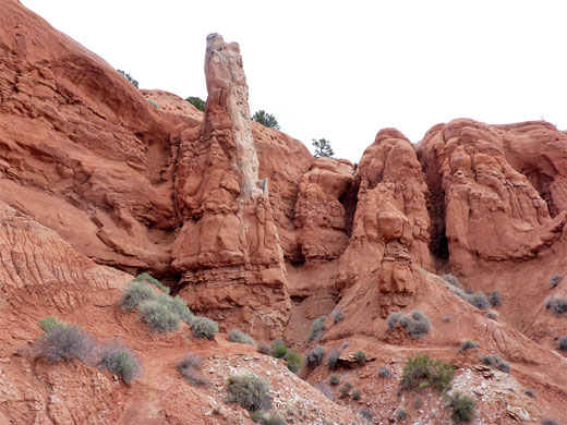
The arch was just visible from the main road yet was not discovered until 1976, by a ranger searching for a coyote den in a seemingly unremarkable corner of the region, since which time it had become one of Kodachrome Basin's most popular sites, and the remains may be reached by an easy, quarter mile hike on a trail which continues past a large sand pipe (The Sentinel), rounds the far side of the mesa then returns to the start.
The main trail stays near the base of the mesa, which has the arch and sand pipe along its steeper west side, and various minor ridges and valleys on the less sloping east side, while a partial alternative route climbs to the top of the mesa; a briefly steep path that has better views of the surrounding landscape though not necessarily of the (site of the) arch, as this is out of sight, however it may be reached by a short diversion.
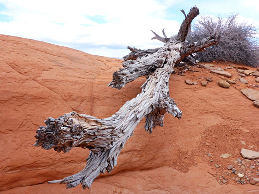
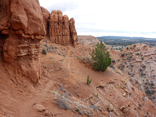
From the parking lot, the trail moves up and down a few times, over little ravines and sandy mounds, past scattered shrubs and cacti, and soon reaches a viewpoint below the former arch, which was only recognisable as such when directly opposite. The span formed at the top of a line of cliffs, across a near vertical gully, and was well enough viewed from the path, though a short spur leads to a sandy slope directly beneath, and a more close-up perspective. After the gully, the path continues past a protruding cliff, round the head of a ledgy ravine and on to the Sentinel, which is colored red at its wide base and white at the narrower tip.
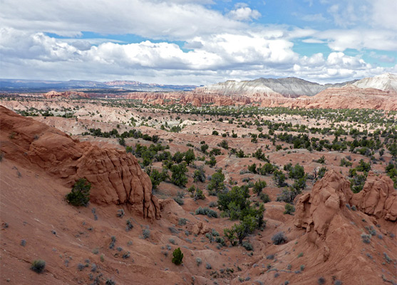
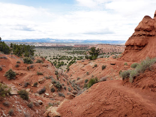
The trail proceeds south, through a gap near the end of a line of pinnacles, and across the southern edge of the mesa, now quite high above the undulating earthen hills below, giving good views towards the distant Paria River, before turning north, back towards the sandstone formations of the mesa. Another vertical ravine, similar in form to the one below the arch, is topped by a thin slab of rock, so this is likely to become a replacement arch, perhaps in a few centuries.
A junction marks the start of the more interesting upper route; up a few roughly-cut steps in a sandstone slope and over a rocky brow to the flat plateau above the Sentinel, and on to the vicinity of the arch. A very short walk west leads to the edge of the mesa and the top of a little gully, which can be followed a short distance, down two drops each of several feet, to a viewpoint directly opposite the remains of the arch - the view formerly used in park literature. Beyond here, the trail swiftly zig-zags down the slope on the north side of the mesa to another junction, with the lower route, and ends 300 feet further at the parking lot.
The arch was just visible from the main road yet was not discovered until 1976, by a ranger searching for a coyote den in a seemingly unremarkable corner of the region, since which time it had become one of Kodachrome Basin's most popular sites, and the remains may be reached by an easy, quarter mile hike on a trail which continues past a large sand pipe (The Sentinel), rounds the far side of the mesa then returns to the start.
The main trail stays near the base of the mesa, which has the arch and sand pipe along its steeper west side, and various minor ridges and valleys on the less sloping east side, while a partial alternative route climbs to the top of the mesa; a briefly steep path that has better views of the surrounding landscape though not necessarily of the (site of the) arch, as this is out of sight, however it may be reached by a short diversion.
The Arch
From the parking lot, the trail moves up and down a few times, over little ravines and sandy mounds, past scattered shrubs and cacti, and soon reaches a viewpoint below the former arch, which was only recognisable as such when directly opposite. The span formed at the top of a line of cliffs, across a near vertical gully, and was well enough viewed from the path, though a short spur leads to a sandy slope directly beneath, and a more close-up perspective. After the gully, the path continues past a protruding cliff, round the head of a ledgy ravine and on to the Sentinel, which is colored red at its wide base and white at the narrower tip.
Edge of the Mesa
The trail proceeds south, through a gap near the end of a line of pinnacles, and across the southern edge of the mesa, now quite high above the undulating earthen hills below, giving good views towards the distant Paria River, before turning north, back towards the sandstone formations of the mesa. Another vertical ravine, similar in form to the one below the arch, is topped by a thin slab of rock, so this is likely to become a replacement arch, perhaps in a few centuries.
The Upper Trail
A junction marks the start of the more interesting upper route; up a few roughly-cut steps in a sandstone slope and over a rocky brow to the flat plateau above the Sentinel, and on to the vicinity of the arch. A very short walk west leads to the edge of the mesa and the top of a little gully, which can be followed a short distance, down two drops each of several feet, to a viewpoint directly opposite the remains of the arch - the view formerly used in park literature. Beyond here, the trail swiftly zig-zags down the slope on the north side of the mesa to another junction, with the lower route, and ends 300 feet further at the parking lot.
Shakespeare Arch Trail - Similar Hikes
All Contents © Copyright The American Southwest | Comments and Questions | Contribute | Affiliate Marketing Disclosure | Site Map