Herdina Park
Isolated group of fins and ravines containing two major arches (Leaping Arch and Eye of the Whale), reached by a 4WD track. A short, unofficial trail leads to the arches, while more of the area can be seen by cross-country hiking
Length: 1 mile (loop) to the arches, or around 4 miles (loop) to circle the whole area. Plus 3 miles if using the 2WD trailhead
Elevation change: 40 feet, 250 feet
Difficulty: Easy, moderate
Type: Loop
Usage: Low
Season: All year, though very hot in summer
Trailheads: 2WD; along Road 378, west of Balanced Rock, or (4WD) along a rougher track forking off to the north
Rating (1-5): ★★★★★
Elevation change: 40 feet, 250 feet
Difficulty: Easy, moderate
Type: Loop
Usage: Low
Season: All year, though very hot in summer
Trailheads: 2WD; along Road 378, west of Balanced Rock, or (4WD) along a rougher track forking off to the north
Rating (1-5): ★★★★★

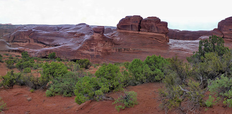
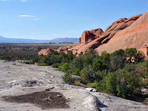
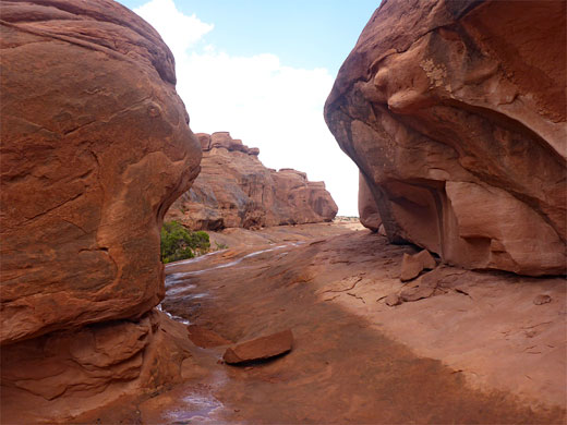
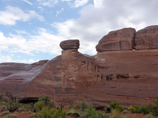
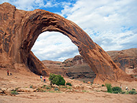
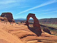
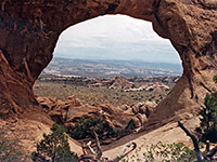
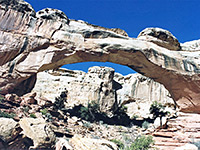
Herdina Park is an isolated group of Entrada sandstone fins and ravines towards the west side of Arches National Park, about one mile across, surrounded on all sides by flat, sandy, sparsely vegetated desert. Contained within are two main arches - Eye of the Whale and Leaping Arch (also known as Beckwith Arch), both along the north edge of the formations and quite easily viewed - plus several smaller, more hidden spans closer to the center.
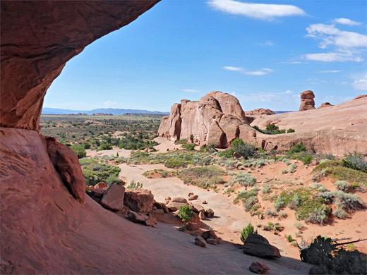
The place is very little visited despite being clearly visible from the main road, in the vicinity of Balanced Rock, since although reached by a vehicle track, the area is not signposted and most of the route requires 4WD. From the 4WD parking area, both arches can be seen on a loop of one mile, while for longer hikes, a circuit all around the formations is approximately four miles, more if entering some of the ravines; the rocks form a mostly continuous line of cliffs along the north and east sides, while to the west and south they break up into several narrow valleys, some branching at the upper end into lesser ravines, so a full day could be spent exploring all areas.
The distance from the 2WD parking area to the closest arch (Eye of the Whale) is 2 miles along the vehicle track or 1.5 miles cross-country, hence the shortest round trip distance from here is 4 miles just to the arches or around 7 miles including a walk all around the rocky area.
The first part of the route to Herdina Park is along Willow Springs Road (BLM 378) which starts in the west along US 191, enters the park after a few miles, crosses Willow Flats and meets the scenic drive right opposite the parking area for Balanced Rock. The initial eastern section is fine for all vehicles, as it passes a small picnic area and a maintenance point then arrives at a junction after 0.8 miles, the 2WD parking place. Both onwards branches are signed as 4WD only, though the main road, continuing west, stays smooth for another mile or so. The north fork leads to Herdina Park then eventually to the Klondike Bluffs. Willow Springs Road was the original entrance to the national park, in use until 1958.
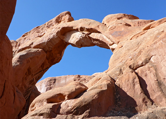
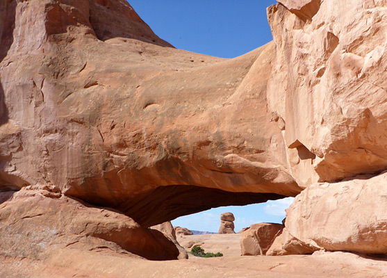
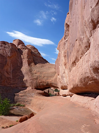
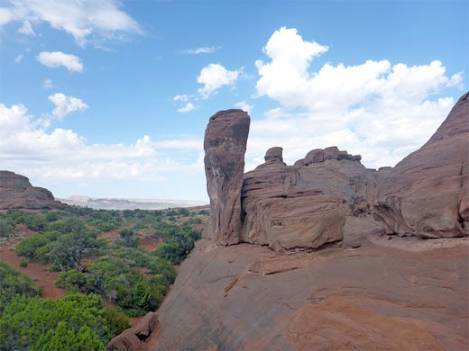
If starting at the 2WD parking place, walking along the track is probably the easiest option to reach Herdina Park, though a cross-country hike saves about half a mile, by traversing generally gentle terrain - flat, treeless and sometimes rocky, while aiming for the north side of the prominent sandstone outcrop. The northeast edge of the park is bordered by a flat pavement of white sandstone, fractured into polygonal patterns, this a component of the Dewey Bridge member of the Entrada sandstone, which underlies the main, arch-forming Slickrock member. Eye of the Whale Arch is just south of the south end of the white area, its general location visible from some distance, though the opening is hidden until close up; a small cavity beneath a thick, orange fin. The west side slopes down further, to a slickrock valley that has some pinnacles on the far side. This arch is the most visited in Herdina Park; nearby Leaping Arch seems to be less well-known, though is also easy to reach, by a short northwards walk along a faint path, round a shallow corner and just beyond the far end of the white sandstone pavement. The arch is quite high up, above a bushy sandbank and a boulder-covered slope, and it has a jagged span above a relatively large opening.
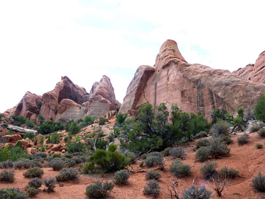
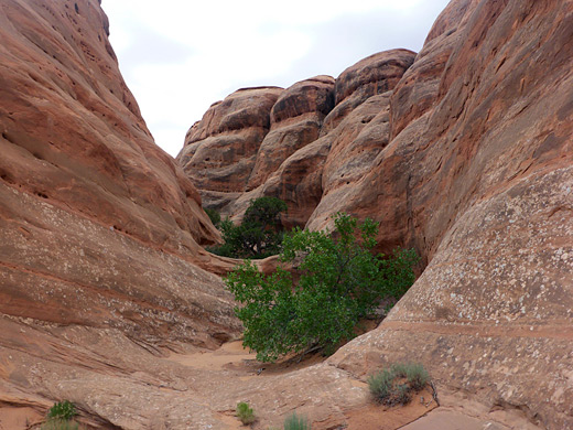
Past Leaping Arch, the line of cliffs continues westwards for half a mile then ends abruptly, and to the south is the first of several ravines, lined by fins and smooth sandstone slopes. The cliffs on the far side extend further west and then beyond, after a wide, sloping plateau, are several longer, narrower ravines, angled back northeast towards the two arches. All are separated by unclimbable fins, so a full exploration would be quite time-consuming. The cliffs along the east edge of Herdina Park are generally less high, and broken into smaller ravines.
The place is very little visited despite being clearly visible from the main road, in the vicinity of Balanced Rock, since although reached by a vehicle track, the area is not signposted and most of the route requires 4WD. From the 4WD parking area, both arches can be seen on a loop of one mile, while for longer hikes, a circuit all around the formations is approximately four miles, more if entering some of the ravines; the rocks form a mostly continuous line of cliffs along the north and east sides, while to the west and south they break up into several narrow valleys, some branching at the upper end into lesser ravines, so a full day could be spent exploring all areas.
The distance from the 2WD parking area to the closest arch (Eye of the Whale) is 2 miles along the vehicle track or 1.5 miles cross-country, hence the shortest round trip distance from here is 4 miles just to the arches or around 7 miles including a walk all around the rocky area.
Herdina Park Trailheads
The first part of the route to Herdina Park is along Willow Springs Road (BLM 378) which starts in the west along US 191, enters the park after a few miles, crosses Willow Flats and meets the scenic drive right opposite the parking area for Balanced Rock. The initial eastern section is fine for all vehicles, as it passes a small picnic area and a maintenance point then arrives at a junction after 0.8 miles, the 2WD parking place. Both onwards branches are signed as 4WD only, though the main road, continuing west, stays smooth for another mile or so. The north fork leads to Herdina Park then eventually to the Klondike Bluffs. Willow Springs Road was the original entrance to the national park, in use until 1958.
Herdina Arches
If starting at the 2WD parking place, walking along the track is probably the easiest option to reach Herdina Park, though a cross-country hike saves about half a mile, by traversing generally gentle terrain - flat, treeless and sometimes rocky, while aiming for the north side of the prominent sandstone outcrop. The northeast edge of the park is bordered by a flat pavement of white sandstone, fractured into polygonal patterns, this a component of the Dewey Bridge member of the Entrada sandstone, which underlies the main, arch-forming Slickrock member. Eye of the Whale Arch is just south of the south end of the white area, its general location visible from some distance, though the opening is hidden until close up; a small cavity beneath a thick, orange fin. The west side slopes down further, to a slickrock valley that has some pinnacles on the far side. This arch is the most visited in Herdina Park; nearby Leaping Arch seems to be less well-known, though is also easy to reach, by a short northwards walk along a faint path, round a shallow corner and just beyond the far end of the white sandstone pavement. The arch is quite high up, above a bushy sandbank and a boulder-covered slope, and it has a jagged span above a relatively large opening.
Fins and Ravines
Past Leaping Arch, the line of cliffs continues westwards for half a mile then ends abruptly, and to the south is the first of several ravines, lined by fins and smooth sandstone slopes. The cliffs on the far side extend further west and then beyond, after a wide, sloping plateau, are several longer, narrower ravines, angled back northeast towards the two arches. All are separated by unclimbable fins, so a full exploration would be quite time-consuming. The cliffs along the east edge of Herdina Park are generally less high, and broken into smaller ravines.
Herdina Park - Similar Hikes
All Contents © Copyright The American Southwest | Comments and Questions | Contribute | Affiliate Marketing Disclosure | Site Map