Sand Dune, Broken, Tapestry and Skyline Arches, Arches National Park
Utah > Arches National Park > Hiking > Sand Dune, Broken, Tapestry and Skyline Arches

Sand Dune, Broken, Tapestry and Skyline Arches
Four contrasting arches, each viewable individually along short paths, but more enjoyably seen via a loop hike, crossing sand and slickrock landscape near the end of the scenic drive
Length: 2.5 miles, round trip
Elevation change: level overall
Difficulty: Easy
Type: Loop
Usage: Low to medium
Season: All year
Trailhead: Pullout on the east side of the road
Rating (1-5): ★★★★★
Elevation change: level overall
Difficulty: Easy
Type: Loop
Usage: Low to medium
Season: All year
Trailhead: Pullout on the east side of the road
Rating (1-5): ★★★★★

Four large arches, each with a different character, may be visited on a 2.5 mile loop trail beginning 21.5 miles along the scenic drive in Arches National Park; together with the 7.5 mile Devils Garden Trail, starting at the end of the road one mile further, the two routes can be combined for a full day of hiking. The first site is Sand Dune Arch, hidden in a narrow ravine, followed by the much more open Broken Arch, the lesser-known Tapestry Arch and finally the dramatic Skyline Arch, a graceful span at the top of a narrow ridge.
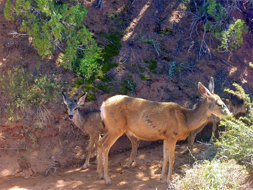
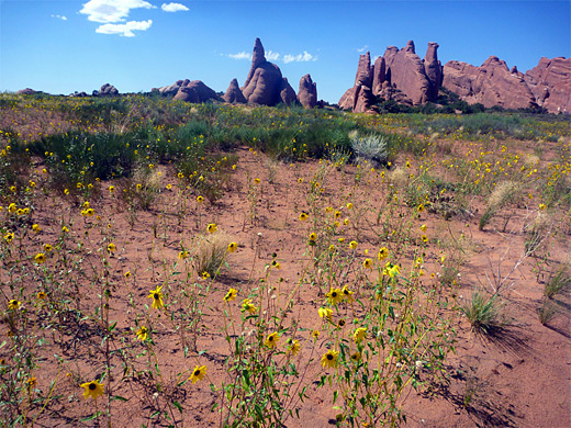
Along the way are many good viewpoints of the surrounding fins, pinnacles and slickrock, and across the wide valley of Salt Wash to the La Sal Mountains on the horizon. Wildlife is quite plentiful amongst the bushes and dry washes en route, especially lizards and mule deer. Each arch can also be visited individually by shorter trails but the full loop is easy, and a leisurely walk takes less than 2 hours.
Arches overview map.
Topographic map of Sand Dune, Broken, Tapestry and Skyline Arches.
Sand Dune is the most popular of the four arches as it is just 0.3 miles from the scenic drive, on a wide trail that starts at a newly enlarged parking area 1.5 miles before the end of the road at Devils Garden. The path approaches a sandstone outcrop and veers right, into a shady, sandy-floored ravine between vertical rocks, and soon arrives at the arch, which is named for a large pile of soft, wind-blown sand underneath. The formation is not so easy or interesting to photograph since it has formed close to one wall of the canyon and is enclosed on all sides by other high rocks. Beyond, the ravine narrows and becomes too steep to follow.
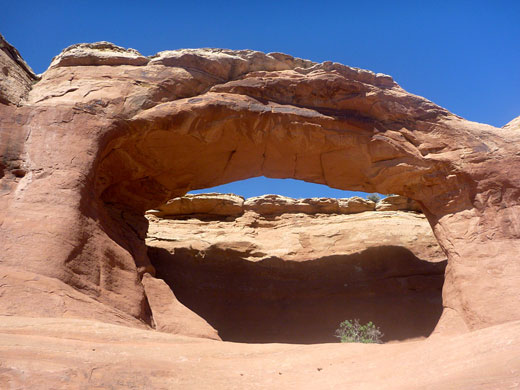
Not so many people walk to the next arch (Broken), half a mile away across a grassy flat (good for wildflowers in summer), along a dry wash and over whitish slickrock slopes. This arch is bigger and much more photogenic, with an opening 60 feet wide, visible from the road, that allows unobscured views through from either side. A crack runs down the middle of the span but the structure looks solid enough. The trail continues under the arch and climbs a little through undulating rocks then traverses flatter, pinyon/juniper-covered land with good views of the formations of Devils Garden to the northwest, and reaches the junction with a short spur trail to arch number 3, Tapestry. Like Sand Dune Arch this has a sheer cliff behind but the other side is open, and scrambling up behind gives a good perspective of the expansive scenery to the east.
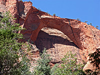
Back on the main trail, the route continues over sandy ground to the Devils Garden Campground, a convenient place to replenish drinking water. Skyline Arch is now visible, at the top of a sandstone fin to the west, and may be reached by a short walk up a huge sand dune. Again the views through the arch, towards the colorful fins and pinnacles below, are quite spectacular. It is easy to climb up to the base of the arch and look down at sheer drop on the far side; 80 feet below is a viewing area - the more usual vantage point - reached by a 0.2 mile trail starting along the road. The loop hike is completed by a connecting path that starts next to site 31 of the campground, climbs gradually and enters another cool ravine between parallel fins, then descends past other sandstone monoliths and joins the trail from Broken Arch at the edge of the grassy flats.
Along the way are many good viewpoints of the surrounding fins, pinnacles and slickrock, and across the wide valley of Salt Wash to the La Sal Mountains on the horizon. Wildlife is quite plentiful amongst the bushes and dry washes en route, especially lizards and mule deer. Each arch can also be visited individually by shorter trails but the full loop is easy, and a leisurely walk takes less than 2 hours.
Maps
Arches overview map.
Topographic map of Sand Dune, Broken, Tapestry and Skyline Arches.
Sand Dune Arch
Sand Dune is the most popular of the four arches as it is just 0.3 miles from the scenic drive, on a wide trail that starts at a newly enlarged parking area 1.5 miles before the end of the road at Devils Garden. The path approaches a sandstone outcrop and veers right, into a shady, sandy-floored ravine between vertical rocks, and soon arrives at the arch, which is named for a large pile of soft, wind-blown sand underneath. The formation is not so easy or interesting to photograph since it has formed close to one wall of the canyon and is enclosed on all sides by other high rocks. Beyond, the ravine narrows and becomes too steep to follow.
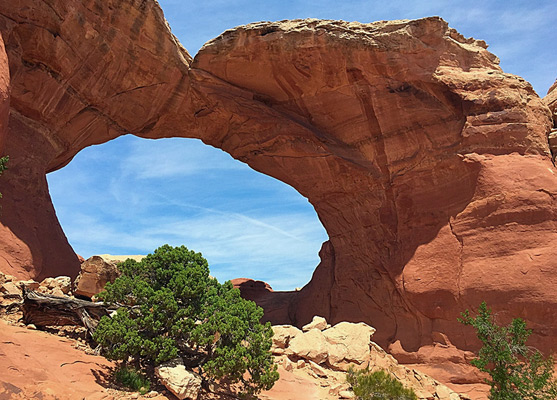
Broken Arch and Tapestry Arch
Not so many people walk to the next arch (Broken), half a mile away across a grassy flat (good for wildflowers in summer), along a dry wash and over whitish slickrock slopes. This arch is bigger and much more photogenic, with an opening 60 feet wide, visible from the road, that allows unobscured views through from either side. A crack runs down the middle of the span but the structure looks solid enough. The trail continues under the arch and climbs a little through undulating rocks then traverses flatter, pinyon/juniper-covered land with good views of the formations of Devils Garden to the northwest, and reaches the junction with a short spur trail to arch number 3, Tapestry. Like Sand Dune Arch this has a sheer cliff behind but the other side is open, and scrambling up behind gives a good perspective of the expansive scenery to the east.
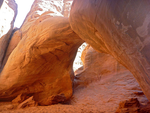

Skyline Arch
Back on the main trail, the route continues over sandy ground to the Devils Garden Campground, a convenient place to replenish drinking water. Skyline Arch is now visible, at the top of a sandstone fin to the west, and may be reached by a short walk up a huge sand dune. Again the views through the arch, towards the colorful fins and pinnacles below, are quite spectacular. It is easy to climb up to the base of the arch and look down at sheer drop on the far side; 80 feet below is a viewing area - the more usual vantage point - reached by a 0.2 mile trail starting along the road. The loop hike is completed by a connecting path that starts next to site 31 of the campground, climbs gradually and enters another cool ravine between parallel fins, then descends past other sandstone monoliths and joins the trail from Broken Arch at the edge of the grassy flats.
Nearby Trails
Sand Dune Arch - Similar Hikes


All Contents © Copyright The American Southwest | Comments and Questions | Contribute | Affiliate Marketing Disclosure | Site Map