Druid Arch Trail, Canyonlands National Park
Utah > Canyonlands National Park > The Needles > Hiking > Druid Arch
Druid Arch
Spectacular, isolated, angular arch with a main opening and two smaller ones, standing above the far upper end of Elephant Hill Canyon; one of the highlights of the Needles District. reached by a relatively easy hike over open plateau then along a rocky streambed
Length: 5.4 miles, or 7.4 miles from Salt Flat
Elevation change: 650 feet
Difficulty: Moderate
Type: One way. Can be combined with other trails through Chesler Park or Big Spring Canyon, to form a loop
Usage: Medium
Season: Fall, winter, spring are best, though the route is partly shaded in summer
Trailhead: End of the Elephant Hill Access Road, or Salt Flat campground
Rating (1-5): ★★★★★

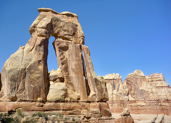
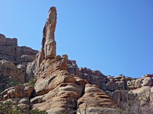
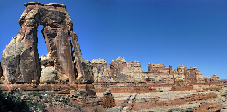
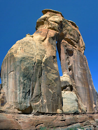
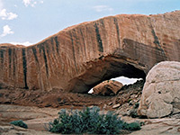
Second in popularity only to Chesler Park among hiking destinations in the Needles district of Canyonlands National Park, Druid Arch stands high above the far upstream end of Elephant Canyon, surrounded by slickrock benches and multicolored pinnacles. The isolated, freestanding arch projects outwards at right angles from the Cedar Mesa sandstone cliffs and is notable both for its height (450 feet) and shape - sharply angular, with two main openings and one smaller. The formation is named because of the resemblance to Stonehenge in England, a place long associated with druids.
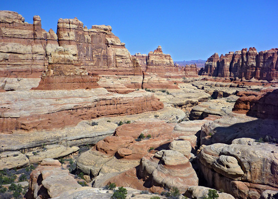
Besides the arch itself, the view downcanyon from its base is also spectacular, as the partly bushy streambed is hidden beneath red benches so the canyon appears entirely made of undulating red sandstone, lined by white spires and fins, with a narrow slit along the base. Over a dozen other major arches are found in this area but Druid is the easiest reached and one of the most unusual. The hike to the arch is 5.4 miles by the shortest trail, starting from the Elephant Hill trailhead, or 7.4 miles from Salt Flat Campground (formerly Squaw Flat); both routes are relatively easy with little overall elevation change, either along canyon floors or across open plateaus.
Topographic map of Druid Arch and the Needles.
18 views along the trail to Druid Arch.
Most hikes to Druid Arch start from the Elephant Hill Trailhead, 3 miles from Salt Flat Campground along a dirt track that is usually fine for all cars and small to medium RVs. The first part of the trail is also the main route to Chesler Park so is rather busy, but fewer people walk up Elephant Canyon to the arch.
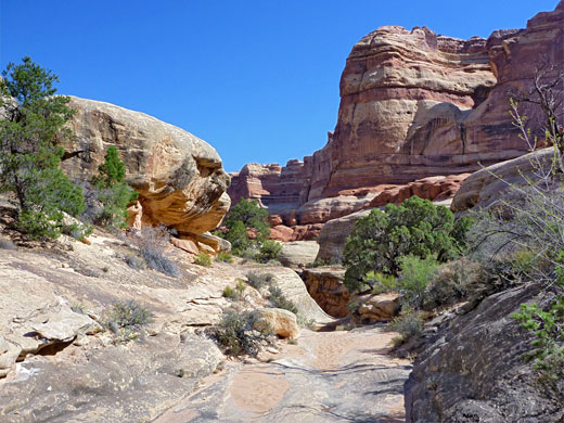
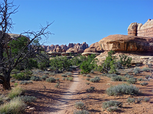
The well worn path climbs above the parking lot, over several benches that make good vantage points for looking at jeeps climbing Elephant Hill Road opposite, and then levels out, crossing a mix of sand and slickrock parallel to a line of tall, thin fins to the west; the east side is open, and the views extend across to the distant red cliffs lining the Needles entrance road. The trail passes through several gaps in lines of lesser pinnacles and reaches a junction after 1.5 miles, with a route from Salt Flat (3.5 miles). The second junction is 0.6 miles further, after descending a narrow, shady, sloping cleft through a line of cliffs (like a smaller version of the Joint Trail further south), down to the sandy floor of Elephant Canyon. A path forks west, up the far side of the canyon towards Chesler Park, while the Druid Arch route continues south, mostly right along the stream bed, for 0.8 miles to a third junction, signed Salt Flat 5.9 miles.
The Druid Arch Trail proceeds further south along Elephant Canyon, past surroundings unchanged since joining the ravine - bushy sides below relatively thin-layered sandstone, colored various light and dark shades, and covered towards the base by jumbled, fallen rocks, the drainage not yet very deep nor very spectacular, but after a while the mostly sandy floor gives way to slickrock, so walking becomes easier and the canyon more interesting. Junction four is reached just as the walls start to become higher and more impressive, though this intersection is easy to miss, especially if walking along the stream bed, as a the sign is beside the path, here just above on the east side. The trail to the right (west) provides a short-cut to Chesler Park, ascending quite steeply up the canyon walls via some narrow ledges, turning away up a little side-ravine, past the openings of two short tunnels, and out to a plateau beneath a sheer ridge, with expansive views eastwards. The next stretch climbs gradually, becoming closer to the ridge, then passes through a narrow gap, out to a sagebrush flat, followed by a descent into the park.
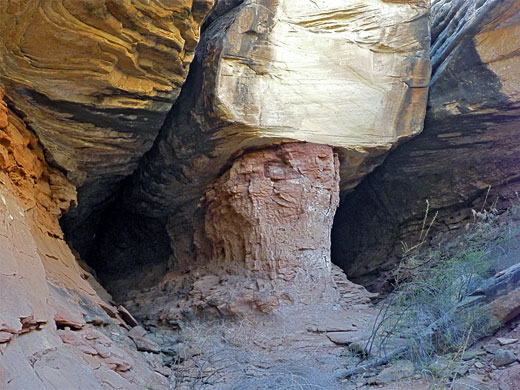
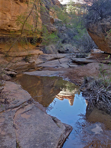
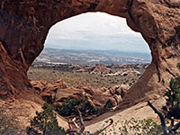
The main Druid Arch path remains in the streambed another half mile or so then cuts left at a bench, another somewhat hidden section; ahead are some shallow, seasonal pools of drinkable water, then a big pour-over pool in a narrow, overgrown place, below a sheer drop. The path is now about 40 feet above but soon rejoins the streamway, a little way above the dryfall. Next are more rocky passages, some narrow channels and a short sandstone staircase, before the path reaches the end of the drainage, which is enclosed on three sides by vertical walls and big, red/yellow pinnacles, typical of the Needles. An optional ladder and railing is installed in one place to ascend a short cliff, though this obstacle is quite easy climbed without. The final part of the trail climbs a slickrock gully, a boulder slope and a soil covered hillside, right to the base of the arch, which is best photographed in the morning, when the sun shines on the front (east) side. When first viewed, from below, the arch is end-on so it looks like a protruding fin or pinnacle. The view downcanyon is quite special, along the red and white upper section of the drainage, towards more distant spires and ridges.
Besides the arch itself, the view downcanyon from its base is also spectacular, as the partly bushy streambed is hidden beneath red benches so the canyon appears entirely made of undulating red sandstone, lined by white spires and fins, with a narrow slit along the base. Over a dozen other major arches are found in this area but Druid is the easiest reached and one of the most unusual. The hike to the arch is 5.4 miles by the shortest trail, starting from the Elephant Hill trailhead, or 7.4 miles from Salt Flat Campground (formerly Squaw Flat); both routes are relatively easy with little overall elevation change, either along canyon floors or across open plateaus.
Map
Topographic map of Druid Arch and the Needles.
Photographs
18 views along the trail to Druid Arch.
Druid Arch Trailhead
Most hikes to Druid Arch start from the Elephant Hill Trailhead, 3 miles from Salt Flat Campground along a dirt track that is usually fine for all cars and small to medium RVs. The first part of the trail is also the main route to Chesler Park so is rather busy, but fewer people walk up Elephant Canyon to the arch.
Elephant Hill to Elephant Canyon
The well worn path climbs above the parking lot, over several benches that make good vantage points for looking at jeeps climbing Elephant Hill Road opposite, and then levels out, crossing a mix of sand and slickrock parallel to a line of tall, thin fins to the west; the east side is open, and the views extend across to the distant red cliffs lining the Needles entrance road. The trail passes through several gaps in lines of lesser pinnacles and reaches a junction after 1.5 miles, with a route from Salt Flat (3.5 miles). The second junction is 0.6 miles further, after descending a narrow, shady, sloping cleft through a line of cliffs (like a smaller version of the Joint Trail further south), down to the sandy floor of Elephant Canyon. A path forks west, up the far side of the canyon towards Chesler Park, while the Druid Arch route continues south, mostly right along the stream bed, for 0.8 miles to a third junction, signed Salt Flat 5.9 miles.
Elephant Canyon, and a Route to Chesler Park
The Druid Arch Trail proceeds further south along Elephant Canyon, past surroundings unchanged since joining the ravine - bushy sides below relatively thin-layered sandstone, colored various light and dark shades, and covered towards the base by jumbled, fallen rocks, the drainage not yet very deep nor very spectacular, but after a while the mostly sandy floor gives way to slickrock, so walking becomes easier and the canyon more interesting. Junction four is reached just as the walls start to become higher and more impressive, though this intersection is easy to miss, especially if walking along the stream bed, as a the sign is beside the path, here just above on the east side. The trail to the right (west) provides a short-cut to Chesler Park, ascending quite steeply up the canyon walls via some narrow ledges, turning away up a little side-ravine, past the openings of two short tunnels, and out to a plateau beneath a sheer ridge, with expansive views eastwards. The next stretch climbs gradually, becoming closer to the ridge, then passes through a narrow gap, out to a sagebrush flat, followed by a descent into the park.
The Arch
The main Druid Arch path remains in the streambed another half mile or so then cuts left at a bench, another somewhat hidden section; ahead are some shallow, seasonal pools of drinkable water, then a big pour-over pool in a narrow, overgrown place, below a sheer drop. The path is now about 40 feet above but soon rejoins the streamway, a little way above the dryfall. Next are more rocky passages, some narrow channels and a short sandstone staircase, before the path reaches the end of the drainage, which is enclosed on three sides by vertical walls and big, red/yellow pinnacles, typical of the Needles. An optional ladder and railing is installed in one place to ascend a short cliff, though this obstacle is quite easy climbed without. The final part of the trail climbs a slickrock gully, a boulder slope and a soil covered hillside, right to the base of the arch, which is best photographed in the morning, when the sun shines on the front (east) side. When first viewed, from below, the arch is end-on so it looks like a protruding fin or pinnacle. The view downcanyon is quite special, along the red and white upper section of the drainage, towards more distant spires and ridges.
Druid Arch - Similar Hikes
All Contents © Copyright The American Southwest | Comments and Questions | Contribute | Affiliate Marketing Disclosure | Site Map