Cohab Canyon, Frying Pan & Cassidy Arch Trails, Capitol Reef National Park
Utah > Capitol Reef National Park > Hiking > Cohab Canyon, Frying Pan, Cassidy Arch Trails
Cohab Canyon, Frying Pan & Cassidy Arch Trails
Enjoyable loop hike passing varied scenery, including a narrow ravine, an overlook of UT 24 and the Fremont River, high elevation terrain at the top of Capitol Reef, and the huge, hidden span of Cassidy Arch
Length: 10.5 miles round trip, including a 3.5 mile road walk
Elevation change: 800 feet
Difficulty: Moderate
Type: Loop
Usage: High to Cohab Canyon and Cassidy Arch; low to medium for the complete loop
Season: All year; liable to be very hot in summer, however
Trailhead: 1.2 miles along the scenic drive
Rating (1-5): ★★★★★
Elevation change: 800 feet
Difficulty: Moderate
Type: Loop
Usage: High to Cohab Canyon and Cassidy Arch; low to medium for the complete loop
Season: All year; liable to be very hot in summer, however
Trailhead: 1.2 miles along the scenic drive
Rating (1-5): ★★★★★

Two of the most popular paths in Capitol Reef National Park are the 1.5 mile Cohab Canyon Trail, which follows a narrow, hidden, rocky drainage through part of the Waterpocket Fold starting right beside the NPS campground near Fruita, and the 1.75 mile route to Cassidy Arch, an impressive span in the Kayenta sandstone high above Grand Wash. Linking these two is the Frying Pan Trail across open, uneven terrain on top of the reef, and together these three paths form a scenic and varied 10.5 mile loop, though this includes a not quite so interesting 3.5 mile road walk - up the track along Grand Wash then northwards on the park scenic drive back to the trailhead.
Beside the arch and the canyon, the trail also reaches a grand viewpoint on the edge of the cliffs 400 feet above the Fremont River (Fruita Overlook), and has many other far-reaching views, in all directions. En route are examples of the four main rock types in the national park; tall Wingate cliffs around the Fremont River and Grand Wash, the varied red strata of the Kayenta Formation on the top of the reef, Navajo sandstone domes forming the highest summits, and the multicolored Chinle Formation on the west side of the reef, at the start of the trail. The complete loop takes between 4 and 6 hours, unless a car shuttle or lift is available to save about an hour of road walking.
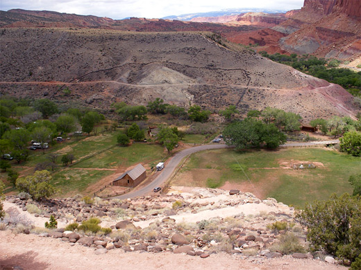
Cohab is the first canyon through Capitol Reef south of the Fremont River, and can be reached from the west side starting by the campground or from the east beginning along highway 24 just opposite the parking area for the Hickman Bridge Trail. Like several other paths in the park, a car shuttle would be useful to avoid retracing steps, though the other alternative of a round trip involving a 3.2 mile walk between the two trailheads along the main road is pleasant enough. Most people just walk from one end then head back the same way. The western trailhead is most used because of its proximity to both the visitor center and the campground; it has a small parking area by the start of the path, or when full, cars may be left a little way back along the road next to an old wooden building (Gifford Barn), which is one of several original structures in the village of Fruita dating from early 20th century.
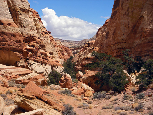
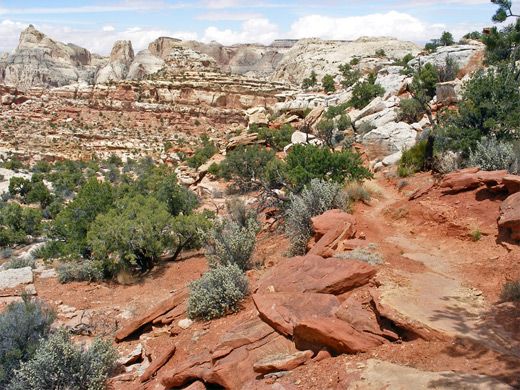
The path climbs steeply 350 feet up clayish slopes of the Chinle Formation via about 20 switchbacks, as far as the base of high, vertical Wingate sandstone cliffs that form the western edge of Capitol Reef. The views are good already, across the campground and the wooded Fremont River valley, over much red, terraced land beyond and to the forested Aquarius Plateau in the distance. After a short level stretch, the trail turns left into the upper end of Cohab Canyon - quite a narrow drainage bordered by broken, potmarked strata and jumbled boulders, composed of rock colored variously brown, red, white and yellow. The rest of the route descends fairly gently along the canyon for just over a mile, passing pour-offs, mini caves, overhangs, residual pools and flat ledges, all of which makes this a popular hike for families with children, who have a fine time playing amongst the interesting rocks. Several short but very narrow side canyons join from both sides, inviting further exploration.
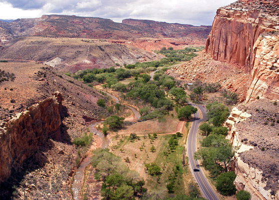
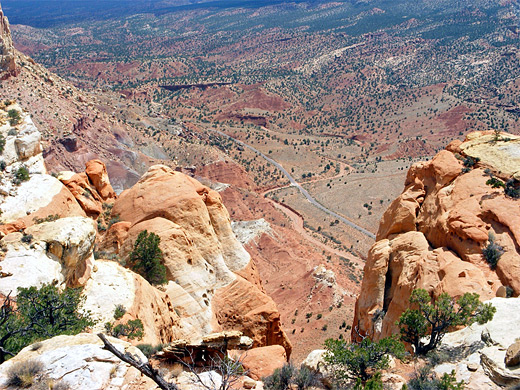
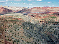
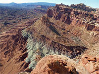
The last section of the Cohab Canyon Trail climbs out of the ravine and descends a hillside to the eastern trailhead along highway 24, but before this are two junctions. Left (north) leads to the overlooks of Fruita and the Fremont River, along a short path that climbs the low cliffs enclosing the canyon and crosses the open plateau beyond then splits, both branches soon reaching the cliff edge for dramatic views up and down the valley, 400 feet below (see 360 degree panorama). These are probably the best easily reached viewpoints in the national park, and this scenic diversion takes just 20 minutes or so. The right junction, nearly opposite, marks the start of the longer, cross-country Frying Pan Trail, a rather less traveled route than the sometimes busy Cohab Canyon Trail.
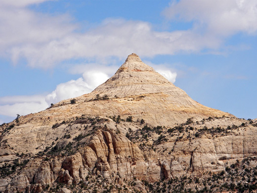
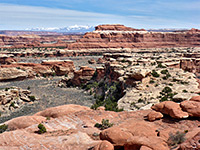
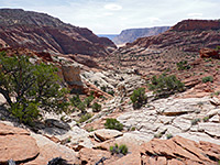
The north end of the Frying Pan Trail begins with a short climb up the side of Cohab Canyon and a traverse of an open, boulder-strewn area to the top of a ridge, then has quite a long descent into the next (unnamed) drainage south. This becomes quite narrow for a while upstream and ends in an unusual enclosed chamber flanked by a wide, vertical cliff at the far end; it can be inspected by walking off-trail up the canyon for half a mile, though the official path continues southwards and begins a long steady ascent to the next summit - the highest point on the trail at 6,450 feet. This section of the route has uninterrupted views all around, over large areas of rock of many different colors, textures and forms, and it climbs at a constant angle of 30°, following the same Kayenta layer for over a mile. The path rounds the head of a shallow ravine and passes below a small butte to the summit, from where much more of the reef to the south becomes visible including the edge of the canyon of Grand Wash, and the easily-recognized shape of Ferns Nipple. This is an eroded cone of cross-bedded Navajo sandstone, named for its resemblance to part of the wife of one of the early settlers of this region. The edge of the reef comes quite close for a while, allowing views down to the scenic drive and the side track along Grand Wash, before the Frying Pan Trail moves away from the cliff edge and starts its long, final descent, curving around a big slickrock bowl to the junction with the Cassidy Arch Trail.
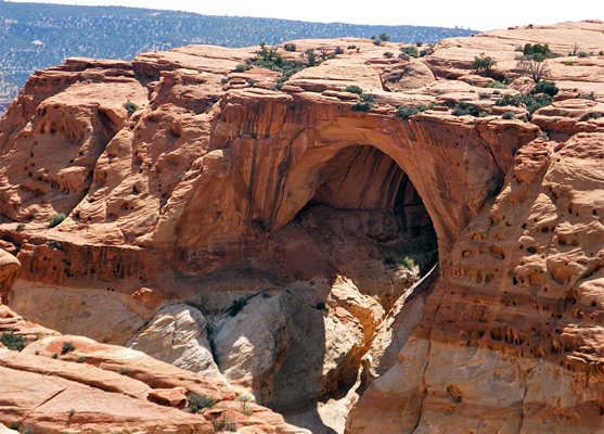
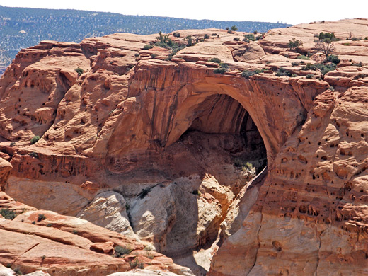
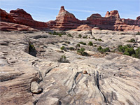
From the south end of the Frying Pan Trail, Cassidy Arch lies less than half a mile southwest, and the path down is quite easy, descending a slope and crossing an area of slickrock where the way ahead is marked by cairns as the recommended route is not always obvious, though the shortest course is not the one indicated. The arch appears quite suddenly; it is hidden from afar because the top of the span is at the same level as the rest of the ground. The perspective from the end of the path, looking close up at the south face of the arch, is good but not the best, as a full sense of scale is missing; better is the more distant sight from further down the trail. Walking across the top of the arch allows a nice view into the colorful, desert varnish-streaked cavity beneath, and just beyond is another fine overlook at the edge of the plateau, where the ground falls away 400 feet straight down to the floor of Grand Wash. There is no chance of climbing underneath Cassidy Arch as the surrounding cliffs are sheer, but it can be approached from below.
Back on the path, beyond the Frying Pan junction the Cassidy Arch Trail soon reaches the edge of Grand Wash again, curves away around a side drainage then descends via switchbacks along the edge of the main gorge all the way to the streambed, reaching the canyon floor 200 yards from the end of the gravel track to the trailhead - also the starting point for the path through the narrows of Grand Wash. It is then 1.2 miles to the paved scenic drive road and a further 2.2 miles back to the Cohab Canyon Trailhead, and the completion of the 10.5 mile loop hike.
Overall, the viewpoints of Cohab Canyon, the Fremont River and Cassidy Arch are very spectacular, and while the Frying Pan Trail is maybe not quite so special, the full loop is one of the best in the park.
Beside the arch and the canyon, the trail also reaches a grand viewpoint on the edge of the cliffs 400 feet above the Fremont River (Fruita Overlook), and has many other far-reaching views, in all directions. En route are examples of the four main rock types in the national park; tall Wingate cliffs around the Fremont River and Grand Wash, the varied red strata of the Kayenta Formation on the top of the reef, Navajo sandstone domes forming the highest summits, and the multicolored Chinle Formation on the west side of the reef, at the start of the trail. The complete loop takes between 4 and 6 hours, unless a car shuttle or lift is available to save about an hour of road walking.
Cohab Canyon Trailhead
Cohab is the first canyon through Capitol Reef south of the Fremont River, and can be reached from the west side starting by the campground or from the east beginning along highway 24 just opposite the parking area for the Hickman Bridge Trail. Like several other paths in the park, a car shuttle would be useful to avoid retracing steps, though the other alternative of a round trip involving a 3.2 mile walk between the two trailheads along the main road is pleasant enough. Most people just walk from one end then head back the same way. The western trailhead is most used because of its proximity to both the visitor center and the campground; it has a small parking area by the start of the path, or when full, cars may be left a little way back along the road next to an old wooden building (Gifford Barn), which is one of several original structures in the village of Fruita dating from early 20th century.
Cohab Canyon
The path climbs steeply 350 feet up clayish slopes of the Chinle Formation via about 20 switchbacks, as far as the base of high, vertical Wingate sandstone cliffs that form the western edge of Capitol Reef. The views are good already, across the campground and the wooded Fremont River valley, over much red, terraced land beyond and to the forested Aquarius Plateau in the distance. After a short level stretch, the trail turns left into the upper end of Cohab Canyon - quite a narrow drainage bordered by broken, potmarked strata and jumbled boulders, composed of rock colored variously brown, red, white and yellow. The rest of the route descends fairly gently along the canyon for just over a mile, passing pour-offs, mini caves, overhangs, residual pools and flat ledges, all of which makes this a popular hike for families with children, who have a fine time playing amongst the interesting rocks. Several short but very narrow side canyons join from both sides, inviting further exploration.
Fremont River Viewpoints
The last section of the Cohab Canyon Trail climbs out of the ravine and descends a hillside to the eastern trailhead along highway 24, but before this are two junctions. Left (north) leads to the overlooks of Fruita and the Fremont River, along a short path that climbs the low cliffs enclosing the canyon and crosses the open plateau beyond then splits, both branches soon reaching the cliff edge for dramatic views up and down the valley, 400 feet below (see 360 degree panorama). These are probably the best easily reached viewpoints in the national park, and this scenic diversion takes just 20 minutes or so. The right junction, nearly opposite, marks the start of the longer, cross-country Frying Pan Trail, a rather less traveled route than the sometimes busy Cohab Canyon Trail.
Frying Pan Trail
The north end of the Frying Pan Trail begins with a short climb up the side of Cohab Canyon and a traverse of an open, boulder-strewn area to the top of a ridge, then has quite a long descent into the next (unnamed) drainage south. This becomes quite narrow for a while upstream and ends in an unusual enclosed chamber flanked by a wide, vertical cliff at the far end; it can be inspected by walking off-trail up the canyon for half a mile, though the official path continues southwards and begins a long steady ascent to the next summit - the highest point on the trail at 6,450 feet. This section of the route has uninterrupted views all around, over large areas of rock of many different colors, textures and forms, and it climbs at a constant angle of 30°, following the same Kayenta layer for over a mile. The path rounds the head of a shallow ravine and passes below a small butte to the summit, from where much more of the reef to the south becomes visible including the edge of the canyon of Grand Wash, and the easily-recognized shape of Ferns Nipple. This is an eroded cone of cross-bedded Navajo sandstone, named for its resemblance to part of the wife of one of the early settlers of this region. The edge of the reef comes quite close for a while, allowing views down to the scenic drive and the side track along Grand Wash, before the Frying Pan Trail moves away from the cliff edge and starts its long, final descent, curving around a big slickrock bowl to the junction with the Cassidy Arch Trail.
Cassidy Arch Trail
From the south end of the Frying Pan Trail, Cassidy Arch lies less than half a mile southwest, and the path down is quite easy, descending a slope and crossing an area of slickrock where the way ahead is marked by cairns as the recommended route is not always obvious, though the shortest course is not the one indicated. The arch appears quite suddenly; it is hidden from afar because the top of the span is at the same level as the rest of the ground. The perspective from the end of the path, looking close up at the south face of the arch, is good but not the best, as a full sense of scale is missing; better is the more distant sight from further down the trail. Walking across the top of the arch allows a nice view into the colorful, desert varnish-streaked cavity beneath, and just beyond is another fine overlook at the edge of the plateau, where the ground falls away 400 feet straight down to the floor of Grand Wash. There is no chance of climbing underneath Cassidy Arch as the surrounding cliffs are sheer, but it can be approached from below.
Grand Wash
Back on the path, beyond the Frying Pan junction the Cassidy Arch Trail soon reaches the edge of Grand Wash again, curves away around a side drainage then descends via switchbacks along the edge of the main gorge all the way to the streambed, reaching the canyon floor 200 yards from the end of the gravel track to the trailhead - also the starting point for the path through the narrows of Grand Wash. It is then 1.2 miles to the paved scenic drive road and a further 2.2 miles back to the Cohab Canyon Trailhead, and the completion of the 10.5 mile loop hike.
Overall, the viewpoints of Cohab Canyon, the Fremont River and Cassidy Arch are very spectacular, and while the Frying Pan Trail is maybe not quite so special, the full loop is one of the best in the park.
Cohab Canyon - Similar Hikes
All Contents © Copyright The American Southwest | Comments and Questions | Contribute | Affiliate Marketing Disclosure | Site Map