Highlights:
Long, narrow ridge of upturned, multicolored strata, topped by huge white domes of Navajo sandstone, and crossed by many narrow canyons. Park includes large areas of desert land on either side, with numerous other eroded formations; it has a scenic drive, backcountry routes and a good selection of trails
Nearby town:
Torrey, 4 miles
Management:
Location:
38.291, -111.261 (visitor center)
Seasons:
All year. Many areas are very hot in summer
Rating (1-5):
★★★★★
Weather:


Capitol Reef NP is part of the Grand Circle itinerary
Featured Hotel
Days Inn by Wyndham Torrey
 Affordable hotel on the east side of Torrey, next to a restaurant, looking across to the wooded slopes of Boulder Mountain. The national park is 3 miles east
Check Rates
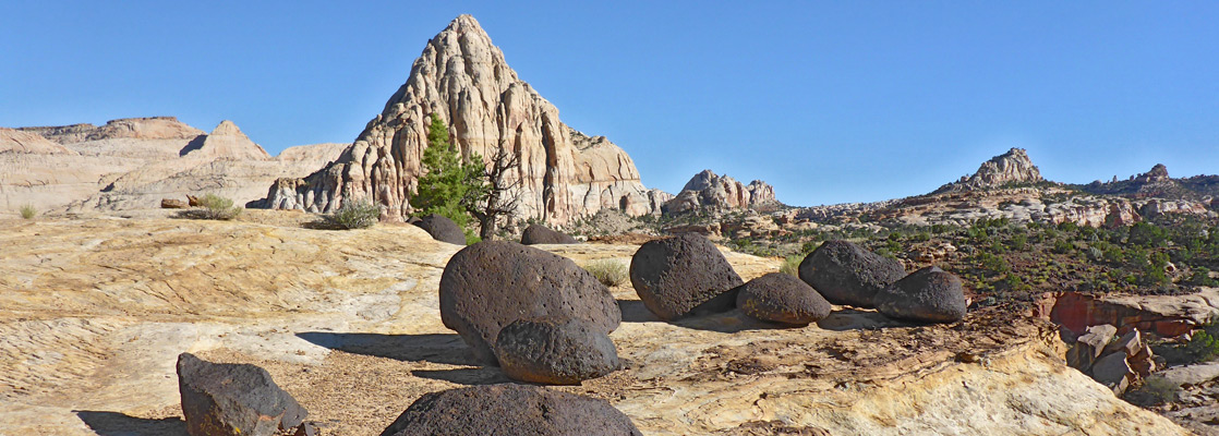
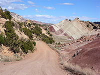
The Waterpocket Fold is a straight, 100 mile long ridge of tilted and layered rock stretching from the Fishlake Mountains in central Utah to Lake Powell in the south. Most is preserved in Capitol Reef National Park, which contains multicolored cliffs, narrow canyons, ridges, arches, spires and domes.
The park is so named because of the resemblance of the many whitish Navajo sandstone domes to the US Capitol building; the 'Reef' refers to the high uplifted ridge running north-south along the fold which presented a considerable barrier to early settlers. Capitol Reef National Park is the second largest in the state, yet is much less visited than others in south Utah, partly due to the rather remote location and perhaps because there is no obvious central attraction.
The park is so named because of the resemblance of the many whitish Navajo sandstone domes to the US Capitol building; the 'Reef' refers to the high uplifted ridge running north-south along the fold which presented a considerable barrier to early settlers. Capitol Reef National Park is the second largest in the state, yet is much less visited than others in south Utah, partly due to the rather remote location and perhaps because there is no obvious central attraction.
Capitol Reef Table of Contents
- Maps of the national park
- Photographs
- Tours of Capitol Reef
- Hwy 24
- Fruita and the Fremont River
- Trails of Capitol Reef
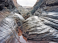
- Narrow canyons of Capitol Reef
- Capitol Reef backcountry; Notom Road and Cathedral Valley
- Wildflowers of Capitol Reef NP
- Nearby places
- Similar places
Location
Capitol Reef National Park maps - overview, trails.
Photographs
Capitol Reef NP, Capitol Gorge Trail, Chimney Rock Trail, Hickman Bridge Trail, Cohab Canyon, Frying Pan, Cassidy Arch Trails.
All Capitol Reef photographs.
Capitol Reef Tours
4WD excursions and horse rides.
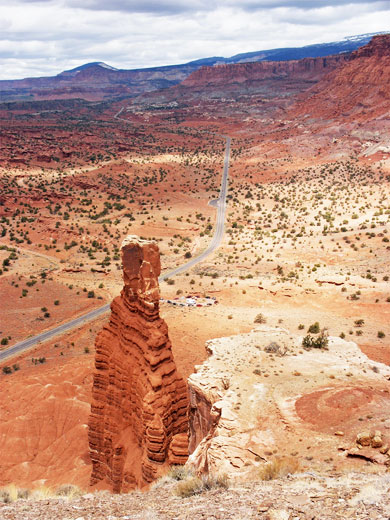
Hwy 24
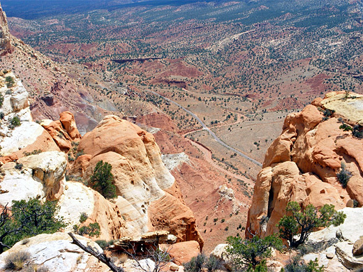
The main road (UT 24) crossing the park east-west gives a flavor of the area and passes close to several of the most famous named features such as Chimney Rock, the deep twisting canyon formed by Sulphur Creek, and Hickman Bridge, a natural arch created by erosion, but it is well worth the national park entry fee to drive the ten mile scenic road which follows the reef itself, starting at the visitor center on UT 24 then south past huge, crumbling, multicolored cliffs with magnificent scenery in all directions. The last few miles are unpaved, and most of the route is narrow and winding so care is needed when driving. The road ends at the start of a narrow steep-walled canyon (Capitol Gorge) that extends for several miles southwards, and a pleasant foot trail runs along its base and passes some ancient Indian petroglyphs; in total there are over a dozen maintained trails along the park roads.
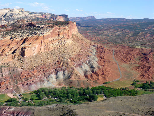
Fruita and the Fremont River
Near the Capitol Reef visitor center is the site of the former Mormon colony of Fruita, established in the 1870s - the good climate of this area and the fertile soil around the Fremont River allowed for successful orchards to be established. The settlers have long since left, departing around the time this area was designated as a national monument in 1937, but fruit is still grown and can be picked in season, for a small fee. Several traditional pioneer dwellings survive and may be visited free of charge. Other attractions along UT 24 include several petroglyph panels near the Hickman Bridge trailhead, a historic cabin, and a powerful waterfall along the Fremont River (formed when the river was rerouted due to road construction in 1962), though access to this has been restricted following several accidents. All other parts of the extensive park backcountry are reached only by cross-country hiking or unpaved roads, the two main routes being Notom-Bullfrog Road and Cathedral Valley Road.
Hiking in Capitol Reef
All Capitol Reef trails - maintained trails, starting along UT 24 or the scenic drive.
Featured Capitol Reef Trails
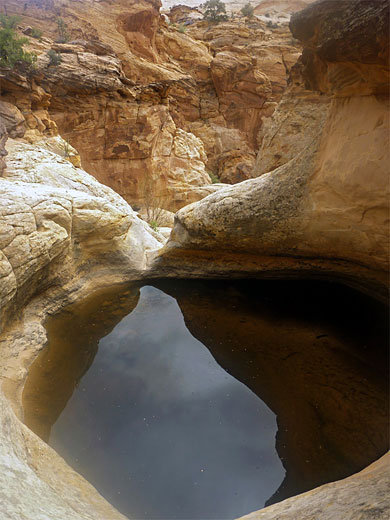
Capitol Gorge
★★★★★
★★★★★
1 miles, level
Easiest explored of the dozen or so narrow canyons cutting through Capitol Reef. Route also passes petroglyphs, historic signatures and some large potholes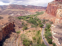
Cohab Canyon, Frying Pan and Cassidy Arch
★★★★★
★★★★★
10.5 miles, 800 feet
Loop hike through varied scenery inckuding a Fremont River overlook, a large arch and rocky terrain on top of the reef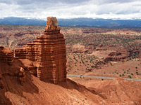
Chimney Rock
★★★★★
★★★★★
3.5 miles, 580 feet
This hike climbs quite steeply up the hills that line the north side of UT 24, then loops around the top of Mummy Cliff while passing close to Chimney Rock, a solitary pillar of Moenkopi sandstone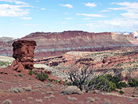
Fremont Gorge Overlook
★★★★★
★★★★★
2 miles, 1,040 feet
The deepest part of the Fremont River canyon is south of Hwy 24 and west of the reef, where for several miles the canyon walls exceed 1,000 feet in height; this path leads to an excellent viewpoint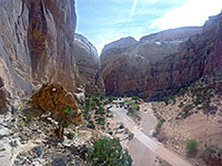
Golden Throne
★★★★★
★★★★★
1.8 miles, 700 feet
This trail climbs the cliffs on the north side of Capitol Gorge, winding around several side ravines to the top of a dome overlooking the gorge to the south and the rounded summit of Golden Throne to the north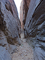
Headquarters Canyon
★★★★★
★★★★★
1.3 miles/1 mile, 250 feet
Short drainage on the east side of Capitol Reef, south of the Burr Trail, with two forks; both contain brief slot sections, and other deep passageways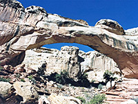
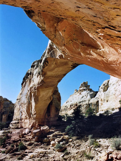
Hickman Bridge
★★★★★
★★★★★
1.2 miles, 400 feet
Sandstone arches are found all over Capitol Reef though most are quite inaccessible. Hickman Bridge is one of the few reached by a maintained trail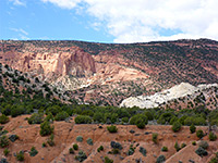
Red Canyon
★★★★★
★★★★★
2.7 miles, 400 feet
Lightly used path to a minor drainage emerging from a cliff-lined amphitheater; starts along Notom-Bullfrog Road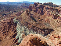
Rim Overlook/Navajo Knobs
★★★★★
★★★★★
2.4/4.9 miles, 1,050/1,600 feet
Steadly ascent to a cliff-edge viewpoint high above Fruita, followed by further climbing, to the top of a sandstone dome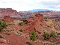
Sunset Point
★★★★★
★★★★★
0.4 miles, level
Easy route that follows the north rim of the canyon of Sulphur Creek to a small summit with panoramic views; a good place for photographing the sunset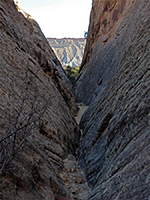
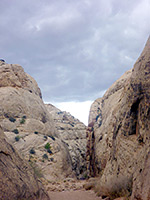
Surprise Canyon
★★★★★
★★★★★
4 miles, 250 feet (loop)
Three forks of a typical Waterpocket Fold canyon; all have short narrows followed by steep slopesCapitol Reef Canyons
Burro Wash
★★★★★
★★★★★
4 miles, 600 feet
Sandy streamway leading to a watery slot; several narrow sections, some quite dark and confined, through greyish rocks of varying textures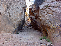
Cottonwood Wash
★★★★★
★★★★★
3 miles, 400 feet
Deep, quite pretty canyon with pools and chokestones. The lower end is moderately enclosed, containing long but shallow slots, and becomes gradually more difficult to follow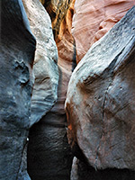
Five Mile Wash
★★★★★
★★★★★
1.8 miles, 150 feet
A large drainage cutting right through Capitol Reef, but one blocked near the lower end, after a very short enclosed section, by a pool and difficult-to-climb dryfall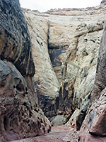
Grand Wash
★★★★★
★★★★★
2.25 miles, 200 feet
Easiest explored of Capitol Reef's narrow canyons, with an official NPS trailhead at either end; route follows a deep gorge that is around 20 feet across at its most confined point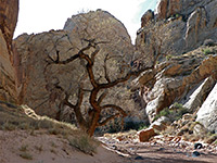
Spring Canyon
★★★★★
★★★★★
4 miles, 250 feet
A hike along the lowest few miles of a deep, twisting ravine that joins the north side of the Fremont River, encountering tall cliffs, alcoves, pools and a seasonal stream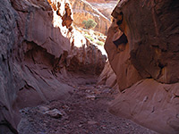
Sheets Gulch
★★★★★
★★★★★
4.7 miles, 350 feet
Lengthy drainage forming shallow but pretty slot sections through nicely colored rocks, with no major obstructions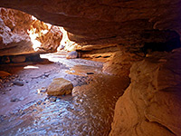
Sulphur Creek
★★★★★
★★★★★
5.3 miles, 500 feet
Although there is no trail through the deep, watery narrows of Sulphur Creek, the route is well enough known to have an NPS sign at the trailhead, shared with Chimney RockCapitol Reef Backcountry
Backcountry areas of the park: Notom-Bullfrog Road and Cathedral Valley Road, including Strike Valley and canyons east of the Waterpocket Fold
Capitol Reef Wildflowers
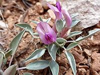
Photographs and descriptions of flowering plants found in the national park
Capitol Reef - Nearby Places
- Factory Butte (25 miles) - prominent peak surrounded by badlands and weathered rocks
- Goblin Valley State Park (61 miles) - thousands of strangely-shaped sandstone formations
- Dixie National Forest (10 miles) - public lands on the forested slopes of Boulder Mountain
Capitol Reef - Similar Places
- Grand Staircase-Escalante National Monument - large region of spectacular cliffs and canyons, including the Coxcomb, a ridge of upturned strata
All Contents © Copyright The American Southwest | Comments and Questions | Contribute | Affiliate Marketing Disclosure | Site Map