Big Spring Canyon, Canyonlands National Park
Utah > Canyonlands National Park > The Needles > Hiking > Big Spring Canyon
Big Spring Canyon
Cross country route down a scenic canyon to a viewpoint of the Colorado River - initially along the streambed, until it descends via some sheer dryfalls, then on a bench on the south side
Length: 5 miles
Elevation change: 500 feet
Difficulty: Moderate
Type: One way, off trail
Usage: Low
Season: All year
Trailhead: West end of the park road
Rating (1-5): ★★★★★
Elevation change: 500 feet
Difficulty: Moderate
Type: One way, off trail
Usage: Low
Season: All year
Trailhead: West end of the park road
Rating (1-5): ★★★★★

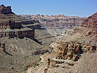
Big Spring Canyon is one of the longer drainages in the Needles region of Canyonlands National Park, flowing northwards from the heart of the needles formations, and meeting Salt Creek which joins the Colorado River a few miles north of the confluence with the Green River. The upper 2.6 miles has a maintained trail, part of a network of hiking routes east of Chesler Park and south of the Salt Flat campground, but the remaining 8 miles to the Colorado are pathless.
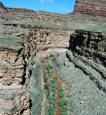
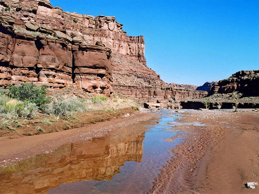
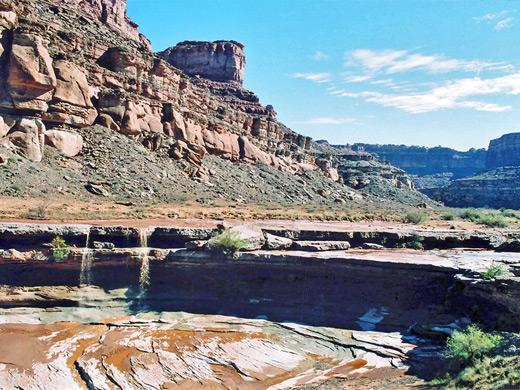
The canyon stays quite shallow for several miles, until the point where it passes the far end of the Needles park road and is crossed by the trail to the Confluence Overlook, below which the drainage starts to cut down into the multi-layered sandstone rock, soon becoming several hundred feet deep. The canyon is enclosed and overgrown at first then is more open, and provides a relatively easy hiking route though wonderful scenery to the Colorado, though not to the actual river since the lower end, after Big Spring Canyon meets the larger canyon of Salt Creek, has several high falls. Instead, walking is possible on benches at either side.
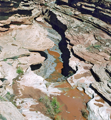
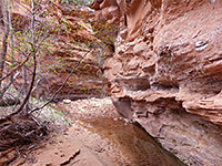
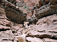
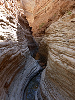
From the carpark at the end of the Needles scenic drive, the flat streambed of Big Spring Canyon is reached after a short walk down the Confluence Trail. The stream drops off just downstream into a large pool and a short confined section, bypassed by walking along a ledge on the east side then climbing down a 10 foot cliff just as the canyon begins to bend to the right. The floor at this point is quite sandy, and the next half mile is filled with boulders, cottonwood trees and bushes, though without any more obstructions. The gorge stays quite narrow around the next two bends then widens and deepens, descending several hundred feet over a section with bigger boulders and pools, before it flattens out, and has less vegetation as the stream flows over several long, level terraces and small waterfalls.
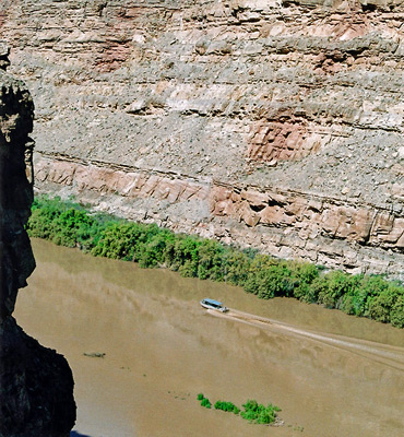
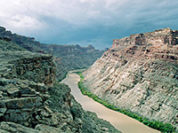
Soon after a second big drop off, passed on the left, Little Spring Canyon joins from the east and the combined canyon is very flat and straight for the next mile, as far as the junction with Salt Creek. This carries a larger amount of water, falling over a U-shaped drop off into a narrowish channel. Lower Salt Creek becomes quite enclosed, flows over more small falls then has the first of several much deeper drops that can't be passed. Instead, the end of the canyon can be reached by easy walking on the west for 2 more miles, round two wide bends and a narrower one, to a grand overlook of the Colorado, 450 feet above the river and a big area of trees and bushes at the mouth of Salt Creek.
An alternative route back is up Little Spring Canyon. This is similar to the main fork, at first being relatively flat and open, becoming less deep after a steeper bouldery section. Next is a short overgrown stretch around a spring, then above, the gorge is quite shallow, its sides formed by just one layer of Cedar Mesa sandstone. The first route out is where the canyon bends 90° to the east; up the cliffs on the right side just after the bend, along a tributary for a while and up a rocky slope to the plateau. The Slickrock Foot Trail is just beyond, leading back to the park road and the carpark after 15 minutes walking.
The canyon stays quite shallow for several miles, until the point where it passes the far end of the Needles park road and is crossed by the trail to the Confluence Overlook, below which the drainage starts to cut down into the multi-layered sandstone rock, soon becoming several hundred feet deep. The canyon is enclosed and overgrown at first then is more open, and provides a relatively easy hiking route though wonderful scenery to the Colorado, though not to the actual river since the lower end, after Big Spring Canyon meets the larger canyon of Salt Creek, has several high falls. Instead, walking is possible on benches at either side.
Upper Big Spring Canyon
From the carpark at the end of the Needles scenic drive, the flat streambed of Big Spring Canyon is reached after a short walk down the Confluence Trail. The stream drops off just downstream into a large pool and a short confined section, bypassed by walking along a ledge on the east side then climbing down a 10 foot cliff just as the canyon begins to bend to the right. The floor at this point is quite sandy, and the next half mile is filled with boulders, cottonwood trees and bushes, though without any more obstructions. The gorge stays quite narrow around the next two bends then widens and deepens, descending several hundred feet over a section with bigger boulders and pools, before it flattens out, and has less vegetation as the stream flows over several long, level terraces and small waterfalls.
Salt Creek
Soon after a second big drop off, passed on the left, Little Spring Canyon joins from the east and the combined canyon is very flat and straight for the next mile, as far as the junction with Salt Creek. This carries a larger amount of water, falling over a U-shaped drop off into a narrowish channel. Lower Salt Creek becomes quite enclosed, flows over more small falls then has the first of several much deeper drops that can't be passed. Instead, the end of the canyon can be reached by easy walking on the west for 2 more miles, round two wide bends and a narrower one, to a grand overlook of the Colorado, 450 feet above the river and a big area of trees and bushes at the mouth of Salt Creek.
Return Route
An alternative route back is up Little Spring Canyon. This is similar to the main fork, at first being relatively flat and open, becoming less deep after a steeper bouldery section. Next is a short overgrown stretch around a spring, then above, the gorge is quite shallow, its sides formed by just one layer of Cedar Mesa sandstone. The first route out is where the canyon bends 90° to the east; up the cliffs on the right side just after the bend, along a tributary for a while and up a rocky slope to the plateau. The Slickrock Foot Trail is just beyond, leading back to the park road and the carpark after 15 minutes walking.
Big Spring Canyon - Similar Hikes
All Contents © Copyright The American Southwest | Comments and Questions | Contribute | Affiliate Marketing Disclosure | Site Map