Elephant Canyon, Canyonlands National Park
Utah > Canyonlands National Park > The Needles > Hiking > Elephant Canyon
Elephant Canyon
Narrow, deepening canyon that provides a route to the Colorado River; hike is along the Confluence Trail for a mile, then down the streambed, and finally across sloping terrain to a viewpoint high above the river
Length: 5 miles
Elevation change: 800 feet
Difficulty: Moderate
Type: One way, mostly off trail
Usage: Low
Season: All year
Trailhead: Big Spring Canyon Overlook, at the end of the scenic drive
Rating (1-5): ★★★★★
Elevation change: 800 feet
Difficulty: Moderate
Type: One way, mostly off trail
Usage: Low
Season: All year
Trailhead: Big Spring Canyon Overlook, at the end of the scenic drive
Rating (1-5): ★★★★★

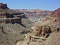
Like Big Spring Canyon, its neighbor to the east, Elephant Canyon is a long drainage that angles northwards from the Needles and is shallow for most of its length but drops down steadily near the lower end towards the junction with the Colorado River. The upper part has a maintained trail running through, the middle is crossed by the famous Elephant Hill 4WD route, and the Confluence Trail passes by towards the lower end, but the 5 miles from here to the Colorado is seldom explored.
Although several drop offs prevent walking to the river's edge, a combination of hiking some parts of the streambed and bench walking reaches a fine overlook of the inner Colorado river canyon after about 2 hours.
5 views of Elephant Canyon.
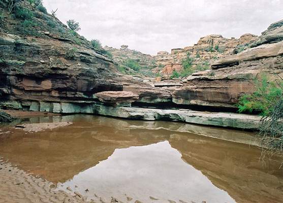
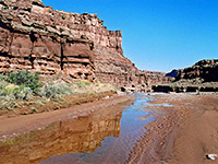
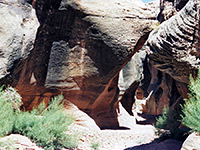
The first part of the hike is along the Confluence Trail, starting from Big Spring Canyon Overlook; down into this canyon, steeply up the far side and over a ridge, across an open grassy area to another low ridge, then down a side ravine to the crossing of Elephant Canyon, which is usually dry but can be flowing up to a foot deep and several meters wide after moderate thunderstorms. Turning right (downstream), the creek curves around a few bends, over several small falls and soon reaches a larger drop into a sheer-walled box canyon without any easy way to climb down. The next entry route appears not to be for 0.6 miles, on the west side, down the second of two steep, adjacent side ravines filled with large boulders.
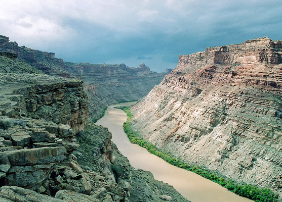
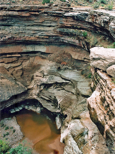
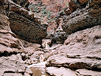
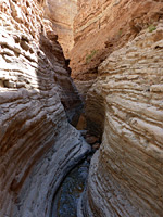
The canyon is now 400 feet deep, V-shaped and usually has a stream flowing through creating small pools and waterfalls, fed by a spring further upstream. After only a short distance, the floor drops again, 50 feet into a narrow chasm enclosed by swirling rocks. Beyond, as Elephant Canyon continues to widen and deepen, are several possible climb down places though more falls at the very lower end prevent access to the river. The Colorado can still be seen by walking on the rim for 1 mile - a straight, level route across rocky slopes - to a viewpoint at 4,420 feet, or scrambling down to a closed point 0.2 miles further. The rim is strewn with quite large pieces of petrified wood and is crossed by a few faint animal tracks but there is no sign of anyone else having ever been here.
Although several drop offs prevent walking to the river's edge, a combination of hiking some parts of the streambed and bench walking reaches a fine overlook of the inner Colorado river canyon after about 2 hours.

Photographs
5 views of Elephant Canyon.
Start of the Hike
The first part of the hike is along the Confluence Trail, starting from Big Spring Canyon Overlook; down into this canyon, steeply up the far side and over a ridge, across an open grassy area to another low ridge, then down a side ravine to the crossing of Elephant Canyon, which is usually dry but can be flowing up to a foot deep and several meters wide after moderate thunderstorms. Turning right (downstream), the creek curves around a few bends, over several small falls and soon reaches a larger drop into a sheer-walled box canyon without any easy way to climb down. The next entry route appears not to be for 0.6 miles, on the west side, down the second of two steep, adjacent side ravines filled with large boulders.
Lower Elephant Canyon
The canyon is now 400 feet deep, V-shaped and usually has a stream flowing through creating small pools and waterfalls, fed by a spring further upstream. After only a short distance, the floor drops again, 50 feet into a narrow chasm enclosed by swirling rocks. Beyond, as Elephant Canyon continues to widen and deepen, are several possible climb down places though more falls at the very lower end prevent access to the river. The Colorado can still be seen by walking on the rim for 1 mile - a straight, level route across rocky slopes - to a viewpoint at 4,420 feet, or scrambling down to a closed point 0.2 miles further. The rim is strewn with quite large pieces of petrified wood and is crossed by a few faint animal tracks but there is no sign of anyone else having ever been here.
Elephant Canyon - Similar Hikes
All Contents © Copyright The American Southwest | Comments and Questions | Contribute | Affiliate Marketing Disclosure | Site Map