Hiking in the Needles, Canyonlands National Park
Utah > Canyonlands National Park > The Needles > Hiking
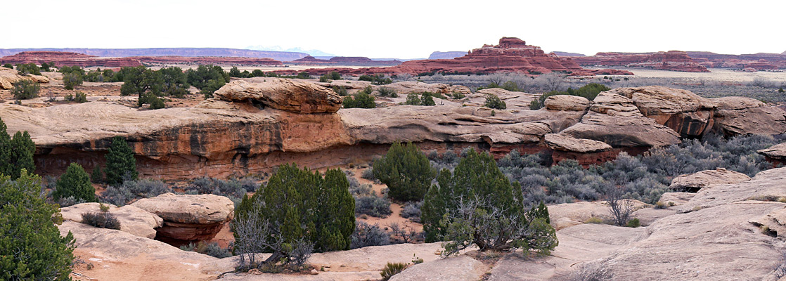
Many of the trails intersect, and a typical hike involves combining several of them, to form a loop.
See also hikes in the Island in the Sky.
The Chesler Park topographic map shows the location of the central trails.

Canyonlands National Park Trails - Short Hikes along the Park Road
Cave Spring Trail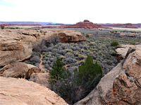 Length 0.6 miles (1 km) (loop) Elevation change 80 feet (24 meters) Trailhead End of a gravel track close to the Needles visitor center Rating (1-5) ★★★★★ The Cave Spring trail starts at the end of a spur road close to the Needles visitor center, and winds around a white sandstone plateau above the wide, bushy valley of Salt Creek. The easy route passes the spring, some pictographs, and various relics of an old cowboy camp that was inhabited from the late 1800s to about 1960. |
Pothole Point Trail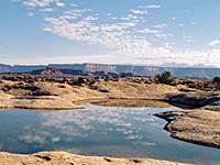 Length 0.6 miles (1 km) loop Elevation change level Trailhead Towards the west end of the park road Rating (1-5) ★★★★★ Pothole Point is renowned for its pretty reflective pools that form after rainfall, filling depressions in the flat Cedar Mesa sandstone rock. The easy, cairned path circles around a small mesa and also has good views over the Needles formations and Big Spring Canyon. If hiking right after rains there will be hundreds of potholes and pools, the largest up to 10 meters across. The holes form because of slightly softer patches in the rock, and enlarge due to erosion and acid in the accumulated rainwater. |
|
Roadside Ruin Trail Length 0.3 miles (0.5 km) (loop) Elevation change level Trailhead Near the visitor center Rating (1-5) ★★★★★ The shortest trail in the Needles begins opposite the visitor center and leads to an ancestral Puebloan granary dating from about 1200. |
Slickrock Foot Trail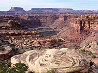 Length 2.4 miles (3.9 km) (loop) Elevation change 80 feet (24 meters) Trailhead Just before the end of road to Big Spring Canyon Overlook Rating (1-5) ★★★★★ Starting near the end of the scenic drive at Big Spring Canyon, the mostly level Slickrock Foot Trail loops around a sandstone plateau, with 4 short spurs to overlooks of Big and Little Spring canyons and excellent views across the whole Needles area towards distant mountains. |
Canyonlands Tours
Canyonlands National Park Trails - Hikes from Big Spring Canyon Overlook, at the end of the Park Road
Confluence Overlook Trail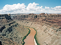 Length 5.5 miles (8.8 km) Elevation change 200 feet (61 meters) Trailhead Big Spring Canyon Overlook, at the end of the scenic drive Rating (1-5) ★★★★★ This excellent hike crosses several shallow canyons then traverses more open country, ending at a viewpoint of the junction of the Green and Colorado Rivers. The route is rather more strenuous than the average maintained NPS trail. |
Lower Big Spring Canyon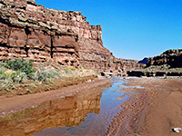 Length 5 miles (8 km) Elevation change 500 feet (152 meters) Trailhead West end of the park road Rating (1-5) ★★★★★ Cross country route down a scenic canyon to a viewpoint of the Colorado River - initially along the streambed, until it descends via some sheer dryfalls, then on a bench on the south side. |
Lower Elephant Canyon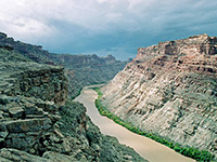 Length 5 miles (8 km) Elevation change 800 feet (244 meters) Trailhead Big Spring Canyon Overlook, at the end of the scenic drive Rating (1-5) ★★★★★ Narrow, deepening canyon that provides a route to the Colorado River; hike is along the Confluence Trail for a mile, then down the streambed, and finally across sloping terrain to a viewpoint high above the river. |
Canyonlands National Park Trails - Hikes from the Elephant Hill Trailhead
|
Big Spring Canyon-Elephant Canyon Length 11 miles (17.7 km) (loop) Elevation change 400 feet (122 meters) Trailhead Salt Flat campground Rating (1-5) ★★★★★ One of a number of possible loop hikes in the Needles, this combines the first two thirds of the route to Druid Arch with a return along other canyons to the east. The trail leaves Elephant Canyon via a side ravine then follows the far upper end of Wooden Shoe (Squaw) Canyon for a while, before crossing a pass and into Big Spring Canyon, which it follows downstream to the junction with the Druid Arch Trail and back to the Salt Flat campground. Like most hikes in this area, the trail passes a great variety of terrain, including narrow canyons, steep slopes and slickrock benches. |
|
Big Spring Canyon-Wooden Shoe (Squaw) Canyon Length 7.5 miles (12.1 km) (loop) Elevation change 350 feet (107 meters) Trailhead Salt Flat campground Rating (1-5) ★★★★★ The hike around upper Big Spring and Wooden Shoe (Squaw) canyons is the shortest loop in the Needles, with easy walking along the flat valley floors and just one strenuous part across a high pass that links the two drainages. |
Chesler Park Trail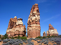 Length 3 miles (4.8 km) level overall Elevation change level Trailhead End of the Elephant Hill Access Road Rating (1-5) ★★★★★ This path passes varied terrain, across Elephant Canyon to the edge of Chesler Park - an unspoilt meadow ringed by the colorful, jagged rocks of the Needles. The first viewpoint is reached after 3 miles, from where another trail circles the edge of the meadow. One of several other routes radiating from the park is the Joint Trail, which winds southwards through cool, narrow passages between vertical rocks. |
Druid Arch Trail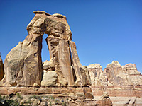 Length 5.4 miles (8.7 km) Elevation change 650 feet (198 meters) Trailhead End of the Elephant Hill Access Road Rating (1-5) ★★★★★ The double span of Druid Arch is a popular hiking destination, and is reached by the southernmost trail in the Needles, starting like several others from Elephant Hill. The route is south and later west across an open plateau, past one junction with an alternative approach from Salt Flat, then through a narrow gap into the wide streambed of Elephant Canyon. Turning south (downstream), the trail passes three more junctions (west to Chesler Park, east to upper Wooden Shoe (Squaw) Canyon and west to the Joint Trail) and ends by climbing a short ladder right at the far end of the canyon, directly below the arch. |
Peekaboo Trail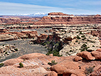 Length 5 miles (8 km) Elevation change 270 feet (82 meters) Trailhead Salt Flat campground Rating (1-5) ★★★★★ Path over grassy flats, two canyons (Wooden Shoe and Lost) and high sandstone benches, ending with a descent to the larger drainage of Salt Creek, meeting the 4WD route through that canyon, beside a spring and pictograph panel |
Red Lake Canyon Trail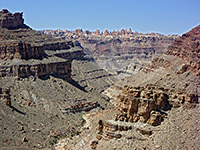 Length 9.5 miles (15.3 km) Elevation change 1600 feet (488 meters) Trailhead End of the Elephant Hill Access Road Rating (1-5) ★★★★★ The only direct route to the Colorado River in the Needles is along Lower Red Lake Canyon, 2 miles south of the confluence with the Green River. The path begins along the Devils Lane road, just east of Cyclone Canyon, a point reached either by hiking from Big Spring Canyon Overlook, or (slightly shorter) by 4WD vehicle or on foot starting from the Elephant Hill trailhead. Lower Red Lake is a deep, overgrown, rocky but quite short canyon, without any obstructions, that meets the Colorado just upstream of the start of the rapids in Cataract Canyon. The round trip to the river is normally done over 2 days. |
Wooden Shoe Canyon and Lost Canyon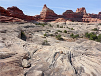 Length 8.7 miles (14 km) (loop) Elevation change 400 feet (122 meters) Trailhead Squaw Flat campground A Rating (1-5) ★★★★★ This loop hike explores two adjacent canyons that are quite different in character. If walking clockwise, the first part is the same route used to reach Peekaboo Spring, as far as Lost Canyon, where a right turn leads along this densely-vegetated, watery drainage to its upper end, then over a high ridge on the west side into Wooden Shoe (previously Squaw) Canyon, which has no stream so is much more arid and open. The Peekaboo Trail is rejoined after a 1.6 mile walk down this ravine, then the trailhead is 1.1 miles further. |
All Contents © Copyright The American Southwest | Comments and Questions | Contribute | Affiliate Marketing Disclosure | Site Map