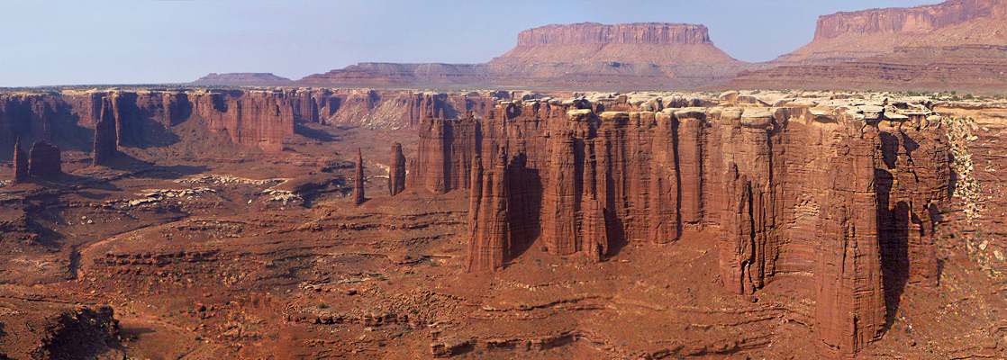
Hiking in the Island in the Sky, Canyonlands National Park
Utah > Canyonlands National Park > Island in the Sky > Hikes and Trails
See also hikes in the Needles.
Island in the Sky Trails: On the Plateau | To the Rivers
The Island in the Sky map shows the location of each trail.

Canyonlands National Park Trails - Hikes on the Plateau
Aztec Butte Trail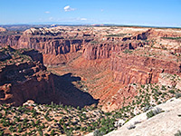 Length 1 miles (1.6 km) Elevation change 200 feet (61 meters) Trailhead Short distance along the road to Upheaval Dome Rating (1-5) ★★★★★ Aztec Butte rises 200 feet above the plateau right at the center of the Island district, just north of Willow Flat campground. The easy trail to the top passes a cliff dwelling and several ancient Anasazi granaries, some reached by short spur paths, and also has good views over Trail Canyon that starts just to the north. |
Grand View Trail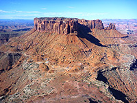 Length 1 miles (1.6 km) Elevation change level Trailhead South end of the scenic drive Rating (1-5) ★★★★★ The Grand View Trail leads from the carpark at the end of the park road to the very southern tip of the Island in the Sky plateau, at 6,265 feet, which offers a 270° panorama over the White Rim and the river canyons, the best view in the whole of Canyonlands National Park. |
Mesa Arch Trail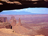 Length 0.6 miles (1 km) (loop) Elevation change level Trailhead East side of the scenic drive, near the spur road to Upheaval Dome Rating (1-5) ★★★★★ A short, easy route through pine-juniper woodland to Mesa Arch, perched on the east rim of the plateau high above the middle fork of Buck Canyon. The view through the arch, looking out towards the distant and often snow-covered La Sal Mountains, is one of the most photographed in the park, especially at sunrise. |
Murphy Point Trail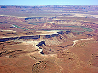 Length 1.7 miles (2.7 km) Elevation change level Trailhead Small parking area on the west side of the scenic drive Rating (1-5) ★★★★★ Murphy Point is a narrow mesa on the west side of the Island in the Sky, and can be reached by an old vehicle track, now for foot travel only, that leaves the park road a little way north of Buck Canyon Overlook. The western edge looks out over a vast area of canyons and mesas, including Soda Springs Basin, the White Rim, and Murphy Hogback - a westwards continuation of the main mesa 1,000 feet lower down. Along the track begins the 10 mile Murphy Loop Trail, which descends steeply down the south side of the point and follows the hogback, meeting a primitive campsite beside the White Rim road and returning via a parallel ravine a short distance to the south. |
| Island in the Sky Tours |
Neck Spring Trail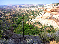 Length 5 miles (8 km) (loop) Elevation change 260 feet (79 meters) Trailhead Shafer Canyon Overlook, just south of the visitor center Rating (1-5) ★★★★★ The well used, 5 mile trail past Neck Spring starts just south of the visitor center, opposite Shafer Canyon overlook, and winds around some upper tributaries of Taylor Canyon, also passing Cabin Spring and various old cattle ranching relics. The trail has good views westwards, towards the Green River. |
Upheaval Dome Overlook Trail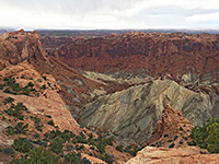 Length 1 miles (1.6 km) Elevation change 200 feet (61 meters) Trailhead Parking area at the end of a side road Rating (1-5) ★★★★★ Upheaval Dome is a large crater at the west side of the plateau, thought to result from meteoric impact. An easy trail leads to two viewpoints along the south rim, and a nearby cross-country route descends Upheaval Canyon to the Green River. |
|
Whale Rock Trail Length 0.5 miles (0.8 km) Elevation change 225 feet (69 meters) Trailhead Near Upheaval Dome Rating (1-5) ★★★★★ The short path up Whale Rock begins near the end of the road to Upheaval Dome; the route ascends the slickrock slope of a distinctively-shaped sandstone outcrop, affording good views of the edge of the dome, and adjacent Trail Canyon. |
White Rim Overlook Trail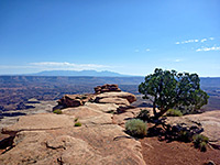 Length 0.9 miles (1.4 km) Elevation change 140 feet (43 meters) Trailhead Near the south end of the scenic drive, along a short picnic loop road Rating (1-5) ★★★★★ The White Rim can be seen from every high elevation viewpoint in the Island in the Sky, but best of all from the end of a very narrow promontory that projects eastwards, off the main plateau, a mile north of Grand View Point. The largest, flattest area of the rim is far below just to the east, while also in fine view are Monument Basin and Gooseberry Canyon. |
Canyonlands National Park Trails - Hikes to the Rivers
|
Alcove Spring Trail Length 20 miles (32.2 km) Elevation change 1700 feet (518 meters) Trailhead Along the road to Upheaval Dome Rating (1-5) ★★★★★ The longest trail in the Island in the Sky area is the route down Trail Canyon and Taylor Canyon to the Green River, starting near the end of the road to Upheaval Dome. The route switchbacks steeply down a side ravine near the head of Trail Canyon, passing below Alcove Spring nestled in a big overhang in the sandstone cliffs - a good, reliable water source - then follows the streambed downcanyon to the junction with Taylor Canyon. The remaining 10 miles are along a rough 4WD track, eventually meeting the river just north the end of the trail down Upheaval Canyon. |
Gooseberry Trail and Monument Basin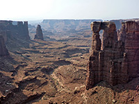 Length 4 miles (6.4 km) to Monument Basin Elevation change 1480 feet (451 meters) Trailhead Near the south end of the scenic drive, along a short picnic loop road Rating (1-5) ★★★★★ Relatively short but initially very steep path, descending from the plateau near Grand View Point then following a shallow, rocky wash to the White Rim Road, at the brink of Gooseberry Canyon. A 1.3 mile continuation hike, mostly off-trail, reaches the rim of Monument Basin, for spectacular views of its red rock buttes and spires. |
|
Lathrop Trail Length 8.5 miles (13.7 km) Elevation change 2200 feet (671 meters) Trailhead Along Island-in-the-Sky Road Rating (1-5) ★★★★★ Lathrop Canyon provides the only route from the plateau to the Colorado River, though the round trip may need one overnight stay. The path begins 1.8 miles south of the visitor center, heads southeast across the grassy plateau (Grays Pasture) to a promontory above Upper Lathrop Canyon, turns sharply west and switchbacks down the cliff face, reaching the White Rim after 5 miles. The second part of the route is along a 4WD track down the less steep lower canyon, which winds its way gently to the Colorado. |
Syncline Loop Trail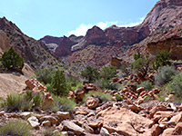 Length 8 miles (12.9 km) (loop) Elevation change 1460 feet (445 meters) Trailhead Upheaval Dome Rating (1-5) ★★★★★ Varied circuit of the two curving canyons either side of Upheaval Dome - the steep, exposed Upheaval Valley to the south and the longer, more overgrown Syncline Valley to the north, which contains a few springs. The dome itself can be seen via a separate hike, mostly along a stony streambed - up to another 4 miles. |
Wilhite Trail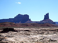 Length 5 miles (8 km) Elevation change 1600 feet (488 meters) Trailhead Small parking area along Upheaval Dome Road Rating (1-5) ★★★★★ The Wilhite Trail is another that descends the sheer Wingate Cliffs that encircle the Island-in-the Sky, then follows a shallow, red rock canyon to the White Rim road. The route begins half way along the spur road to Upheaval Dome, at first crossing brush-covered flat land at the edge of the mesa, before descending 1,000 feet quite steeply down a narrow ravine into Holeman Spring Basin. The path then follows a streamway through the wide, open basin, joining the White Rim road about half a mile from the Green River. On the far side of the road the Holeman Spring drainage forms a short slot canyon, though a sheer pour-off prevents continuing all the way to the river. |
All Contents © Copyright The American Southwest | Comments and Questions | Contribute | Affiliate Marketing Disclosure | Site Map