Syncline Loop Trail, Canyonlands National Park
Utah > Canyonlands National Park > Island in the Sky > Hiking > Syncline Loop Trail
Syncline Loop Trail
Varied circuit of the two curving canyons either side of Upheaval Dome - the steep, exposed Upheaval Valley to the south and the longer, more overgrown Syncline Valley to the north, which contains a few springs. The dome itself can be seen via a separate hike, along a stony streambed
Length: 8 miles (round trip), plus up to 2 miles (one way) to the dome
Elevation change: 1,460 feet
Difficulty: Strenuous
Type: Loop, with spur to the dome
Usage: Low
Season: Spring, summer, fall - very hot in summer, though water should be available in several places
Trailhead: Upheaval Dome
Rating (1-5): ★★★★★
Elevation change: 1,460 feet
Difficulty: Strenuous
Type: Loop, with spur to the dome
Usage: Low
Season: Spring, summer, fall - very hot in summer, though water should be available in several places
Trailhead: Upheaval Dome
Rating (1-5): ★★★★★

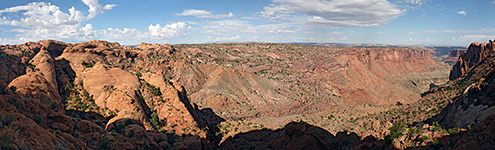
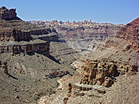
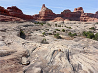
The circular formation of Upheaval Dome, thought to result from a meteorite impact, is one of the most popular attractions of the Island in the Sky in Canyonlands National Park, and may be viewed from the rim along a short path. A rough, unofficial trail descends to the center of the dome, but the usual way to see more of this area is by the 8 mile Syncline Loop Trail, which follows the two curving canyons that encircle the outside of the elevated area. The route is well enough marked, though not often traveled and quite strenuous in places, descending 1,640 feet to the mouth of the canyon at the entrance to the dome, then rising again on the return leg.
Clockwise is the recommended direction, since then the elevation gain is generally less steep and done in somewhat more shady conditions, and the uphill section is more likely to contain drinkable water. In this direction, the path starts off level for a mile then descends into Upheaval Valley, dropping down in two main stages and after 3 miles reaching the junction with the other canyon (Syncline Valley), where the Upheaval Canyon Trail continues downstream, and the Syncline Loop ascends up the valley, which has one steep part, followed by an overgrown stretch containing a major spring and finally a much shallower ravine, extending another 3 miles all the way back to the trailhead.
The interior of the dome can be seen via a spur trail which follows the exit drainage for 1.5 miles, past the inner ring of ridges, to the rounded center, where the wash splits several times, and although there is no single spectacular overlook, good views abound all directions. The round trip to the middle of the dome is about 4 miles hence the total distance is 12 miles, a hike taking at least seven hours, and maybe up to ten hours. Apart from some distant views near the start, all of the route is within canyons so the views are somewhat limited but still varied, as the ravines alternate between open and bushy, wide and narrow, straight and bendy, dry and (sometimes) moist; only the shallow, eastern section is more monotonous.
Overview map of the Island in the Sky; topographic map of the Syncline Loop Trail.
33 views along the Syncline Loop Trail.
The trailhead is the same as for the Upheaval Dome Overlook, at the end of a paved spur road. The path starts on the north side of the parking lot, and divides after a few feet - the overlook is right, Syncline Loop left, marked by a notice warning that the route is strenuous and difficult to follow.
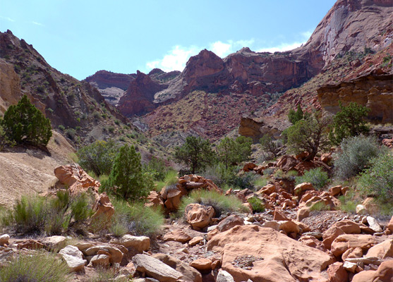
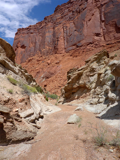
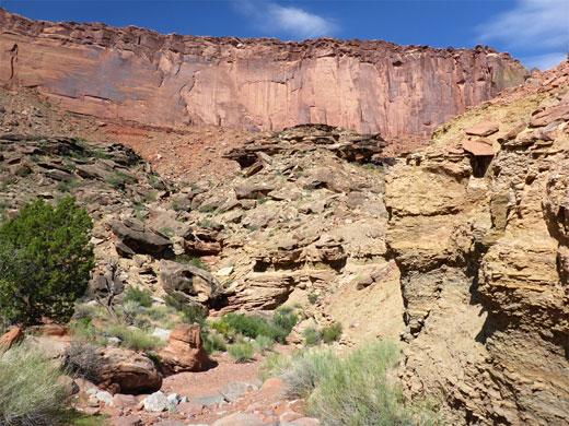
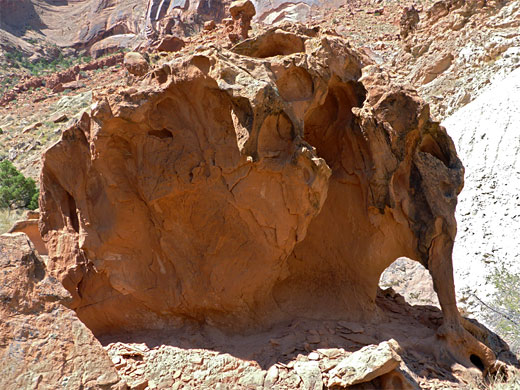
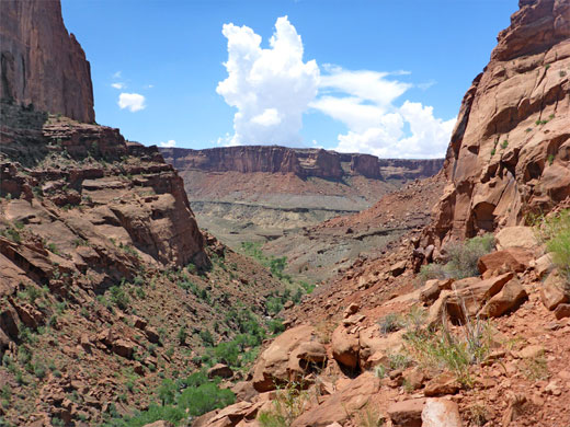
The path rises slightly, traversing jumbled land of angular boulders, pine and juniper trees and dark red sand, then is almost level, until a small descent of a little ravine with more boulders, which leads to the rim of Upheaval Valley. The upper end is lined by undulating, pale-orange Navajo sandstone below which are vertical, red Wingate cliffs, extending 4.5 miles westwards to the Green River. The lower part, below the conference with Syncline Valley, is Upheaval Canyon. The route now makes a big descent, via tight switchbacks; first winding down the upper section of the cliffs to a briefly flatter area on the north side of the drainage and then on to a notch in a ridge above the shorter second stage, all the way to the streambed, this already 1,100 feet below the rim. From here, the canyon junction is 1.4 miles away; an easy walk mostly right along the creekbed, which is usually dry, covered by a mix of rocks, pebbles and firm sand; in a few places the path rises to cut off bends and minor obstacles. This section is often hot, shielded from the wind, lacking shady trees and formed of dusty, crumbling, light-colored rocks, of the Moenkopi Formation.
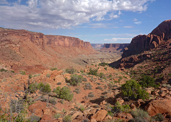
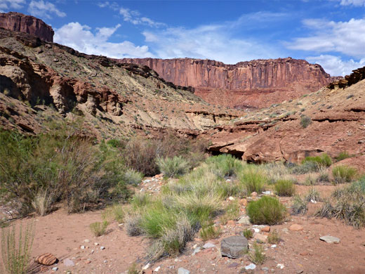
Low cliffs form on one side or the other as the confluence approaches, where the trail divides. At the junction, a sign gives the distance to the Green River as 3 miles, along the Upheaval Canyon Trail; the Syncline Loop continues along the right branch, round a bend to another canyon junction, with Syncline Valley and the drainage from Upheaval Dome, this latter soon blocked by a pour-off. The path climbs a slope to a plateau between these two streambeds, site of the primitive Syncline Campground, the only location along the loop where overnight stays are permitted. Just beyond is the junction with the Upheaval Dome spur trail, distance 1.5 miles.
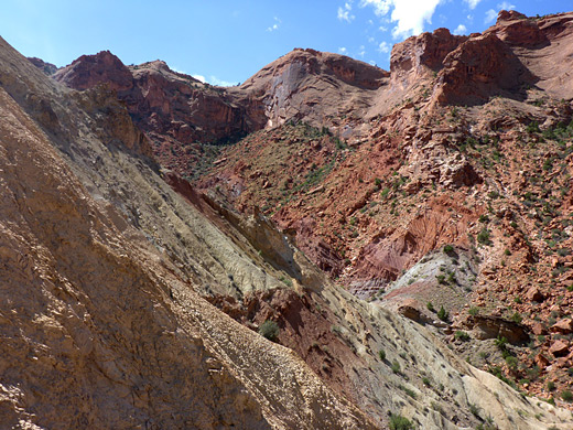
The spur path soon descends to the drainage and follows its wide, flat floor upstream, round a few bends and then along a straight, followed by another curve containing a seep that might produce enough water for drinking, and on to a small pour-off, passed on the south side. Above here the drainage becomes a little more enclosed, and the rocks change color from red to grey and white, as the inside of the dome approaches. The streambed splits, and the official path ends a short distance along the north fork, though either branch can be followed for another half mile or so, past junctions with other tributaries. The south fork runs beneath the highest part of the rim, directly below the overlook, and gives the best views of the rocks. This drainage also contains a minor seep. Climbing the loose, steep, earthen slopes in the center of the dome is possible in some places, for a better overall perspective of the scenery.
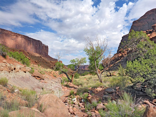
Back at the junction, the return distance to the trailhead is 5 miles, along Syncline Valley, round the north and east sides of the dome. The trail starts along a wide, flat-floored canyon, which narrows gradually and starts to gain height after a while; initially rising above the stream and coming close again as the ground levels and the streambed continues to ascend. The path passes just above a seasonal spring that creates a tiny travertine fall, the waters dropping 3 feet into a pool; later, the route crosses the main streambed above another, larger pool, now nearing the head of the lower section of the valley, above which the land rises abruptly by about 400 feet. The trail climbs steeply, moving to the west then to the north of a big pour-off, and meanders round, over and sometimes under many huge, jumbled boulders, the course in places marked with arrow signs as the way ahead is not always obvious.
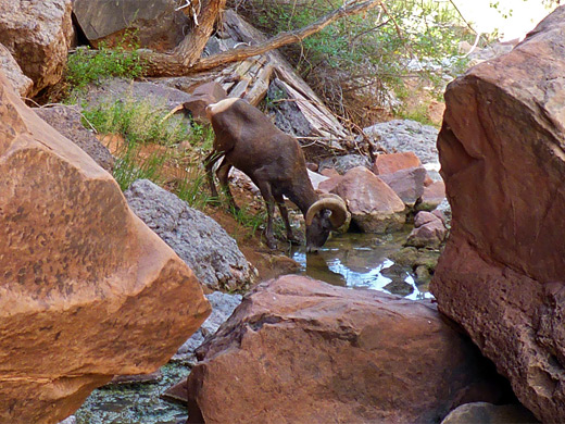
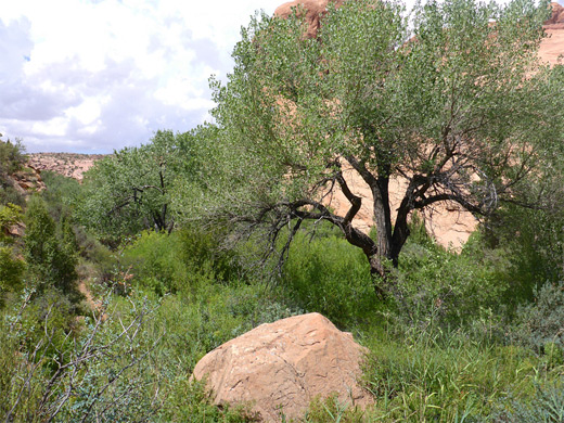
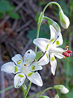
Past here the trail comes down to the streambed, and this is followed, nearly level for a while, until the path moves away across a grassy flat to the south and on to more overgrown surroundings, with cottonwood trees, reeds and bamboo. A short spur leads southwards to a stream, a shallow pool and a spring, this in a huge, overhanging, mossy alcove, its entrance shielded by more big trees which, together with the north-facing aspect, ensure that the sun never shines here. Growing around the spring are two rare plants, alcove bog orchid and sheathed false deathcamas.
The onwards trail continues through overgrown surroundings for another half mile, extending to a fork in the canyon; the eastern branch soon ends below a high dryfall while the trail follows the main branch, southwards. For a thousand feet this is narrow, enclosed on both sides by sheer Wingate cliffs, which open abruptly to a wider gorge, gaining height steadily, now dry and much less vegetated. There are several short, steep climbs, one over a big sloping slab, until the drainage, now shallow, becomes fairly level once more and is little changing for the final 2 miles, rounding minor bends to reveal a another quarter mile or so of identical scenery - bushes, boulders and sand - bordered by Navajo sandstone domes on the right side, lining the dome, and ledgy, inclined ridges to the left. The end of the canyon is not so obvious until close-up; noise of traffic is often heard some distance before.
Clockwise is the recommended direction, since then the elevation gain is generally less steep and done in somewhat more shady conditions, and the uphill section is more likely to contain drinkable water. In this direction, the path starts off level for a mile then descends into Upheaval Valley, dropping down in two main stages and after 3 miles reaching the junction with the other canyon (Syncline Valley), where the Upheaval Canyon Trail continues downstream, and the Syncline Loop ascends up the valley, which has one steep part, followed by an overgrown stretch containing a major spring and finally a much shallower ravine, extending another 3 miles all the way back to the trailhead.
The interior of the dome can be seen via a spur trail which follows the exit drainage for 1.5 miles, past the inner ring of ridges, to the rounded center, where the wash splits several times, and although there is no single spectacular overlook, good views abound all directions. The round trip to the middle of the dome is about 4 miles hence the total distance is 12 miles, a hike taking at least seven hours, and maybe up to ten hours. Apart from some distant views near the start, all of the route is within canyons so the views are somewhat limited but still varied, as the ravines alternate between open and bushy, wide and narrow, straight and bendy, dry and (sometimes) moist; only the shallow, eastern section is more monotonous.
Maps
Overview map of the Island in the Sky; topographic map of the Syncline Loop Trail.
Photographs
33 views along the Syncline Loop Trail.
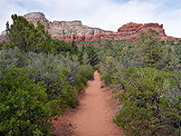
Syncline Loop Trailhead
The trailhead is the same as for the Upheaval Dome Overlook, at the end of a paved spur road. The path starts on the north side of the parking lot, and divides after a few feet - the overlook is right, Syncline Loop left, marked by a notice warning that the route is strenuous and difficult to follow.
Upheaval Valley
The path rises slightly, traversing jumbled land of angular boulders, pine and juniper trees and dark red sand, then is almost level, until a small descent of a little ravine with more boulders, which leads to the rim of Upheaval Valley. The upper end is lined by undulating, pale-orange Navajo sandstone below which are vertical, red Wingate cliffs, extending 4.5 miles westwards to the Green River. The lower part, below the conference with Syncline Valley, is Upheaval Canyon. The route now makes a big descent, via tight switchbacks; first winding down the upper section of the cliffs to a briefly flatter area on the north side of the drainage and then on to a notch in a ridge above the shorter second stage, all the way to the streambed, this already 1,100 feet below the rim. From here, the canyon junction is 1.4 miles away; an easy walk mostly right along the creekbed, which is usually dry, covered by a mix of rocks, pebbles and firm sand; in a few places the path rises to cut off bends and minor obstacles. This section is often hot, shielded from the wind, lacking shady trees and formed of dusty, crumbling, light-colored rocks, of the Moenkopi Formation.
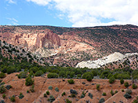
Canyon Junction
Low cliffs form on one side or the other as the confluence approaches, where the trail divides. At the junction, a sign gives the distance to the Green River as 3 miles, along the Upheaval Canyon Trail; the Syncline Loop continues along the right branch, round a bend to another canyon junction, with Syncline Valley and the drainage from Upheaval Dome, this latter soon blocked by a pour-off. The path climbs a slope to a plateau between these two streambeds, site of the primitive Syncline Campground, the only location along the loop where overnight stays are permitted. Just beyond is the junction with the Upheaval Dome spur trail, distance 1.5 miles.
Spur Trail to Upheaval Dome
The spur path soon descends to the drainage and follows its wide, flat floor upstream, round a few bends and then along a straight, followed by another curve containing a seep that might produce enough water for drinking, and on to a small pour-off, passed on the south side. Above here the drainage becomes a little more enclosed, and the rocks change color from red to grey and white, as the inside of the dome approaches. The streambed splits, and the official path ends a short distance along the north fork, though either branch can be followed for another half mile or so, past junctions with other tributaries. The south fork runs beneath the highest part of the rim, directly below the overlook, and gives the best views of the rocks. This drainage also contains a minor seep. Climbing the loose, steep, earthen slopes in the center of the dome is possible in some places, for a better overall perspective of the scenery.

Lower Section of Syncline Valley
Back at the junction, the return distance to the trailhead is 5 miles, along Syncline Valley, round the north and east sides of the dome. The trail starts along a wide, flat-floored canyon, which narrows gradually and starts to gain height after a while; initially rising above the stream and coming close again as the ground levels and the streambed continues to ascend. The path passes just above a seasonal spring that creates a tiny travertine fall, the waters dropping 3 feet into a pool; later, the route crosses the main streambed above another, larger pool, now nearing the head of the lower section of the valley, above which the land rises abruptly by about 400 feet. The trail climbs steeply, moving to the west then to the north of a big pour-off, and meanders round, over and sometimes under many huge, jumbled boulders, the course in places marked with arrow signs as the way ahead is not always obvious.

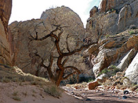
Pool and Spring
Past here the trail comes down to the streambed, and this is followed, nearly level for a while, until the path moves away across a grassy flat to the south and on to more overgrown surroundings, with cottonwood trees, reeds and bamboo. A short spur leads southwards to a stream, a shallow pool and a spring, this in a huge, overhanging, mossy alcove, its entrance shielded by more big trees which, together with the north-facing aspect, ensure that the sun never shines here. Growing around the spring are two rare plants, alcove bog orchid and sheathed false deathcamas.
Upper Section of Syncline Valley
The onwards trail continues through overgrown surroundings for another half mile, extending to a fork in the canyon; the eastern branch soon ends below a high dryfall while the trail follows the main branch, southwards. For a thousand feet this is narrow, enclosed on both sides by sheer Wingate cliffs, which open abruptly to a wider gorge, gaining height steadily, now dry and much less vegetated. There are several short, steep climbs, one over a big sloping slab, until the drainage, now shallow, becomes fairly level once more and is little changing for the final 2 miles, rounding minor bends to reveal a another quarter mile or so of identical scenery - bushes, boulders and sand - bordered by Navajo sandstone domes on the right side, lining the dome, and ledgy, inclined ridges to the left. The end of the canyon is not so obvious until close-up; noise of traffic is often heard some distance before.
Syncline Loop Wildflowers
More flowers along the trail
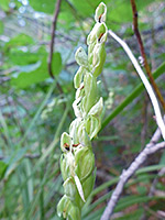
 Sheathed false deathcamas |
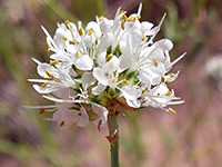 White prairie clover |
 Alcove bog orchid |
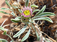 Annual Townsend daisy |
More flowers along the trail
Syncline Loop Trail - Similar Hikes
All Contents © Copyright The American Southwest | Comments and Questions | Contribute | Affiliate Marketing Disclosure | Site Map