Wilhite Trail, Canyonlands National Park
Utah > Canyonlands National Park > Island in the Sky > Hiking > Wilhite Trail
Wilhite Trail
Route down the sheer Wingate cliffs on the west side of the Island in the Sky, then across flatter land of small ravines and ridges to the White Rim Road, from where the Green River is a short distance further west. Also nearby is Holeman Slot, a short slot canyon
Length: 5 miles, to the White Rim Road
Elevation change: 1,600 feet
Difficulty: Moderate to strenuous
Type: One way. Continuation hikes possible along the White Rim Road
Usage: Low
Season: All year, though summers are very hot
Trailhead: Small parking area along Upheaval Dome Road
Rating (1-5): ★★★★★
Elevation change: 1,600 feet
Difficulty: Moderate to strenuous
Type: One way. Continuation hikes possible along the White Rim Road
Usage: Low
Season: All year, though summers are very hot
Trailhead: Small parking area along Upheaval Dome Road
Rating (1-5): ★★★★★

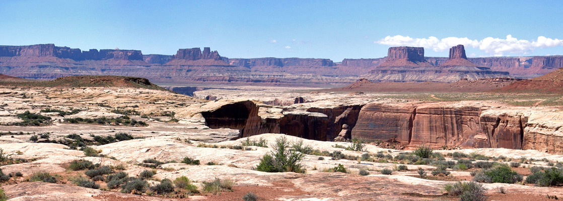
There are five recognized hiking routes that descend from the Island in the Sky plateau in Canyonlands National Park, of which the Wilhite Trail is intermediate in both distance (5 miles) and elevation change (1,600 feet), but is amongst the least traveled and most scenic - after a brief traverse of the bushy mesa top, the path drops steeply down the Wingate sandstone cliffs then follows a shallow, red rock ravine to the White Rim Road, just as the drainage (Holeman Spring Creek) forms a short slot canyon.
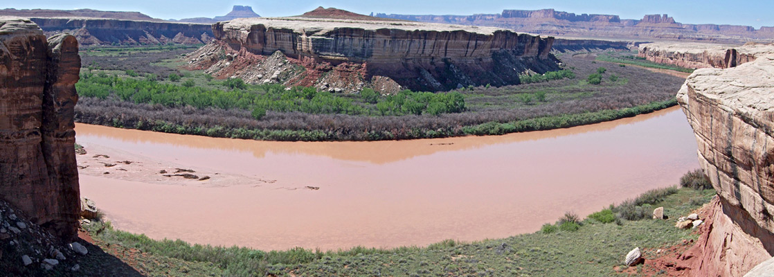
Although a sheer dryfall prevents walking all the way to the Green River, this can be seen by walking westwards along the road for 1.5 miles, to quite a dramatic viewpoint, as the river flows around a wide U-bend at Valentine Bottom. There are no water sources anywhere along the Wilhite Trail, and the majority is across open desert land lacking any shade, so the hike is best attempted during the cooler months.
Overview map of the Island in the Sky; topographic map of the Wilhite Trail.
10 views along the Wilhite Trail.
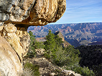
The rather inconspicuous trailhead is 2 miles along the road to Upheaval Dome, at a small pullout overlooking bushy flats to the south. The narrow, cairned path crosses the plateau, past slickrock and sand dunes that are covered by pinyon pine, juniper, opuntia and other cacti, then climbs slightly to a ridge which gives the first view of the distant lands ahead. The route continues down the far side, over more level ground and around a shallow basin to the plateau edge, above a narrow, V-shaped ravine - in shade during early morning and late afternoon - that is filled with big boulders but provides a straightforward way down. Again cairns mark the route, which has switchbacks in some places and at others is steeper, angling directly down the slope. The first part of the descent is through the thick Wingate sandstone layer, followed by a more gradual drop through the bouldery hillside below, at the top of the Chinle Formation.
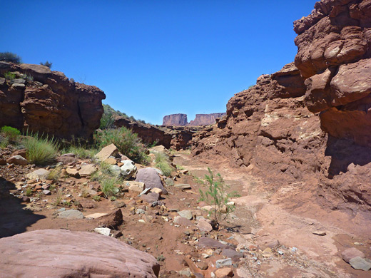
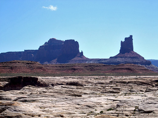
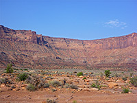
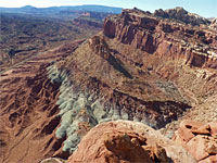
The path flattens out for a while, curving beneath a Wingate promontory, until the land begins to slope down again, descending another 250 feet over a hillside of jumbled rocks to the main valley floor, formed of reddish sandy mounds and branched dry washes. The route soon drops into one of the shallow ravines - an upper tributary of Holeman Spring Creek - which is then followed for 2 miles to the White Rim Road. Several other branches join on both sides, and the cairns, although present, are not always obvious, so care is needed to locate the correct route when returning. The drainage becomes somewhat confined in the middle, enclosed by 20 foot high cliffs but is generally quite open, with sloping sides, and allows good views across Holeman Spring Basin to the red buttes and pinnacles all around; most prominent are Steer Mesa to the north and Candlestick Tower, a tall pinnacle to the south. Towards the lower end of the wash, walking is easier on the flat land just north, rather than along the wide, stony streambed.
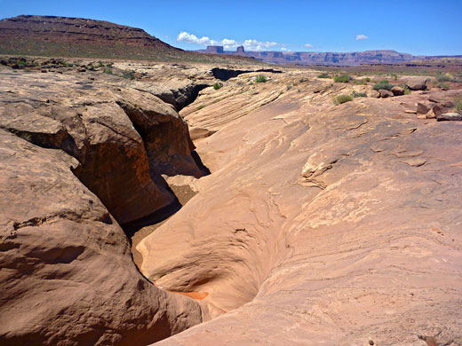
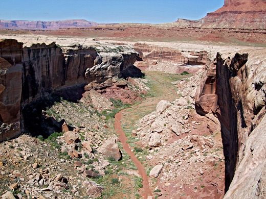
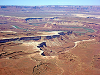
The Wilhite Trail meets the White Rim Road near the edge of plateau, in the middle of a flat expanse of white slickrock marked with many potholes which retain water after recent rainfall. On the far side of the track, the drainage soon enters a shallow, twisting slot with about 600 feet of scenic, orange/red passageways before a sheer drop off into a vertical-walled box canyon that leads to the Green River. The river itself is not in view hereabouts; the nearest good viewpoint is 1.5 miles west along the road then a short distance across slickrock and ledges to the rim of the 80 foot cliffs of white sandstone that border the waters. This point is opposite Valentine Bottom in Stillwater Canyon, where the river flows around a big bend, within a corridor of bushes and trees. Beyond are more ravines, backed by a long escarpment (Orange Cliffs), within the adjacent Glen Canyon Recreation Area.
Although a sheer dryfall prevents walking all the way to the Green River, this can be seen by walking westwards along the road for 1.5 miles, to quite a dramatic viewpoint, as the river flows around a wide U-bend at Valentine Bottom. There are no water sources anywhere along the Wilhite Trail, and the majority is across open desert land lacking any shade, so the hike is best attempted during the cooler months.
Maps
Overview map of the Island in the Sky; topographic map of the Wilhite Trail.
Photographs
10 views along the Wilhite Trail.
Start of the Wilhite Trail
The rather inconspicuous trailhead is 2 miles along the road to Upheaval Dome, at a small pullout overlooking bushy flats to the south. The narrow, cairned path crosses the plateau, past slickrock and sand dunes that are covered by pinyon pine, juniper, opuntia and other cacti, then climbs slightly to a ridge which gives the first view of the distant lands ahead. The route continues down the far side, over more level ground and around a shallow basin to the plateau edge, above a narrow, V-shaped ravine - in shade during early morning and late afternoon - that is filled with big boulders but provides a straightforward way down. Again cairns mark the route, which has switchbacks in some places and at others is steeper, angling directly down the slope. The first part of the descent is through the thick Wingate sandstone layer, followed by a more gradual drop through the bouldery hillside below, at the top of the Chinle Formation.
Holeman Spring Basin
The path flattens out for a while, curving beneath a Wingate promontory, until the land begins to slope down again, descending another 250 feet over a hillside of jumbled rocks to the main valley floor, formed of reddish sandy mounds and branched dry washes. The route soon drops into one of the shallow ravines - an upper tributary of Holeman Spring Creek - which is then followed for 2 miles to the White Rim Road. Several other branches join on both sides, and the cairns, although present, are not always obvious, so care is needed to locate the correct route when returning. The drainage becomes somewhat confined in the middle, enclosed by 20 foot high cliffs but is generally quite open, with sloping sides, and allows good views across Holeman Spring Basin to the red buttes and pinnacles all around; most prominent are Steer Mesa to the north and Candlestick Tower, a tall pinnacle to the south. Towards the lower end of the wash, walking is easier on the flat land just north, rather than along the wide, stony streambed.
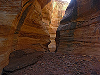
The White Rim
The Wilhite Trail meets the White Rim Road near the edge of plateau, in the middle of a flat expanse of white slickrock marked with many potholes which retain water after recent rainfall. On the far side of the track, the drainage soon enters a shallow, twisting slot with about 600 feet of scenic, orange/red passageways before a sheer drop off into a vertical-walled box canyon that leads to the Green River. The river itself is not in view hereabouts; the nearest good viewpoint is 1.5 miles west along the road then a short distance across slickrock and ledges to the rim of the 80 foot cliffs of white sandstone that border the waters. This point is opposite Valentine Bottom in Stillwater Canyon, where the river flows around a big bend, within a corridor of bushes and trees. Beyond are more ravines, backed by a long escarpment (Orange Cliffs), within the adjacent Glen Canyon Recreation Area.
Wilhite Trail - Similar Hikes
All Contents © Copyright The American Southwest | Comments and Questions | Contribute | Affiliate Marketing Disclosure | Site Map