Delicate Arch Trail, Arches National Park
Utah > Arches National Park > Hiking > Delicate Arch Trail
Delicate Arch Trail
The most famous feature in Arches National Park is reached by a popular trail that starts over sandy ground then climbs more steeply up rocky slopes to the edge of a sandstone bowl next to the arch. The base of the arch can be reached by walking a short distance over the slickrock
Length: 1.5 miles
Elevation change: 480 feet
Difficulty: Easy to moderate
Type: One way
Usage: High
Season: All year; hot and exposed in summer
Trailhead: Along the side road to Wolfe Ranch
Rating (1-5): ★★★★★
Elevation change: 480 feet
Difficulty: Easy to moderate
Type: One way
Usage: High
Season: All year; hot and exposed in summer
Trailhead: Along the side road to Wolfe Ranch
Rating (1-5): ★★★★★

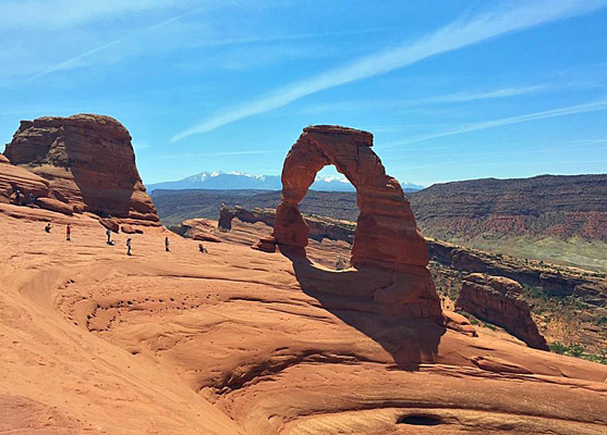
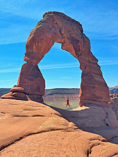
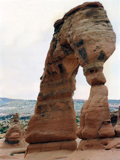
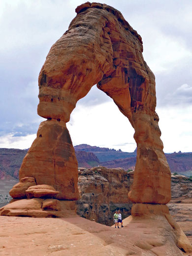
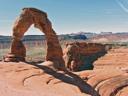
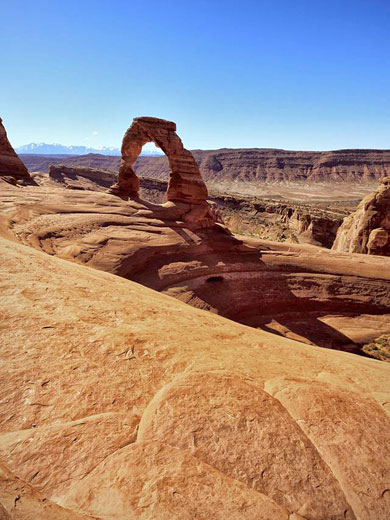
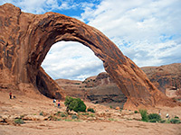
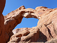
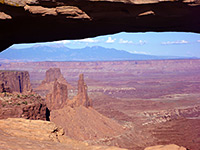
Delicate Arch is the most famous feature in Arches National Park, and the most recognizable arch in the Southwest, prominently positioned on top of a narrow ridge, overlooking a smooth slickrock bowl, with a scenic backdrop provided by the distant La Sal Mountains. Unlike most of the big arches in the park, the span is relatively far from the main road, reachable by a very popular 1.5 mile trail that crosses sandy flats and exposed sandstone, and ends (officially) at a viewpoint 250 feet away on the north side of the sandstone basin, though most people scramble over the sloping slickrock right to the base of the arch.
All of the trail lacks shade, and some parts are potentially slippery, especially after rainfall, but there are no major difficulties. The views are good all along the route, while other attractions are remains of an old homestead (Wolfe Ranch), and a panel of ancient Ute petroglyphs. For those not wanting to walk the 3 mile round trip, the arch can be viewed by a much shorter path of 0.25 miles, still rather steep, which leads to an overlook at the edge of the quite deep canyon of Winter Camp Wash; from here, the arch is a quarter of a mile north, on the far side of the ravine.
Arches overview map.
16 views of Delicate Arch.
Not surprisingly for such a popular hike, the Delicate Arch Trail is served by an extra-large parking area (expanded in 2015), with space for over a hundred vehicles - on both sides of the approach road, which is a spur off the main park drive. The road continues east a short distance, over the wide drainage of Salt Wash, before ending at the lesser trailhead for the Delicate Arch Viewpoint Trail. The main trailhead has rest rooms but no drinking water.
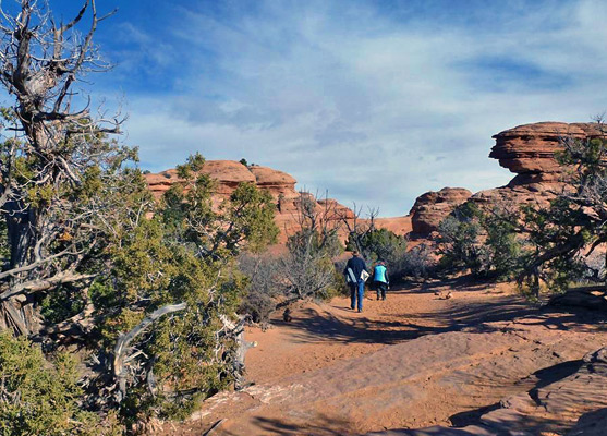
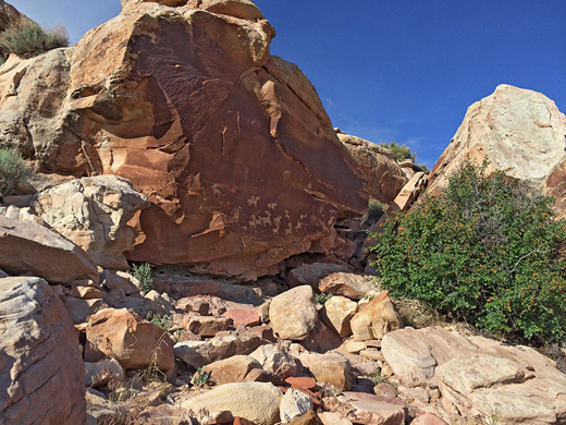
The first point of interest, just 350 feet down the path, is Wolfe Ranch, established here in the late 1800s by John Wesley Wolfe and his eldest son Fred. The place was sold in 1910 and eventually acquired by the government; visible today are two wooden cabins, a corral, a wagon and several pieces of farm equipment. After the ranch, the wide, well travelled path crosses Salt Wash on two footbridges, and a short spur forks off to the left (north), leading to the Wolfe Ranch petroglyph panel, a group of bighorn sheep and horses etched into a dark sandstone cliff overlooking a tributary of the creek. The spur returns to the main trail just as it climbs to a low plateau bordering the creek to the east, and continues across level, sandy, reddish terrain, crossing a minor drainage and then veering north to pass a somewhat deeper wash, its streamway lined with grass and bushes.
Beyond, the ground starts to slope upwards - still sand for a short distance then bare rock, where the route is marked by cairns. The ascent is quite gradual, moving up to another small drainage, which is then followed northwards for a quarter of a mile, until just beyond a line of cliffs, where the path turns due east, along the base of the cliffs to the arch viewpoint. For a short distance the route runs along a narrow ledge, the land falling away to the north to a sandy depression. The arch is hidden by the cliffs until quite close, making its eventual appearance all the more dramatic. On some days there may be several hundred people around the arch and the end of the trail, often queuing in order to take photographs; it can be difficult to picture the formation without any hikers. The formation is angled northeast-southwest, so when viewed from the end of the trail (north) is in shadow for most of the day; the best times for photography are in late afternoon and evening, when the setting sun illuminates the span and enhances the redness of the rocks.
All of the trail lacks shade, and some parts are potentially slippery, especially after rainfall, but there are no major difficulties. The views are good all along the route, while other attractions are remains of an old homestead (Wolfe Ranch), and a panel of ancient Ute petroglyphs. For those not wanting to walk the 3 mile round trip, the arch can be viewed by a much shorter path of 0.25 miles, still rather steep, which leads to an overlook at the edge of the quite deep canyon of Winter Camp Wash; from here, the arch is a quarter of a mile north, on the far side of the ravine.
Location
Arches overview map.
Photographs
16 views of Delicate Arch.
Delicate Arch Trailhead
Not surprisingly for such a popular hike, the Delicate Arch Trail is served by an extra-large parking area (expanded in 2015), with space for over a hundred vehicles - on both sides of the approach road, which is a spur off the main park drive. The road continues east a short distance, over the wide drainage of Salt Wash, before ending at the lesser trailhead for the Delicate Arch Viewpoint Trail. The main trailhead has rest rooms but no drinking water.
The Trail
The first point of interest, just 350 feet down the path, is Wolfe Ranch, established here in the late 1800s by John Wesley Wolfe and his eldest son Fred. The place was sold in 1910 and eventually acquired by the government; visible today are two wooden cabins, a corral, a wagon and several pieces of farm equipment. After the ranch, the wide, well travelled path crosses Salt Wash on two footbridges, and a short spur forks off to the left (north), leading to the Wolfe Ranch petroglyph panel, a group of bighorn sheep and horses etched into a dark sandstone cliff overlooking a tributary of the creek. The spur returns to the main trail just as it climbs to a low plateau bordering the creek to the east, and continues across level, sandy, reddish terrain, crossing a minor drainage and then veering north to pass a somewhat deeper wash, its streamway lined with grass and bushes.
The Arch
Beyond, the ground starts to slope upwards - still sand for a short distance then bare rock, where the route is marked by cairns. The ascent is quite gradual, moving up to another small drainage, which is then followed northwards for a quarter of a mile, until just beyond a line of cliffs, where the path turns due east, along the base of the cliffs to the arch viewpoint. For a short distance the route runs along a narrow ledge, the land falling away to the north to a sandy depression. The arch is hidden by the cliffs until quite close, making its eventual appearance all the more dramatic. On some days there may be several hundred people around the arch and the end of the trail, often queuing in order to take photographs; it can be difficult to picture the formation without any hikers. The formation is angled northeast-southwest, so when viewed from the end of the trail (north) is in shadow for most of the day; the best times for photography are in late afternoon and evening, when the setting sun illuminates the span and enhances the redness of the rocks.
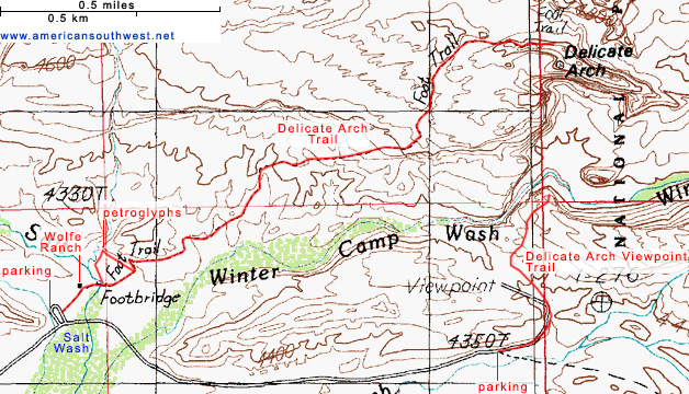
Delicate Arch Trail Map
Delicate Arch Trail - Similar Hikes
All Contents © Copyright The American Southwest | Comments and Questions | Contribute | Affiliate Marketing Disclosure | Site Map