See the Arches map for hike locations - identified by the number.

Arches National Park Trails
1. Balanced Rock Trail Length 0.4 miles (0.6 km) (loop) Elevation change level Trailhead Parking area along the scenic drive Rating (1-5) ★★★★★ Balanced Rock is a sandstone boulder perched on a column of softer rock, beside the turn-off for the road to the Windows section. Although easily seen from the highway, a short trail loops around the formation for a closer view. |
2. Broken Arch Trail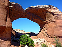 Length 1.4 miles (2.3 km) loop Elevation change level Trailhead Devils Garden campground Rating (1-5) ★★★★★ Starting from Devils Garden campground (site number 40) near the north end of the scenic drive, the loop path to Broken Arch also passes close to Tapestry Arch, and encounters varied scenery of rock, sand and bushes. Both spans may also been seen via a longer (2.5 mile) loop hike starting from the trailhead for Sand Dune Arch. |
3. Courthouse Wash Rock Art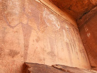 Length 0.5 miles (0.8 km) loop Elevation change 60 feet (18 meters) Trailhead Along US 191 Rating (1-5) ★★★★★ Large panel of pictographs, and some petroglyphs, in an alcove overlooking the Colorado River, along the south edge of the national park. Damaged and faded, though still impressive. |
4. Delicate Arch Trail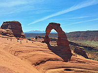 Length 1.5 miles (2.4 km) Elevation change 480 feet (146 meters) Trailhead Along the side road to Wolf Ranch Rating (1-5) ★★★★★ The most famous feature in the park is reached by a popular trail that starts over sandy ground then climbs more steeply up rocky slopes to the edge of a sandstone bowl next to the arch. The base of the arch can be reached by walking a short distance over the slickrock. |
5. Delicate Arch Viewpoint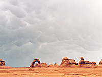 Length 0.25 miles (0.4 km) Elevation change 200 feet (61 meters) Trailhead End Wolfe Ranch Road Rating (1-5) ★★★★★ For those not hiking all the way to Delicate Arch, a path to the south starts at the end of Wolfe Ranch Road and ascends moderately steeply to a viewpoint at the edge of the canyon of Winter Camp Wash, on the far side of which is the arch - about half a mile away above a sheer sandstone cliff streaked with desert varnish. |
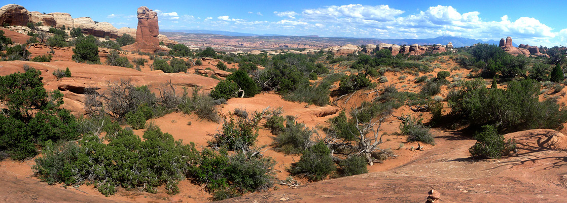
6. Devils Garden Trail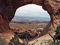 Length 7.5 miles (12.1 km) loop; level overall Elevation change level Trailhead North end of the scenic drive Rating (1-5) ★★★★★ The longest trail in Arches National Park winds across slickrock and sand dunes through the largest area of arches situated away from the main road. The first 0.8 miles is graveled, and passes several large arches including Landscape, which has the widest span of all. Beyond here the route is a little rougher, and much less traveled. |
7. Double Arch Trail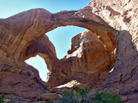 Length 0.25 miles (0.4 km) Elevation change level Trailhead Side road to the Windows Section Rating (1-5) ★★★★★ As with most paths in the national park, the trail to the twin spans of Double Arch in the Windows section is quick and easy, starting from the parking area at the end of the spur road, and reaching the arch after a level walk through bushy, sandy land beneath the cliffs. |
| Arches Tours |
8. Herdina Park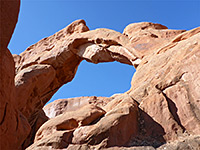 Length 4 miles (6.4 km) loop, circling all around the formations Elevation change 250 feet (76 meters) Trailhead Along a rough track forking off Road 378, west of Balanced Rock Rating (1-5) ★★★★★ Isolated group of fins and ravines containing two major arches (Leaping Arch and Eye of the Whale), reached by a 4WD track. An unofficial, half mile trail leads to the arches, while more of the area can be seen by cross-country hiking, walking all around the edge of the formations. |
9. Park Avenue Trail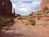 Length 1 miles (1.6 km) Elevation change 320 feet (98 meters) Trailhead Near the west end of the scenic drive Rating (1-5) ★★★★★ A popular route through a short canyon framed by red sandstone fins and pinnacles, containing a rocky streambed that may have pools or even flowing water. Passes close to several famous landmarks including The Organ and the Three Gossips. Each end of the route has a parking area, adjacent to the park road. |
10. Sand Dune Arch Trail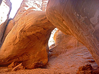 Length 0.2 miles (0.3 km) Elevation change level Trailhead Towards the north end of the scenic drive Rating (1-5) ★★★★★ Sand Dune is a somewhat hidden arch at the north edge of the Fiery Furnace region, reached by a short spur trail leading off the loop path to Broken Arch. |
11. Skyline Arch Trail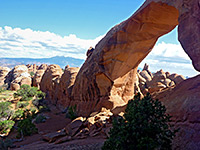 Length 0.2 miles (0.3 km) Elevation change level Trailhead Near the far end of the scenic drive Rating (1-5) ★★★★★ Situated on top of a ridge near the north end of the scenic drive, Skyline Arch can easily be seen from the road, but the short, easy trail leading to its base offers much better views. A different, higher elevation perspective is from behind the arch, via another short path starting from Devils Garden Campground. |
|
12. Tower Arch Trail Length 1.5 miles (2.4 km) Elevation change 300 feet (91 meters) Trailhead Along a side track off Salt Valley Road Rating (1-5) ★★★★★ In the remote Klondike Bluffs region, the trailhead for the hike to Tower Arch is 7 miles along the dirt Salt Valley Road starting 22 miles north of Moab on US 191, then 1.5 miles west along a side track. The little-used trail passes close to many colorful formations en route to the arch, which is surrounded by thick sandstone fins and spires. |
|
13. Windows Loop Trail Length 1.2 miles (1.9 km) (loop) Elevation change 100 feet (30 meters) Trailhead Side road to the Windows Section Rating (1-5) ★★★★★ The very popular loop trail at the south end of the Windows region passes 3 main arches (North Window, South Window, Turret) and affords excellent views to the east, across the Colorado River valley to the La Sal Mountains. |
All Contents © Copyright The American Southwest | Comments and Questions | Contribute | Affiliate Marketing Disclosure | Site Map