Highlights:
World famous red rock arches, and many other eroded Entrada sandstone formations, surrounded by sandy, desert plains with occasional narrow canyons. Most of the large arches are easily viewed from roadside overlooks or well-used trails, from 0.2 to 7 miles
Nearby town:
Moab, 2 miles
Management:
Location:
38.616, -109.620 (visitor center)
Seasons:
All year, though summers are hot
Rating (1-5):
★★★★★
Weather:


Arches NP is part of the Colorado River and Grand Circle itineraries
Featured Hotel
Holiday Inn Express Moab
 Half a mile south of the national park boundary; a popular hotel with scenic surroundings, set beneath red rock cliffs. Free hot breakfast
Check Rates
Arches National Park is of course famous for the red arches of Entrada sandstone that occur there in great profusion, and the visitor center sells a map showing the location of over 1,000, ranging in size from Landscape Arch with an 290 foot (89 meter) span to small cavities 3 feet across, which is the minimum dimension for an opening to be officially classified as an arch. But there are also many other striking rock formations scattered over the park's 73,000 scenic acres, and to see the whole area would take several days.
Arches is the third most-visited national park in Utah (behind Zion and Bryce Canyon), and increased popularity in recent years has led to the introduction of a timed entry system, in operation from April to October, in order to reduce queues that would on occasion stretch for half a mile or more down the highway. Reservations are now required for all vehicle access between 7 am and 4 pm, purchasable up to three months in advance. Tickets allow entry within a one hour window.
As with most other low-lying regions in southern Utah, temperatures in Arches National Park may reach 110°F which restricts hiking activities, although summer brings frequent cooling afternoon thunderstorms. The winter weather is not too extreme, and any snowfall is usually quite light.
Arches Table of Contents
- Map of the national park
- Photographs
- Location
- Courthouse Towers and Park Avenue
- The Windows Section and Garden of Eden
- Arches tours
- Delicate Arch; most famous arch in the park
- The Fiery Furnace; a maze of ridges and ravines
- Devils Garden; backcountry arches
- Klondike Bluffs; remote region in the nothwest
- Hiking at Arches; trails from 1 to 7.5 miles
- Wildflowers of Arches National Park
- Nearby places
- Similar places
Map
Map of Arches National Park.
Photographs
General views, Devils Garden, Park Avenue, Skyline, Sand Dune, Broken Arches.
All Arches NP photographs.
Arches NP Location
The entrance to Arches National Park is on US 191, 26 miles south of I-70 and just north of Moab, the biggest town in southeast Utah and a provider of every necessary facility, especially hotels and mountain bike shops. This settlement, once a base for the uranium mining industry, is now a major center for recreation and is close to several National Park Service areas including Canyonlands NP and Colorado NM as well as Arches, and is a starting point for many boat trips down the Colorado River. Past the entrance station, the park road climbs up a steep cliff with several sharp switchbacks and then winds for 23 miles through the sculptured red rocks and sandy desert passing close to many of the major features, although much can only be seen by walking along various short trails. There are four main locations along the scenic drive, plus the famous Delicate Arch reached by a side road; these are Courthouse Towers, the Windows Section, Fiery Furnace and Devils Garden.
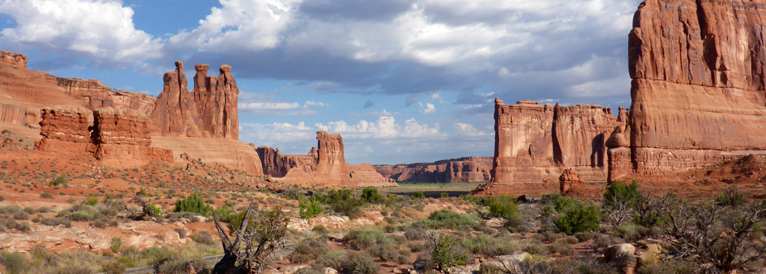
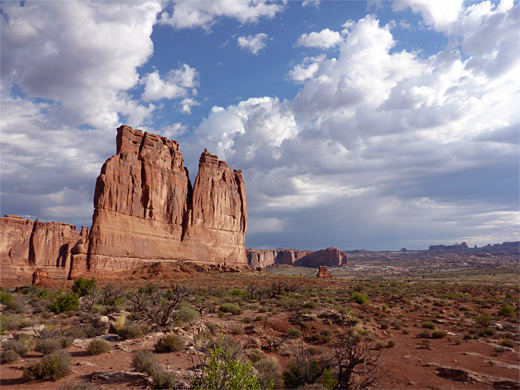
Courthouse Towers
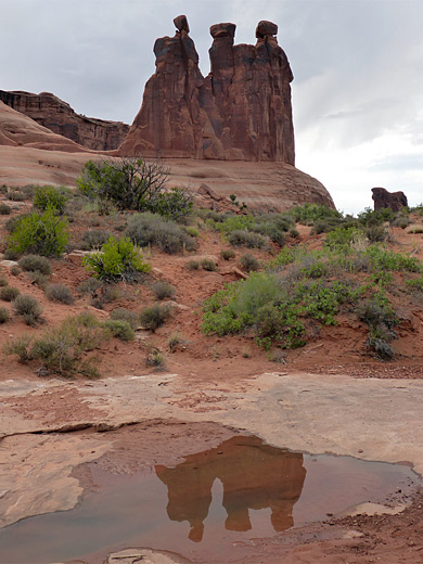
Firstly, the road reaches Park Avenue and Courthouse Towers - monolithic spires and ridges of rock standing isolated in largely flat terrain, which have been featured in several cinema films, most famously Thelma and Louise in 1991. A one mile trail runs along the Avenue, starting and ending at trailheads along the road, and it is easy to take short cross-country walks towards other sites of interest; named features include Sheep Rock, the Three Gossips, The Organ and Tower of Babel. There are no major arches hereabouts except Ring Arch, reachable by a 1.5 mile off-trail hike along Courthouse Wash.
The Windows Section
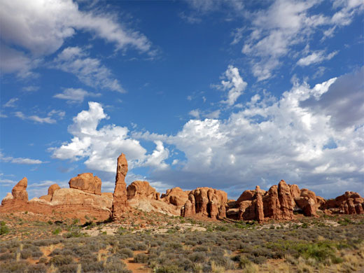
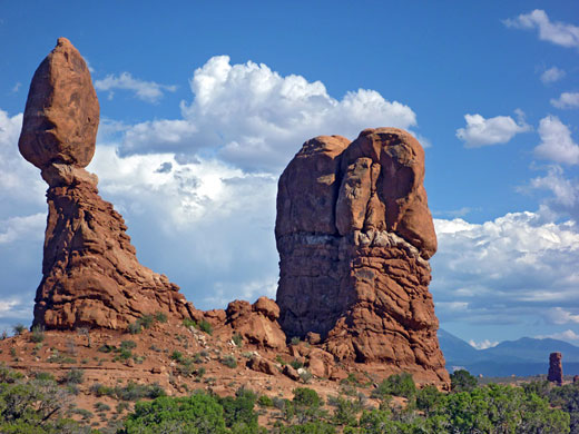
After Courthouse Towers, the park road crosses an open, undulating landscape of petrified sand dunes and eroded pinnacles for 5 miles, before a turn-off to the east leads to the Windows Section, the first major concentration of arches and spires, that bear self-explanatory names such as Double Arch, Cove of Caves and Balanced Rock. Everything of interest in this area can be seen either from the road or by short walks, so all visitors go at least this far. Near the junction, the Garden of Eden is a particularly beautiful area of whitish slickrock, green bushes and red columns, soon after which the road ends at a loop with several large parking lots. Two popular trails begin here, one (0.4 miles) to Double Arch, the other a 1.2 mile circuit that passes three arches - North Window, South Window and Turret.
Arches Tours
Hiking, sight-seeing and 4WD excursions.
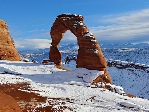
Delicate Arch
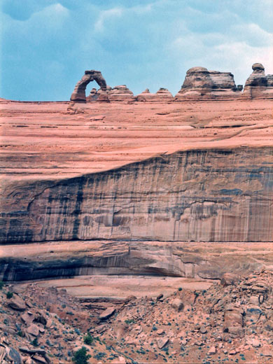
2.5 miles further along the main road, another turning leads to Wolfe Ranch, an old log cabin built next to a seasonal creek by early settlers in 1888. From the ranch a 1.5 mile trail crosses the creek via a small, swaying suspension bridge and leads across smooth exposed slickrock to the especially scenic Delicate Arch; perched precariously on the edge of a small canyon, this is the most famous arch in the park and has been adopted as the state symbol, appearing on Utah Centennial vehicle registration plates. As well as the arch, the end of the trail offers magnificent views of the rocky, multicolored land that characterizes the park, and across to the snow-covered La Sal Mountains near the Colorado border. The road ends one mile beyond the ranch at Delicate Arch Viewpoint, though the arch is difficult to see from the road itself. A steep trail climbs 200 feet to the edge of a canyon and offers much better views.
The Fiery Furnace
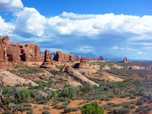
The next major feature is the Fiery Furnace - not arches, but an intricate maze of eroded red and cream-colored ridges with narrow gullies between them. Many people used to become lost walking through this area, and now it may only be explored as part of a ranger guided tour. There is a good viewpoint close to the road, of both the Furnace and Salt Valley, a long depression running through the center of the park. As its name suggests, the valley and all the underlying rock is made of unstable salt deposits, and it was the shifting and bucking of these layers that caused the heavier sandstone rocks on top to become distorted, creating the uneven landscape of fins and ravines found in many places within the park.
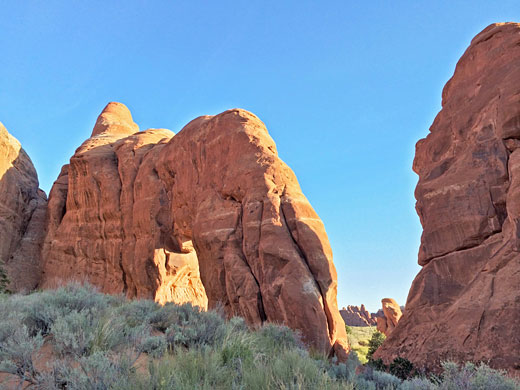
Devils Garden
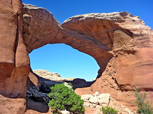
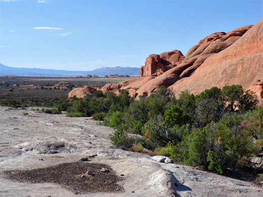
Past the Fiery Furnace, the road continues past several other large arches including Sand Dune, Broken and Skyline, and terminates at Devils Garden from where a 6 mile loop trail leads to seven major arches including 290 foot wide Landscape Arch, the longest in the world. The park campground is located nearby, offering 52 sites, quite well separated, in a very scenic setting. Drinking water is available.
Klondike Bluffs
Because of deep sand and occasional steep grades, a 4WD vehicle is required to visit most backcountry areas of Arches National Park, which include Klondike Buffs, a scenic concentration of arches and fins towards the northwest corner. This can also be accessed by the Salt Valley Road starting from US 191 outside the park, and is the only region suitable for backpacking.
Trails of Arches National Park
All paths in Arches National Park
Featured Arches Trails
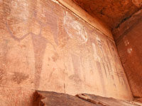
Courthouse Wash Rock Art
★★★★★
★★★★★
0.5 miles, 60 feet
Large panel of pictographs, and some petroglyphs, in an alcove overlooking the Colorado River, along the south edge of the national park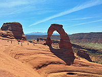
Delicate Arch Trail
★★★★★
★★★★★
1.5 miles, 480 feet
The most famous feature in the park is reached by a moderately easy trail that starts over sandy ground then climbs more steeply up rocky slopes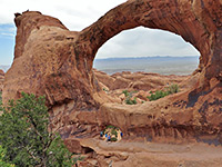
Devils Garden Trail
★★★★★
★★★★★
7.5 miles, level overall
The longest trail in the park winds across slickrock and sand dunes, through the largest area of arches situated away from the main road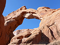
Herdina Park
★★★★★
★★★★★
4 miles, 250 feet (loop)
Isolated group of fins and ravines containing two major arches; explorable by cross-country hiking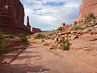
Park Avenue Trail
★★★★★
★★★★★
1 mile, 320 feet
A popular route through a short canyon framed by fins and pinnacles, passing close to several famous landmarks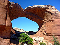
Skyline, Sand Dune, Broken Arches
★★★★★
★★★★★
2.5 miles, level overall
Varied loop hike to four large arches, each different in characterArches Wildflowers
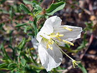
Photographs and descriptions of flowering plants found in the national park
Arches - Nearby Places
- Dead Horse Point State Park (28 miles) - high promontory overlooking Colorado River canyons
- Island in the Sky, Canyonlands National Park (25 miles) - isolated plateau between the Green and Colorado rivers
Arches - Similar Places
- Natural Bridges National Monument, Utah - three large natural bridges
- Potash Road, Utah - scenic backroad alongside the Colorado River, passing several arches
All Contents © Copyright The American Southwest | Comments and Questions | Contribute | Affiliate Marketing Disclosure | Site Map