Highlights:
The Colorado River, from its source high up in Colorado's Rocky Mountains to the Sonoran Desert at Yuma, Arizona. The river passes seven NPS units (Rocky Mountain, Colorado, Arches, Canyonlands, Glen Canyon, Grand Canyon, Lake Mead), plus many other scenic places
Type:
One way, beginning at Denver
Length:
1,905 miles, 3,065 km
Duration:
14 days minimum; days or more with optional side trips
Seasons:
Fall is best, since the roads in Rocky Mountain NP are still open, while in the deserts, the temperatures have started to decrease
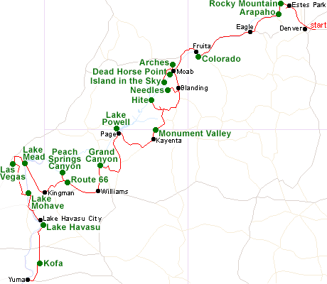
Map of the Colorado River Itinerary
Please refer to the disclosure notice for information about the affiliate (commissionable) links on this page.
Day 1 - Denver to Estes Park, 90 miles
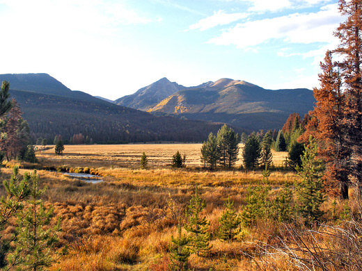
From Denver, well traveled roads lead northwest through Boulder and on to Estes Park, gateway town to Rocky Mountain National Park. The Colorado River begins within the park, west of the continental divide, but the east side of the mountain crest deserves at least a day's exploration; the most scenic locations, and the best trails, are found along the side road to Bear Lake.
Day 2 - Estes Park to Eagle, 140 miles
The route west from Estes Park is via Trail Ridge Road, the highest paved highway in America, which crosses the continental divide and descends into a deep ravine, containing the very upper end of the Colorado River. The Lulu City Trail follows the river to its source near La Poudre Pass; while the road turns south, running close to the Colorado as it flows through Kawuneeche Valley, a good location to spot wildlife, then exits Rocky Mountain National Park. A little further, the Colorado forms two large lakes (Shadow Mountain and Granby), part of Arapaho National Recreation Area. From here, US 40 and later Highways 1 & 131 stay close to the Colorado all the way to its confluence with the Eagle River, beside I-70, from where the little town of Eagle is a short distance further.
Optional extra day: more hiking in the west of Rocky Mountain National Park
Day 3 - Eagle to Fruita, 150 miles
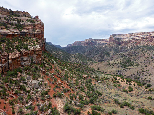
I-70 stays close to the Colorado River for 110 miles to Grand Junction, where the red rocks of the Colorado Plateau first come into view. On the south side of the river, Colorado National Monument (named after the river rather than the state), contains deep sandstone canyons, pinnacles and other eroded formations, and offers many good hiking trails. After exiting the west side of the monument, the nearest lodging is in the quiet town of Fruita.
Day 4 - Fruita to Moab, 130 miles
The interstate is followed for a little while longer, until the junction with Hwy 128; this very scenic road follows right beside the Colorado through a deepening, sheer-sided gorge, past the red rock buttes of Castle Valley and on to the US 191 junction, from where Arches National Park is a few miles north, and Moab a few miles south.
Optional extra day: more hiking in Arches, hikes in the Castle Valley area, such as Professor Creek, and a side trip along Potash Road, which follows the Colorado west of Moab
Affiliate disclosure
Use voucher code VIATORAFF10 for 10% off all tours, valid until May 16th 2025
Use voucher code VIATORAFF10 for 10% off all tours, valid until May 16th 2025
Day 5 - Island in the Sky (Canyonlands NP), 105, miles
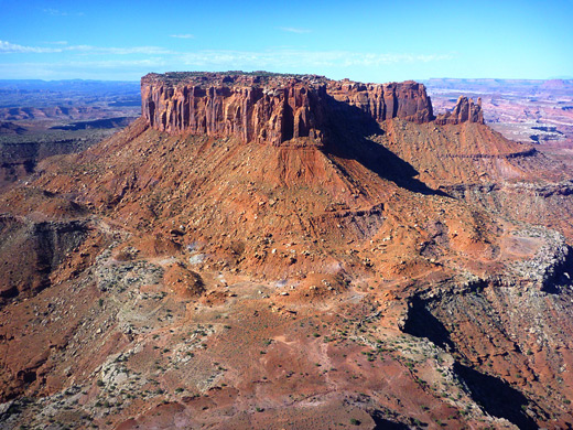
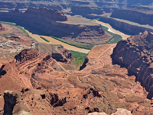
The Island in the Sky district of Canyonlands National Park is one of the highlights of the Southwest; an isolated mesa between the deep, branched canyons of the Green and Colorado Rivers. The park road has overlooks, short trails on the mesa top, and strenuous routes down to the rivers. En route from Moab, Dead Horse Point State Park has more of the same scenery.
Optional extra day: more hiking in the Island in the Sky
Day 6 - Moab to Blanding, 155 miles
The next access to the Colorado River is in the Needles section of Canyonlands National Park; again there are many spectacular roadside overlooks, and a variety of trails, one (5.5 miles) leading to a viewpoint of the confluence with the Green River. The night is spent in Blanding along US 191.
Optional extra day: more hiking in the Needles
Day 7 - Blanding to Kayenta, 210 miles
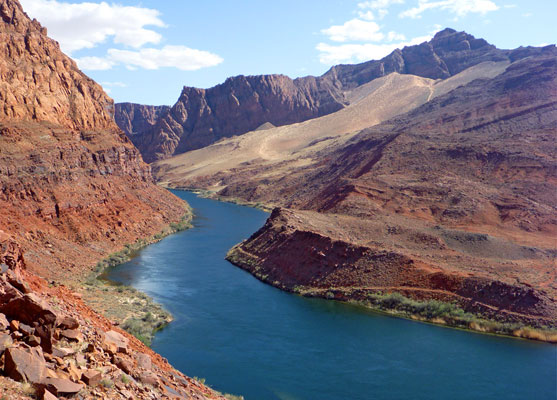
UT 95 is another of Utah's most scenic routes. West of Blanding, this road crosses undulating land including Comb Ridge, then passes the junction for Natural Bridges National Monument, and descends along White Canyon to Hite, at the far upper end of Lake Powell, by the Colorado-Dirty Devil River confluence. Returning south, the route is along UT 261, across Cedar Mesa, past Valley of the Gods, Mexican Hat and Monument Valley, to Kayenta in Arizona.
Optional extra day(s): explore some of the nearby slot canyons; spend more time in Monument Valley, or hike to the Anasazi ruins of Cedar Mesa
Day 8 - Kayenta to Page, 120 miles
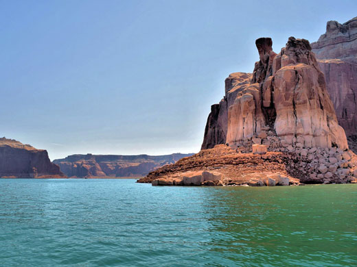
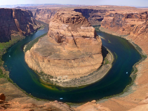
A two hour drive across the Navajo Indian Reservation reaches Page, beside Glen Canyon Dam at the downstream end of Lake Powell. Besides the lake itself, two popular locations nearby are Antelope Canyon and Horseshoe Bend, this latter a tight curve in the Colorado River canyon a few miles south of the dam.
Day 9 - Page to Grand Canyon, 145 miles
The route from Page to the Grand Canyon descends over the Echo Cliffs to the Painted Desert, turns west alongside the Little Colorado River then climbs to the forested Coconino Plateau; first sight of the canyon is at Desert View, from where the Colorado can just be seen, one mile below. The road (East Rim Drive) passes plenty more viewpoints and trailheads en route to Grand Canyon Village.
Optional extra day: Lees Ferry - tiny settlement beside the Colorado River at the head of Marble Canyon, a short distance from Page
Day 10 - Grand Canyon to Williams, 80 miles
Most of the next day is also spent at the Grand Canyon, enough perhaps for one of the longer hikes such as the Bright Angel Trail to Plateau Point (a viewpoint above the Colorado's inner gorge), before heading south along Hwy 64 to Williams.
Day 11 - Williams to Kingman, 160 miles
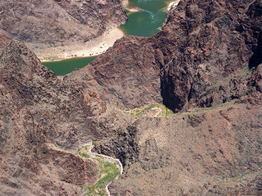
From Williams, the journey west is via I-40 and old Route 66, to Peach Springs in the Hualapai Indian Reservation, from where a gravel track follows Peach Springs Canyon all the way to the Colorado River - the only such road anywhere in the Grand Canyon. Route 66 then continues towards Kingman, a historic railway town.
Day 12 - Kingman to Las Vegas, 110 miles
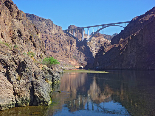
The Hoover Dam, Lake Mead and Las Vegas are the highlights of day 12, spending the night at one of the many casinos on the Strip - Excalibur is one of the more reasonable priced options. The dam was built across the Colorado in 1935, and has recently been joined by a new road bridge, carrying US 93 across Black Canyon just downstream.
Optional extra day: other sites around Lake Mead, such as Valley of Fire, or Pearce Ferry, beside the Colorado at the lower end of the Grand Canyon
Day 13 - Las Vegas to Lake Havasu City, 160 miles
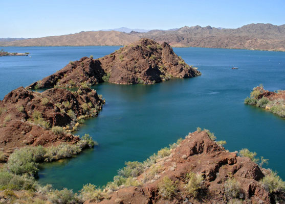
The Colorado is sighted again at Laughlin beside Lake Mohave, after which the route is through Bullhead City, Needles and then Lake Havasu City, beside the warm waters of Lake Havasu.
Day 14 - Lake Havasu City to Yuma, 150 miles
The final section of the tour follows the Colorado south past the lower end of the Bill Williams River to Parker, where the highway leaves the river and heads due south, across the parched deserts of Kofa National Wildlife Refuge to Yuma. This sprawling city has a quiet, historic center right beside the Colorado, including several parks and waterside recreation areas.
All Contents © Copyright The American Southwest | Comments and Questions | Contribute | Affiliate Marketing Disclosure | Site Map