Horseshoe Bend, Glen Canyon National Recreation Area
Utah > Glen Canyon National Recreation Area > Page > Horseshoe Bend
Horseshoe Bend
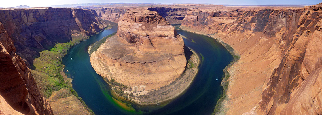
One of the most photographed places in Arizona; a deeply entrenched meander of the Colorado River, part of the short section of Glen Canyon that remains intact
Length: 0.6 miles
Elevation change: 170 feet
Difficulty: Easy
Type: One way, maintained trail
Usage: High
Season: All year
Trailhead: Parking area along US 89, 3 miles south of Page
Rating (1-5): ★★★★★
Elevation change: 170 feet
Difficulty: Easy
Type: One way, maintained trail
Usage: High
Season: All year
Trailhead: Parking area along US 89, 3 miles south of Page
Rating (1-5): ★★★★★

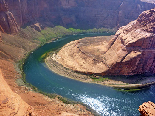
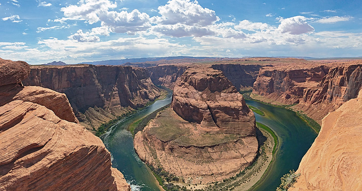
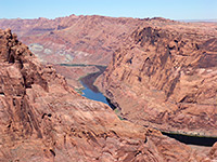
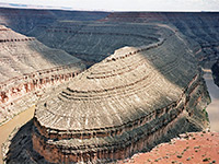
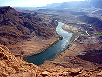
As most of Glen Canyon is submerged beneath Lake Powell, the only intact section is downstream of the dam, where the Colorado River flows through the 1,000 foot deep ravine for 15 miles, until the cliffs open out abruptly at Lees Ferry. Apart from viewpoints around the US 89 bridge and the dam itself, the canyon can be seen via two trails - the lightly used and rather strenuous Spencer Trail starting at Lees Ferry or the much easier and very popular half mile path to Horseshoe Bend Overlook, where the river curves round by 270 degrees.
This is one of the most spectacular and oft-photographed places in Arizona, if not the whole of the Southwest, and is especially beautiful around late afternoon, when the upper walls, and the plateau beyond, are perfectly illuminated by the setting sun. To capture the full extent of the scene (a horizontal field of view of about 90 degrees) needs either a fisheye lens or merging of three or four regular photos, in portrait orientation.
Becuase of increasing visitation, and concerns about safety, a metal fence was constructed at the Horseshoe Bend viewpoint during winter 2017/2018, accompanied by trail upgrades and two shaded benches, soon followed by an enlarged, staffed parking area along the approach road, US 89. Visitors may still experience unfenced views, hovever, by walking a little further along the rim, to the north or south.
Walking tour with a Navajo guide, or view from above in a helicopter.
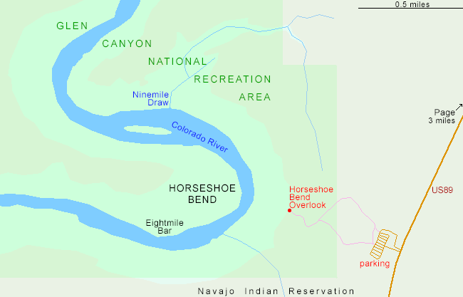
The overlook at Horseshoe Bend is served by a large parking area on the west side of US 89, five miles south of Glen Canyon Dam; big enough to accommodate the tour buses that often stop here, though the ever-increasing popularity can mean that all spaces are taken by late morning. Posts were installed on nearby verges in summer 2018, preventing any overflow parking. The parking lot, and the adjacent land, are part of the Page metropolitan area, just outside Glen Canyon NRA (the boundary is crossed half way along the trail), hence it is the City of Page which collect parking fees, $10 per vehicle in 2024, and staff the entrance booth. The border of the Navajo Reservation is 600 feet south.
The wide path to Horseshoe Bend climbs a little to a low, flat-topped hill then descends gently down the far side, across a mix of slickrock and dunes to the unfenced overlook, on the rim of cliffs that are quite sheer for most of the 1,100 foot drop to the river below. The water in the Colorado is slow moving, greenish blue in color and edged by thin strips of bright green vegetation - a striking contrast to the red-brown Navajo sandstone cliffs at either side. There are often several rafts and boats in view, making the short upstream journey from Lees Ferry; sandbanks and bushy areas along the river provide many stopping places. The return route can be the same way, or along an alternate path to the north, to make a loop hike.
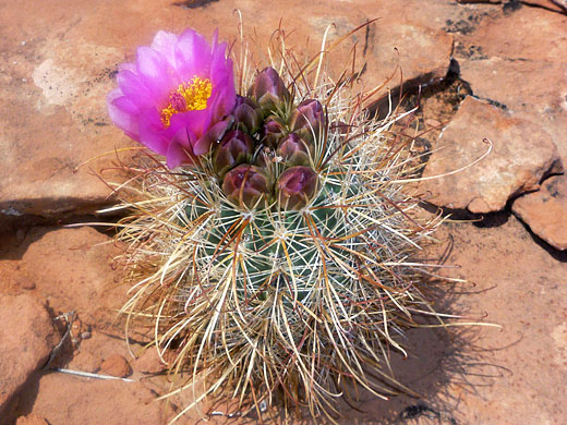
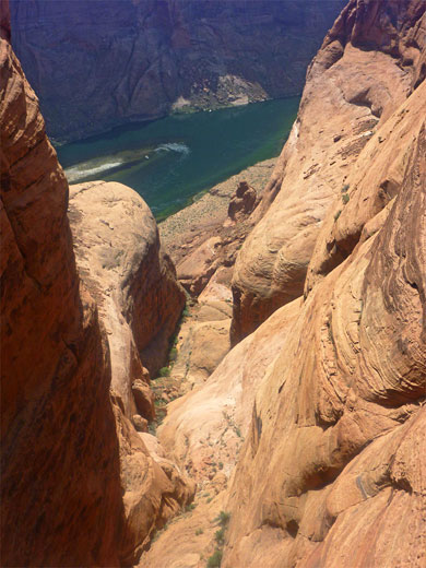
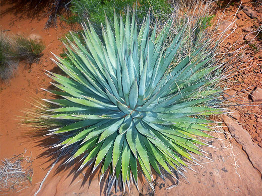
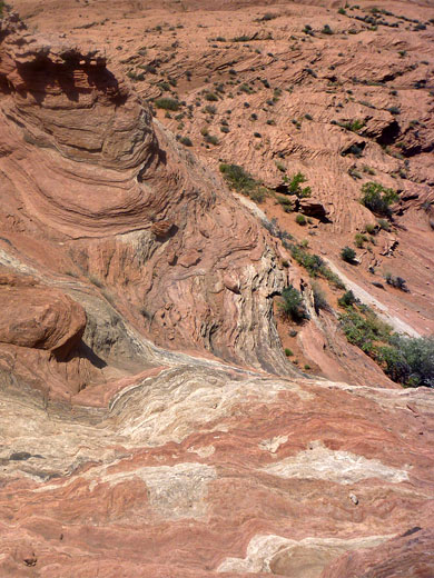
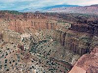
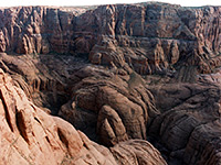
Slightly better, more elevated views can be had by climbing a small knoll just north of the main overlook, while walking either direction along the rim gives a different perspective of the scene. One other feature of interest in the vicinity is a short but very deep tributary ravine (Ninemile Draw) to the northwest, reached by a one mile walk over the slickrock plateau, which is fairly level, formed of fractured, angled sandstone strata, heavily eroded into small cliffs, mounds and gullies. An interesting selection of wildflowers and desert plants grow in crevices and around potholes, including Utah agave, echinocereus coccineus and the less common sclerocactus parviflorus.
This is one of the most spectacular and oft-photographed places in Arizona, if not the whole of the Southwest, and is especially beautiful around late afternoon, when the upper walls, and the plateau beyond, are perfectly illuminated by the setting sun. To capture the full extent of the scene (a horizontal field of view of about 90 degrees) needs either a fisheye lens or merging of three or four regular photos, in portrait orientation.
Becuase of increasing visitation, and concerns about safety, a metal fence was constructed at the Horseshoe Bend viewpoint during winter 2017/2018, accompanied by trail upgrades and two shaded benches, soon followed by an enlarged, staffed parking area along the approach road, US 89. Visitors may still experience unfenced views, hovever, by walking a little further along the rim, to the north or south.
Map of Horseshoe Bend
Tours of Horseshoe Bend
Walking tour with a Navajo guide, or view from above in a helicopter.
Antelope Canyon FAQ
- Because of the spectacular, photogenic views! The 1,000 foot-deep, sheer-walled canyon of the Colorado River, the symmetric, graceful bend, the deep red rocks and rich greenish water, all ideally orientated for sunrise and sunset, and easily reached, by just a short walk from US 89.
- No, unlike nearby Antelope Canyon, the overlook is visited without permit or need for reservation, or a guide; only a $10 parking fee is required. The overlook is often included as part of a tour, however, typically also visiting other sites in the area. Some tours may approach the bend via a private track a short distance south, to an alternative overlook, within the Navajo Reservation.
- Goosenecks State Park in Utah contains perhaps the second most famous river meander on the Colorado Plateau; along the San Juan River. In Glen Canyon, the Colorado River makes another wide bend 3 miles southwest of Horseshoe, at the lower end of Water Holes Canyon, reachable by a cross-country walk in the Navajo Reservation (hiking permit required).
- No; drones are not allowed at Horseshoe Bend or anywhere else within Glen Canyon NRA.
- Early or late in the day, both because there are fewer people here, and also, the light is better; around sunrise the canyon is bathed in soft light, and the first rays on the top of the cliffs opposite the viewpoint reflect in the river below, while sunset enhances the already rich colors of the canyon and the plateau beyond.
- Not difficult at all - only 0.6 miles, on a hard surface, ADA-accessible. The trail rises gently by 30 feet to a low hill, then descends 140 feet to the viewpoint. The only possible problem is the heat, as in summer temperatures are regularly in the 90s (°F; high 30s °C).
- Navajo sandstone - on the plateau, and all of the canyon walls, with floodplain deposits and talus around the river.
- From below, on all day raft trips starting at the base of Glen Canyon Dam and ending at Lees Ferry - a 15.5 mile journey. Or, from above, on sight-seeing flights from Page airport, typical duration 30 minutes. One other option is a cross-country hike to the narrow promontory on the opposite side of the bend - either 6.5 miles from the west, starting via the Spencer Trail at Lees Ferry, or 7 miles from the northeast, beginning near Glen Canyon Dam.
Access
The overlook at Horseshoe Bend is served by a large parking area on the west side of US 89, five miles south of Glen Canyon Dam; big enough to accommodate the tour buses that often stop here, though the ever-increasing popularity can mean that all spaces are taken by late morning. Posts were installed on nearby verges in summer 2018, preventing any overflow parking. The parking lot, and the adjacent land, are part of the Page metropolitan area, just outside Glen Canyon NRA (the boundary is crossed half way along the trail), hence it is the City of Page which collect parking fees, $10 per vehicle in 2024, and staff the entrance booth. The border of the Navajo Reservation is 600 feet south.
Horseshoe Bend Overlook Trail
The wide path to Horseshoe Bend climbs a little to a low, flat-topped hill then descends gently down the far side, across a mix of slickrock and dunes to the unfenced overlook, on the rim of cliffs that are quite sheer for most of the 1,100 foot drop to the river below. The water in the Colorado is slow moving, greenish blue in color and edged by thin strips of bright green vegetation - a striking contrast to the red-brown Navajo sandstone cliffs at either side. There are often several rafts and boats in view, making the short upstream journey from Lees Ferry; sandbanks and bushy areas along the river provide many stopping places. The return route can be the same way, or along an alternate path to the north, to make a loop hike.
Surroundings
Slightly better, more elevated views can be had by climbing a small knoll just north of the main overlook, while walking either direction along the rim gives a different perspective of the scene. One other feature of interest in the vicinity is a short but very deep tributary ravine (Ninemile Draw) to the northwest, reached by a one mile walk over the slickrock plateau, which is fairly level, formed of fractured, angled sandstone strata, heavily eroded into small cliffs, mounds and gullies. An interesting selection of wildflowers and desert plants grow in crevices and around potholes, including Utah agave, echinocereus coccineus and the less common sclerocactus parviflorus.
Horseshoe Bend - Similar Hikes
All Contents © Copyright The American Southwest | Comments and Questions | Contribute | Affiliate Marketing Disclosure | Site Map