Highlights:
The best location in the USA to see petrified wood, here found in a particularly beautiful range of bright colors. A scenic drive runs through the park, also passing a section of the Painted Desert, several trailheads and many overlooks. The park also contains many petroglyphs
Nearby town:
Holbrook, 18 miles
Management:
Location:
35.060, -109.781 (north entrance) 34.792, -109.891 (south entrance)
Seasons:
All year; not too hot in summer, and receiving only light snowfall in winter
Rating (1-5):
★★★★★
Weather:


Petrified Forest NP is part of the Indian Lands itinerary
Petrified Forest - More Information
Overlooks and short trails along the 20 mile section of the park road between the railway and the southern entrance; six main areas
Geology - how the stone logs were formed
Featured Hotel
Best Western Arizonian Inn
 Popular hotel with outdoor heated pool, at the northeast end of Holbrook, 23 miles from the northern entrance to the national park along Interstate 40
Check Rates
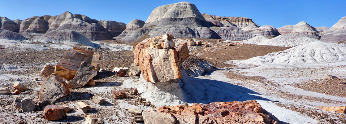
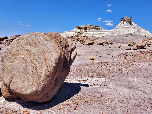
On first impression, the Petrified Forest may not sound very appealing as it comprises stone log fragments scattered over a rather remote and otherwise featureless section of Arizona desert. Apparently it comes as a disappointment to some who expect the trees still to be standing in thick rocky groves instead of lying flat in sections as they are. But the petrified logs are extremely beautiful with most unexpectedly bright colors, and the region includes a section of the scenic Painted Desert so it is well worth a visit especially as the site is quite easily reached, being close to the main east-west route interstate 40.
The fossil forest was initially protected in 1906, as a national monument (only the second in the country), then upgraded to Petrified Forest National Park in 1962.
The park is the fifth most visited NPS preserve in Arizona. One peculiarity, compared with other landscape-based parks, is that all closes by 5 pm (6 pm in summer), seemingly to prevent thefts of petrified wood that may be more likely in the dark. This does though often prevent experiencing the sunset.
Petrified Forest Table of Contents
- Map
- The North - the Painted Desert
- The South - Petrified Wood
- Camping in the national park
- Hiking in Petrified Forest National Park; maintained trails and backcountry routes
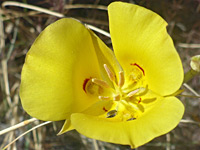
- Petrified Forest wildflowers
- Nearby places
- Similar places
Petrified Forest Location
Map of Petrified Forest National Park.
Photographs
General views; all photographs
The North - the Painted Desert
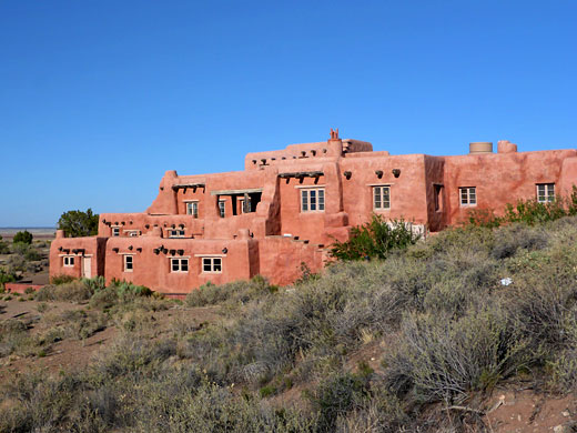
A 27 mile road runs through Petrified Forest National Park, from exit 311 of I-40, south to US 180. The surroundings are for the most part empty grasslands, and the closest town is Holbrook, 26 miles to the west. The visitor center is at the north end and there is a small museum at the south entrance. In the north, the first few miles of the road wind along the rim of a mesa overlooking the Painted Desert, past eight viewpoints of the rolling multicolored landscape, with one short trail (Painted Desert Rim) along the cliff edge. This starts from the Painted Desert Inn, an elegant adobe structure built in 1937. The patterns visible in the eroded soft sedimentary rocks below the rim are due mainly to hematite (red), limonite (yellow) and gypsum (white), and the colors are especially striking at sunset.
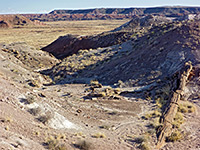
The park boundaries have been extended twice, in 1932 and 1970, to include a large area of the desert to the north, and although there are no maintained paths in this region, off-trail hiking and back-country camping are permitted; the main destination is the Black Forest, which has large amounts of petrified wood, darker in color compared to other locations, and including many complete trunks, together with badlands and photogenic, eroded rock formations. Also in this area is Onyx Bridge, a 40-foot tree that spans a dry wash, though the log partially collapsed a few years ago. One more recently accessible destination (free permit required) is the Devils Playground, an area of badlands and hoodoos near the west edge of the park, reached from I-40 exit 303 and explorable by a 7 mile partial loop hike. The Painted Desert extends about 150 miles across northeast Arizona, from the Petrified Forest towards the Little Colorado River, Tuba City and beyond.
The South - Petrified Wood
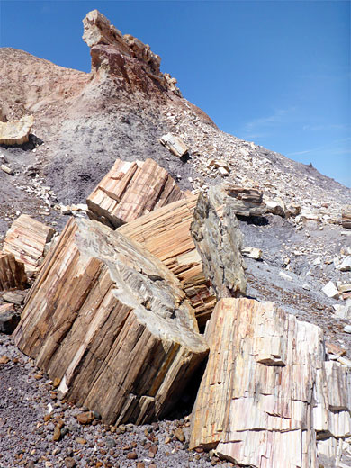
After the final overlook of the Painted Desert (Lacey Point), the park road turns due south, crosses the interstate and a branch of the Atchison, Topeka & Santa Fe railway, then passes through the petrified region. The first feature of interest is an Indian ruin - Puerco Pueblo, originally a collection of 76 rooms and a kiva - which is toured by a 0.3 mile loop trail, and is just one of over 500 archaeological sites within the park. Another is found 1.5 miles south at Newspaper Rock, a sandstone outcrop bearing hundreds of petroglyphs dating from around 1000-1300 AD. There are more petroglyphs along a short side track close to the south edge of the park (starting from Giant Logs museum), but the main viewpoints along the southern section of the park are of the petrified wood. Unusually for a national park, there are no extended maintained trails, only short paths close to the road, though a number of backcountry primitive routes are availale.
Camping in Petrified Forest NP
Partly to protect the natural resources, there are no developed campsites in Petrified Forest National Park; the only camping allowed within the park is for backpackers in the Painted Desert/Black Forest wilderness area, north of the interstate. The surrounding land also has patches of petrified wood, and is privately owned and fenced off, so there is no place for free camping nearby. The closest options for this seem to be one of several junctions of I-40, either side of the park turn-off - exits 303, 320 and 325, each of which has short tracks leading into the desert where overnight parking/camping is possible.
Trails of Petrified Forest National Park
Black Forest, Onyx Bridge
★★★★★
★★★★★
2.5 miles, 350 feet
Partly off-trail hike to a wilderness area in the Painted Desert, including many complete petrified trunks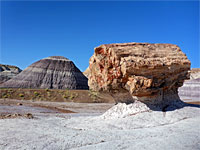
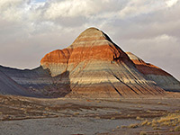
Blue Mesa Trail
★★★★★
★★★★★
1 mile, 130 feet (loop)
Paved loop past many logs lying on undulating purple-grey mounds of bentonite clay, beneath a narrow plateau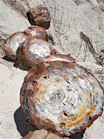
Crystal Forest Trail
★★★★★
★★★★★
0.75 miles, 30 feet (loop)
Paved loop across badlands with many large, colorful speciments of fossilized wood, some containing crystals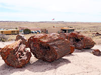
Giant Logs Trail
★★★★★
★★★★★
0.4 miles (loop), 40 feet
Popular, paved loop trail around a low sandstone hill on the west side of Rainbow Forest Museum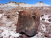
First Forest Point
★★★★★
★★★★★
2.1 miles, 170 feet (loop)
Primitive route past buttes, badlands and petrified wood, to a viewpoint at the edge of a mesa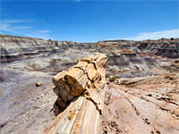
Historic Blue Forest Trail
★★★★★
★★★★★
1.3 miles, 200 feet
1930s route through extensive, multicolored badlands with scattered petrified wood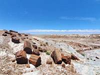
Jasper Forest Trail
★★★★★
★★★★★
1.2 miles, 100 feet
Follows an old road though an area of much petrified wood, to the base of Eagle Nest Rock, formerly a famous hoodoo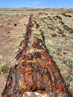
Long Logs Trail
★★★★★
★★★★★
1.6 miles (loop), 50 feet
Circuit past scattered, grayish mounds and hundreds of large, beautifully colored logs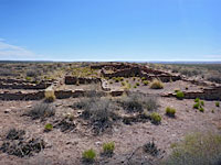
Puerco Pueblo Trail
★★★★★
★★★★★
0.3 miles (loop), 15 feet
Loop around the site of an Ancestral Puebloan dwelling from the 1500s; also passes many petroglyphsPetrified Forest Wildflowers
Petrified Forest - Nearby Places
- Coronado Trail (80 miles) - winding road through the White Mountains, between Clifton and St Johns
- Meteor Crater (76 miles) - world famous, privately owned meteorite crater
Petrified Forest - Similar Places
- Bisti Wilderness, New Mexico - distant landscape of colorful mounds and fossils
- Escalante State Park, Utah - petrified wood and a reservoir
All Contents © Copyright The American Southwest | Comments and Questions | Contribute | Affiliate Marketing Disclosure | Site Map