National Parks, National Monuments and National Recreation Areas in Arizona
Other Arizona listings: national forests, state parks and national wildlife refuges.
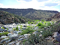
Created in 2000, Agua Fria National Monument contains high elevation desert with grassy mesas, steep-sided canyons, saguaro cactus forests and ancient Indian relics, on the east side of interstate 17 between Phoenix and Flagstaff. There are few visitor facilities and much of the area is reachable only by rough tracks or off-trail hiking. The main attraction is the deep canyon of the Agua Fria River, a year round drainage. Description | Photographs |
|
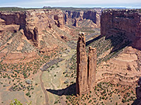
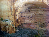
In the Navajo Indian Reservation of northeast Arizona, sheer-walled Canyon de Chelly is one of the best places in the state to see ancient Anasazi ruins, even though most may only be visited in the company of a Navajo escort. The most famous site is White House Ruins, reached by a one mile trail. Two scenic drives run along the north and south rims of the canyon, and have many overlooks. The canyon is floor is still inhabited and farmed by the Navajo, as it has been for thousands of years. Description | Map | Photographs |
|
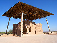
This small national monument near the desert towns of Coolidge and Casa Grande (50 miles southeast of Phoenix) features a large, well preserved four-floor adobe building dating from the Hohokam period of the fourteenth century. Other highlights are an informative visitor center, a collection of Sonoran Desert plants and a shady picnic area. In summer this area is one of the hottest in the state, with temperatures up to 120°F. Description and Map | Photographs |
|
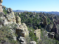
Chiricahua National Monument covers a small area of the remote Chiricahua Mountains in far southeast Arizona, home to an unusually wide variety of plant and animal species, and containing large expanses of eroded volcanic rocks that form pinnacles, hoodoos and narrow canyons. The distant location and limited access mean that relatively few people visit, so the place is peaceful and unspoilt. Description | Trails | Map | The Big Loop |
|
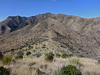
In the Coronado National Forest bordering Mexico, Coronado National Memorial celebrates the achievements of Francisco Vásquez de Coronado, who led the first recorded European expedition to America, in 1540. The visitor center has many historical exhibits but the attraction for most visitors is the rugged and scenic terrain, which is crossed by several hiking trails, one leading right up to the international border. Description |
|
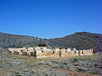
In the Chiricahua Mountains of far southeast Arizona, Fort Bowie was the staging post for attacks in the late nineteenth century by the US military on the native Chiricahua Apache, a campaign completed in 1886 after surrender of the last Indian leader (Geronimo). The fort was abandoned in 1894 and became a National Historic Site in 1960. Access is by an unpaved road followed by a 1.5 mile hike, along an easy trail that passes other historic relics including an old cemetery. Description and Map | Photographs |
|
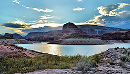
Although mostly in Utah, the southern end of Glen Canyon NRA is in Arizona, as is the main center for visitor activities, at Wahweap near Page. The NRA contains the vast expanse of Lake Powell, created in 1964 after flooding of the Colorado River by Glen Canyon Dam. The lake is surrounded by many square miles of largely inaccessible red rock wilderness, crossed by numerous narrow canyons, and it offers endless possibilities for exploration, both on land and on water. Description | Map | Page | Hite | Halls Crossing | Bullfrog Marina |
|
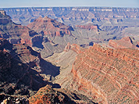
Perhaps the most famous national park in the world, Grand Canyon extends for over 200 miles along the Colorado River in north Arizona, though most visitors see only the short section viewable from the South Rim Drive. A small part of the North Rim is also accessible by paved road (closed by snow in winter), while access to the remainder is limited to various dirt tracks and long trails. Description | Map | South Rim | North Rim | Havasupai | Hualapai | Tuweep |
|
| Grand Canyon-Parashant National Monument (NPS/BLM) The (relatively) recently created Grand Canyon-Parashant National Monument contains some of the most rugged and remote terrain in Arizona - on the north side of the Colorado River, bordering Lake Mead NRA and Grand Canyon NP. Primitive camping and off-trail hiking are the attractions here; there are no services, and only a few (unpaved) roads. |
|
| Hohokam Pima National Monument (NPS) On the Gila River Indian Reservation south of Phoenix, Hohokam Pima National Monument was created in 1972 and protects the site of a Hohokam village dating from around 1200. The village was excavated but subsequently reburied, leaving no visible trace. The site is not open to the public and has no facilities. |
|
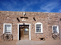
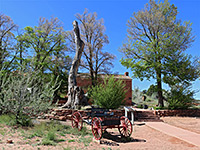
A homestead and store dating from the mid 19th century are the two attractions of Hubbell Trading Post National Historic Site, located at Ganado on the Navajo Indian Reservation of northeast Arizona. The trading post is still in regular use, the oldest such establishment in the state. Visitors may walk around the outbuildings, which include a large barn with historic equipment, and take a guided tour of the Hubbell homestead. Description | Photographs |
|
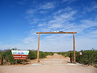
The desert ironwood tree and the saguaro cactus are the dominant plants of the Ironwood Forest National Monument, a 129,000 acre BLM-managed preserve covering a mostly roadless section of the Sonoran Desert east of Tucson. The monument also contains a working copper mine and several ghost towns, though no visitor facilities; people come here for solitude, primitive camping, off-trail hiking and wildlife study. Description | Photographs |
|
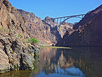
One of several Southwest parks along the Colorado River, Lake Mead NRA is centered on the huge lake formed in 1935 by construction of the Hoover Dam across Black Canyon, 25 miles from Las Vegas. It also contains the smaller Lake Mohave to the south, behind Davis Dam. Both lakes are surrounded by rough, roadless desert lands but the west shoreline of Lake Mead is quite accessible, and has various beaches, marinas, overlooks and picnic areas. Description | Map | Photographs | Hoover Dam | Lake Mohave |
|
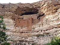
There are ten national monuments in Arizona preserving ancient dwellings but Montezuma Castle is probably the most spectacular - a beautifully preserved 5 floor structure built high above ground in an alcove in the limestone cliffs bordering Beaver Creek, a tributary of the Verde River in the center of the state, just off I-17. The national monument also includes Montezuma Well, a flooded limestone sinkhole a few miles east. Description and Map | Photographs |
|
This little-visited national monument contains three ancient cliff dwellings on the Shonto Plateau, south of Monument Valley in the middle of the Navajo Indian Reservation. One (Inscription House) is closed to the public indefinitely, while the other two may be seen via ranger-led hikes; 2 miles to the main site, Betatakin, or 8 miles to the distant Keet Seel ruins. Both are open daily during summer but Keet Seel is closed at other times, and Betatakin has only limited access. There is no entrance fee, and no charge to stay at the campground. Description and Map |
|
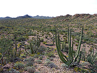
Perhaps the best of the desert-themed preserves in Arizona, Organ Pipe Cactus covers a large area of pristine wilderness at the far south of the state, bordering Mexico. Besides the organ pipes, the monument also has many saguaro, plus examples of the much rarer senita, another tall, branched cactus species. The area is far from other popular locations, extremely hot in summer and is quite lightly visited, despite being very scenic. Description | Map | Photographs |
|
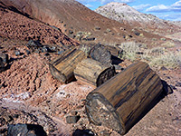
Huge amounts of beautifully colored petrified wood scattered over the Painted Desert of northeast Arizona have been protected since 1906 in the Petrified Forest National Park, occupying a sizeable area either side of I-40 east of Holbrook. The park has a scenic drive, museum and visitor center, several short trails and many viewpoints, though no campground. Description | Map | Photographs |
|
Pipe Spring is a reliable source of water in the otherwise arid desert of the Arizona Strip, and became a focal point for Mormon settlers in the mid nineteenth century, who built various buildings here and later a small fort, named Winsor Castle. The site became a national monument in 1923 and still has many of the original equipment and furnishings. The rather isolated location means that relatively few people visit. Description |
|
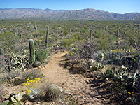
The saguaro cactus is widespread all across the Sonoran Desert of south Arizona but two particularly densely forested areas either side of Tucson have been preserved as Saguaro National Park. The west section (Tucson Mountain) is smaller, more accessible and has plenty of good, short trails, while the east section (Rincon Mountain) is more remote and includes a large mountainous region with summits over 8,000 feet. Description | West Section | East Section |
|
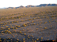
Half a million acres of cactus forests and isolated mountain ranges southwest of Phoenix make up the Sonoran Desert National Monument, a rugged but scenic preserve with a few trails and (unpaved) roads, but no developed facilities. Interstate 8 runs through the monument, with about half to the north, centered on the Maricopa Mountains, and half to the south, including parts of the Table Top and Sand Tank ranges. Description | Map | Photographs |
|
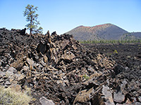
This small but fascinating national monument northeast of Flagstaff showcases the results of recent volcanic activity - colorful cinder cones and a huge expanse of jagged, twisted lava, still uncovered by any vegetation and pure black in color, even though the last major eruption was in 1065. The monument offers camping, hiking and roadside viewpoints, and is reached by a side road off US 89 that continues north into Wupatki National Monument. Description and Map | Photographs |
|
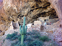
Tonto is one of Arizona's historical national monuments, containing the ruins of two Salado Indian cliff dwellings dating from around 1300. The buildings are located in a rocky, cactus-covered area on the west side of state route 188, overlooking Theodore Roosevelt Lake on the Salt River. One of the dwellings (the Lower Ruin) is reached by an easy, paved half mile trail; the other is 1.5 miles away and can only be seen on a ranger-led tour. Description and Map | Photographs |
|
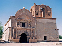
Centered on a 17th century Spanish Mission (in operation until 1848), Tumacacori National Historical Park in far south of Arizona is a peaceful and evocative place, with a varied collection of original buildings and artefacts, plus a nice courtyard garden. Access is from interstate 19, 18 miles north of Nogales. The park also includes two other sites, the Guevavi and Calabazas settlements, which are much less well preserved. Description |
|
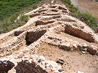
In central Arizona near the towns of Clarkdale and Cottonwood, Tuzigoot was the site of an 80-room, 12th century Sinaguan settlement, built on a small hill close to the Verde River. The small national monument includes just the ruin and an area of marshland beside the river; one hour is enough to view the settlement and look at the exhibits in the museum at the visitor center. Description and Map |
|
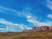
Established in 2000, Vermilion Cliffs National Monument contains a colorful sandstone escarpment at the edge of a remote, sandy plateau, and has three main sites - the Buckskin Gulch slot canyon, the rock formations of Coyote Buttes (including The Wave), and Lees Ferry, a tiny settlement beside the Colorado River-Paria River confluence. Most of the Vermilion Cliffs region is pathless desert, very interesting to explore for those suitably equipped. Description |
|
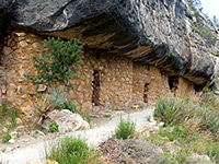
Ten miles east of Flagstaff, the 600 foot deep canyon of Walnut Creek was home to many Sinagua peoples in the 12th and 13th centuries, who built multi-room dwellings in protected alcoves high in the canyon walls. Some well preserved examples may be seen close up in the Walnut Canyon National Monument, via a short but steep loop trail. The area is reached by a side road off interstate 17. Description and Map | Photographs |
|
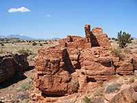
Wupatki features five large ruined pueblos from the Sinagua and Anasazi cultures, spread over a desert plain northeast of Flagstaff. All are close to a paved road, and easily viewable on short trails. The settlements were constructed from the local sandstone, deep red in color, and provide some very photogenic images; Wupatki is probably the most varied and scenic of Arizona's historical national monuments. Description | Map | Photographs |
|
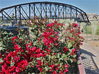
Yuma Crossing NHA comprises a varied collection of natural, cultural and historic resources centered on downtown Yuma and the traditional crossing point of the Colorado River. Components include Yuma Territorial Prison, Yuma Quartermaster Depot (Colorado River SHP), Pivot Point (location of the first railroad bridge) and two wetland areas along the river. Description and Map | Photographs |
All Contents © Copyright The American Southwest | Comments and Questions | Contribute | Affiliate Marketing Disclosure | Site Map