Historic Blue Forest Trail, Petrified Forest National Park
Arizona > Petrified Forest National Park > Hiking > Historic Blue Forest Trail
Historic Blue Forest Trail
1930s route that heads east from the park road across an open plain flanked by bluish mounds, then climbs into stark badlands with scattered petrified wood, winding along some narrow ridges, and descends to an intersection with the paved Blue Mesa Trail
Length: 1.3 miles
Elevation change: 200 feet
Difficulty: Easy to moderate
Type: One way, semi-maintained trail
Usage: High
Season: Spring, summer, fall
Trailhead: Pullout on the east side of the park road, just south of the Tepees
Rating (1-5): ★★★★★
Elevation change: 200 feet
Difficulty: Easy to moderate
Type: One way, semi-maintained trail
Usage: High
Season: Spring, summer, fall
Trailhead: Pullout on the east side of the park road, just south of the Tepees
Rating (1-5): ★★★★★

The Historic Blue Forest Trail is the most popular and possibly the best of Petrified National Forest's "off the beaten track" routes - minimally maintained paths that see far fewer visitors than the maintained, partly paved trails. This trail links the park road, near the Tepees, with the Blue Mesa Loop, a distance of 1.3 miles, gaining about 200 feet in elevation, encountering desert plains, multicolored badlands and scattered deposits of petrified wood, accompanied by fantastic views the whole way.
Starting from the road, the first half mile crosses open flats, following the course of an old road that once accessed the west edge of Blue Mesa; it then climbs into the undulating hills and ends by descending a ravine, to an intersection with the (paved) loop. The trail was built between 1934 and 1937 by the Civilian Conservation Corps and was much used for about 20 years, until both it and the lower access road were closed (in 1954), with visitors instead directed to the upper road and the newly constructed Blue Mesa Loop. The route was reopened, as a primitive trail, in 2013.
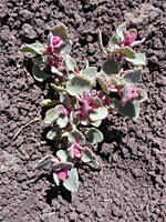
The only feature generally lacking along the route is plant life - wildflowers are very limited and much of the area is completely unvegetated, since all rainfall quickly runs off into gullies, or seeps below the porous surface. Only on flat ground at the higher reaches has enough soil accumulated for a few bushes and shrubs to gain a foothold.
The route is generally easy, with just a few short, steep parts; the only potential hazard are loose stones on the surface in some sections. The round-trip can be done in not much more than one hour.
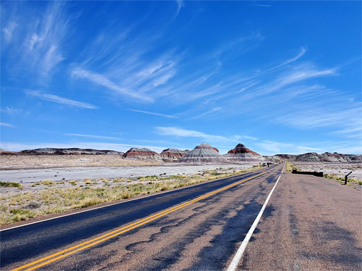
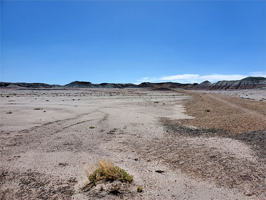
The Historic Blue Mesa trailhead is a pull-out on the long, straight section of the park road south of the Tepees, near milepost 14. The route starts by following the 1930s roadbed, heading east across wide, flat land near a few smaller tepees, and it looks rather unpromising at first - the surface is dusty and light in color, reflecting the sun to create intensely bright, airless conditions on hot days.
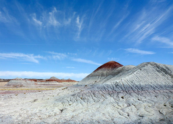
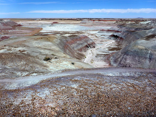
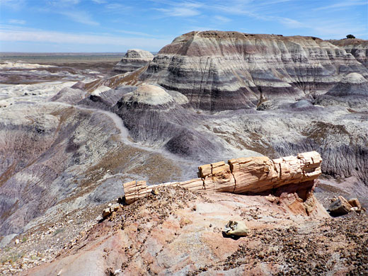
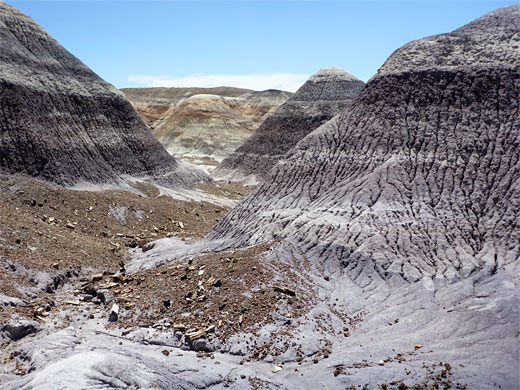
After half a mile the path reaches the edge of the badlands below the westernmost section of Blue Mesa, at the end of the former road. A narrower path continues, zig-zagging up the first slope and climbing further through an amazing, bluish-purple pastel landscape of mounds, ravines and benches, with a sprinkling of petrified wood, here rather muted in color. There are no cairns to show the way but the path is easy enough to follow, lined in some places by gravel used in the construction of the path in the 1930s. A quarter of a mile north there would appear to be a good array of rocky hoodoos, along the crest of a ridge, an area worthy of exploration though maybe not so easy to reach.
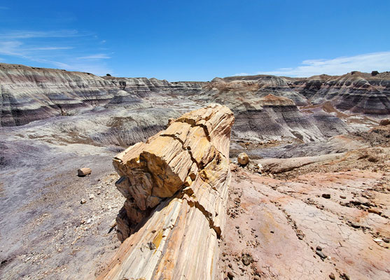
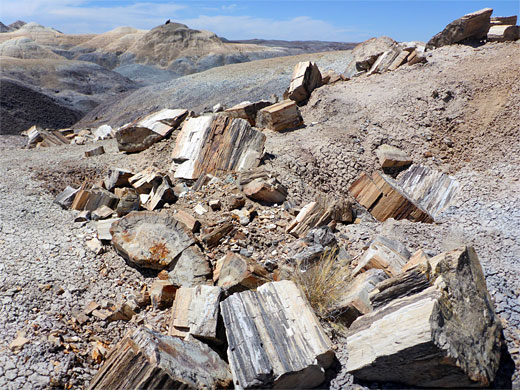
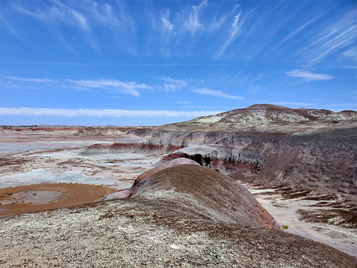
After a flatter section, the path rises some more and passes a large pedestal log, its north end protruding at the edge of a deep ravine; just below is a pile of large log sections, fallen from the main trunk over the centuries. A very short spur trail climbs to the top of an adjacent butte, while nearby are a few similar but smaller logs, jutting out of a smooth, steep slope. The route descends slightly then narrows and rises more steeply, up to the highest area of land, where the surroundings are grassier, and include a few juniper trees. The path continues, along the rim of a dramatic basin to the north, and then descends, between bluish slopes, down to the Blue Mesa Trail intersection.
Starting from the road, the first half mile crosses open flats, following the course of an old road that once accessed the west edge of Blue Mesa; it then climbs into the undulating hills and ends by descending a ravine, to an intersection with the (paved) loop. The trail was built between 1934 and 1937 by the Civilian Conservation Corps and was much used for about 20 years, until both it and the lower access road were closed (in 1954), with visitors instead directed to the upper road and the newly constructed Blue Mesa Loop. The route was reopened, as a primitive trail, in 2013.
The only feature generally lacking along the route is plant life - wildflowers are very limited and much of the area is completely unvegetated, since all rainfall quickly runs off into gullies, or seeps below the porous surface. Only on flat ground at the higher reaches has enough soil accumulated for a few bushes and shrubs to gain a foothold.
The route is generally easy, with just a few short, steep parts; the only potential hazard are loose stones on the surface in some sections. The round-trip can be done in not much more than one hour.
Historic Blue Forest Trailhead
The Historic Blue Mesa trailhead is a pull-out on the long, straight section of the park road south of the Tepees, near milepost 14. The route starts by following the 1930s roadbed, heading east across wide, flat land near a few smaller tepees, and it looks rather unpromising at first - the surface is dusty and light in color, reflecting the sun to create intensely bright, airless conditions on hot days.
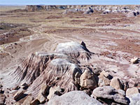
Badlands
After half a mile the path reaches the edge of the badlands below the westernmost section of Blue Mesa, at the end of the former road. A narrower path continues, zig-zagging up the first slope and climbing further through an amazing, bluish-purple pastel landscape of mounds, ravines and benches, with a sprinkling of petrified wood, here rather muted in color. There are no cairns to show the way but the path is easy enough to follow, lined in some places by gravel used in the construction of the path in the 1930s. A quarter of a mile north there would appear to be a good array of rocky hoodoos, along the crest of a ridge, an area worthy of exploration though maybe not so easy to reach.
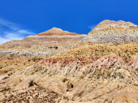
Blue Mesa
After a flatter section, the path rises some more and passes a large pedestal log, its north end protruding at the edge of a deep ravine; just below is a pile of large log sections, fallen from the main trunk over the centuries. A very short spur trail climbs to the top of an adjacent butte, while nearby are a few similar but smaller logs, jutting out of a smooth, steep slope. The route descends slightly then narrows and rises more steeply, up to the highest area of land, where the surroundings are grassier, and include a few juniper trees. The path continues, along the rim of a dramatic basin to the north, and then descends, between bluish slopes, down to the Blue Mesa Trail intersection.
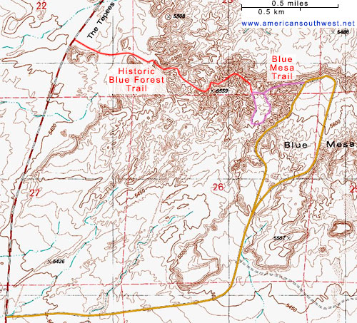
Topographic Map of the Trail
Blue Forest Wildflower
 Shadescale |
Historic Blue Forest Trail - Similar Hikes

All Contents © Copyright The American Southwest | Comments and Questions | Contribute | Affiliate Marketing Disclosure | Site Map