Highlights:
Mounds, multicolored rocks, hoodoos and eroded formations, scattered across relatively low relief terrain, centered on a narrow ridge just east of the continental divide; a rarely-visited location. Explored by a loop walk of up to 5 miles, or more
Nearby town:
Bernalillo, 88 miles
Management:
BLM
Location:
Along (unpaved) road 391, 2.5 miles west of Hwy 112
Seasons:
All year, unless after recent rainfall, as the approach road may be impassable
Rating (1-5):
★★★★★

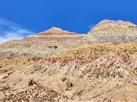
The San Jose Badlands are one of over a dozen badland regions of northwestern New Mexico, part of the group to the east of the continental divide and so ultimately draining into the Gulf of Mexico via the Rio Grande rather than the Gulf of California via the Colorado River, though are still considered to be within the San Juan Basin Badlands. The area is named after the underlying rock layers - all are from the San Jose Formation, a mix of variegated red/green shale, and red, brown or gray sandstone and conglomerate, and is situated 18 miles north of the village of Cuba, along Hwy 112.
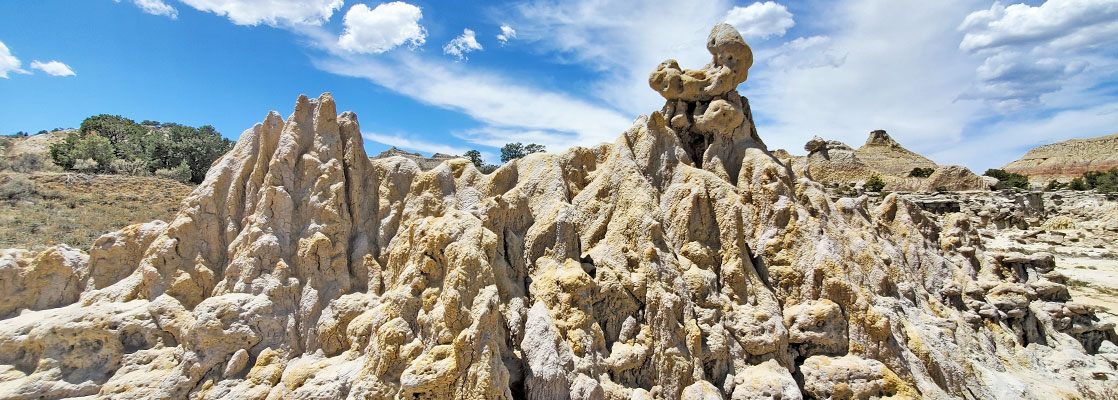
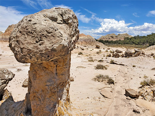
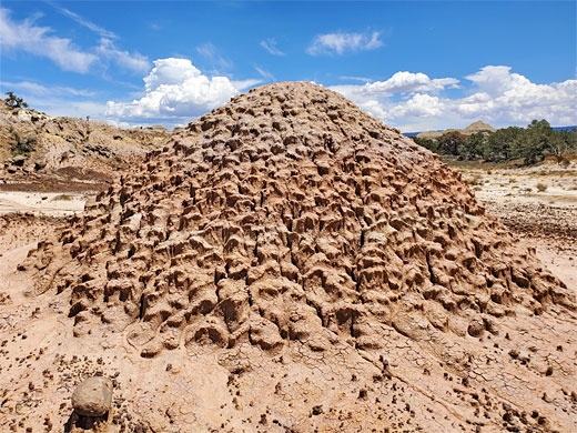
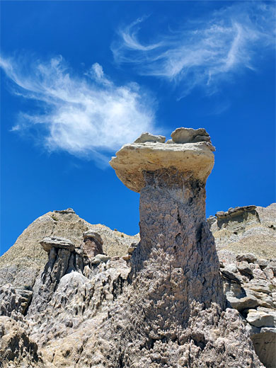
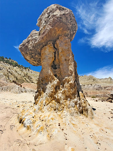
Unlike some other New Mexico Badlands, petrified wood and animal fossils are not found here, though the San Jose region does have all the other typical features including mounds, multicolored rocks, hoodoos and eroded formations, spread across an area approximately 3 miles from east to west and one mile north to south.
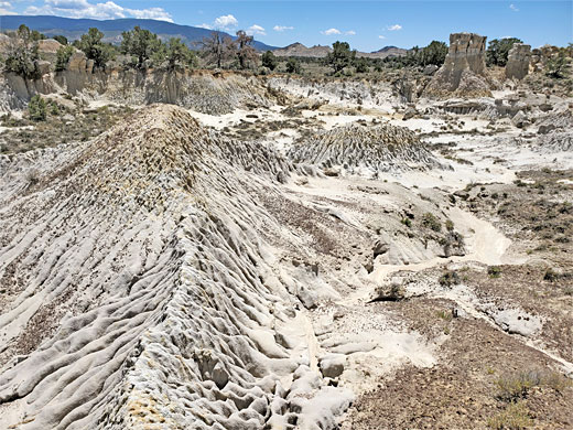
The landscape is not especially distinctive, with larger hoodoos few in number; much of the land is a jumbled array of slopes, low cliffs, loose rocks and small hoodoos, party vegetated, so not so not as impressive as other places like Bisti, As-Shi-Sle Pah or Lybrook. The place is very little visited yet easy enough to reach and explore owing to the generally low relief terrain; about half a day is enough to see all sections. Most of the land is pale-colored and can feel very hot in the sun, the light particularly bright and intense.
Unlike some other New Mexico Badlands, petrified wood and animal fossils are not found here, though the San Jose region does have all the other typical features including mounds, multicolored rocks, hoodoos and eroded formations, spread across an area approximately 3 miles from east to west and one mile north to south.
The landscape is not especially distinctive, with larger hoodoos few in number; much of the land is a jumbled array of slopes, low cliffs, loose rocks and small hoodoos, party vegetated, so not so not as impressive as other places like Bisti, As-Shi-Sle Pah or Lybrook. The place is very little visited yet easy enough to reach and explore owing to the generally low relief terrain; about half a day is enough to see all sections. Most of the land is pale-colored and can feel very hot in the sun, the light particularly bright and intense.
San Jose Badlands Table of Contents
Location
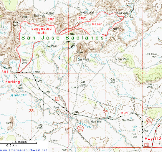
Map of badlands in the San Juan Basin.
Photographs
23 views of the San Jose Badlands.
Access to the San Jose Badlands
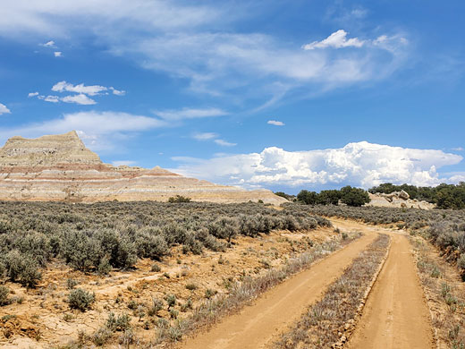
The San Jose Badlands are reached by driving 2.5 miles along (unpaved) County Road 391 (previously 74), which leaves Hwy 112 5.5 miles north of the settlement of Regina - west a short distance, round a bend to the north, past a house then west again, the surface rather stony, becoming smoother as the track crosses a dry wash, later bearing left at a junction and approaching an eroded ridge, this at the west end of the badlands. Parking is somewhere along the roadside, or at the end of a short side track to a drilling installation; like many of the New Mexico badlands, there are numerous gas wells in the vicinity.
Formations
The nearby ridge is a spur, stretching northwards from the approach road and meeting a larger west-east ridge; this extends about 2.5 miles eastwards, interrupted by a few gaps. The formations are found along the south or east side of these ridges, initially as a fairly narrow band but more extensive in the eastern half, where the ridge overlooks a broad, shallow basin, with more formations along its southern side. A typical exploration involves a loop walk of around 5 miles, returning along one of the gas well tracks.
West Badlands
Beyond the end of the track to the nearest gas well is a little ridge and then a scalloped north-trending slope of a half a mile, lined by scattered hoodoos and balanced rocks. Walking is easy along the level ground below, perhaps climbing up a little way on occasions to inspect particular formations. The ridgeline turns east, and the scenery is similar for another 0.8 miles. A gap at one point allows views over the wide flat land to the north, bordered to the far side, one mile away, by a line of cliffs, at the edge of a lengthy mesa along the continental divide.
East Badlands
The land becomes less rocky, mostly just smooth shale mounds in muted, banded colors, and it slopes down to a track which drops down further and exits the badlands to the dusty plain beyond, scattered across which are more gas wells. This point is about halfway through the badlands; further east is the shallow basin, with low cliffs to the north and south, and a branched dry wash across the center. Here are found a few larger hoodoos and other little peaks, amongst a generally more irregular landscape which takes longer to explore due to various little cliffs and gullies.
San Jose Badlands - Nearby Places
- Jemez Mountains (34 miles) - forested, volcanic mountains
- Penistaja Mesa (37 miles) - grey badlands, rock formations and petrified wood
San Jose Badlands - Similar Places
- Ah-Shi-Sle-Pah, New Mexico - hoodoos, badlands and other eroded rocks
- Angel Peak Scenic Area, New Mexico - pastel-colored cliffs and badlands, with occasional hoodoos
All Contents © Copyright The American Southwest | Comments and Questions | Contribute | Affiliate Marketing Disclosure | Site Map