Highlights:
Large badland region spanning over 700 feet of elevation; tall cliffs of brownish sandstone above extensive flats of lighter-colored rocks, crossed by branched ravines, with many fine hoodoos
Nearby town:
Bloomfield, 44 miles
Management:
BLM
Location:
36.178, -107.606 (southern trailhead)
Seasons:
All year, when dry, since the approach road may be impassable if wet
Rating (1-5):
★★★★★

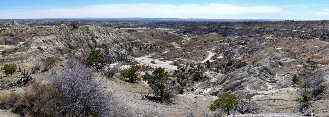
The Lybrook Badlands are amongst the largest of over a dozen badland regions of northwestern New Mexico, the majority within the San Juan Basin, extending in an arc nearly ten miles across, either side of US 550 between the villages of Nageezi and Counselor. Most is south of the highway, which runs for several miles near the edge of a plateau, elevation up to 7,300 feet; the land extends a little further south before breaking up to a series of short ravines and tall cliffs, up to 300 feet high, and across here are found many scattered formations including plenty of hoodoos, formed of light brown sandstone.
The main area of formations though is further south, across the wide valley floor beneath the cliffs, drained by many shallow branches of two seasonal drainages, Betonnie Tsosie Wash to the west and Alamito Arroyo to the south, a tributary of Escavada Wash. Beyond, to the southwest, the badlands are bordered by several lesser plateaus, lower in elevation, and edged by less steep slopes.
The main area of formations though is further south, across the wide valley floor beneath the cliffs, drained by many shallow branches of two seasonal drainages, Betonnie Tsosie Wash to the west and Alamito Arroyo to the south, a tributary of Escavada Wash. Beyond, to the southwest, the badlands are bordered by several lesser plateaus, lower in elevation, and edged by less steep slopes.
Lybrook Badlands Table of Contents
Access Routes to the Lybrook Badlands
Photographs
50 views of the Lybrook Badlands.
Introduction
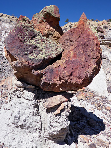
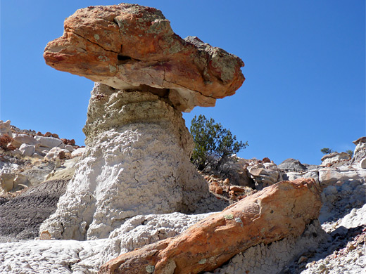
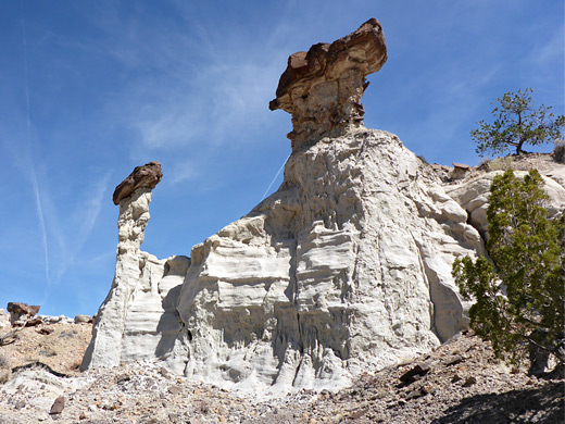
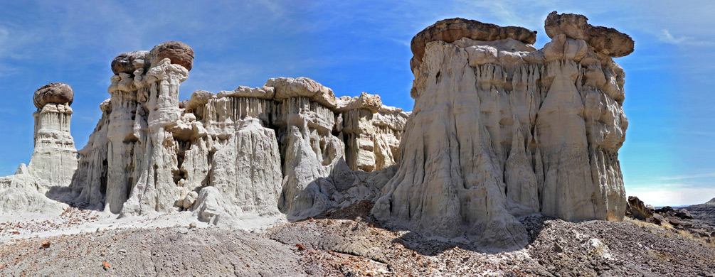
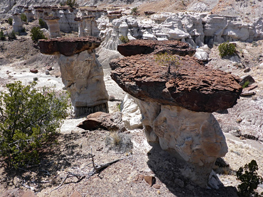
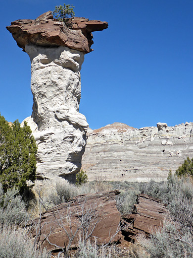
There are several overlooks of the badlands reached by short tracks off US 550, and although rather steep it is possible to climb down in some places and explore the upper level formations, but most visitors enter from the south since access is much easier. Here, the rocks are mostly white or pale grey, soft layers from the Naciemento formation, mixed with some narrower, darker strata of harder sandstone which form the caprock for many of the hoodoos and ridges. Like most such badlands, photogenic formations are not scattered evenly over the region, but rather found only in certain places, and it may take some time to discover the best areas.
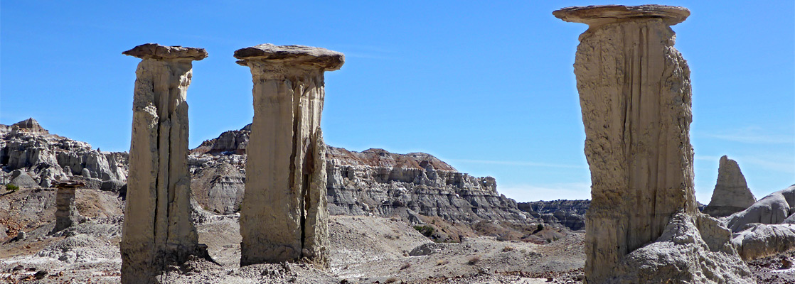
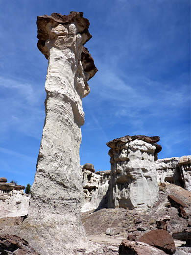
There are no paths or recognised hiking routes in the badlands, though cross-country travel is aided by a network of vehicle tracks across much of the area, constructed as part of extensive oil and gas operations in this part of the state. Although the relief is for most part fairly low, with peaks and ridges in the range of 50 to 200 feet, it can be quite hard to locate good routes over some of the hills. Compared to other regions like Bisti and De-Na-Zin, the hoodoos tend to be larger, taller and thicker, with less variation in color and form.
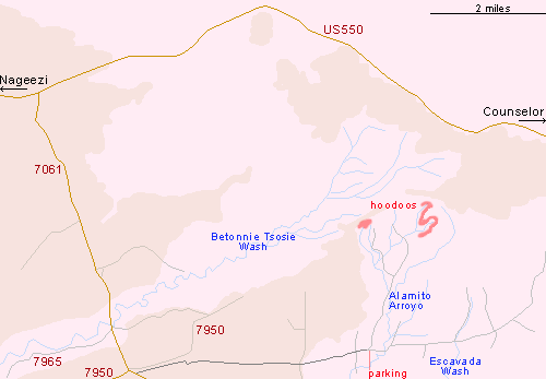
Lybrook Badlands Access
The Lybrook Badlands are managed by the BLM and are also known as the Lybrook Fossil Area, since fossils of trees, leaves and animals have all been found here. The most used access route is 5.1 miles south of US 550 along paved IR 7061, just past a junction to the west with road 7950 (leading to Chaco Culture NHS), then turning east along an unpaved track which crosses clayish ground that becomes impassable when wet but is smooth and firm when dry. The road passes several oil and gas installations, then after 2.9 miles reaches the brink of a line of low cliffs, descending 150 feet into the badlands. A suitable parking place is 1.7 miles further, beside a side track to the north, opposite a small pond and shortly before the crossing of Alamito Arroyo. Other tracks branch out to the north, east and south, leading to many more installations, positioned ever half mile or so, and the main track is quite heavily travelled by large trucks.
Locations
Much of the land is rather drab and dusty, parched of color and only lightly covered by vegetation; a mix of clayish flats, dry washes and low, grey mounds. The best of the rockier formations are concentrated in a band two miles north, with two specific locations of interest, a closely-spaced group at the head of a little valley towards the west, known informally as Hoodooville, and a more dispersed collection one mile east, around the upper ends of several small drainages. Both can be explored via a cross-country hike of about 8 miles.
Lybrook Badlands Hiking Route
The western group of hoodoos are easily reached by walking from the parking place up the side track; over a wash (Alamito Arroyo) after 1 mile, left at a junction soon after and past one gas plant after 2 miles, beyond which the road continues a little way further to a second. The hoodoos are reached by leaving the road next to the first installation, aiming for the furthest of several little washes, right beneath the cliffs of the plateau crossed by the access road. The formations are arranged around the upper end of the wash, in a U-shaped band, below a projecting ridge that extends east from the plateau. The main hoodoos have white pedestals topped by brown or orange caprocks, and some are up to 20 feet tall. To the east are more washes, generally without much of interest, separated by ridges that may be a little difficult to cross; the easiest continuation route seems to be up to the ridgeline to the north then along this eastwards until it slopes steeply down to a much wider valley. The ridge also gives fine views over all the badlands, north to the tall cliffs below US 550 and over countless mounds and ravines in all directions. Also in view is the second main hoodoo area, spreading across several side ravines east of the wash through the valley, and reached in another 15 minutes of walking. There are dozens of tall, shapely formations hereabouts, some isolated, others in groups, and several hours could be spent exploring. Above, further east, is steeper terrain rising up to 250 feet to a narrow, undulating ridge, the slopes of which are sprinkled with other hoodoos, generally smaller and harder to reach. The return route is downstream along any of the little dry washes, eventually intersecting an old vehicle track that later meets the main entry route, one mile from the start.
Lybrook Badlands - Nearby Places
- Angel Peak Scenic Area (40 miles) - small summit above pastel-colored cliffs and badlands
- Ceja Pelon Mesa (35 miles) - grey-black badlands and petrified wood
Lybrook Badlands - Similar Places
- Ah-Shi-Sle-Pah, New Mexico - hoodoos, badlands and other eroded rocks
- Coal Mine Canyon, Arizona - spires and multicolored rock on the Navajo Reservation
All Contents © Copyright The American Southwest | Comments and Questions | Contribute | Affiliate Marketing Disclosure | Site Map