Highlights:
Very scenic, steep and winding road through the White Mountains, part of a longer route (US 191) that passes other interesting sites including a huge mine, a playa and a lake-based state park
Nearby town:
Management:
BLM, USFS and private ownership
Location:
33.051, -109.29 (Clifton), 34.133, -109.280 (Springerville)
Seasons:
The road is open all year but the mountains receive heavy snowfall in winter
Rating (1-5):
★★★★★

The Spaniard Francisco Vásquez de Coronado became the first known European to lead an expedition into the USA when, in 1540, he and a large group of settlers crossed the Mexican border near the Huachuca Mountains, site of the present day Coronado National Memorial. From here they headed northeast, over the White Mountains in the east of the state and then, after side trips to Hopi land and the Grand Canyon, continued through New Mexico and into Kansas.
Their route through Arizona coincides largely with US 191 (formerly US 666), and the 123 mile section between Clifton and Springerville is named as the Coronado Trail to commemorate the exploration, though as with the national memorial there is no visible trace of the expedition. Instead the route, or indeed all of US 191, is a showcase for the varied and spectacular scenery of eastern Arizona, from the Sonoran Desert grasslands and valleys of the southeast corner, across the steep and heavily wooded White Mountains, down into the more barren lava fields and red plains of the Petrified Forest region and finally into the sandy expanses of the Navajo Indian Reservation.
Their route through Arizona coincides largely with US 191 (formerly US 666), and the 123 mile section between Clifton and Springerville is named as the Coronado Trail to commemorate the exploration, though as with the national memorial there is no visible trace of the expedition. Instead the route, or indeed all of US 191, is a showcase for the varied and spectacular scenery of eastern Arizona, from the Sonoran Desert grasslands and valleys of the southeast corner, across the steep and heavily wooded White Mountains, down into the more barren lava fields and red plains of the Petrified Forest region and finally into the sandy expanses of the Navajo Indian Reservation.
Coronado Trail Table of Contents
The South
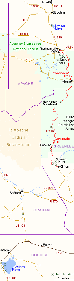
From the Huachuca Mountains, Coronado traveled up the San Pedro River Valley and headed northeast, probably crossing the Dragoon Mountains close to where I-10 cuts though today. Just east of the mountains, the interstate is joined from the south by US 191 which thereafter marks the approximate route taken by the Spanish expedition. The first point of interest is the largest dry lake bed in Arizona - 200 square mile Willcox Playa, a National Natural Landmark, best viewed by driving south on US 191 a few miles. This is a vast expanse of dry mud, ringed by a white band of salt deposits and completely without vegetation. The top corner is crossed by tracks of the Union Pacific Railroad, part of a dead straight stretch of over 20 miles.
San Simon Valley, Safford, and Mines at Clifton
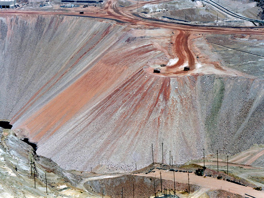
Ten miles beyond Willcox, US 191 parts company with I-10 and heads due north, 25 miles across the very wide, empty, cacti-covered plain of the San Simon Valley to Safford, then changes in character as the road becomes narrower and winding, through the Peloncillo Mountains, which are made of dark rocks in varying forms and colors, a hint of the interesting geology that lies beneath, and reflecting increased mineralization that culminates in the historic mining town of Clifton. This is another small settlement with many old buildings dating from the nineteenth century, and is also the terminus of a branch of the Union Pacific Railroad, all built in quite a narrow canyon, dwarfed by huge tailings piles from mines in the surrounding hills. North of Clifton, the road, now officially designated the Coronado Trail, is less traveled and climbs quite steeply, past more mining activity, through a small tunnel and past various abandoned buildings then into a region of even greater excavation - this is the amazing Morenci Mine, a vast copper operation run by the Phelps Dodge Corporation where many acres of the hills have been dug out to great depths, revealing rock strata of varied colors. A roadside overlook high above gives a fine view of current activities, looking town on army of rock-moving Caterpillar trucks that seem tiny from a distance but actually can carry over 200 tons. The course of the road in this area seems transient, as if it is moved depending on which part is being excavated.
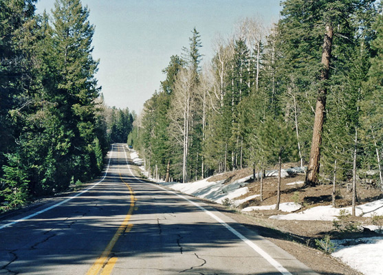
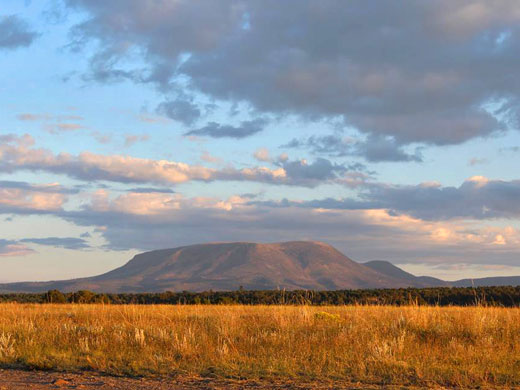
Mountains along the Coronado Trail
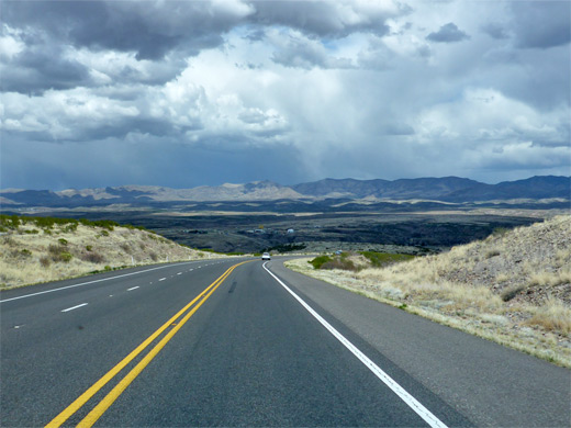
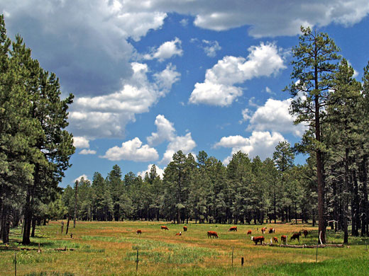
Beyond the mine, US 191 follows the steep-sided valley of Chase Creek, up switchbacks at the northern end then continues to climb steadily, though mixed woodland at first and later into dense pine forests - uneven land which forces many 10 mph bends and steep gradients, and the road remains so for the next 50 miles, as it crosses the east side of the White Mountains. The road passes various campgrounds, trailheads, viewpoints, forest tracks, picnic areas and occasional flat meadows like Four Bar Mesa, but most is very winding and often precipitous, with unfenced, steep drop-offs at the side. One summit is reached at Rose Peak (8,786 feet) but later the route climbs higher still, up to 9,300 feet as it reaches the Mogollon Rim, where winter snows linger until June. The seemingly endless woods harbor many animals, including a pack of Mexican gray wolves, which were reintroduced to the Blue Range area in 1998. At Hannagan Meadow, the road improves somewhat, becoming wider and less bendy, soon descending into slightly more gentle scenery at Alpine - a small town in a wide valley, though still over 8,000 feet. The mountains end not far north of here, as the trees are replaced by bushy plateaus and mesas and the road approaches the twin cities of Eagar and Springerville, at the end of the section designated Coronado Trail. One small section of the hills just south of Springerville is protected as Sipe White Mountain Wildlife Area, accessed by a short side road off US 191, and is popular for hiking, picnicking and wildlife viewing. North of Springerville, once past Lyman Lake reservoir (a state park), the landscape changes quite suddenly to open, arid grasslands with patches of lava, yet the road is still generally quiet and little-traveled, and remains so all the way to I-40, which it meets a little way east of Petrified Forest National Park.
All Contents © Copyright The American Southwest | Comments and Questions | Contribute | Affiliate Marketing Disclosure | Site Map