Puerco Pueblo Trail, Petrified Forest National Park
Arizona > Petrified Forest National Park > Hiking > Puerco Pueblo Trail

Puerco Pueblo Trail
Short loop around the site of an Ancestral Puebloan dwelling from the 1500s, once containing over a hundred rooms. Runs alongside the rim of a shallow canyon for a short distance, within sight of dozens of petroglyphs
Length: 0.3 miles
Elevation change: 15 feet
Difficulty: Easy
Type: Loop
Usage: High
Season: All year
Trailhead: Parking area along the main road
Rating (1-5): ★★★★★
Elevation change: 15 feet
Difficulty: Easy
Type: Loop
Usage: High
Season: All year
Trailhead: Parking area along the main road
Rating (1-5): ★★★★★

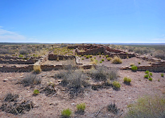
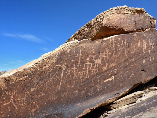
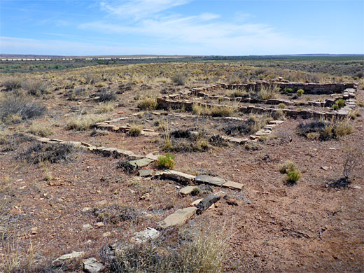
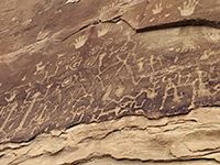
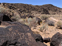
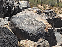
The Puerco Pueblo Trail in Petrified Forest National Park is a very short (0.3 mile) loop across flat land just south of the ATSF railway, around the site of an Ancestral Puebloan settlement from the 1300s, once containing over 100, single storey rooms, including several kivas, and home to maybe 250 people. On the south side of the pueblo the land breaks up into a line of huge boulders, at the rim of a shallow canyon, and many are adorned with petroglyphs, the designs particularly numerous and varied.
The hike is popular since it starts right beside the park road, at mile marker 11, and is fully paved and accessible. Also along the loop is a tiny museum, in a stone building once used as a check station for the park, before the boundaries were extended to include part of the Painted Desert to the north.
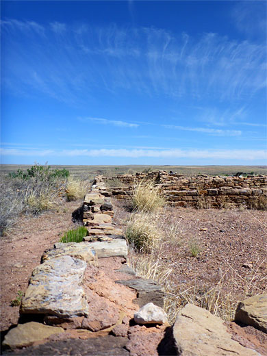
Visible relics are series of low walls, stabilised and partly restored, from maybe 20 rooms, though this is only a small section of the site, most of which is unexcavated and so appears only as featureless piles of overgrown rubble. The whole village is 250 feet by 150 feet in size, and it was first excavated in 1905, by John Muir.
The village is built on a low plateau just south of the Puerco River - a good water source for the Ancestral Puebloans, one that allowed for cultivation of crops on the surrounding floodplain, though not always reliable, and due to an extended period of drought, the pueblo was abandoned, around 1380.
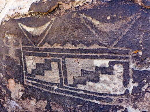
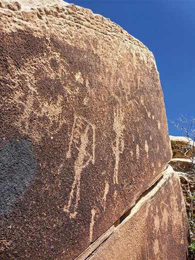
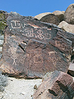
The Puerco Pueblo Trail starts from a good-sized parking lot, with restrooms. The path heads south and soon forks, the east branch entering the pueblo site, initially the unexcavated ruins, then passing round the edge of the restored part, an L-shaped sequence of room foundations. It curves to the west, past the historic check station, and returns to the initial junction. The many petroglyphs, over 800 of them, are below the southern section of the path, etched on the sides of large boulders, all composed of light brown sandstone from the Newspaper Rock bed of the Blue Mesa Member of the Chinle Formation. The specific name references another outcropping less than a mile south, centered on the huge slabs of Newspaper Rock, another petroglyph site. The rock art at the pueblo includes a solar marker, a small circular effigy in a normally shady crevice that is illuminated by the sun only for about two weeks either side of the summer solstice on June 21. Some of the designs are illustrated and interpreted on a series of notices along the path.
The hike is popular since it starts right beside the park road, at mile marker 11, and is fully paved and accessible. Also along the loop is a tiny museum, in a stone building once used as a check station for the park, before the boundaries were extended to include part of the Painted Desert to the north.
Visible relics are series of low walls, stabilised and partly restored, from maybe 20 rooms, though this is only a small section of the site, most of which is unexcavated and so appears only as featureless piles of overgrown rubble. The whole village is 250 feet by 150 feet in size, and it was first excavated in 1905, by John Muir.
The village is built on a low plateau just south of the Puerco River - a good water source for the Ancestral Puebloans, one that allowed for cultivation of crops on the surrounding floodplain, though not always reliable, and due to an extended period of drought, the pueblo was abandoned, around 1380.
The Loop Trail
The Puerco Pueblo Trail starts from a good-sized parking lot, with restrooms. The path heads south and soon forks, the east branch entering the pueblo site, initially the unexcavated ruins, then passing round the edge of the restored part, an L-shaped sequence of room foundations. It curves to the west, past the historic check station, and returns to the initial junction. The many petroglyphs, over 800 of them, are below the southern section of the path, etched on the sides of large boulders, all composed of light brown sandstone from the Newspaper Rock bed of the Blue Mesa Member of the Chinle Formation. The specific name references another outcropping less than a mile south, centered on the huge slabs of Newspaper Rock, another petroglyph site. The rock art at the pueblo includes a solar marker, a small circular effigy in a normally shady crevice that is illuminated by the sun only for about two weeks either side of the summer solstice on June 21. Some of the designs are illustrated and interpreted on a series of notices along the path.
Puerco Pueblo Trail - Similar Hikes
All Contents © Copyright The American Southwest | Comments and Questions | Contribute | Affiliate Marketing Disclosure | Site Map