Zion National Park is the premier hiking location in southwest Utah; many of the best routes are along narrow canyons, and more are found a little way south and east. Other destinations are Cedar Breaks National Monument and Snow Canyon State Park.
Map shows trailhead locations
1. Alpine Pond Trail, Cedar Breaks National Monument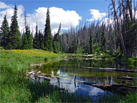 Length 2.2 miles (3.5 km); (loop) Elevation change 200 feet (61 meters) Difficulty Easy Rating (1-5) ★★★★★ This trail passes major no viewpoints of the eroded formations but instead encounters trees, meadows, flowers and wildlife en route to a tranquil pool fed by meting snow. A cut-off half way along enables a shorter loop, of just one mile |
2. Angels Landing Trail, Zion National Park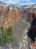 Length 2.5 miles (4 km) Elevation change 1500 feet (457 meters) Difficulty Moderate to strenuous Rating (1-5) ★★★★★ One of the most spectacular trails in any national park, the route to 5,785 foot Angels Landing climbs steeply up the cliffs on the west side of Zion Canyon for a panoramic view over the surrounding landscape. Most of the path is the lower end of the West Rim Trail; the Angels Landing Trail is a 0.5 mile spur to the summit. The path runs along a narrow ridge with sheer drops on either side, and chains are provided in some places to assist the ascent. |
3. Beartrap Canyon Length 8.8 miles (14.2 km); to the waterfall Elevation change 1000 feet (305 meters) Difficulty Moderate; no particular obstacles, but a long hike Rating (1-5) ★★★★★ Short but deep and very pretty narrows leading to a pool and waterfall; a remote tributary of La Verkin Creek, in the Kolob Canyons area of Zion National Park. Reached by the La Verkin Creek Trail, and part of the Willis Creek Trail. |
4. Bitter Creek Length 0.5 miles (0.8 km) Elevation change 240 feet (73 meters) Difficulty Moderate; a few obstacles to climb over Rating (1-5) ★★★★★ Short canyon draining the southern slopes of the Pine Valley Mountains, west of Zion NP, forming a quarter mile slot towards its lower end, enclosed by dark, grey or red rocks. The upper end has a few dryfalls requiring ropes, but most can be seen approaching from below. |
5. Cable Mountain Trail, Zion National Park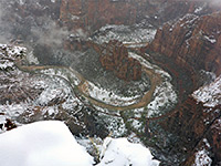 Length 2.5 miles (4 km) Elevation change 500 feet (152 meters) Difficulty Easy Rating (1-5) ★★★★★ The trail to the top of Cable Mountain, a less-visited alternative to Angels Landing and Observation Point for views of Zion Canyon, begins along the East Rim Trail 4.5 miles from its western end at Weeping Rock. The path is an easy traverse of wooded, gently hilly land, ending right at the edge of the sheer cliffs above Echo Canyon and the Virgin River; site of a short-lived cable system installed in 1901. The total elevation gain if starting from Zion Canyon is 2,600 feet. |
6. Canyon Overlook Trail, Zion National Park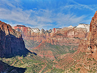 Length 0.5 miles (0.8 km) Elevation change 160 feet (49 meters) Difficulty Easy Rating (1-5) ★★★★★ This easy, popular path - the only official trail in the southeast section of Zion NP, along UT 9 - offers hikers a grand view down the deep valley of Pine Creek, which joins the Virgin River near the lower end of Zion Canyon. The route is through interesting, rocky scenery, past the upper end of the Pine Creek slot canyon. |
7. Chinle Trail, Zion National Park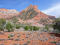 Length 8 miles (12.9 km); to Coalpits Wash Elevation change 650 feet (198 meters) Difficulty Moderate - long, and often hot, though not steep Rating (1-5) ★★★★★ The Chinle Trail is named after the predominant rock layer found along the way - the colorful Chinle Formation, and is also known as the Petrified Wood Trail on account of the small pieces of fossilized logs that may be found. The little used path crosses the low elevation southwest corner of Zion National Park, still in sight of high red and white cliffs to the north though passing across open, flattish land with bushes, cacti and yucca. The start point is along UT 9 south of Springdale, and the path ends besides Coalpits Wash, though continuation hikes up or down the wash are possible. |
8. Clear Creek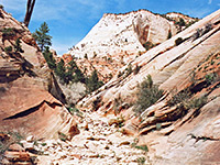 Length 0.5 miles (0.8 km); or longer Elevation change 50 feet (15 meters) Difficulty Easy Rating (1-5) ★★★★★ Long drainage on the east side of Zion National Park, running close to UT 9; not generally very enclosed, but forming good, short stretches of easily-accessed narrows. A dozen side canyons are worthy of exploration. |
9. Coalpits Wash, Zion National Park Length 8 miles (12.9 km); to the upper end of the narrows Elevation change 1000 feet (305 meters) Difficulty Moderate Rating (1-5) ★★★★★ Lengthy drainage in the low elevation southwest corner of the park, containing long sections of shallow, flowing water; followed by a trail that is initially quite well used, but fades away in the upper section, where the stream forms some pools, cascades and narrow channels. |
10. Eagle Crags and Lower Mountain, Zion National Park Length 5 miles (8 km); to the plateau rim Elevation change 1800 feet (549 meters) Difficulty Strenuous Rating (1-5) ★★★★★ The Eagle Crags are a group of sandstone pinnacles at the end of a ridge on the south side of the Virgin River, reached by a semi-maintained trail, ending at an impressive viewpoint. A much rougher route continues to the rim of Lower Mountain, an isolated plateau covered by eroded formations. |
11. East Mesa Trail, Zion National Park Length 4 miles (6.4 km) Elevation change 1000 feet (305 meters) Difficulty Moderate Rating (1-5) ★★★★★ The lower end of the East Mesa Trail forms part of the popular route to Observation Point and is also used to reach Mystery Canyon, a mile to the north. Beyond here the path is less used, as it bends eastwards and crosses wooded land, exiting the park and meeting a rough vehicle track that links with the Chamberlain Ranch Road. The other end is along the East Rim Trail in Echo Canyon, from where the path switchbacks up the rocky slopes to a forested mesa then is mostly level. The turn-off for Observation Point is reached after 1.5 miles. |
12. East Rim Trail, Zion National Park Length 10.5 miles (16.9 km) Elevation change 2600 feet (792 meters) Difficulty Strenuous Rating (1-5) ★★★★★ The East Rim Trail is a candidate for the best hiking path in Zion National Park, passing varied scenery of high mountains, narrow canyons, forests and meadows. The east end is along UT 9 next to the east entrance station while the west end is at the Weeping Rock parking area along the scenic drive through Zion Canyon. En route are several junctions, with the Cable Mountain, Observation Point, East Mesa and Hidden Canyon trails. |
13. Echo Canyon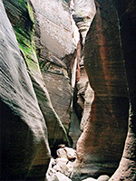 Length 1.6 miles (2.6 km); to the last rappel point when descending from above Elevation change 1100 feet (335 meters) Difficulty Moderate; dryfalls and pools Rating (1-5) ★★★★★ Spectacular deep and dark slot canyon with extravagantly sculptured walls, tinged with green moss in many places. The lower half is accessible by walking in from below; the full canyon needs ropes to explore, starting from the top. |
14. Elkhart Cliffs Canyon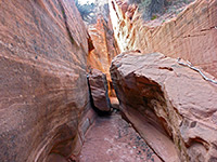 Length 0.7 miles (1.1 km); to the upper end of the narrows Elevation change 300 feet (91 meters) Difficulty Easy Rating (1-5) ★★★★★ Very short slot canyon along an unnamed wash draining the south end of the Elkhart Cliffs; nice passages through stripy rocks, plus a few dryfalls, potholes and possible pools. Also known as Diana's Throne Canyon |
15. Emerald Pools Trail, Zion National Park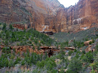 Length 1.5 miles (2.4 km); to the upper pool Elevation change 350 feet (107 meters) Difficulty Easy Rating (1-5) ★★★★★ Another of the more popular paths in Zion Canyon is the route to the upper, middle and lower Emerald Pools - three pretty ponds beneath sheer sandstone cliffs, formed by seasonal streams that flow from Heaps and Behunin canyons high above. Beside the pools, the trail offers nice views up and down the Virgin River Valley, and of the cliffs opposite, including Great White Throne and Red Arch Mountain. There are two separate trails to the ponds, and a third route (the Kayenta Trail) links the pools with the West Rim Trail a short distance north. |
16. Hidden Canyon Trail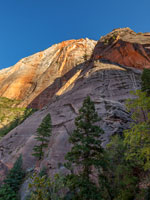 Length 1.1 miles (1.8 km) Elevation change 800 feet (244 meters) Difficulty Easy to moderate; several short climbs beyond the official path, which en route traverses a steep cliff with the aid of chains Rating (1-5) ★★★★★ The lower end of the cool, shady narrows of Hidden Canyon may be reached by a short though quite strenuous trail, part of which involves a traverse of a sheer cliff face with the aid of chains. Dryfalls and other confined sections can be seen by hiking and scrambling further upstream, off trail. |
17. Kanarra Creek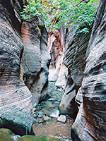 Length 2.9 miles (4.7 km); to the upper end of the narrows Elevation change 800 feet (244 meters) Difficulty Moderate; some deep pools to wade and several large chokestones to climb, using improvised ladders Rating (1-5) ★★★★★ Beautiful, deep and narrow red rock canyon containing a permanent stream, fairly shallow for most of the year, forming pretty pools, waterfalls and flooded channels. |
18. Keyhole Canyon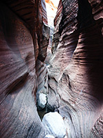 Length 1.2 miles (1.9 km); round trip, to see the hikeable parts of the canyon Elevation change 120 feet (37 meters) Difficulty Easy to moderate; various chokestones to climb over Rating (1-5) ★★★★★ Minor drainage on the north side of Clear Creek, containing three narrows sections; shallow upper passages, a short enclosed middle with several moderate obstacles, then a dark slot through reddish black sandstone, where ropes are needed in three places. The canyon is considered to be the best place in the national park to learn or practice rappelling techniques. Most can be seen via hiking, however. |
19. Kolob Arch Trail, Zion National Park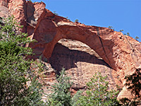 Length 0.6 miles (1 km) Elevation change 150 feet (46 meters) Difficulty Easy, though with a long approach Rating (1-5) ★★★★★ The short spur path to Kolob Arch begins along the La Verkin Creek Trail - a short walk up a tributary of the creek to a viewpoint beneath the arch, which is one of the largest in the world with a span of 287 feet. The arch is 6.5 miles from the Lee Pass trailhead on the Kolob Canyons road, so can be reached on a day hike. |
20. Kolob Creek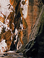 Length 2.6 miles (4.2 km); to the creek, which can then be followed upstream or downstream Elevation change 1800 feet (549 meters) Difficulty Moderate to strenuous - steep, off trail approach, followed by wading in the creek and climbing obstacles Rating (1-5) ★★★★★ Major tributary of the Virgin River, flowing through a deep, long slot canyon. Very challenging to explore fully as the upper end has many deep pools and sheer drops, but the lower narrows can be reached by quite a steep hike. |
21. La Verkin Creek Trail, Zion National Park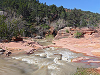 Length 11.5 miles (18.5 km) Elevation change 1200 feet (366 meters) Difficulty Strenuous Rating (1-5) ★★★★★ This lengthy backcountry route begins at Lee Pass, about half way along the paved Kolob Canyons Road. It follows the wooded valley of Timber Creek southwards, beneath the towering cliffs that characterize this section of the park, then turns east along the larger drainage of La Verkin Creek. 6.5 miles from the start is the turn-off for the short path to Kolob Arch, then soon after is another junction, with the Hop Valley Trail. The main path, now less used, continues eastwards through a narrowing, overgrown canyon, then up the tributary gorge of Willis Creek as far as the park boundary. Although a trail goes on and eventually meets the Kolob Reservoir, it crosses private land to which access is currently closed. |
22. Lava Flow Trail, Snow Canyon State Park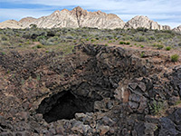 Length 1.1 miles (1.8 km) Elevation change 420 feet (128 meters) Difficulty Easy Rating (1-5) ★★★★★ This trail links the paved scenic drive with the unpaved West Canyon Road. The eastern half is busiest, crossing black lava deposits past at least two lava caves, to a junction with the Butterfly Trail and also with the short spur to West Canyon Overlook, a popular viewpoint that has a panoramic vista over all of the state park. Beyond here, the path descends quite steeply down bushy slopes, to the floor of Snow Canyon. |
23. Mineral Gulch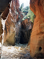 Length 6.6 miles (10.6 km); to the Virgin River, from the 2WD parking area Elevation change 1200 feet (366 meters) Difficulty Easy to moderate; no great obstacles, but a long hike Rating (1-5) ★★★★★ Remote, secluded canyon, a tributary of the East Fork of the Virgin River, joining just after a fairly short but scenic and quite deep slot canyon section through dark red sandstone. |
24. Misery Canyon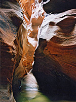 Length 9 miles (14.5 km); round trip Elevation change 1400 feet (427 meters) Difficulty Moderate; several obstacles in the upper slots but all can be bypassed. Steep descent to the river Rating (1-5) ★★★★★ Mostly shallow drainage of two branches, forming short slots between longer open sections, ending with a 30 foot dryfall into a much deeper and darker canyon, which joins the East Fork of the Virgin River. The lower end is very pretty and usually contains a small stream; hikers may enter from below after a steep descent to the river. 9 miles is the round trip distance to see the accessible parts of the upper canyon, descend the bypass route to the lower end, then return to the trailhead. |
25. North Creek, Left Fork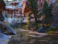 Length 3.4 miles (5.5 km); to the Subway Elevation change 1200 feet (366 meters) Difficulty Easy to moderate; obstacles begin just above the Subway Rating (1-5) ★★★★★ Popular, oft-visited narrow canyon that includes The Subway, where the creek flows through a long, tubular passage with only a narrow opening above. Further upstream are deep pools and drop-offs that may be seen (with use of ropes) if starting from an alternative trailhead, but most just explore the lower narrows. |
26. Northgate Peaks Trail, Zion National Park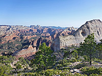 Length 2 miles (3.2 km); to the promontory Elevation change 100 feet (30 meters) Difficulty Easy; moderate if ascending a peak Rating (1-5) ★★★★★ The Northgate Peaks are a pair of rounded, smooth-sided summits at the edge of Pine Valley, along the Kolob Reservoir Road. An easy trail crosses the forested valley to a viewpoint between the peaks of cliffs and canyons to the south, including the Left Fork of North Creek. The summits can be climbed, for even better views; the easternmost is easier. |
27. Observation Point Trail, Zion National Park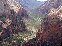 Length 4 miles (6.4 km) Elevation change 2150 feet (655 meters) Difficulty Strenuous Rating (1-5) ★★★★★ The actual Observation Point Trail is only 0.25 miles long - a spur off the East Mesa Trail - though the hike to the viewpoint is a 4 mile trip beginning at Weeping Rock on the floor of Zion Canyon. The first part of the route is the same as for Echo Canyon, followed by an steep ascent above the canyon to the plateau (on the East Mesa Trail), then the short walk west to the 6,508 foot viewpoint. This rivals Angels Landing on the opposite side of the canyon for the best views in the park. |
28. Orderville Canyon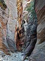 Length 8.4 miles (13.5 km); to Zion Canyon Elevation change 1700 feet (518 meters) Difficulty Moderate - pools and chokestones towards the lower end Rating (1-5) ★★★★★ Spectacular, long and very deep gorge joining the Zion Narrows. The lower 3 miles are most impressive, and part contains a permanent stream, with pools, waterfalls and several huge chokestones. |
29. Pa'rus Trail, Zion National Park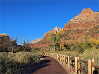 Length 1.7 miles (2.7 km) Elevation change 40 feet (12 meters) Difficulty Easy Rating (1-5) ★★★★★ The paved Pa'rus Trail (built 1995) runs alongside the Virgin River, mostly on the east side, between Zion Canyon Visitor Center and Canyon Junction. The surroundings are grassy meadows with cottonwoods, bushes and yucca, surrounded by the high red cliffs of the canyon. Hikers share the path with cyclists, and it is also well suited for wheelchairs. |
30. Parunuweap Canyon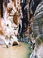 Length 3.9 miles (6.3 km); to the river Elevation change 1400 feet (427 meters) Difficulty Moderate; route finding on the approach, wading in the river and a climbing few obstacles Rating (1-5) ★★★★★ Typically deep and narrow Zion canyon, formed by the East Fork of the Virgin River, very similar to the famous Zion Narrows but harder to reach. The section within the national park is closed to all hikers, but the lengthy narrows further east are accessible; one day hike destination is Poverty Wash, 6.7 miles upstream |
31. Pine Creek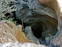 Length 0.4 miles (0.6 km); for the start of the slot and the upstream narrows Elevation change 40 feet (12 meters) Difficulty Easy, for the hiking Rating (1-5) ★★★★★ Most popular of Zion's technical slot canyons, deepening rapidly via chokestones and dryfalls that require rappels of up to 60 feet. Hikers may see the very beginning of the slot, and a short narrows section further upstream. |
32. Poverty Wash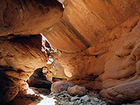 Length 9 miles (14.5 km); from the 4WD road to the Virgin River Elevation change 1200 feet (366 meters) Difficulty Moderate - a long hike to reach the canyon, and various minor obstacles to overcome Rating (1-5) ★★★★★ Hard to reach tributary of Parunuweap Canyon - short stretches of colorful narrows between wider parts, before a 40 foot dryfall and a rather darker and more impressive slot, which gives way to a pleasant gorge containing a small stream. This soon meets the main canyon, close to several other narrow tributaries. |
33. Rattlesnake Creek Trail, Cedar Breaks National Monument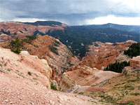 Length 3.8 miles (6.1 km); to the canyon floor Elevation change 2400 feet (732 meters) Difficulty Moderate Rating (1-5) ★★★★★ Lightly-used trail past two viewpoints on the rim of Cedar Breaks then steeply down through meadows and pine/aspen forest into a thickly wooded canyon containing a permanent stream, within the Ashdown Gorge Wilderness. Wildflowers are abundant along the path, especially the upper part |
34. Red Canyon (Peek-a-Boo Canyon)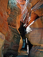 Length 4.5 miles (7.2 km); to the dryfall, via the sandy track Elevation change 450 feet (137 meters) Difficulty Easy. One blocking chokestone near the upper end Rating (1-5) ★★★★★ Half a mile of colorful, medium depth narrows along a minor tributary of Kanab Creek, surrounded by a rolling landscape of sand dunes and small hills. |
35. Red Hollow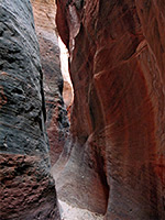 Length 0.6 miles (1 km) Elevation change 200 feet (61 meters) Difficulty Easy, to the obstructions Rating (1-5) ★★★★★ Red Hollow, east of Orderville, has narrow, vertical-walled passages through deep red rocks, most of which is hikeable from the lower end though an unclimbable dryfall means that the full length can only be explored from above, using ropes. The lower canyon lacks any overhanging rocks so the passageways are well lit, but not particularly distinctive as the rock is uniform in texture and grey/dark red in color. |
36. Red Reef Trail, Red Cliffs Recreation Area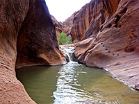 Length 1 mile (1.6 km); or more Elevation change 80 feet (24 meters) Difficulty Moderate; various obstacles to pass Rating (1-5) ★★★★★ Starting beside the park campground, a short path follows the year round stream of Quail Creek to the first point where water covers all the canyon floor. The drainage can then be followed further, past dramatic red cliffs, by a combination of wading, scrambling up small waterfalls and walking along sand banks. |
37. Right Fork of North Creek, Zion National Park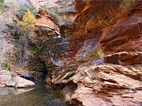 Length 5.8 miles (9.3 km) Elevation change 900 feet (274 meters) Difficulty Moderate to strenuous Rating (1-5) ★★★★★ Lower portion of a lengthy drainage that narrows gradually to a deep, enclosed section with many waterfalls, pools and boulders, to the larger Barrier Falls, which is impassable from below |
38. Sand Bench Trail, Zion National Park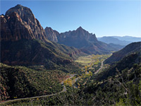 Length 4.6 miles (7.4 km); (loop) Elevation change 500 feet (152 meters) Difficulty Easy Rating (1-5) ★★★★★ The Sand Bench trail loops around a partly bushy, partly open plateau beneath The Sentinel on the west side of the Virgin River, and offers impressive views of the surrounding cliffs. The trailhead is at the end of a short side road next to Birch Creek and the Court of the Patriarchs. The path is mostly used by horses. |
39. Sand Wash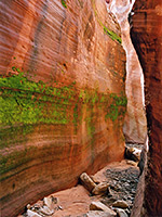 Length 8 miles (12.9 km); round trip for a loop through the accessible parts of both canyons Elevation change 800 feet (244 meters) Difficulty Moderate to strenuous; dryfalls, pools and chokestones Rating (1-5) ★★★★★ Branched drainage beneath the Elkheart Cliffs, east of Zion NP; a sandy wash for most of its length, but forming two good slot sections through richly colored rocks. Both have obstructions and one needs ropes to descend fully but most can be seen by regular hiking, exiting and re-entering to avoid obstacles. |
40. Spectra Point/Ramparts Overlook Trail, Cedar Breaks National Monument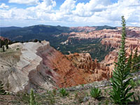 Length 2.6 miles (4.2 km); to the Bartizan Elevation change 850 feet (259 meters) Difficulty Moderate Rating (1-5) ★★★★★ Gently descending path along the rim, past a promontory to a second viewpoint. An unofficial, off-trail continuation leads to a stream with waterfall, and another, more exposed promontory (The Bartizan), containing several arches |
41. Spring Creek Canyon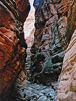 Length 3 miles (4.8 km); to Sweetwater Gulch Elevation change 1000 feet (305 meters) Difficulty Easy Rating (1-5) ★★★★★ Conspicuous valley just north of Zion National Park, sheer-walled for over a mile, through colorful red rocks. Not especially narrow but quite pretty, and with several short side canyons. A small stream flows through most of the year, forming many tiny pools and cascades. |
42. Spring Hollow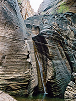 Length 0.5 miles (0.8 km) Elevation change 100 feet (30 meters) Difficulty Easy, to the waterfall Rating (1-5) ★★★★★ Spring Hollow contains a short narrows section, usually with a shallow stream flowing through, that ends in an enclosed chamber where the water falls 20 feet into a shallow pool, cascading down a wall of horizontal, thin-layered strata; a photogenic scene. |
43. Taylor Creek, Middle Fork Length 3.1 miles (5 km); to where the canyon becomes steep and narrow Elevation change 700 feet (213 meters) Difficulty Easy - a maintained trail leads to the alcove Rating (1-5) ★★★★★ Most enclosed of the Finger Canyons of the Kolob; a narrowing, vegetation-filled valley containing a small stream, eventually becoming sheer sided, though gaining height steeply via boulders and falls. Also contains Double Arch Alcove, a colorful eroded cavity. |
44. Taylor Creek, South Fork, Zion National Park Length 1 mile (1.6 km) Elevation change 200 feet (61 meters) Difficulty Easy Rating (1-5) ★★★★★ Path along the floor of a narrowing, riparian canyon containing much vegetation and a variety of wildlife. The upper end becomes deep and enclosed, gaining height via dryfalls and boulders |
45. Tempi'po'op Trail, Santa Clara River Reserve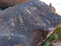 Length 1 mile (1.6 km) Elevation change 300 feet (91 meters) Difficulty Easy Rating (1-5) ★★★★★ Path up a sloping plateau beside the Santa Clara River to an extensive group of petroglyphs along the rim, on large, dark-colored boulders. The top of the high ground is formed of an even layer of erosion-resistant conglomerate, lying on top of the upper red member of the Moenkopi Formation, which is exposed most extensively on the cliffs bordering the east side of the river. |
46. Three Ponds Trail, Snow Canyon State Park Length 1.8 miles (2.9 km) Elevation change 110 feet (34 meters) Difficulty Easy to moderate - some soft sand Rating (1-5) ★★★★★ Varied route that winds through little ravines and sandstone ridges then descends to the main valley floor, crossing Snow Canyon wash and continuing up a sandy tributary drainage to a very short slot canyon, containing seasonal pools. Above is a short stretch of more enclosed canyon ending at a high dryfall. Also known as the Red Sands Trail. |
47. Watchman Trail, Zion National Park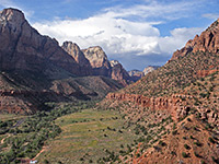 Length 1.4 miles (2.3 km) Elevation change 450 feet (137 meters) Difficulty Easy Rating (1-5) ★★★★★ From the Zion Canyon Visitor Center near Watchman Campground, this path climbs into a small ravine then bends back westwards to a promontory overlooking the Virgin River valley. There is no shade along the path so it can be hot in summer. The viewpoint has excellent views over nearby peaks including Bridge Mountain, the West Temple and the distinctive spire of the Watchman. |
48. Water Canyon Length 2 miles (3.2 km); to the edge of the mountain plateau Elevation change 1200 feet (366 meters) Difficulty Easy to moderate, depending on the amount of off-trail exploration Rating (1-5) ★★★★★ Relatively short but steeply-descending canyon on the south side of Canaan Mountain, containing a permanent stream that forms beautiful waterfalls, clear pools and slot-like passageways. Accessed by a well used trail that continues above the canyon to a slickrock wilderness on the mountain top. |
49. Weeping Rock Trail, Zion National Park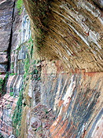 Length 0.25 miles (0.4 km) Elevation change 60 feet (18 meters) Difficulty Easy, paved route Rating (1-5) ★★★★★ Weeping Rock is one of Zion's most photographed places - a curved cliff face that continually seeps water at the junction of two sandstone strata (the Kayenta and Navajo layers), sustaining a curtain of ferns, moss and wildflowers. The short, paved path to the rock begins beside the Zion Canyon Drive, at the same trailhead for Hidden Canyon, Observation Point, Echo Canyon and the East Rim. It ascends gently to a viewpoint at the base of the cliff. |
50. West Rim Trail, Zion National Park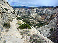 Length 14.5 miles (23.3 km) Elevation change 3600 feet (1097 meters) Difficulty Strenuous Rating (1-5) ★★★★★ The longest trail in Zion National Park, this begins in the high country along the Kolob Reservoir Road, beneath 7,890 foot Lava Point. The first few miles are across the fairly level land of Horse Pasture Plateau, through sparse pine forest then more bushy, open ground as the path gradually descends. The views become more spectacular as the trail approaches the rim of the high cliffs above Phantom Valley in the west, which is followed for 2 miles, until a steep descent to a saddle between the upper ends of Behunin and Telephone canyons. The final section is down into Telephone Canyon, on to Refrigerator Canyon, where it passes the spur path to Angels Landing, then to Zion Canyon near the Grotto picnic area. |
51. Whiterocks Trail, Snow Canyon State Park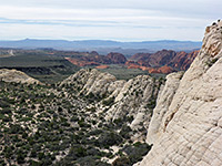 Length 1.6 miles (2.6 km) Elevation change 450 feet (137 meters) Difficulty Easy Rating (1-5) ★★★★★ The Whiterocks Trail starts in the north along Hwy 18, crossing a sandy flat to the edge of a large outcrop of white sandstone, where a 0.2 mile spur leads into the Whiterocks Amphitheater, enclosed by smooth slickrock on three sides. The main route continues southwards, crossing part of the rocks then descending a steep slope to bushy, sandy terrain, and an intersection with the Lava Flow Trail. En route are several lava caves, and for all of its length the path offers excellent views along the valley. |
52. Wittwer Canyon, Santa Clara River Reserve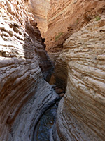 Length 7.6 miles (12.2 km); round trip Elevation change 300 feet (91 meters) Difficulty Easy to moderate - no major obstacles, just some minor wading Rating (1-5) ★★★★★ West-side tributary of the Santa Clara River, sheer-walled in places though generally rather shallow, containing a small stream that originates from springs in two upper forks, both of which form short, enclosed, slot-like channels just above the confluence |
53. Yankee Doodle Hollow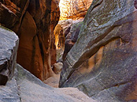 Length 0.5 miles (0.8 km) Elevation change 200 feet (61 meters) Difficulty Moderate to strenuous; several dryfalls of ten feet or more Rating (1-5) ★★★★★ Minor drainage on the south side of the Pine Valley Mountains, 25 miles west of Zion NP, forming a good, deep, quarter mile long slot at its lower end. A popular location to learn or practice rappelling techniques, though most of the canyon can be seen without equipment by hiking/climbing up from below. |
54. Yant Flat Cliffs, Yant Flat Cliffs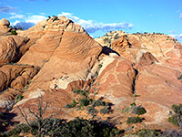 Length 2 miles (3.2 km); or more Elevation change 200 feet (61 meters) Difficulty Easy to moderate - some scrambling on steep slopes Rating (1-5) ★★★★★ Swirling, patterned sandstone in a great variety of colors, eroded into cliffs, buttes and ravines; across the southern slopes of the Pine Valley Mountains. Explored by a 1.3 mile path then off-trail hiking. |
55. Zion Narrows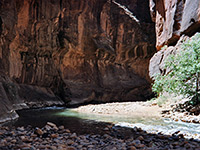 Length 15.6 miles (25.1 km); for the whole canyon Elevation change 1200 feet (366 meters) Difficulty Moderate; no great obstacles, but miles of wading in the river Rating (1-5) ★★★★★ The most famous narrow canyon hike in the Southwest, following the North Fork of the Virgin River past near vertical walls up to 2,000 feet high. Generally passable only during late summer and fall, as the water is too deep and fast flowing at other times. The full canyon is best explored from the top (perhaps with one night camping en route), but most people start at the lower end and hike just a short distance upstream. |
All Contents © Copyright The American Southwest | Comments and Questions | Contribute | Affiliate Marketing Disclosure | Site Map