Observation Point
Perhaps the best trail in the park, climbing steeply to a fantastic viewpoint over 2,000 feet above Zion Canyon. Varied scenery en route, from Weeping Rock, up to the lower narrows of Echo Canyon, then to more expansive landscapes higher up
Length: 4 miles
Elevation change: 2,150 feet
Difficulty: Strenuous
Type: One way - mostly along the East Rim Trail. Other paths branch off, allowing for continuation hikes
Usage: High at the start, medium higher up
Season: Spring, summer, fall; the upper parts are snow-covered in winter
Trailhead: Weeping Rock - shuttle stop 7
Rating (1-5): ★★★★★

Update, August 24th 2019 The Observation Point Trail has been closed for the foreseeable future due to a huge rockfall
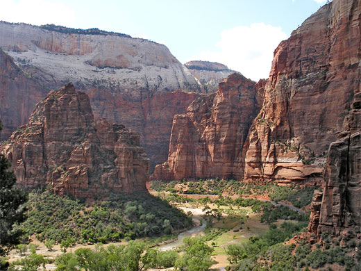
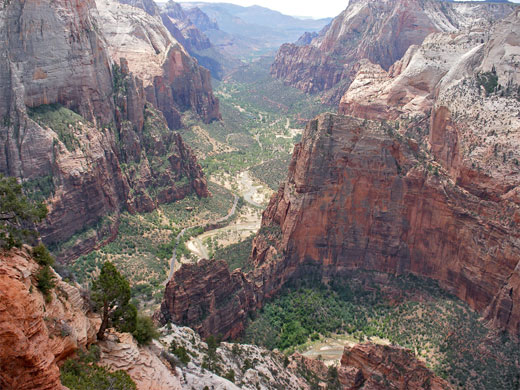
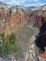
Observation Point is a narrow promontory, elevation 6,508 feet, that overlooks much of Zion Canyon including such famous landmarks as the Great White Throne, Castle Dome, Three Patriarchs and Angels Landing. The 4 mile trail to the summit climbs 2,150 feet so this is a fairly strenuous hike, though still relatively easy as all the route is well maintained, well used, and clearly signposted at junctions.
Although the view from Angels Landing on the opposite side of the canyon is slightly better, the variety of scenery on the way makes the path to Observation Point probably the best day hike in the national park, also taking in Weeping Rock, some of the narrows of Echo Canyon, and views over large areas of the eastern Zion backcountry. Hiking times for the 8 mile round trip typically range from 3 to 6 hours, via a path that uses three separate trails - 2 miles of the East Rim Trail, 1.5 miles of the East Mesa Trail then the short Observation Point Trail to the overlook.
Observation Point topographic map, location map for Zion Canyon.
26 views along the trail to Observation Point.
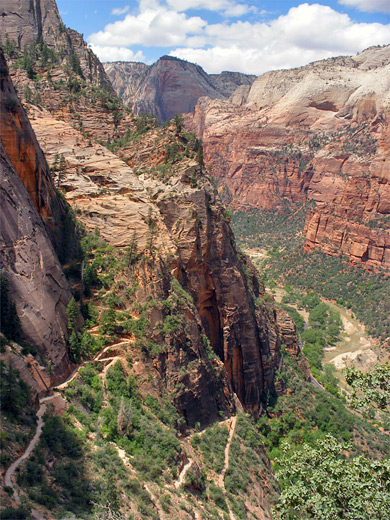
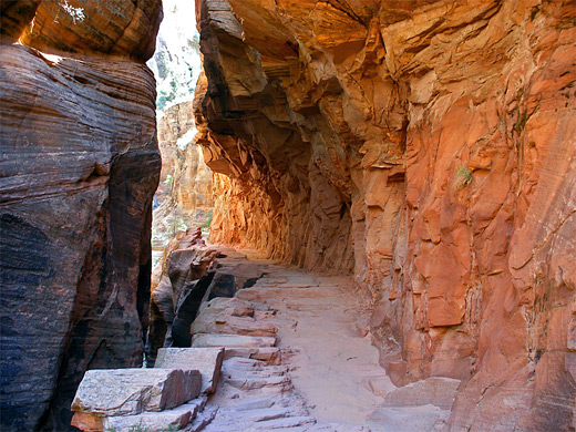
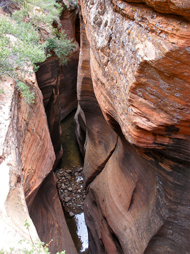
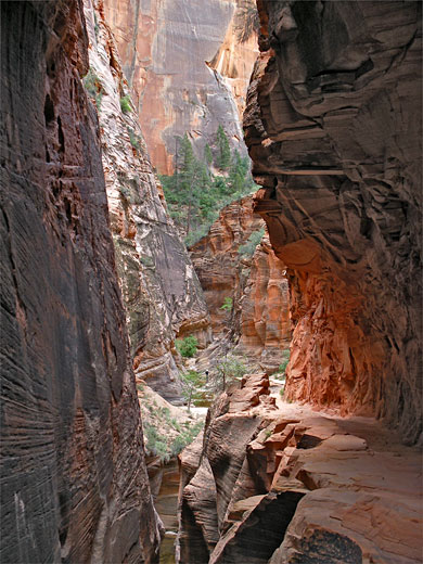
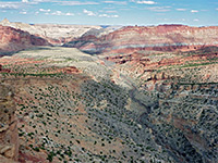
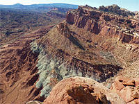
The hike commences at Weeping Rock, the main trailhead on the east side of the Virgin River, where trips begin to many other places besides Observation Point, including Hidden Canyon, Echo Canyon, Mystery Canyon, Cable Mountain, Deertrap Mountain, and the eastern park entrance along UT 9. Between early April and late October, the rock is only reachable by the free shuttlebus system - a 20 minute ride (to stop number 6) starting from the visitor center by the Watchman Campground. The first part of the East Rim Trail is usually quite busy, as it switchbacks up a steep talus slope at the edge of the cliffs, gaining 400 feet to the junction with the Hidden Canyon Trail - the destination for most visitors. The next section has several more switchbacks, ending with a northerly traverse of the mountainside towards the edge of Echo Canyon, where the trail cuts back east, running alongside the ravine though many feet above the streambed, and becomes quite sheltered by oak trees and bushes. Echo is a narrow slot canyon, and a glance into the depths reveals boulders, pools and twisting channels, features still present further along the path as the canyon floor quickly rises via a series of dryfalls, and for a short distance the trail follows the streambed.
The East Rim Trail climbs above Echo Canyon on the north side, passing above a particularly deep, enclosed passage via a section chiseled out of a vertical sandstone rock face, into a more open area where the streamway is accessible once more - this is the place to start if exploring the main Echo Canyon narrows from below. The trail stays quite close to the drainage for another half mile or so, though quickly rises far above, passing round a sharp bend then turning due north, climbing up the side of a ridge and moving away from the slot. It winds beneath the foot of a line of tall white cliffs, affording ever more wide ranging views of the forested valley of upper Echo Canyon and the flat plateau to the south (Cable Mountain), and in early summer encounters an unusually diverse collection of wildflowers, with species of every color imaginable.
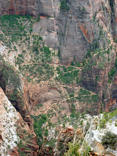
The next junction, 2 miles from the start, is with the East Mesa Trail, which forms the next part of the route to Observation Point. This is quite steep at first, ascending through several wide switchbacks across a spur of land separating the cliff face from a narrow ravine just to the east. The last switchback is partly into this crevasse, then the path bends westwards, cutting through a sheer rock face that is quite devoid of any vegetation. After 2 more long zig-zags, the route reaches the top of the whitish Temple Cap sandstone layer and becomes nearly level as it trends northwest along the rim of a plateau, through crumbling, layered, red rocks of the Chinle formation - now quite overgrown with bushes, trees, yucca and cacti (most visibly opuntia and echinocereus). For about a mile the path runs along the rim, with grand views south towards Zion Canyon, Echo Canyon, and the switchbacks of the trail to Hidden Canyon.
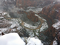
The East Mesa Trail veers away from the cliff edge, across a bushy area showing signs of recent fire damage (2006), passing many blackened bushes and trees, now surrounded by new green growth, and lots more flowers. The next junction is with the actual Observation Point Trail, a level, 0.5 mile path to the viewpoint, which is located at the end of a narrow spur of land, where the edge falls away vertically on three sides. The best views are south, down the Virgin River, and back east along Echo Canyon. North is not so good a direction as intermediate cliffs obscure the course of the river, and the Narrows, although quite a lot of the river is in view, as it flows from Temple of Sinawava and round Big Bend, past The Organ and Weeping Rock.
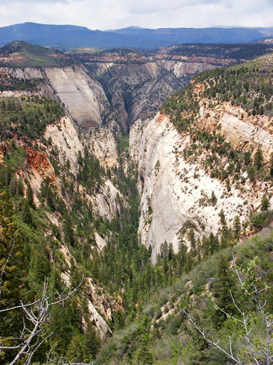
Observation Point is certainly a fine viewpoint, though not one likely to be enjoyed alone, as at any one time on busy summer days there may be a dozen or more groups resting on the summit. More peaceful is the continuation path north (the East Mesa Trail); this climbs gradually, round the upper end of a side canyon on the left side then another on the right, up to a high point of 6,820 feet in the middle of a wooded plateau. The next mile is mostly level, as the path passes the end of Mystery Canyon, following close to the east rim for a while. Mystery is a deep, straight drainage backed by the inaccessible Mountain of Mystery, just below which the ravine bends by 90 degrees and heads west towards Zion Canyon. It is also one of the premier technical canyoneering locations in Zion National Park - a varied journey involving about a dozen rappels of up to 120 feet. The remaining 1.5 miles of the East Mesa Trail cross more flattish, sandy, partly wooded land before joining a 4WD track at the park boundary, a point reachable by driving 8 miles north from UT 9.
Observation Point is a narrow promontory, elevation 6,508 feet, that overlooks much of Zion Canyon including such famous landmarks as the Great White Throne, Castle Dome, Three Patriarchs and Angels Landing. The 4 mile trail to the summit climbs 2,150 feet so this is a fairly strenuous hike, though still relatively easy as all the route is well maintained, well used, and clearly signposted at junctions.
Although the view from Angels Landing on the opposite side of the canyon is slightly better, the variety of scenery on the way makes the path to Observation Point probably the best day hike in the national park, also taking in Weeping Rock, some of the narrows of Echo Canyon, and views over large areas of the eastern Zion backcountry. Hiking times for the 8 mile round trip typically range from 3 to 6 hours, via a path that uses three separate trails - 2 miles of the East Rim Trail, 1.5 miles of the East Mesa Trail then the short Observation Point Trail to the overlook.
Maps
Observation Point topographic map, location map for Zion Canyon.
Photographs
26 views along the trail to Observation Point.
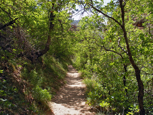
Start of the Observation Point Trail
The hike commences at Weeping Rock, the main trailhead on the east side of the Virgin River, where trips begin to many other places besides Observation Point, including Hidden Canyon, Echo Canyon, Mystery Canyon, Cable Mountain, Deertrap Mountain, and the eastern park entrance along UT 9. Between early April and late October, the rock is only reachable by the free shuttlebus system - a 20 minute ride (to stop number 6) starting from the visitor center by the Watchman Campground. The first part of the East Rim Trail is usually quite busy, as it switchbacks up a steep talus slope at the edge of the cliffs, gaining 400 feet to the junction with the Hidden Canyon Trail - the destination for most visitors. The next section has several more switchbacks, ending with a northerly traverse of the mountainside towards the edge of Echo Canyon, where the trail cuts back east, running alongside the ravine though many feet above the streambed, and becomes quite sheltered by oak trees and bushes. Echo is a narrow slot canyon, and a glance into the depths reveals boulders, pools and twisting channels, features still present further along the path as the canyon floor quickly rises via a series of dryfalls, and for a short distance the trail follows the streambed.
Echo Canyon
The East Rim Trail climbs above Echo Canyon on the north side, passing above a particularly deep, enclosed passage via a section chiseled out of a vertical sandstone rock face, into a more open area where the streamway is accessible once more - this is the place to start if exploring the main Echo Canyon narrows from below. The trail stays quite close to the drainage for another half mile or so, though quickly rises far above, passing round a sharp bend then turning due north, climbing up the side of a ridge and moving away from the slot. It winds beneath the foot of a line of tall white cliffs, affording ever more wide ranging views of the forested valley of upper Echo Canyon and the flat plateau to the south (Cable Mountain), and in early summer encounters an unusually diverse collection of wildflowers, with species of every color imaginable.
East Mesa Trail
The next junction, 2 miles from the start, is with the East Mesa Trail, which forms the next part of the route to Observation Point. This is quite steep at first, ascending through several wide switchbacks across a spur of land separating the cliff face from a narrow ravine just to the east. The last switchback is partly into this crevasse, then the path bends westwards, cutting through a sheer rock face that is quite devoid of any vegetation. After 2 more long zig-zags, the route reaches the top of the whitish Temple Cap sandstone layer and becomes nearly level as it trends northwest along the rim of a plateau, through crumbling, layered, red rocks of the Chinle formation - now quite overgrown with bushes, trees, yucca and cacti (most visibly opuntia and echinocereus). For about a mile the path runs along the rim, with grand views south towards Zion Canyon, Echo Canyon, and the switchbacks of the trail to Hidden Canyon.
The Summit
The East Mesa Trail veers away from the cliff edge, across a bushy area showing signs of recent fire damage (2006), passing many blackened bushes and trees, now surrounded by new green growth, and lots more flowers. The next junction is with the actual Observation Point Trail, a level, 0.5 mile path to the viewpoint, which is located at the end of a narrow spur of land, where the edge falls away vertically on three sides. The best views are south, down the Virgin River, and back east along Echo Canyon. North is not so good a direction as intermediate cliffs obscure the course of the river, and the Narrows, although quite a lot of the river is in view, as it flows from Temple of Sinawava and round Big Bend, past The Organ and Weeping Rock.
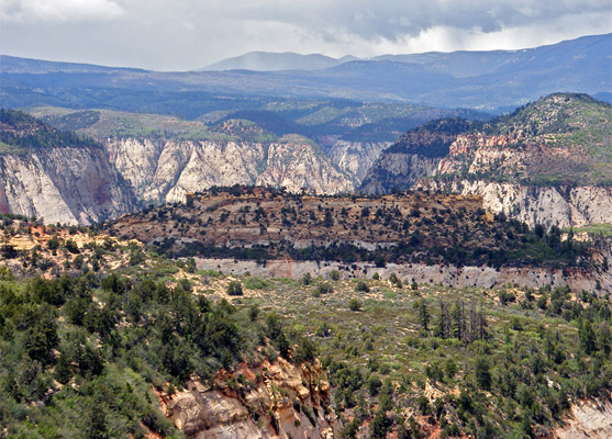
Mystery Canyon
Observation Point is certainly a fine viewpoint, though not one likely to be enjoyed alone, as at any one time on busy summer days there may be a dozen or more groups resting on the summit. More peaceful is the continuation path north (the East Mesa Trail); this climbs gradually, round the upper end of a side canyon on the left side then another on the right, up to a high point of 6,820 feet in the middle of a wooded plateau. The next mile is mostly level, as the path passes the end of Mystery Canyon, following close to the east rim for a while. Mystery is a deep, straight drainage backed by the inaccessible Mountain of Mystery, just below which the ravine bends by 90 degrees and heads west towards Zion Canyon. It is also one of the premier technical canyoneering locations in Zion National Park - a varied journey involving about a dozen rappels of up to 120 feet. The remaining 1.5 miles of the East Mesa Trail cross more flattish, sandy, partly wooded land before joining a 4WD track at the park boundary, a point reachable by driving 8 miles north from UT 9.
Observation Point - Similar Hikes
All Contents © Copyright The American Southwest | Comments and Questions | Contribute | Affiliate Marketing Disclosure | Site Map