Angels Landing
This famous trail climbs steeply up the cliffs on the west side of Zion Canyon for a panoramic view over the surrounding landscape. The final 0.5 miles is along a narrow ridge with sheer drops on either side; chains are provided to assist the ascent. As of 2022, a permit is required for this section
Length: 2.5 miles
Elevation change: 1,500 feet
Difficulty: Moderate to strenuous
Type: One way. Most of the route is along the West Rim Trail, which continues northwards for many miles
Usage: High
Season: All year, but spring and fall are best. May be icy winter, and very hot in summer
Trailhead: The Grotto - shuttle stop 6
Rating (1-5): ★★★★★

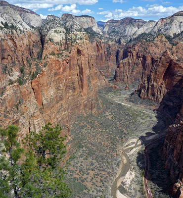
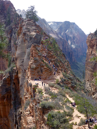
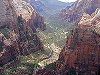
In complete contrast to Zion National Park's other world-famous hike, the level Zion Narrows Trail, the route to Angels Landing, constructed in 1926, ascends 1,500 feet over a distance of 2.5 miles to a narrow, slickrock summit, which is ringed on three sides by the Virgin River far below and has amazing views in both directions up and down Zion Canyon. This is generally considered the best high elevation viewpoint in the park, slightly superior to Observation Point opposite since more of the upstream canyon is visible. The peak was named by a Methodist clergyman, Frederick Vining Fisher, who thought that 'only an angel could land on it'; he was also responsible for naming other Zion landmarks such as the Great White Throne and the Three Patriarchs.
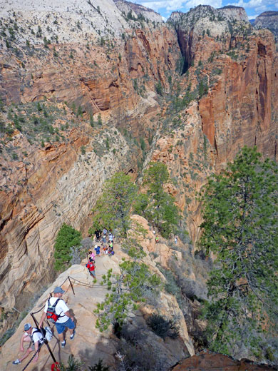
The round trip can be done in less than two hours, though the NPS suggest four hours is the average time. The trail is somewhat notorious because of the final section, which climbs 450 feet up a thin sloping ridge, aided via stairs, railings and chains, in places just one step away from the edge of the sheer cliffs. Although not difficult for experienced hikers, this section has gained an intimidating reputation, yet is also regarded as a challenge by some people perhaps unsuited to such activities, which explains the high accident rate - with 14 fatalities since 1983, the Angels Landing Trail might be the most dangerous hike in any national park. The most recent occurred in March 2021, when a 43 year old man fell from the ridge. Nevertheless, the route to Angels Landing is regarded as one of the most remarkable trails in the whole national park system.
Angels Landing topographic map, location map for Zion Canyon.
32 views along the West Rim and Angels Landing Trails.
The ever-increasing popularity of the Angels Landing Trail led the NPS to introduce a permit system in 2022. Permits are required only for the spur trail to the summit, from Scout Lookout, not the West Rim Trail which makes up the majority of the route. There are two methods to acquire a permit; one is the Seasonal Lottery, where hikers choose seven potential hike dates/times, applying up to four months in advance, then a selection are drawn at random and the successful applicants notified. The other method is the Day-before Lottery; hikers apply between 12.01 am and 3 pm the day before the intended hike, with results being announced at 4 pm on that day. A non-refundable fee of $6 (in 2024) must accompany all applications, while the actual permits cost $3.
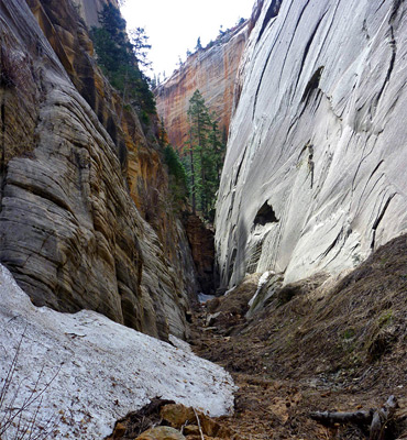
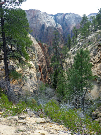
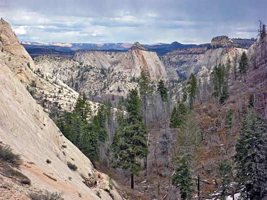
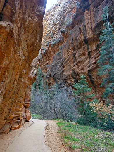
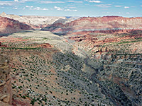
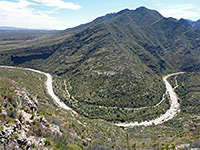
Although the trail to Angels Landing is popular and well maintained, the route is rated strenuous and not recommended for anyone fearful of heights, a warning which applies mostly to the last section. The path starts unspectacularly just north of Zion Lodge halfway along the scenic drive (shuttle stop number 6 - The Grotto), initially following the road through shady, tree-covered land then crossing the Virgin River on a footbridge. This part is the southern end of the West Rim Trail, a long cross country route that has a northern terminus near Lava Point in the far north of the park - 14.5 miles away. The path is paved at first and fairly level, before leaving the shade of the pine/oak trees and climbing steadily up the west side of the main canyon via several sharp switchbacks and then turning away along Refrigerator Canyon, a cool, sheltered side valley lined by dark, vertical walls of Navajo sandstone. Tall Douglas fir trees grow here, one of the few places in the park where this species can be seen. The trail soon starts to climb above the canyon floor but an unofficial route follows the sandy streambed a little way, before being stopped by a dryfall.
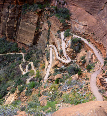
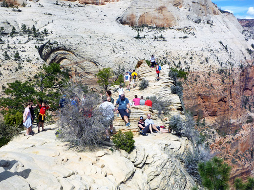
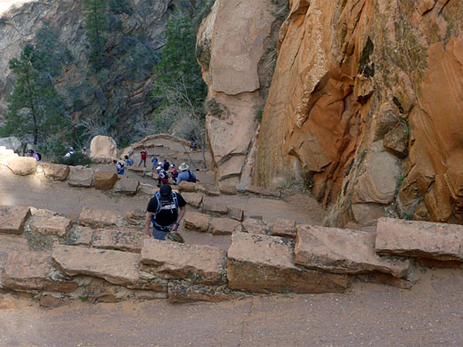
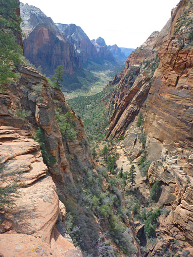
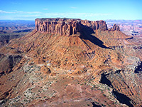
An even steeper series of switchbacks (Walter's Wiggles - 21 tight bends as the path ascends nearly 400 feet) leads up the east wall of Refrigerator Canyon to the narrow saddle of Scout Lookout , where the surfaced trail ends, just before a junction where the West Rim Trail continues northwards. The switchbacks are named after a former superintendent of Zion National Park, Walter Ruesch, who helped design the route in the 1920s. At the trail junction, the last half mile of the path - the Angels Landing Trail - ascends southwards along the ridge to the summit, and is marked by rock cairns, occasional steps carved in the rock and chains which have been fixed for safety at several particularly steep places. At some points, the ridge is only a few feet wide, with sheer drop-offs at either side, so great caution is necessary. Unfortunately, because of the popularity of the hike, the slow progress of some people over the narrow sections, and the fact that for most of the way there is only one possible route, long queues can build up, and what could for some be a ten minute climb can take an hour or more. The summit is fairly flat for about 200 feet, so there is at least plenty of room for everyone once at the top.
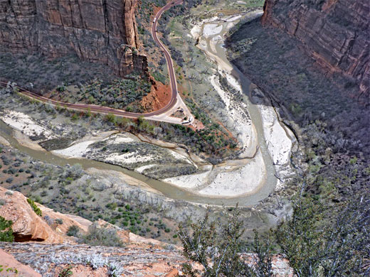
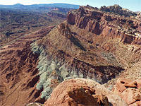
The summit feels like the top of the world, although there are slightly higher cliffs visible in the distance, in all directions. The views up and down Zion Canyon are of an almost mythical landscape of red and white mountains, with the river far below winding into the misty distance. Other nearby summits include flat-topped Cathedral Mountain to the west, the Great White Throne to the south, Cable Mountain due east and Observation Point to the north, plus the slightly lower peak of the Organ, an eastwards continuation of the Angel's Landing promontory.
The round trip can be done in less than two hours, though the NPS suggest four hours is the average time. The trail is somewhat notorious because of the final section, which climbs 450 feet up a thin sloping ridge, aided via stairs, railings and chains, in places just one step away from the edge of the sheer cliffs. Although not difficult for experienced hikers, this section has gained an intimidating reputation, yet is also regarded as a challenge by some people perhaps unsuited to such activities, which explains the high accident rate - with 14 fatalities since 1983, the Angels Landing Trail might be the most dangerous hike in any national park. The most recent occurred in March 2021, when a 43 year old man fell from the ridge. Nevertheless, the route to Angels Landing is regarded as one of the most remarkable trails in the whole national park system.
Maps
Angels Landing topographic map, location map for Zion Canyon.
Photographs
32 views along the West Rim and Angels Landing Trails.
Angels Landing Video
Angels Landing Permits
The ever-increasing popularity of the Angels Landing Trail led the NPS to introduce a permit system in 2022. Permits are required only for the spur trail to the summit, from Scout Lookout, not the West Rim Trail which makes up the majority of the route. There are two methods to acquire a permit; one is the Seasonal Lottery, where hikers choose seven potential hike dates/times, applying up to four months in advance, then a selection are drawn at random and the successful applicants notified. The other method is the Day-before Lottery; hikers apply between 12.01 am and 3 pm the day before the intended hike, with results being announced at 4 pm on that day. A non-refundable fee of $6 (in 2024) must accompany all applications, while the actual permits cost $3.
Start of the West Rim Trail
Although the trail to Angels Landing is popular and well maintained, the route is rated strenuous and not recommended for anyone fearful of heights, a warning which applies mostly to the last section. The path starts unspectacularly just north of Zion Lodge halfway along the scenic drive (shuttle stop number 6 - The Grotto), initially following the road through shady, tree-covered land then crossing the Virgin River on a footbridge. This part is the southern end of the West Rim Trail, a long cross country route that has a northern terminus near Lava Point in the far north of the park - 14.5 miles away. The path is paved at first and fairly level, before leaving the shade of the pine/oak trees and climbing steadily up the west side of the main canyon via several sharp switchbacks and then turning away along Refrigerator Canyon, a cool, sheltered side valley lined by dark, vertical walls of Navajo sandstone. Tall Douglas fir trees grow here, one of the few places in the park where this species can be seen. The trail soon starts to climb above the canyon floor but an unofficial route follows the sandy streambed a little way, before being stopped by a dryfall.
The Main Ascent
An even steeper series of switchbacks (Walter's Wiggles - 21 tight bends as the path ascends nearly 400 feet) leads up the east wall of Refrigerator Canyon to the narrow saddle of Scout Lookout , where the surfaced trail ends, just before a junction where the West Rim Trail continues northwards. The switchbacks are named after a former superintendent of Zion National Park, Walter Ruesch, who helped design the route in the 1920s. At the trail junction, the last half mile of the path - the Angels Landing Trail - ascends southwards along the ridge to the summit, and is marked by rock cairns, occasional steps carved in the rock and chains which have been fixed for safety at several particularly steep places. At some points, the ridge is only a few feet wide, with sheer drop-offs at either side, so great caution is necessary. Unfortunately, because of the popularity of the hike, the slow progress of some people over the narrow sections, and the fact that for most of the way there is only one possible route, long queues can build up, and what could for some be a ten minute climb can take an hour or more. The summit is fairly flat for about 200 feet, so there is at least plenty of room for everyone once at the top.
Angel's Landing Summit
The summit feels like the top of the world, although there are slightly higher cliffs visible in the distance, in all directions. The views up and down Zion Canyon are of an almost mythical landscape of red and white mountains, with the river far below winding into the misty distance. Other nearby summits include flat-topped Cathedral Mountain to the west, the Great White Throne to the south, Cable Mountain due east and Observation Point to the north, plus the slightly lower peak of the Organ, an eastwards continuation of the Angel's Landing promontory.
Nearby Trails
Angels Landing Wildflower
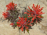 Castilleja scabrida |
Angels Landing - Similar Hikes
All Contents © Copyright The American Southwest | Comments and Questions | Contribute | Affiliate Marketing Disclosure | Site Map